This updated article was originally published with some edits in the December 2013 edition of the Atlantic Daily Bulletin of the British Titanic Society.
THE PRINZ ADALBERT ICEBERG: The iceberg that did not sink the Titanic
Brian T. Hill, Alan Ruffman and Rolf-Werner Baak
Introduction
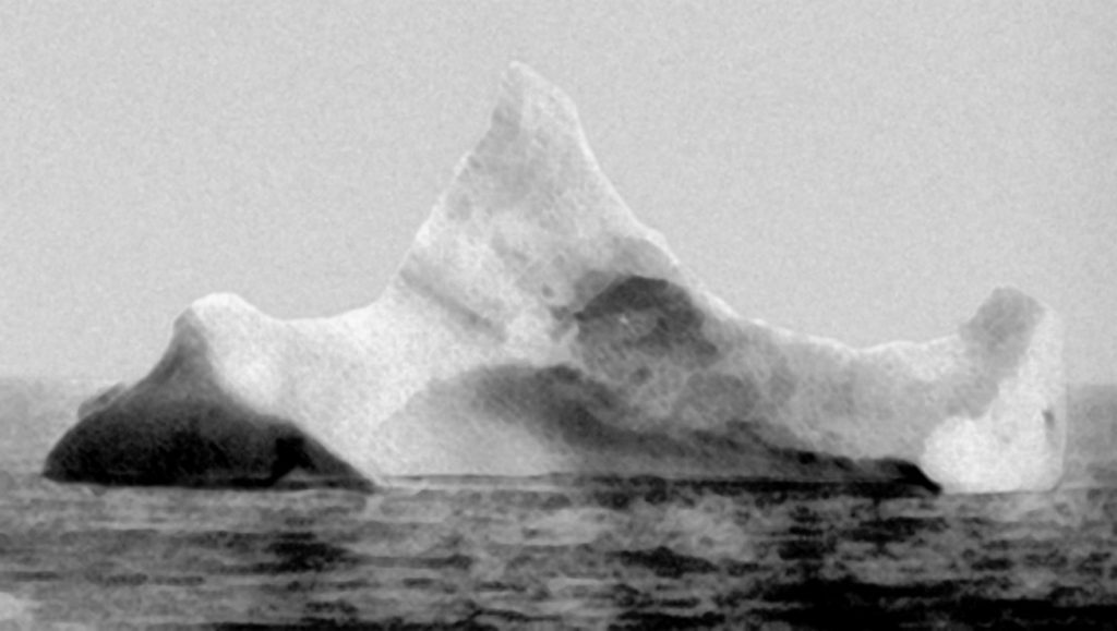
There has been much discussion in the press recently, and indeed elsewhere, about the genuineness of certain Titanic artifacts offered up for auction. These items are principally the violin said to be that of Wallace Hartley, the famed bandleader who according to tradition was still playing as water lapped at his feet as the ship was sliding away beneath him, and photographs of the supposed actual iceberg which had performed the foul deed of sinking the Titanic. Indeed, the authors were in the process of researching the documentation relevant to these when they came across a discrepancy in the dates associated with a photograph of one of the icebergs. The auction house was advertising for sale a photograph of an iceberg that supposedly sank the Titanic as seen by the SS Etonian on 12 April 1912, two days before the actual collision. In their catalogue description, the auction house implied that the iceberg seen by the SS Prinz Adalbert reproduced in Walter Lord’s classic book, A Night To Remember,[1] was the same iceberg as that photographed from the SS Etonian (Figure 1). The caption to the photograph in Lord’s book reads in full:
“Many an iceberg has been identified as “the iceberg that sank the Titanic,” but this one has a better pedigree than most. It was photographed near the scene on April 15. The Chief Steward of the German ship Prinz Adelbert[sic] took the picture, not because of the Titanic – he hadn’t yet heard – but because a great scar of red paint ran along the berg’s base. It suggested a recent collision with some ship. White Star Vice president Philip A.S. Franklin was sufficiently impressed that he always refused to look at the picture.”
In this paper we show that the Prinz Adalbert could not have seen the iceberg that sank the Titanic because it passed north of the collision site on the April 16th, not the 15th, and by then the iceberg was well to the south. In addition we show that the officers and likely most of the crew had already been alerted to the disaster. The “great scar of red paint” is not discussed here. It is quite impossible to tell from the black and white photograph what is being referred to and if a red discoloration existed then it could be due to a number of things. Since the authors intend showing that it was impossible for this berg to have sunk the Titanic due to its location then the cause of the redness becomes irrelevant to this discussion.
The date April 15th or the 16th
No-one appears to know how, or where, Lord obtained the photograph. There appears to be no known history of the photo in the 44 years prior to the 1955 publication of A Night To Remember, and Lord does not give a source for the photograph. To date we have been unable to establish the name of the Chief Steward of the Prinz Adalbert. The photograph is not found in the Lord-McQuitty Collection at the National Maritime Museum in Greenwich, England. The discrepancy lies in the date the photograph was supposed to have been taken, “near the scene on April 15″, a date that has since been parroted in many books and articles, including in material supplied by the Henry Aldridge auction house in England in the lead-up to an October 19, 2013 auction sale. Our own records initially from the Hydrographic Bulletin indicated that Prinz Adalbert was in the ice on the 16th of April, not on the 15th. With the typical flow of the Labrador Current heading south along the coast of Labrador and south along the east coast of Newfoundland and south along the easternmost edge of the Continental Shelf edge of the Grand Banks, it is difficult to imagine an iceberg standing still long enough to be essentially in the same place for a day or so, as in the time interval between the sinking of the Titanic on the 15th and being seen by the Prinz Adalbert, never mind the three or four day time interval between being seen by the Etonian and the Prinz Adalbert. But which date was correct: the 15th or the 16th?
Sources of ice and iceberg data in the North Atlantic
The first two authors have been documenting historical ice conditions2 off the Canadian east coast and the Grand Banks area for several decades now, and have compiled tens of thousands of ice reports. The reports have been gleaned from a variety of sources, but prior to aviation the vast majority of ice reports originated with trans-Atlantic or coastal shipping, with a small percentage coming from land stations such as lighthouses and personal diaries. Prior to the sinking of the Titanic and the subsequent formation of the International Ice Patrol (IIP) which was responsible for the collection and dissemination of ice information for the protection of trans-Atlantic shipping, several of the larger newspapers such as the New York Times and New York Herald published occasional information in their columns of marine intelligence. Further information might be found in some of the maritime newspapers such as Lloyd’s List and the New York Maritime Register, and for a few years the Monthly Weather Review of the U.S. government published lengthy lists of ice observations, this perhaps in response to the increasing severity of ice conditions at the time.
Then, almost by accident, though aware of it through the occasional obscure reference, the authors stumbled across a photocopy of a weekly, the Hydrographic Bulletin of the U.S. Hydrographic Office, while researching ice data at the U.S. National Archives and Records Administration in Washington, D.C., in 2001. Further searching at their College Park, Maryland, archive in 2007 produced almost the full series of the weekly Hydrographic Bulletin (HB)3 published from 1889 until 1947 containing a wealth of ice information, and other hazards to navigation, particularly useful for the pre- and early formative years of the International Ice Patrol.
The Hydrographic Bulletin and newspaper sources
An entry in the HB No. 1182, April 24, 1912, reads:
“April 16. Between 42°03′ N 48°57′ W and 41°40′ N 50°15′ W encountered field ice, icebergs, and growlers. Prinz Adelbert[sic] (Ger.ss.), Bambur. [Radiogram]”
However, typographical errors in newspapers, or in reporting, are not uncommon, and also just possibly the date of the 16th might be the date of the radiogram rather than the date of an earlier observation. Having limited radio range though, and still being some distance from land, such a message would have had to be relayed by another ship, and generally in such instances the reports would have stated this. So, the authors continued their search in other sources for confirmation of the date and, while a number of newspapers such as Lloyd’s List, the New York Maritime Register, and the New York Herald gave an almost exact version of the message reproduced in the Hydrographic Bulletin, they were all without a date. Paul Lee in his Titanic website4 and the Titanic Inquiry Project (TIP) page on the Prinz Adalbert,5 credited to John P. Eaton, both gave a date of the 16th, and the ice descriptions were more detailed than had been found so far, implying that their information had come from another source, not referenced. John P. Eaton had published details of the track of the Prinz Adalbert in Voyage 705 but had not given the details of his source. Jack Eaton was contacted and he was able to supply the British Public Record Office reference that was needed, and arrangements were made through an interlibrary loan to acquire a copy of the source material in CD-ROM format.
European and German-language sources
The search was now broadened in an attempt to find the departure and arrival times of the Prinz Adalbert on its voyage from Hamburg to Philadelphia. By establishing these times, the ship’s overall average speed could then be determined and estimates made as to where the ship should have been on April 15th and 16th. The search was also extended to other Titanic researchers to bring in their fields of expertise, particularly to our German-speaking counterparts where our lack of knowledge of the national archiving system and a lack of German language facility were obvious limitations.
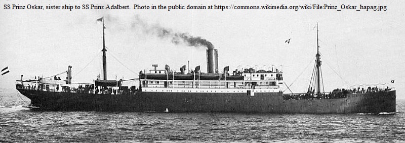
The Prinz Adalbert, sister ship to the Prinz Oskar and one of the seven ships of the Prinzen Class owned by the Hamburg-Amerika Linie, later to become Hapag-Lloyd, was a 6,030 gross registered ton, 10-year-old, 123 m long vessel built at the Bremer Vulcan yard, Vegesack. With a capacity of 121 crew and 1,418 passengers, the Prinz Adalbert’s 3,350 hp two quadruple expansion steam engines propelling twin screws had a maximum speed of 12.5 knots,6 but if this trip was anything to go by then she would be hard pushed to match that speed in 1912.
Evidently, at about this time her normal master was a Captain Dugge, and it was expected that he would be the captain on the next sailing out of Hamburg on March 31st.7 This apparently did not happen, since the Prinz Adalbert next sailed out on April 6th with Capt. Brambeer in charge, misspelled in the above-quoted HB 24 April report. 45-year-old Capt. Theodor Brambeer had been with the line for some time as master, possibly more than a decade, and was noted as having been in charge of such ships as the Georgia,8 Acilia9 and Sibiria.10 This would be one of his last voyages as he passed away the following year.
The departure from Hamburg was recorded by the New York Herald as being at 11:45 p.m.11 on April 6th still assuming that Capt. Dugge was in command, thereby commencing a 70 mile or so run down the River Elbe to the open sea. At the other end of the voyage Philadelphia lay some 85 miles beyond the entrance to Delaware Bay and up the tortuous Delaware River. Navigation of both these inland waterways obviously demanded great care and was very much influenced by tides and weather such as fog and high winds. The time of arrival has not been found in any of the major stateside newspapers, but the date has been given as April 20th.12,13 However, the ‘Manifest of Alien Passengers’ is signed and dated with an arrival date of the 21st.14 This suggested that the ship may have arrived sufficiently far up-river for the press to record her arrival as the 20th, but perhaps she did not arrive dockside until the early hours of the morning of the 21st and then had to wait for immigration procedures. Captain Brambeer was the captain who signed the immigration documents in Philadelphia, not Capt. Dugge.
A departure time of the Prinz Adalbert of 11:45 p.m. on April 6th from Hamburg had thus been established, and Lloyd’s List provided a date of April 8th for passing Dover15 and a time and date of 8:20 a.m. on April 9th of being 50 miles to the east of the Lizard,16 a reef near the western entrance to the English Channel (although this time was later to prove suspect as it could not be reconciled with times given in the ship’s meteorological log). The ice description given in the Titanic Inquiry Project also provided 3:30 a.m. on the 16th as the time of seeing the first ice, and 10:00 a.m. as the time of clearing the last ice, and already approximations from the vessel’s speed from these times and locations were beginning to confirm an ice observation date of April 16th rather than the 15th. Up until this point of time the authors were beginning to think that no-one else had noticed the discrepancy in dates. However we would like to recognise the postings of David Gittins of Victoria, Australia, on the website http://www.encyclopedia-titanica.org dated 29 November 2003,17 12 November 200618 and 27 March 2009,19 in which he expressed his misgivings that the Prinz Adalbert could have seen the culprit iceberg, as by a day later the iceberg would have drifted well beyond the scene. We confirm his misgivings in this article and present a careful documentation for the dates and Prinz Adalbert’s track, and hopefully draw all the threads together in a coherent fashion.
June 29, 1912 letter to the Board of Trade in London by the Hamburg-Amerika Linie
Then, almost simultaneously, the authors received both the CD-ROM produced by the British Public Record Office via an interlibrary loan, and a copy of the appropriate pages of the meteorological log of the Prinz Adalbert which arrived from Rolf-Werner Baak in Hamburg, Germany. We present a verbatim transcript of the whole letter from the Hamburg-Amerika Linie to the Assistant Secretary, Marine Department, Board of Trade in London, England, dated Hamburg June 29th 1912, as found at the Public Record Office of the British National Archives:20
“Gentlemen,
Referring to our different respects, in reply to your favour of the 6th inst., we had to-day the captain of our s.s. “Prinz Adalbert” here, who reported as follows:
On the 14th April I received from the “Caronia” by wireless telegramm a detailed ice-report. On the 16th April 3.30 a.m. we sighted the first ice-berg on latitude 42°03 N., longitude 48°57 W. We kept our true course S78°W but reduced our speed from 3.30 a.m. till 3.57 a.m. Wind was N.W.1/2 smooth sea and clear weather but overcast sky. At day-break in clear weather, we saw in the South, in addition to single bergs, a huge field of ice with several more or less high peaks stretching as far as the eye could reach. Towards 8 a.m. we found that this field, in horseshoe form, also extended to the North. We altered our course to the South, and steamed along the field in order to break through at a suitable spot when the floes were less compact, and where the western boundary of the field was clearly to been[sic] discerned. Our true courses we steered from 8[sic] a.m. were the following:
S 62° W 4 miles
S 77° W 5 “
S 18° W 12 “
S 78° W 7 “
At 8.40 a.m. we found such a suitable spot, and after we had gone through the field with the engines working slowly from 8.45 a.m. till 9.55 a.m.; we once more gained open water on the other side at 10 a.m. and took up our true course S 85° W. Latitude 41° 37′ N, long. 50°.14′ W.
In reply to your last question we beg to acknowledge that the instructions we gave years ago to our Captains in the North Atlantic trade about courses, are the following:
Our Captains have to keep the track strictly, unless there is any very urgent reason for deviation, but they have the right to leave their course if they consider this necessary for the safety of the ship. We leave it to the discretion of our commanders to deviate or slacken speed, or to take any other measures they deem fit to avoid danger.
Enclosed you will find the Captains copy of the wireless telegramm received from the “Caronia”.
We are, Gentleman,
Your most obedient servants
Hamburg-Amerika Linie
Nautische Abteilung
(signed) F.V. Reichenbächer.”
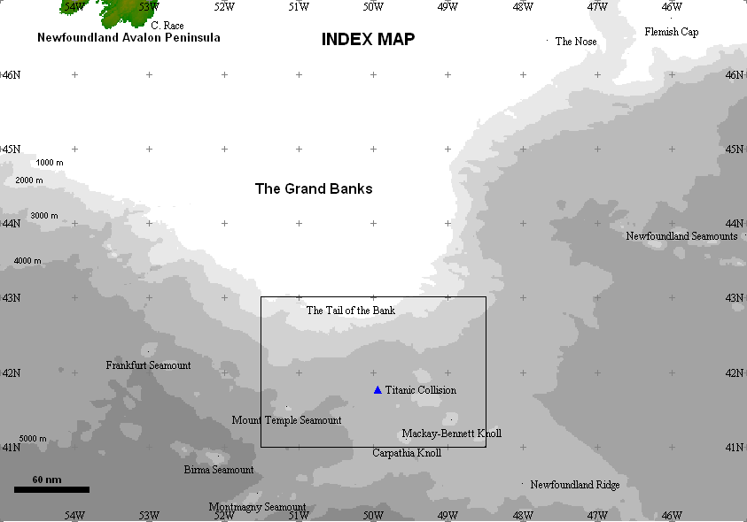
Figure 2 is a general map of the area showing the estimated location of the collision of the Titanic with the iceberg at 41°46’36″N, 49°56’48″W21 in relation to the Grand Banks and Cape Race at the southeastern extremity of the island of Newfoundland. The rectangular outline with the Titanic collision location near its midpoint is the area shown in Figure 3. This figure shows the track of the Prinz Adalbert based on the information above showing the 3:30 a.m. position on first observing ice and the course alterations made to clearing the ice at 10:00 a.m. The plotted course alterations were calculated by working back from the 10 a.m. position in nautical miles.
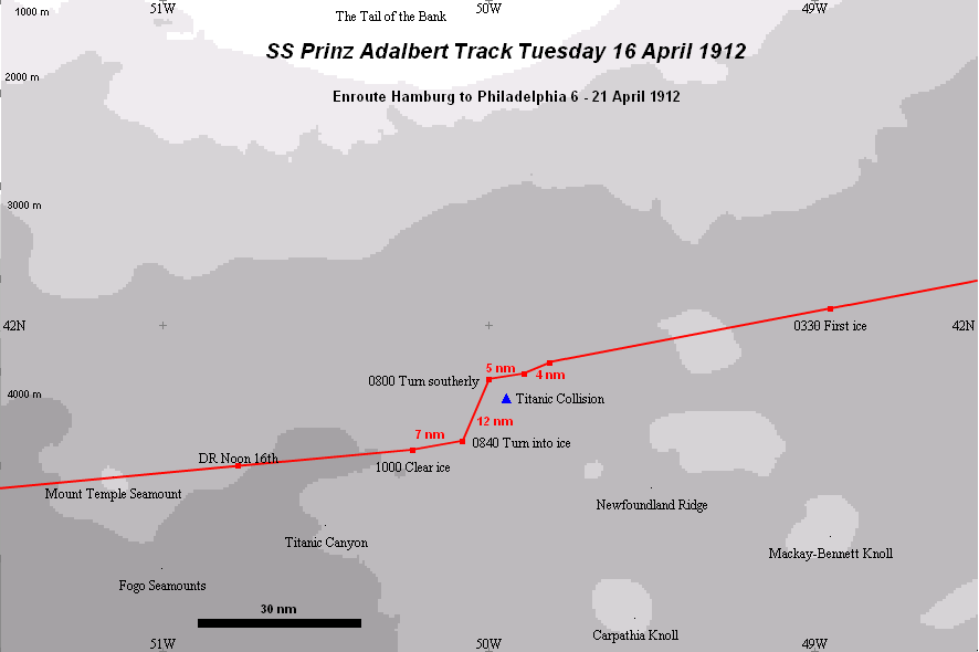
The sum of the miles travelled after 8 a.m. in the above list of courses and distances is 28, and the description implies that all the course changes were made within the 2-hour period from 8 a.m. to 10 a.m. which clearly cannot be as the ship would have had to travel at 14 knots, far faster than at any point in her voyage, and that while navigating through ice in which we are told she was going very slowly at times. An examination of the track illustrated in Figure 3 reveals what was likely meant in the description. Working back from the 10 a.m. position of clearing the ice, the overall course changes of 28 miles puts the ship back on her original course of S78°W (258°) after leaving her 3:30 position, so the distance appears to be essentially correct. However, along this track the first two course changes made are fairly small; first a 16° change to the south, then a 15° change north back to almost her original course. Then comes a significant course change to almost straight south (18° west of south) made no doubt as the ice edge in the horseshoe shape swept around to intervene. The position of this course change is calculated to be 41°50’N, 50°00’W, and it is suggested that this is the 8:00 position in the captain’s narrative when he headed south to avoid the ice and to start looking for a way through. So, though the total distance of course changes is 28 miles the actual time spent actively negotiating the ice was the 2-hour time period from 8 a.m. to 10 a.m.
Meteorological log of Prinz Adalbert
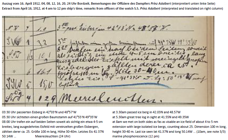
Confirmation of the 8 a.m. position comes from the Meteorological Log22 (Figure 4). The log is handwritten, of course, and its legibility is not the clearest in places. In the log what has been described as the 3:30 a.m. position actually looks more like 3:50 a.m. (we accept 3:30 a.m.), and the latitude could easily be taken as 42°13’N rather than 42°03’N (see Figure 5 for a close-up image of this part of the log and a translaton of the Remarks). However in this case the difference is fairly small, and the latitude of 42°03’N is universally given in all sources accessed. Based on earlier courses and positions given in the log, it would also appear to be the more likely position. The time and position of this 3:30 a.m. first encounter with an iceberg is written in the ‘Remarks’ column associated with the 4 a.m. observation on April 16th, and the 4 a.m. dead reckoning (DR) position (Figure 4), i.e. half an hour later, is given as 42°N 49°W. Although this looks like a rounded-off approximation, it is still 3.7 nm from the 3:30 a.m. position, which over ½ hour is a speed of 7.4 kt which is consistent with the captain’s description of travelling at a reduced speed between 3:30 a.m. and 3:57 a.m., whereas his speed prior to that time was in the order of 11 kt.
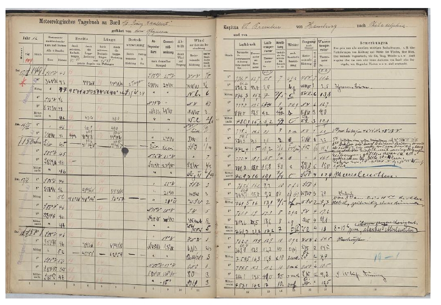
The next line in the log is the 8 a.m. observation, and the DR position is given as 41°51’N, 49°59’W and the course is given as S18°W. The difference between this DR position and the position calculated from the course changes described above is just over a mile. Since both locations can be considered approximations, the difference is negligible, and together they confirm that the vessel turned south at this time close to this point. Again, the legibility of the latitude 41°51’N in the log is not crystal clear and could be construed as 41°31’N, but this would be 20 miles south from the calculated position and does not conform with the overall descriptions. As if in final confirmation of the 41°51’N position are numbers written more faintly and a bit smaller just above the entries for latitude and longitude of 41.9 and 50.0 (Figure 4), which are the decimal degree equivalents of 41°51’N and 49°59’W respectively. Possibly these entries were made at a later date. The 8 a.m. log entry also has this ice observation in the ‘Remarks’ column (here in translation into English):
At 8 a.m. we met on both sides as far as visible an ice field of about 4 to 5 nm extension with large isolated icebergs, counting about 25. Dimensions 100 m long, height 30-40 m. Last ice seen lat. 41°37’N and long. 50°14’W.
However, an inconsistency remains with the times of the last two legs in the captain’s report. It is established that the turn to S18°W was made at 8 a.m. and the description states that 12 miles were run on this course when at 8:40 to 8:45 the ship turned to a more westerly course to go through the ice at a suitable point, reaching open water between 9:55 and 10 a.m. This is a total run of 19 nm which in 2 hours is 9.5 kt, which is reasonable, but the first leg of 12 nm was supposedly covered in 40 to 45 minutes, which is an impossible 16 -17 kt. The distance between the DR 4 a.m. and 8 a.m. positions is 44.8 nm which was thus travelled at 11.2 kt. Assuming the ship kept this speed on its S18°W course for 12 nm, that would have taken 1 hour 4 minutes until 9:04 approximately, leaving 50 minutes, or so, to travel the next 7-mile leg through the ice at a speed of about 8.4 kt which implies that the ice was fairly open. In fact, from the details given it would appear that on both occasions when speed was reduced, it was only marginally so, and the ship still proceeded at about three-quarters speed. The last 7 mile leg is also consistent with the comment in the meteorological log of the ice field being 4 to 5 nm wide.
Radio communication
It is worth noting that Captain Brambeer confirms that he had a working wireless radio on board the Prinz Adalbert; he received from the Caronia by wireless telegram a detailed ice report on April 14, 1912. He sent his own ice report of April 16 to the U.S. Hydrographic Office by a “radiogram”, the version appearing in Lloyd’s List 23 being dated New York, April 20 via Halifax, as the ship with its limited 250 mile nominal wireless range came within distance. The Titanic’s loss was all over the wireless radio reports out at sea on April 15th to 16th. In fact, the proces-verbal of the SS Baltic24 (official statement of radio communication) presented at the U.S. Senate Inquiry into the Titanic disaster, reveals that on the morning of April 15th the SS Californian was monopolizing the air waves to such an extent that they were effectively jamming radio traffic, and that at 11 a.m. it was still impossible to work the radio due to the Californian being in communication with the Prinz Adalbert.
So, we can be sure that everyone on board the Prinz Adalbert knew of the Titanic loss despite any language difficulties there might have been on a German-speaking vessel. Walter Lord said in his 1955 caption to the iceberg photo that:
“The Chief Steward of the German ship Prinz Adelbert[sic] took the picture, not because of the Titanic – he hadn’t yet heard – but because a great scar of red paint ran along the berg’s base. It suggested a recent collision with some ship. White Star vice president Philip A.S. Franklin was sufficiently impressed that he always refused to look at the picture.”
Walter Lord could not be correct on this matter. On the morning of Tuesday, April 16, 1912 the Chief Steward of the Prinz Adalbert, whoever he was, had most certainly, as a ship’s officer on the passenger vessel, heard of the loss of the Titanic a day-and-a-quarter earlier.
Conclusion
Clearly, as substantiated in the meteorological log and the statement by Capt. Brambeer to the Board of Trade, the Prinz Adalbert passed the Titanic area on April 16th, not the 15th as declared in Walter Lord’s book and which has been generally accepted ever since. Further, examination of the track in Figure 4 shows that the ship passed to the north of the Titanic site before turning south in search of open water, consequently staying to the west of the Titanic area. The deterioration of ice conditions over the preceding days from almost ice-free along the shipping lanes just a few days prior to the Titanic collision, to subsequent days of ice obstruction, demonstrate the swift onset of ice fields from the north flowing south with the Labrador Current. Certainly, the Prinz Alalbert passed very close to the Titanic collision site, a little over 4 nm when she passed to the north, and about 3.5 nm to the west while on her southerly track, and being to the westward also explains why no debris was reported as sighted by the vessel. It is also impossible to believe that an iceberg struck by the Titanic some 33 hours earlier would find itself to the north, or to the west, of its original location when it would quite likely be some 30 miles to the south. Hence the photograph shown in Lord’s book of an iceberg which has a “better pedigree than most” in sinking the Titanic is a claim that cannot be substantiated and the evidence we have shown points to it as being extremely unlikely.
Acknowledgments
The authors gratefully acknowledge the significant contribution to this article by John P. Eaton, and to the assistance of Joel Zemel of Halifax, Nova Scotia, in fact-finding in relation to Capt. Brambeer and the Prinz Adalbert and for pointing out to us the earlier posting by Dave Gittins; and the staff of the National Archives and Records Administration, College Park, Maryland, the Maritime Museum of the Atlantic in Halifax, Nova Scotia, Dalhousie University’s Killam Memorial Library in Halifax, the Maritime History Archive, Memorial University of Newfoundland, St. John’s, Newfoundland and Labrador, for their courteous and efficient services. The background bathymetric charts reproduced from the GEBCO world map 2013, www.gebco.net in Figures 2 – 4 is hereby acknowledged.
Endnotes
[1] Lord, Walter. 1955. A Night To Remember. Henry Holt and Company, New York City, New York, Library of Congress Catalogue Card No. 55-10643, 1st edition, November, 209 pp.; 3rd photograph following p. 94, Prinz Adelbert[sic = Adalbert], Chief Steward photograph of iceberg “near the scene on April 15″.
[2] www.newicedata.com
[3] National Archives at College Park, Record Group 287, Stack B190, Row 17, Compartments 5 and 6.
[4] http://www.paullee.com/titanic/ice.html accessed July 2013.
[5] http://www.titanicinquiry.org/ships/prinzadalbert.php accessed July 2013; drawn from John P. Eaton 2009 Profile of a Disaster Titanic-Related Ships 119: Prinz Adalbert. Voyage, Journal of the Titanic International Society, Inc., Freehold, New Jersey, Issue 70, Winter. p. 111.
[6] http://de.wikipedia.org/wiki/Prinz_Adalbert_(Schiff,_1903) accessed September 2013.
[7] New York Maritime Register. 10 April 1912. Weekly Compendium, p. 42; also Movements of Ocean Steamers for Philadelphia, p. 51.
[8] http://www.desena.com.br/arvore/desena/list_pass.htm accessed July 2013, as an example.
[9] The Call, San Francisco. 18 January 1909. Vol. 105, No. 49, via: http://cdnc.ucr.edu/cgi-bin/cdnc?a=d&d=SFC19090118.2.11# accessed July 2013, as an example.
[10] New York Times. 9 November 1905. Mafia Scare for Sailors. via: http://query.nytimes.com accessed July 2013, as an example.
[11] New York Herald. Thursday, 11 April 1912. Herald Cable Reports – Hamburg. p. 21, col. 5 (top).
[12] Lloyd’s List. 22 April 1912. Philadelphia. p. 11, col. 28; also 1 May 1912, Philadelphia, p. 5, col. 17.
[13] New York Herald. Sunday, April 21, 1912. American Ports – Philadelphia. Section 5, p. 3, col. 2 (middle).
[14] List or Manifest of Alien Passengers for the United States Immigration Officer at port of Arrival. Philadelphia. SS Prinz Adalbert. April 21 [1912]. via: http://archive.org/stream/passengerlistsof0101unit#page/n382/mode/1up accessed July 2013.
[15] Lloyd’s List. 8 April 1912. Dover. p. 9, col. 30.
[16] Lloyd’s List. 9 April 1912. Wireless Reports. p. 11, col. 26.
[17] http://www.encyclopedia-titanica.org/forums/collision-sinking-theories/9729-sketches-iceberg-2.html , 29 November 2003.
[18] http://www.encyclopedia-titanica.org/forums/collision-sinking-theories/9725-iceberg-4.html , 12 November 2006.
[19] http://www.encyclopedia-titanica.org/forums/general-titanica/14495-iceberg-did-our-lady.html , 7 March 2009.
[20] Reichenbächer, F.V. 1912. Letter-report, of mainly the words of Captain [Brambeer] of the SS Prinz Adalbert, addressed to the Assistant Secretary, Board of Trade. Marine Department, London, England. Hamburg-Amerika Linie, Nautische Abteilung. Hamburg, Germany, June 29, 2 pp. plus enclosure, April 14, 0135 wireless telegram copy, Deutsche Betriebsgesellschaft für Drahtlose Telegrafie M.B.H., field ice and iceberg report of April 12 from Captain Barr, SS Caronia, 1 p. in Public Record Office (now National Archives). 1999. TITANIC The True Story. Kew, Richmond, Surrey, England, ISBN 1-873162-78-2, booklet, 24 pp. and CD-ROM containing the 20 official Titanic files from the PRO comprising 8,717+ pp. The above letter-report found in Record Group MT 9/920E of 812 pp., Document M18975, pp. 421-425 (CD ROM files 431.TIFF-433.TIFF and 435.TIFF-436.TIFF; 434.TIFF is a duplicate of p. 423).
[21] Ruffman, Alan. 2000. The position of Titanic’s lifeboats on recovery. Voyage 33, Titanic International Society, Inc., Summer, pp. 42-43.
[22] Meteorologisches Tagebuch von Bord des HAPAG Dampfschiffes Prinz Adalbert,
Kapitän Brambeer, Reise von Hamburg nach Philadelphia im April 1912; Deutsche Seewarte; Meteorological log from HAPAG SS Prinz Adalbert, master Brambeer, from Hamburg to Philadelphia in April, 1912; archived by Deutscher Wetterdienst, Seewetteramt Hamburg.
[23] Lloyd’s List. 29 April 1912. Weather & Navigation. p. 9, col. 34.24“Titanic” Disaster. The Official Transcript of the United States Senate Hearings into the sinking of the RMS Titanic, April 19-May 25, 1912. Subcommittee of the Committee on Commerce, United States Senate, New York, N.Y.; Extract of Proces Verbal book, Marconi office, steamship Baltic, pp 1053, p. 1063.
[24] “Titanic” Disaster. The Official Transcript of the United States Senate Hearings into the sinking of the RMS Titanic, April 19-May 25, 1912. Subcommittee of the Committee on Commerce, United States Senate, New York, N.Y.; Extract of Proces Verbal book, Marconi office, steamship Baltic, pp 1053, p. 1063.