Ice from east coast and Gulf met so that the island was surrounded by ice. (AH).
Bark “Clutha” bound for Bahai, Brazil caught in heavy northern ice which caused her to leak. Crew picked up by schooner “Jean Campbell”. (FS).
Schooner “Gay Gordon” lost after being caught in field ice. (FS).
February
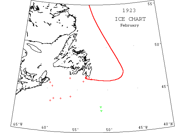
Feb 5 St. Paul’s Island: heavy close packed ice everywhere; Cape Ray and Flat Point: light open ice everywhere.
Feb 9 SS “Knud” from Louisburg to St. John, NB damage to forepeak by ice.
Feb 20 SS “Daghild” at St.John’s from Rotterdam had to feel her way through 500m of ice to get into port.
Feb 20 SS “Sagona” 6 days out from Port aux Basques is caught in an icefield 35m off Louisburg.
Feb 20 There is a heavy slob of ice along the south coast of Nova Scotia, extending about 10 miles off shore. From Brazil Rock, 4321’N 6526’W to 4316’N 6544’W, steamed through field ice from 4 to 6 inches thick.
Feb 21 Cape Ray: heavy close packed ice everywhere; Cape Race: slob ice, heavy, open.
Feb 23 Ship “A.B. Barteaux” left Perth Amboy, NY Feb 5 bound for St. John’s. 4 days into passage ran into ice in which she was held for more than a week. Reaching clearer water made good progress until the 20th when a pan of ice stove in the bow and she sank. The SS “Hauk” from Louisburg to St. John’s came across survivors in very tight ice off Cape Pine. (JPA)..
Feb 24 SS “Stanaker” 4537’N 4505’W, 11′ of water in the hold, abandoned Feb 27 in 4602’N 4323’W (no mention of ice).
Feb 24 SS “Pro Patria” from Halifax to St. Pierre caught in the ice 40m south of St. Pierre and seeking assistance.
Feb 26 SS “Rosalind” for St. John’s from Halifax making slow progress in heavy ice 85m SW of Cape Race. (arrived Feb 27).
Feb 26 SS “Sable Island” is jammed in the ice 30m SE of Cape Race, for St. John’s. (arrived Feb 27).
Feb 27 Small icebergs at, 4236’N 6205’W; heavy ice in area, 4320’N 5920’W, 4420’N 5600’W, 4329’N 5731’W, and 4321’N 5814’W; growlers and large berg, 4500’N 4555’W
Feb 28 A small dangerous berg, 4306’N 5109’W
Feb 28 At 4220’N 6550’W a field of slob ice 10 miles long by 5 miles wide was passed. Feb 28 SS “Sagona” still in heavy pack 75m SE of Scatari Island.
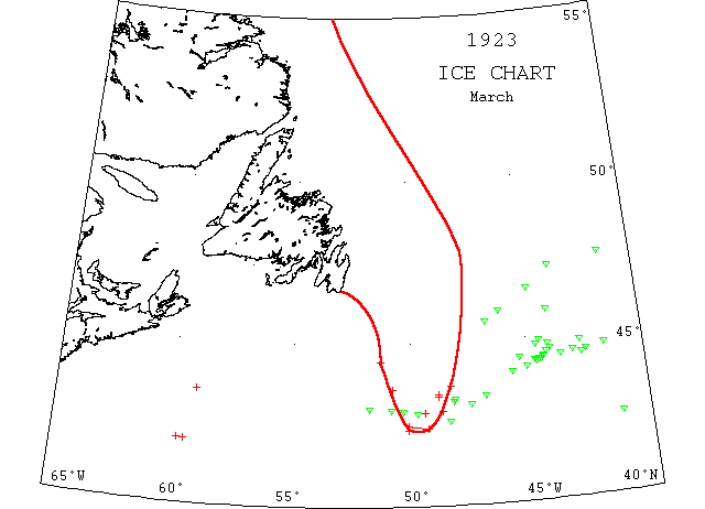
March
Mar 2 A furious blizzard raged in the St. John’s vicinity. driving the ice off the SW coast. It was hoped that coastal steamers would be able to move tomorrow and distribute provisions to isolated communities.
Mar 2 Canadian Government steamer “Stanley” from Louisburg for “Pro Patria” got stuck in the ice 50m ESE of Louisburg; Mar 4, “Stanley” picked up “Pro Patria” and being towed to St. Pierre, 3 blades of propeller and rudder gone.
Mar 2 Canadian Government ice breaker “Stanley”, which sailed form Louisburg yesterday in an attempt to reach the steamer “Pro Patria” disabled in the ice 70m from St. Pierre, wirelessed today that she herself had been caught in an ice field 50m ESE of Louisburg.
Mar 2 Offshore blizzard drove ice off the coast in the vicinity of St. John’s giving hope that the local steamers can go out.
Mar 2 Schooner “James O’Neil” crushed by ice off St. Pierre and sank.
Mar 3 Schooner “James O’Neill” from Gibralter to Harbour Grace caught in the ice 120m SSW half W of Cape Race and sunk. Crew rescued by SS “Belveman”. (FS).
Mar 5 Schooner “A B Barteaux” crew from, picked up by SS “Hawke”, badly frozen; from New York Feb 5, for St. John’s.
Mar 6 SS “Sinasta” SW limit of icefields 4223’N 6010’W extending to 4830’W and as far north as can be seen.
Mar 6 “Sinasta” reports SW limit of icefields 4223’N 6010’W extending easterly to 4830′(W?) as far north as can be seen.
Mar 8 4632’N 4135’W passed a growler; 4625’N 4138’W a berg surrounded with growlers and 4623’N 4134’W a berg surrounded with growlers.
Mar 9 St. John’s: The ice fields that have blocked the coast for weeks were breaking up today.
Mar 13 light slob ice off Halifax.
Mar 13 Schooner “Novelty” met drift ice 4355’N 54W. In ice for the next 8 days or so finally making Lunenberg on 5 April. (HDR).
Mar 13 2 medium sized bergs in 4442’N 4240’W; 4445’N 4250’W. Large berg in 4632’N 4447’W and numerous growlers between these positions; large berg 4320’N 4550’W; growlers 4642’N 4210’W; several Newfoundland schooners overdue probably caught in the ice and needing provisions.
Mar 14 4432’N 4302’W a large berg; 4416’N 4340’W a berg and 2 growlers.
Mar 15 SS “Rosalind” caught in heavy ice 40m off Cape Race from Halifax to St. John’s and unable to proceed. Mar 15 St. John’s: The sealing fleet which put out over a week ago is fast in heavy ice off the northern coast of Newfoundland. SS “Glencoe” has been icebound at d’Argent Bay on the south coast for nearly a month and SS “Argyle” at Burin for more than 2 weeks. Both are laden with provisions for many settlements along the coast, where people are in dire need for food. SS “Portia” on a similar errand of mercy was forced today to land provisions at the edge of the ice floe at various points in Fortune Bay.
Mar 15 Boston: “Tampa” sailed today for the ice patrol. She carries a new device utilizing sound waves to bring signals of the proximity of big bergs and has an aviator expert, who will make a study of atmospheric conditions as they bear on the berg problem.
Mar 15 “Seneca”: Icefield today in 43[possibly 45]20’N 4850’W; slob ice 4252’N 4925’W. Following bergs reported: 4442’N 4240’W; 4448’N 4240’W; 4320’N 4650’W & 4305’N 4730’W. Warning vessels to keep south of 42N between 50W and 47W, thence south of line from last position, extending through intersection of 41Α and 45N. Field ice everywhere east of Grand Banks from its tip to Flemish Cap. Heavy ice on Grand Banks from Cape Race to 4427’N 5116’W.
Mar 15 St. Paul’s Is., heavy close packed ice everywhere, moving SE; Cape Ray – heavy close packed ice everywhere moving south; Cape Race, heavy open ice everywhere, moving SE; Point Amour, heavy open ice everywhere, moving SE; Belle Isle, heavy close packed ice everywhere, 8 bergs; Eastern Harbour, ice still solid.
Mar 15 4330’N 5909’W large ice field and several growlers.
Mar 20 “Tampa” reports 3 bergs near 43N, west of Tail, apparently southernmost bergs. Searched south of Tail no ice; 23rd, ice field southern boundary reported today in 4336’N 5047’W; field ice and scattered bergs along E side of Banks to Flemish Cap to the eastward; 4430’N 4225’W, 3 bergs.
Mar 22 4334’N 5655’W a large icefield sighted extending 40m in a westerly direction and as far northward as could be seen.
Mar 22 SS “Belvernon” at Boston was damaged by ice between St. John’s via Halifax.
Mar 24 4340’N 4850’W southern edge of ice field.
Mar 27 Fishing schooner “William A Morse” at Halifax after collision with iceberg off Sable Island.
Mar 27 Cape Ray and Belle Isle: heavy close packed ice, distant
Mar 30 4424’N 4408’W a berg, 5 others within 16m radius; 4455’N 4410’W a berg; 4223’N 4940’W field ice.
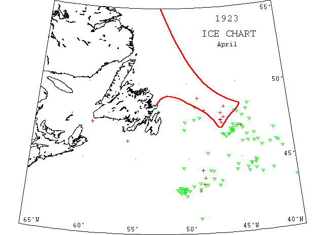
April
Apr 1 4350’N 48W a berg.
Apr 16 Barkentine “Clutha” from St. John’s to Bahia wrecked by ice in 41N 47W. (PR).
Apr 23 Large ice field 4758’N 4656’W and 4730’N 4655’W with numerous bergs to westward. Ice field extends from Cape Breton coast to 45N 54W thence northward over St. Pierre Banks.
Apr 24 SS (French fishing schooner) “Le Raymond” 4857’N 4755’W hit berg and sank. (IIP59).
Apr 25 SS “(France) Et Bretagne” 4615’N 4405’W hit berg and sank. (IIP59).
Apr 27 SS “Cymric Queen” hemmed in by ice 4535’N 6035’W
Apr 30 Boundary field ice line 48N 45W to 4720’N 4640’W thence 48N 49W. North of this line many bergs and growlers lodged in field ice.