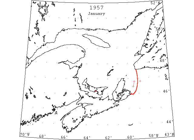
Jan On 31 January, Cabot Strait was reported blocked by field ice extending east from the Strait to longitude 45°W and south to latitude 46°N (IIP p7)
Jan 2 Three draggers docked at Souris at 8:30 Tuesday night. Fought way in from Gulf of St. Lawrence in a blizzard. (Pat 4 Jan p3 c3)
Jan 4 The good old icebreaker “Saurel” left port this morning heading for Halifax. Had it slow getting through river ice to harbour; that about settles our “ocean” traffic to this port (Charlottetown) for present. (Pat 4 Jan 1957, p4 c4)
Jan 7 46°48’N 59°24’W to 46°27’N 59°32’W Broken field ice (IIP p12 #11)
Jan 11 MV “Maid of Lehave” loaded potatoes at Georgetown. (Pat 11 Jan p5 c5)
Jan 29 From Scatari Island to 45°57’N 59°34’W Loose Pancake ice. (IIP p12 #24)
Jan 29 Strings of pancake ice 46°48’N 58°50’W. (IIP p12 #25)
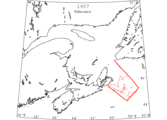
Feb A large area of close pack encumbered Cabot Strait and its approaches throughout the month from 45°40’N, 60°20’W to 44°40’N 58°00’W to 45°20’N 57°00’W to 10 miles off Cape Ray. (IIP p7)
Feb 4 M/V “Petit Bras D’or” from Sydney to St. Pierre hit berg 48 m E of Cape Breton and sank. (IIP59).
Feb 9 45°38’N 58°30’W to 45°26’N 58°30’W Field ice (IIP p13 #95)
Feb 14 From 45°00’N 57°20’W to 45°00’N 58°00’W and northward Strings of brash ice. (IIP p14 #110)
Feb 14 45°15’N 59°40’W and 5 miles to NE and SW Loose field ice with pieces up to 4 feet thick. (IIP p14 #112)
Feb 20 From 45°37’N 58°33’W to 45°21’N 58°37’W to 45°10’N 59°20’W Scattered field ice. (IIP p15 #163)
Feb 21 From 46°15’N 58°10’W to 46°05’N 58°40’W to 46°15’N 58°50’W 46°15’N 58°56’W to 46°00’N 59°00’W to 45°45’N 59°15’W to 45°30’N 59°15’W to 45°40’N 59°35’W to 45°40’N 60°00’W to 45°30’N 60°15’W Pack boundary (IIP p15 #177)
Feb 22 45°16’N 58°31’W Very heavy field ice. (IIP p16 #179)
45°29’N 58°10’W Scattered patches slob ice, rafted pieces. (IIP p16 #180)
From 45°23’N 58°29’W to 45°22’N 58°36’W to 45°01’N 58°55’W Heavily rafted ice. (IIP p16 #183)
Feb 25 44°55’N 58°06’W to 44°22’N 58°18’W Field ice (IIP p16 #213)
Feb 26 Northerly direction from 45°15’N 58°20’W Light field ice. (IIP p17 #240)
North and south from 45°22’N 57°41’W Strings slob ice. (IIP p17 #241)
SE and NNW from 45°21’N 57°46’W Light field ice. (IIP p17 #242)
West from 45°07’N 58°55’W Strings loose field ice. (IIP p17 #243)
South of line from 45°02’N 58°44’W to 45°12’N 58°37’W Field ice with thick pieces (IIP p17 #244)
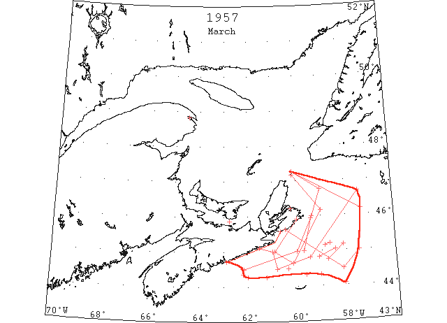
March A considerable area off the east coast of Nova Scotia remained covered with field ice throughout the month. The off-shore limits of this pack generally lay within 75 miles south, east, and north of Cape Breton. The steamer track from Cabot Strait to Gaspé Passage was not navigable in March. However, the northwestern half was almost clear of ice by the last of the month, and the pack in the remainder of the track was breaking up rapidly. (IIP p7)
Mar 1 44°45’N 58°45’W to 45°10’N 58°08’W Southern limits field ice. (IIP p17 #276)
Mar 7 Can. DOT: Southern field ice limits, Cabot Strait, 44°20’N 59°05’W. (IIP p19 #368)
Mar 8 44°20’N 59°40’W Field ice (IIP p19 #394)
Mar 8 44°04’N 58°06’W Field ice (IIP p19 #395)
Mar 8 Steamer track Cabot Strait to Gaspé Passage Field ice, 90 % cover. (IIP p19 #396)
Mar 8 Can. DOT: Field ice limits from St. Paul Island to 46°10’N 57°20’W to 45°00’N 57°30’W to 44°30’N 58°10’W to St. Esprit Island. (IIP p19 #397)
Mar 13 Between 44°49’N 59°08’W and 45°03’N 58°27’W Field ice. (IIP p20 #451)
Mar 13 Michaux Point to Cranberry Island Heavy close pack. (IIP p20 #453)
Mar 16 Some improvement in ice conditions in mouth of St. Lawrence River. (Pat 16 Mar p4 c5)
Mar 17 St. Paul Island to 46°45’N 59°00’W to 46°00’N 59°22’W to 45°00’N 60°00’W to 44°30’N 62°10’W Field ice limits. (IIP p21 #485)
Mar 20 Country Island to 45°00’N 61°00’W to 44°30’N 60°50’W to 44°50’N 59°30’W to 46°40’N 57°25’W to St. Paul Island Field ice limits. (IIP p21 #514)
Mar 20 Steamer track from Cabot Strait to Gaspé Passage. Field ice, 80% cover. (IIP p21 #515)
Mar 24 44°31’N 62°13’W to 44°21’N 62°12’W Close heavy pack. (IIP p22 #543)
Mar 26 44°16’N 61°15’W to 44°16’N 62°00’W Partial southern limits field ice. (IIP p22 #572)
Mar 27 45°00’N 59°43’W to 45°56’W 59°24’W Field ice. (IIP p23 #590)
Mar 27 45°09’N 58°52’W to 45°13’N 58°40’W Field ice. (IIP p23 #591)
Mat 28 From 45°55’N 60°00’W 45°00’N 60°55’W to 44°40’N 60°10’W to 46°10’N 59°00’W to 47°10 60°10’W Field ice limits. (IIP p23 #603)
Mar 29 An ice barrier 60 miles wide extends across the steamer track between Cabot Strait and the mouth of the St. Lawrence River. Still open water off west coast of Newfoundland; ice along southern section of Cabot Strait and along north and east side of Cape Breton Island. Sydney harbour is closed. Northumberland Strait still choked with ice. (Pat 29 Mar p1 c6)
Mar 30 44°30’N 60°22’W Field ice. (IIP p24 #662)
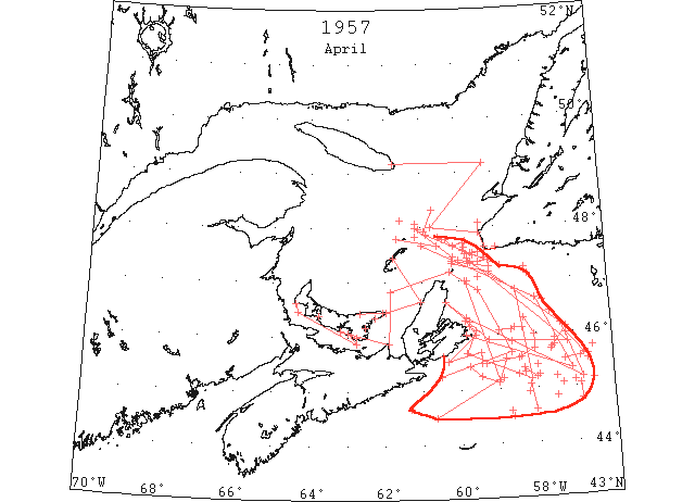
April The steamer track upriver from the northeast part of the Gulf of St. Lawrence was essentially free of ice on 1 April, but navigation on the track was hampered to a considerable degree by large masses of drifting ice until the end of the month. A belt of field ice about 60 miles wide encumbered the entire east coast of Cape Breton Island during all of April. The first ship to make passage from the Cabot Strait to Montreal arrived on 1 Apr. (IIP p8)
Apr 2 From 47°00’N 59°50’W to 45°10’N 59°00’W 44°30’N 60°40’W to 44°40’N 61°20’W Field ice limits. (IIP p25 #731)
Apr 4 Ice conditions in Gulf of St. Lawrence not good. Slight improvement in Strait from West Point to Point Prim, but Point Prim to Wood Islands showed 80% coverage. Heavy ice found along west coast of Cape Breton to Magdalene Islands and East Point of P.E.I. showing heavy pressure in places. (Pat 4 Apr p4 c7)
Apr 5 “Italia” field ice 44°30’N 58°40’W. (IIP p25 #741)
Apr 6 Between 45°12’N 58°00’W and 45°22’N 58°20’W Patches of field ice. (IIP p25 #755)
Apr 6 44°36’N 58°42’W Field ice. (IIP p25 #756)
Apr 6 44°36’N 58°04’W to 45°04’N 58°12’W Field ice. (IIP p13 #757)
Apr 6 45°12’N 58°54’W Field ice. (IIP p25 #759)
Apr 7 Line from 46°16’N 59°52’W to 46°00’N 59°35’W to 45°32’N 60°19’W to 45°40’N 59°27’W to 45°29’N 59°27’W to 45°29’N 59°20’W to 45°34’N 58°28’W to 45°44’N 58°03’W to 45°59’N 58°03’W to 46°18’N 58°19’W Field ice limits. (IIP p26 #763)
Apr 8 45°25’N 58°00’W Strings field ice. (IIP p13 #766)
Apr 8 47°04’N 59°28’W and to south and southwest. Field ice (IIP p26 #767)
From 46°07’N 58°21’W to 46°07’N 58°34’W to 46°05’N 58°39’W to 46°05’N 58°58’W Field ice (IIP p26 #768)
Apr 8 Line from 47°20’N 59°40’W to 46°50’N 58°30’W to 45°10’N 58°10’W to 45°40’N 59°50’W to 46°05’N 59°35’W to 46°10’N 59°45’W to 46°15’N 59°45’W Field ice limits. (IIP p26 #769)
Apr 9 Government ice breakers continued to butt heavy Gulf ice today in an attempt to free 7 jammed ships, caught in ice 20 feet thick. (Pat 9 Apr p3 c4)
Apr 12 14 miles north of Bird Rock Heavy field ice (IIP p27 #798)
Apr 12 48°08’N 61°35’W and northward. (IIP p27 #799)
Apr 12 Cape Ray and westward. Strings of slob ice. (IIP p27 #800)
Apr 12 Line from 47°25’N 59°45’W to 45°50’N 57°10’W to 45°55’N 59°15’W to Cape Smoky. (IIP p27 #801)
Apr 13 45°54’N 57°31’W Field ice. (IIP p27 #812)
Apr 13 45°45’N 57°36’W Field ice. (IIP p27 #813)
Apr 13 “Prins Frederic Willem” scattered field ice 47°31’N 59°36’W. (IIP p27 #815)
Apr 13 Conditions improved. North Shore from North Point to Tracadie Harbour is clear but for harbours and bays. Northumberland Strait from St. Peter’s Island east to Cape George 70% coverage. (Pat 13 Apr p3 c3)
Apr 16 Line from 47°20’N 60°10’W to 47°10’N 59°10’W to 46°10’N 57°20’W to 45°10’N 56°50’W to 46°20’N 59°50’W to Cape Smokey. Field ice limits. (IIP p28 #843)
Apr 16 St. Peter’s Bay west around coast to Charlottetown Harbour practically clear. St. Peter’s Bay east to North Lake Harbour there is a strip of heavy ice along coast. (Pat 16 Apr p10 c1)
Apr 17 From 46°06’N 57°12’W to 45°42’N 57°37’W Field ice. (IIP p28 #872)
Apr 17 46°24’N 57°37’W Field ice. (IIP p28 #873)
Apr 17 46°37’N 57°48’W Ice floe. (IIP p28 #875)
Apr 17 47°13’N 58°13’W and to N and S (IIP p28 #876)
Apr 17 From 47°49’N 60°32’W to 47°47’N 60°20’W to 47°39’N 60°07’W to 47°42’N 59°51’W to 47°37’N 59°50’W Southern field limits. (IIP p28 #877)
Apr 18 45°18’N 57°20’W Field ice. (IIP p29 #889)
Apr 18 Line from 45°59’N 57°13’W to 45°36’N 56°46’W to 45°33’N 56°51’W to 45°30’N 57°17’W Southeast limits
Apr 18 field ice. (IIP p29 #890)
Apr 18 47°06’N 58°10’W Field ice. (IIP p29 #891)
Apr 19 Between Cape Anguille and Cape Ray and 10 miles northward. Field ice. (IIP p29 #915)
Apr 19 Vicinity of Bird Rock Heavy pieced field ice (IIP p29 #917)
Apr 19 Block House light (Charlottetown) is back on. (Pat 19 Apr p4 c3)
Apr 20 47°23’N 60°08’W to 47°16’N 59°11’W Northern limit field ice. (IIP p29 #920)
Apr 20 47°20’N 59°44’W String of field ice (IIP p29 #921)
Apr 20 45°35’N 56°40’W Field ice. (IIP p29 #922)
Apr 20 47°31’N 59°39’W to 47°32’N 59°27’W Field ice. (IIP p29 #923)
Apr 20 45°52’N 58°39’W Field ice (IIP p29 #924)
Apr 20 45°43’N 56°31’W Field ice. (IIP p29 #925)
Apr 20 45°30’N 56°40’W Eastern limit field ice. (IIP p29 #926)
Apr 20 Most P.E.I. bays still frozen with board ice clinging to most sections of Island coastline. Charlottetown only Island harbour open. Souris and Georgetown still blocked with ice, while Summerside has an ice barrier at entrance. (Pat 20 Apr p8 c3)
Apr 21 From 47°23’N 59°12’W to 47°21’N 59°29’W to 47°23’N 60°00’W Field ice. (IIP p30 #932)
Apr 22 Cape Ray to 47°40’N 59°35’W and to NNW Field ice. (IIP p30 #936)
Apr 23 45°12’N 57°30’W Southeast corner of field ice (IIP p30 #972)
Apr 23 45°35’N 58°25’W Field ice (IIP p30 #973)
Apr 23 Cape Ray to 47°25’N 59°19’W Strings field ice. (IIP p30 #974)
Apr 23 Cape Ray to Cape Anguille and northward. Belt of field ice 5 miles wide (IIP p30 #975)
Apr 23 45°15’N 57°57’W and northward Field ice (IIP p30 #976)
Apr 23 45°07’N 57°02’W and to north and west Field ice. (IIP p30 #977)
Apr 23 From 47°40’N 61°00’W to 46°40’N 58°00’W to 45°20’N 57°05’W to 46°00’N 59°50’W Field ice limits. (IIP p30 #978)
Apr 24 45°46’N 57°32’W Field ice (IIP p31 #986)
Apr 24 45°07’N 56°32’W Field ice. (IIP p31 #987)
Apr 24 South from Cape Ray 12 miles. (IIP p13 #988)
Apr 24 From 45°03’N 56°54’W to 44°46’N 56°52’W Light field ice. (IIP p31 #989)
Apr 24 From 47°34’N 59°53’W to 47°28’N 59°37’W Field ice. (IIP p31 #1038)
Apr 24 Charlottetown and Georgetown open. Gulf open to ships. (Pat 24 Apr p3 c3)
Apr 25 44°50’N 57°30’W Field ice. (IIP p32 #1053)
Apr 26 8 miles ENE Bird Rock Field ice. (IIP p31 #1057)
Apr 26 19 miles NE St. Paul Island (IIP p32 #1058)
Apr 26 “Tongariro” field ice 45°05’N 57°20’W. (IIP p32 #1067)
Apr 27 From 47°56’N 60°55’W ENE to horizon Field ice. (IIP p33 #1100)
Apr 27 44°56’N 58°14’W Field ice (IIP p33 #1103)
Apr 28 From 47°48’N 61°40’W to 47°40’N 60°35’W Field ice. (IIP p33 #1124)
Apr 28 From 47°52’N 60°52’W to 47°17’N 59°52’W Field ice. (IIP p33 #1125)
Apr 28 USNS “J.E. Kelly” field ice from Cape Anguille extending 25 miles SW. (IIP p33 #1126)
Apr 28 “John Lyras” field ice 47°46’N 60°25’W. (IIP p33 #1127)
Apr 28 “John Lyras” field ice 47°45’N 59°48’W. (IIP p33 #1128)
Apr 29 From 45°25’N 59°45’W to 45°14’N 59°27’W to 45°08’N 59°00’W to 45°33’N 58°48’W Field ice boundary (IIP p33 #1137)
Apr 29 47°23’N 60°10’W Field ice. (IIP p33 #1138)
Apr 29 10 miles north Bird Rock to 5 miles north St. Paul Island. (IIP p33 #1139)
Apr 29 From Cape George to 46°50’N 61°50’W to 47°10’N 60°15’W to 46°50’N 59°30’W to 45°40’N 58°40’W to 45°15’N 60°30’W to St. Esprit Islands Field ice limits. (IIP p34 #1140)
Apr 29 Cape Anguille to 48°00’N 60°45’W to 49°10’N 59°15’W and westward to coast. Field ice limits. (IIP p34 #1141)
Apr 30 47°00’N 59°46’W Southeast edge of field ice. (IIP p34 #1145)
Apr 30 “Italia” field ice 45°16’N 58°30’W. (IIP p34 #1148)
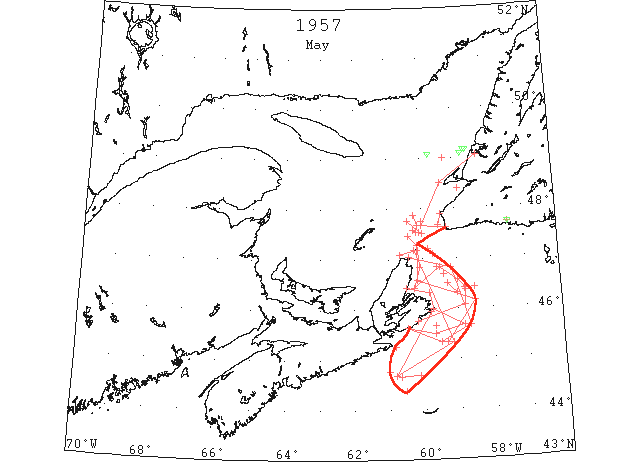
May The east coast of Cape Breton Island was encumbered by a belt of heavy pack ice averaging about 40 miles wide during the first 2 weeks of the month, but by the 19th this pack had disappeared except for scattered strings and patches. (IIP p9)
May 1 Cape Aguille to 47°40’N 59°30’W and to westward. Southern limits field ice. (IIP p34 #1157)
May 2 Between St. Paul Island and Cape Ray Scattered field ice. (IIP p34 #1166)
May 3 “Obuasi” growlers, scattered field ice 46°42’N 59°23’W. (IIP p34 #1181)
May 4 47°45’N 60°25’W to 47°30’W 60°00’W Field ice. (IIP p35 #1205)
May 4 47°32’N 60°11’W Heavy pieces field ice. (IIP p35 #1206)
May 4 47°34’N 60°15’W to 47°32’N 60°04’W Field ice. (IIP p35 #1207)
May 4 44°40’N 60°09’W to 44°39’N 60°40’W Field ice, moderately packed (IIP p35 #1208)
May 4 From 47°10’N 60°15’W to 45°20’N 59°10’W to 44°40’N 60°50’W to Cape Breton. Field ice limits. (IIP p35 #1209)
May 5 45°15’N 60°50’W and eastward. Field ice. (IIP p35 #1220)
May 6 44°45’N 61°00’W Field ice. (IIP p35 #1327)
May 6 47°12’N 59°49’W and to northward. Patches field ice. (IIP p36 #1328)
May 7 44°22’N 60°33’W Southern limit field ice. (IIP p37 #1346)
May 8 Unidentified vessel, scattered field ice 46°23’N 58°46’W. (IIP p37 #1369)
May 8 47°21’N 59°57’W Field ice. (IIP p37 #1370)
May 8 From 45°45’N 60°10’W to 46°05’N 58°48’W to 46°25’N 58°48’W to 46°25’N 58°48’W to 46°35’N 59°00’W to 46°50’N 59°30’W to 46°25’N 60°15’W to 46°50’N 60°05’W to St. Paul Island to northwest Field ice limits. (IIP p37 #1371)
May 8 From 47°05’N 60°40’to 47°10’N 60°10’W to 46°35’N 60°10’W to 46°10’N 58°30’W to 45°20’N 59°20’W
May 8 Field ice limits. (IIP p37 #1372)
May 8 From Cape Ray to 47°40’N 60°00’W to 48°30’N 59°25’W to Bay of Islands Field ice limits. (IIP p37 #1373)
May 9 47°45’N 60°00’W and northward Field ice (IIP p37 #1389)
May 9 47°06’N 59°42’W Field ice. (IIP p37 #1394)
May 9 46°25’N 58°31’W Field ice. (IIP p34 #1395)
May 9 47°41’N 60°07’W to 47°53’N 60°14’W Field ice. (IIP p37 #1396)
May10 47°42’N 57°27’W Berg and growlers. (IIP p38 #1406)
May10 46°09’N 58°22’W Field ice. (IIP p38 #1414)
May 11 49°00’N 59°17’W Field ice. (IIP p38#1445)
May 11 From Money Point to 46°50’N 59°10’W to 45°40’N 58°40’W to 45°20’N 59°30’W to St. Esprit Island (IIP p39 #1447)
May 13 46°20’N 59°00’W to 46°30’N 59°17’W Loose field ice. (IIP p39 #1485)
May 15 St. George Bay Scattered field ice. (IIP p37 #1569)
May 15 From St. Esprit Island to 45°30’N 59°40’W to 45°40’N 58°50’W Cape Breton ice limits to Scatari Island to 46°20’N 59°50’W to 46°25’N 60°30’W Cape Breton Ice limits. (IIP p40-41 #1570)
May 16 45°50’N 59°35’W Scattered field ice (IIP p41 #1581)
May 18 The last [ice reconnaissance] flight of the season was made. … “Conditions were much worse in 1957” reports Captain [A.] Brown [ice information officer, Marine Branch, D.O.T.]. “I made my last flight the 18th of May.” (Pat 27 Apr 1959 p3 c2)
May 19 Vicinity of 45°40’N 59°40’W Scattered field ice. (IIP p43 #1744)
May 22 49°05’N 59°45’W Berg (IIP p45 #1883)
May 29 49°05’N 58°46’W Berg. (IIP p49 #2108)
May 31 49°09’N 58°36’W Berg. (IIP p50 #2197)
May 31 49°10’N 58°40’W Berg., (IIP p50 #2198)