1956 Season
Dec 2 “C.D. Howe” left port (Charlottetown) this morning, possibly her last trip. (Pat 2 Dec p4 c3)
Dec 14 Last eastbound steamer through the Strait of Belle Isle. (WBB)
Dec 18 Last departure of the season from Quebec. (WBB)

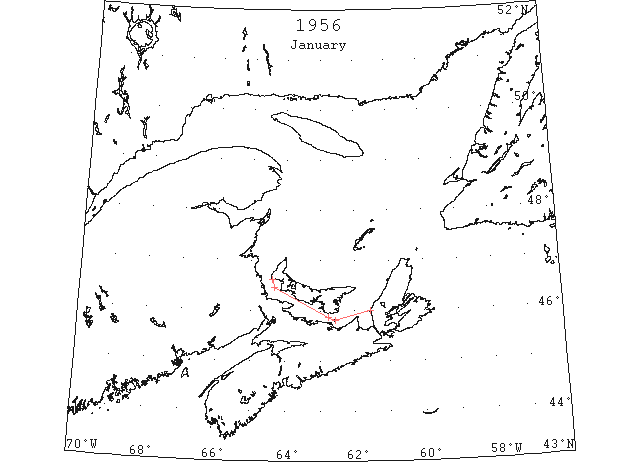
Jan 1 Icebreaker “N.B. MacLean” arrived in port yesterday to take out freighter “Mexico”. “MacLean” reported very heavy ice. Straits are reported full of ice from West Point to Cape Breton. (Pat 2 Jan p4 c3)

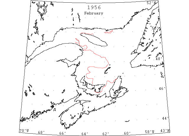
No additional textual records available.

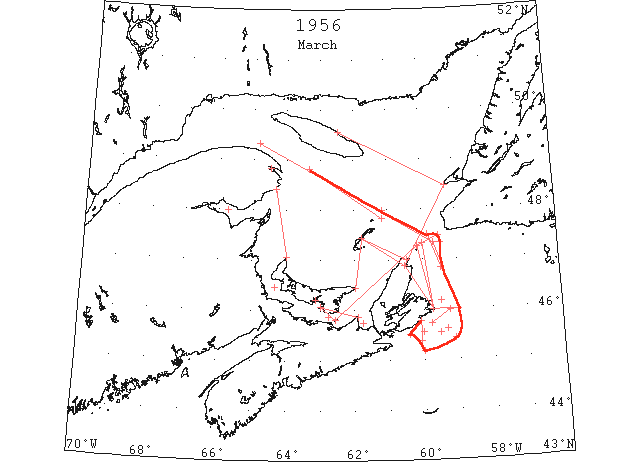
Mar In the Gulf of St. Lawrence area, the steamer track from Cabot Strait to the Gaspe Passage was navigable with caution during the last 10 days of March. Considerable pack persisted throughout the month to the southwest of this track in the Gulf of St. Lawrence, the western part of Cabot Strait and in the St. Lawrence River. (IIP, P5)
Mar 2 Ice Patrol – Ice in Gulf of St. Lawrence appeared to be very light. While in Northumberland Strait from Cape George to Pt. Prim, ice is quite heavy. West of Strait is filled with large amount of drift ice and some sheet ice. In Gulf a number of stretches of open water were seen. (Pat 2 Mar p4 c4)
Mar 11 46°10’N 59°29’W. Ice field, 1 mile by 2 miles. (IIP, P8 #13).
From 46°50’N 59°29’W to 47°20’N 59°29’W. Field of pancake ice. (IIP, P8 #14).
Mar 16 Area bounded by a line from Cape North to Scatari Island to 46°00’N 59°00’W to 47°30’N 59°50’W. Many belts and patches heavy field ice. (IIP, P8 #24).
Mar 19 45°10’N 60°00’W. 3 small patches of light field ice. (IIP, P8 #39).
Mar 19 “Fort Avalon” small patches light slob ice vicinity Cape Breton Island as far south as 45°30’N. (IIP p8 #46)
Mar 21 From east coast Cape Breton Island to a line from St. Paul Island to Scatari Island. Field of close pack. (IIP, P9 #62).
Mar 21 To seaward of line from St. Paul Island to Scatari Island and inside a line from St. Paul Island to 47°29’N 59°32’W to 46°07’N 59°00’W to 45°23’N 60°05’W to 45°47’N 60°05’W. Many strings and patches slob ice and brash. (IIP, P9 #63).
Mar 21 Northumberland Strait. 70 percent cover. (IIP, P9 #67).
Mar 21 Bird Rocks to 48°50’N 63°20’W. Clear. (IIP, P9 #68).
Mar 21 Gulf south of line in #68 70% cover. (IIP, P8 #69)
Mar 21 Chaleur Bay. 100 percent cover. (IIP, P9 #70).
Mar 21 George Bay. 100 percent cover. (IIP, P9 #71).
Mar 21 Magdalen Islands to Cape Breton Islands. 90 percent cover. (IIP, P9 #72).
Mar 24 From east coast Cape Breton Island to a line from 47°20’N 60°00’W to Scatari Island. Field of close pack. (IIP, P10 #116).
Mar 24 Within 20 miles coastline between Scatari Island and Fourchu Bay. A few scattered strings of ice. (IIP, P10 #117).
Mar 26 Northumberland Strait. 75 percent cover. (IIP, P10 #127).
Mar 26 Clear west of line from North Point to Cape d’Espoir. (IIP, P10 #128).
Mar 26 Gaspe Passage. Loose drift. (IIP, P10 #129).
Mar 26 SW of a line from 49°20’N 64°30’W to 47°20’N 59°40’W. Loose drift. (IIP, P10 #130).
Mar 26 NE above line in #130 to end of 30 miles visibility, clear. (IIP p10 #131)
Mar 26 Off west coast Cape Breton Island to a line from Magdalen Islands to East Point. 90 percent cover. (IIP, P10 #132).
Mar 26 Off east coast Cape Breton Island to a line from 47°20’N 59°40’W to 46°00’N 59°00’W. 60 percent cover. (IIP, P10 #133).
Mar 28 45°26’N 59°06’W. Strings of scattered field ice. (IIP, P10 #137).
Mar 30 45°37’N 59°20’W. Scattered strings field ice. (IIP, P11 #146).
Mar 30 Northumberland Strait. 70 percent cover. (IIP, P11 #150).
Mar 30 Inside a line from Cape Bear [Cap de l’Ours, Anticosti?] to Cape[St?] George to Cape North to Magdalen Islands. Close pack. (IIP, P11 #151).
Mar 30 Steamer track from 10 miles north of Bird Rocks to 49°30’N 64°40’W. Isolated pieces. (IIP, P11 #152).
Mar 31 In lat. 45°33’N. Between longs. 59°32’W and 60°00’W. Heavy packed slush ice. (IIP, P11 #154)
Mar 31 Heavy masses of board ice from Point Prim down to St. Paul’s Island. Area north of Canso Causeway completely covered. Heavy ice extends north to Magdalene Islands. Charlottetown Harbour clearing fast but ice conditions in North Strait more severe than usual and may be slow clearing. (Pat 31 Mar p1 c6)

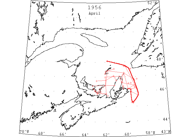
Apr Except for some isolated pieces of pack ice, the steamer track from Cabot Strait to Gaspe Passage and up river was clear by 4 April. By the end of the month the heavy pack to the southwest of this track disappeared except for some scattered pack off the east and west coasts of Cape Breton Island. (IIP, P5)
Apr 1 First arrival of season at Quebec. (WBB)
Apr 2 46°30’N 58°52’W. Field ice. (IIP, P11 #158).
Apr 2 46°45’N 59°07’W. Field ice. (IIP, P11 #159).
Apr 4 Northward of a line from 45°18’N 59°20’W to 45°18’N 59°23’W. Loose field ice. (IIP, P11 #166).
Apr 4 Northumberland Straits. 70 percent cover. (IIP, P11 #182).
Apr 4 George Bay. 90 percent cover. (IIP, P11 #183).
Apr 4 Line from 10 miles east of Scatari Island to 45°45’N 58°50’W to 46°50’N 59°10’W to St. Paul Islands. Outside limits field ice. (IIP, P11 #184).
Apr 4 Along west coast Cape Breton Island from St. Paul Island to Magdalens to Prince Edward Island to Cape George. Large body field ice. (IIP, P11 #185).
Apr 4 From 20 miles southeast Brion Island around north coast Magdalens to Amherst Island. Close packed field ice. (IIP, P12 #186).
Apr 4 Steamer track up St. Lawrence River. Clear except for isolated pieces. (IIP, P12 #188).
Apr 5 Northward of a line from 45°15’N 59°20’W to 45°16’N 59°27’W. Loose field ice. (IIP, P12 #195).
Apr 5 Northward of a line from 45°15’N 59°21’W to 45°17’N 59°27’W. Loose field ice. (IIP, P12 #196).
Apr 6 From 47°44’N 60°08’W to south-southeast to limit of visibility. Field ice. (IIP, P12 #197).
Apr 7 Northumberland Straits. 50 percent cover. (IIP, P12 #200).
Apr 7 Wood Island to East Point to Cape George. 60 percent cover. (IIP, P12 #201).
Apr 7 George Bay. 80 percent cover. (IIP, P12 #202).
Apr 7 West coast Cape Breton Island. Large body of ice. (IIP, P12 #203).
Apr 7 From 13 miles northeast Scatari Island to 46°15’N 59°00’W to 47°45’N 60°00’W. Very loose ice. (IIP, P12 #204).
Apr 7 South of a line from 47°45’N 60°00’W to 48°05’N 61°45’W. Drift ice. (IIP, P12 #205).
Apr 7 From 48°05’N 61°45’W westward and to Grindstone. Many small fields. (IIP, P12 #206).
Apr 7 Mount of Chaleur Bay. Large field. (IIP, P12 # 207)
Apr 9 Ice open to Point Prim, after that East it is chock a bloc. (Pat 9 Apr p4 c3)
Apr 10 Georgetown Harbour is opening up gradually. (Pat 10 Apr p6 c7)
Apr 11 Steamer track, Cabot Strait to Gaspe Passage. Clear, except isolated pieces. (IIP, P13 #230).
Apr 11 From Cape North to Sydney Harbor. String of close pack ice 3 to 8 miles wide. (IIP, P13 #231).
Apr 11 Along Cape Breton west coast. Large body heavy ice. (IIP, P13 #238).
Apr 11 Steamer track, Cabot Strait to Gaspe Passage. Clear of ice. (IIP, P13 #239)
Apr 12 Heavy ice persists between Rustico and East Point. Water wide open elsewhere. (Pat 12 Apr p1 c6)
Apr 17 Charlottetown entrance to East Point to Cape George. Scattered strings heavy ice. (IIP, P14 #270).
Apr 17 George Bay. 60 percent cover. (IIP, P14 #271).
Apr 17 West coast Cape Breton Island to White Capes to 47°05’N 61°10’W to 20 miles north of East Point. Loose drift. (IIP, P14 #272).
Apr 17 From above position to 20 miles off Savage Harbor. Heavy drift. (IIP, P14 #273).
Apr 17 Steamer track, Cabot Strait to Gaspe Passage. Clear of ice. (IIP, P14 #274).
Apr 17 30 miles northeast of Sydney Harbor. Scattered fields of heavy drift. (IIP, P14 #275).
Apr 19 Vicinity of 46°18’N 59°07’W and westward. Ice field 5 miles wide. (IIP, P14 #276).
Apr 19 46°35’N 59°30’W. Dense ice field. (IIP, P14 #277).
Apr 19 George Bay. 60 percent cover of heavy drift ice. (IIP, P14 #278).
Apr 19 Inside a line from Flint Island to 46°25’N 59°10’W to Cape Smoky. 40 percent cover of heavy drift ice. (IIP, P14 #279).
Apr 19 Inside a line from Cape St. Lawrence to 47°00’N 62°00’W to East Point to Cape Breton Island coast. 60 percent cover of heavy drift ice. (IIP, P14 #280)
Apr 20 Charlottetown Harbour temporarily closed due to large sheet of ice. Point Prim to Wood Islands drift ice on Island side. Wood Islands to Cape Bear – ice heavy along Island shore. (Pat 20 Apr p1 c3)
Apr 24 Area between Flint Island and St. Paul Island. Scattered fields of loose drift ice. (IIP, P14 #285).
Apr 24 Along west coast Cape Breton Island. Body of heavy drift ice. (IIP, P15 #286).
Apr 28 From Ingonish Island to 47°08’N 60°15’W. Field ice. (IIP, P16 #372).
Apr 28 Inshore from Sydney Harbor entrance north to lat. 46°23’N. Field ice. (IIP. P16 #373).
Apr 29 West coast Cape Breton Island. Some loose drift. (IIP, P16 #381).
Apr 29 From Flint Island to St. Paul Island. Scattered fields loose drift. (IIP, P16 #382).
Apr 29 Steamer track, Cabot Straits to Gaspe Passage. Clear of ice. (IIP, P16 #383)
Apr 30 Imperial Toronto (tanker) in Charlottetown. (Pat 30 Apr p1 c2)
Apr 30 Harbour at Souris is now ice free. (Pat 30 Apr p6 c4)
May 1 Last DOT flight of the season. (Pat 27 Apr 1959 p3 c2)
May 9 51°06’N 57°23’W. Berg. (IIP, P19 #599).
May 9 51°14’N 57°07’W. Berg. (IIP, P19 #600).
May 9 51°18’N 57°12’W. Berg. (IIP, P19 #602).
May 16 Cape Bauld to Chateau Bay. Western limit field ice. (IIP, P22 #777).
Jun 5 First Westbound steamer through the strait of Belle Isle. (WBB)