1955 Season
Dec 13 Last eastbound steamer through the Strait of Belle Isle. (WBB)
Dec 20 Last departure of the season from Quebec. (WBB)
Jan 4 Two boats now loading at Railway Wharf, Charlottetown. (Pat 4 Jan p4 c3)
Jan 4 Local waterfront (Charlottetown) kept busy. (Pat 4 Jan p5 c4)
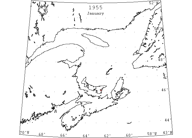
Jan 10 “Maria Labrringe” sailed for Florida taking 66,000 bags of potatoes. Possibly last boat of season. (Pat 10 Jan p4 c2)
Jan 21 Shipping finished at Georgetown. (Pat 21 Jan p6 c5)
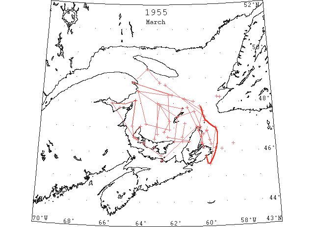
Mar In the Gulf of St. Lawrence area, the steamer track from Cabot Strait to Gaspe Passage was clear throughout the last 3 weeks of March, except for occasional strings and patches of scattered floes and loose slob ice. To the southwest of this track and in the St. Lawrence River heavy concentrations of field ice persisted to the end of the month. (IIP, P5).
Mar 9 Northumberland Strait to West Point, PEI to Bay Chaleur 90% cover, field ice (IIP p8#20)
Mar 9 North side Bay Chaleur to Gaspé Harbor, clear (IIP p8#21)
Mar 9 Gaspé Harbor to South-west Point, Anticosti Island to 48°50’N 62°50’W loose ice drift (IIP p9#22)
Mar 9 48°50’N 62°50’W to Magdalen Islands to St. Paul Island, clear (IIP p9#23)
Mar 9 Along west coast Cape Breton Island Loose ice drift (IIP p9#24)
Mar 10 Northumberland Strait 90% cover, field ice (IIP p9#25)
Mar 10 Inside line from 47°10’N 63°40’W to 46°55’N 62°15’W to 48°20’N 62°20’W to Bonaventure Island to 47°10’N 63°40’W Ice field, 70% cover (IIP p9#26)
Mar 15 46°08’N 59°11’W Ice field, 2 miles long (IIP p9#32)
Mar 15 Northumberland Strait 70% cover (IIP p9#34)
Mar 15 Along coast, West Point to North Point, PEI and to limit 35 mile visibility, close pack (IIP p9#35)
Mar 15 South side Bay Chaleur, close field pack (IIP p9#36)
Mar 15 Gaspé passage to 48°20’N 62°05’W small fields loose drift ice. (IIP p9#37)
Mar 15 48°20’N 62°05’W to Bird Rocks to St. Paul Island, clear (IIP p9#38)
Mar 15 Along coast from Cape St. Lawrence to Pictou Harbor, close packed drift (IIP p9#39)
Mar 15 Between Cape Smokey, Cape Breton Island and Ciboux Island, loose drift ice. (IIP p9#40)
Mar 17 Along the shore of St. Paul Island, strips of field ice 2 miles wide. (IIP p9#49)
Mar 19 Northumberland Strait 90% ice cover. (IIP p9#54)
Mar 19 West Point to North Point, PEI to NB coast 100% cover (IIP p9#55)
Mar 19 Bonaventure Island to Magdalen Islands, numerous heavy pieces and new slob (IIP p9#56)
Mar 19 45°31’N 59°53’W to 47°00’N 59°30’W edge pack ice. (IIP p10#57)
Mar 19 46°20’N 58°30’W Ice field 5 miles by 20 miles. (IIP p10#58)
Mar 24 47°40’N 60°45’W Field ice (IIP p11#101)
Mar 24 From 48°13’N 59°10’W to 48°15’N 59°20’W field ice. (IIP p11#103)
Mar 24 15 miles off PEI to 48°00’N to Brion Island and Magdalens to East Point , PEI to west coast Cape Breton Island. Field ice limits (IIP p11#104)
Mar 24 From Magdalens to 47°40N 60°45’W to Money Point . Field ice limits (IIP p11#105)
Mar 24 5 to 15 miles off Money Point to Point Aconi. Close pack (IIP p11#106)
Mar 24 Sydney Harbor. Scattered drift ice. (IIP p11#107)
Mar 24 Sydney to Gabarus Bay Inlets Navigable drift (IIP p11#108)
Mar 24 George Bay to East Point PEI, Loose drift (IIP p11#109)
Mar 24 From 48°45’N 62°30’W to 10 miles north of St. Paul Island. Clear (IIP p11#110)
Mar 25 St. Paul Island, south shore, loose slob ice (IIP p11#116)
Mar 26 Eastern point large ice field lies at 47°52’N 60°25’W (IIP p11#119)
Mar 26 Northumberland Strait Close pack ice (IIP p11#120)
Mar 26 From Cape North to Point Aconi and 20 miles seaward close pack ice (IIP p11#121)
Mar 26 Between 7 and 20 miles northeast of Flat Point . 25% close pack ice, 20 miles long (IIP p11#122)
Mar 26 From 20 miles northeast of Bird Rocks to Gaspé Passage. Widely scattered heavy field ice. (IIP p11#123)
Mar 27 U.S.N.S. “Sgt. Jonah E. Kelley”: 46°09’N 59°33’W strip field ice 600 yards long. (IIP p11#128)
Mar 28 5 miles north of North Cape to 47°40’N 60°10’W to 48°10’N 61°20’W North and east limits of field ice in Cabot Strait. (IIP p11#129)
Mar 28 20 miles off west coast Cape Breton to 47°10N 61°20’W 60% field ice (IIP p11#130)
Mar 28 20 miles north of North Point PEI to 47°55’N 62°30’W to Dead Man Island to 46°50’N 62°35’W Cape Breton. Outside limits of ice fields, 60% cover (IIP p11#131)
Mar 28 From West Point, PEI, to a point 20 miles off North Point, PEI., continuous field heavy loose drift ice 3 to 10 miles wide. (IIP p11#132)
Mar 28 Egmont Bay Full close pack ice. (IIP p11#133)
Mar 28 Summerside harbor and entrance Closed. (IIP p11#134)
Mar 28 Island side of Cabot Strait. Continuous drift ice 2 to 8 miles wide. (IIP p12#135)
Mar 29 46°30’N 59°46’W String close ice 5 miles wide (IIP p12#139)
Mar 29 Westward between Cape Smokey and St.Paul Island, large body field ice. (IIP p12#140)
Apr The pack in the southwest half of the Gulf of St. Lawrence and in the St. Lawrence River rapidly broke up during the first 2 weeks of the month. By 16 April all routes to ports in the gulf and in the St. Lawrence River were essentially free of ice, except the Strait of Belle Isle route. (IIP, P6).
Apr 1 On west and east coasts of Cape Breton Island from East Point to St. Paul Island to 47°10’N 59°30’W to 46°20’N to 59°10’W to 45°50’N 59°30 to Cape Breton . Heavy field ice. (IIP p13#239)
Apr 2 Eastward from Cape North to 46°45’N 59°30’W to Flint Island to Scatari Light to 45°45’N 59°25’W to 45°45’N 59°40’W to 10 miles off Louisburg Light. Heavy drift ice (IIP p13#240)
Apr 3 45°40’N 59°50’W Heavy string field ice, 10 miles long, 1 mile wide (IIP p13#241)
Apr 4 Along east coast Cape Breton Island from Michaud Point to Scatari Island and 6 miles seaward. Continuous strings field ice. (IIP p14#267)
Apr 4 Along east coast Cape Breton Island from Scatari Island to Flat Point and 1 to 5 miles seaward, loose drift ice. (IIP p14#268)
Apr 4 Along east coast Cape Breton Island from Flat Point 12 miles northeastward. Loose ice drift. (IIP p14#269)
Apr 4 Along east coast Cape Breton Island from Ciboux Island to Cape North, narrow strip close pack ice. (IIP p14#270)
Apr 4 Along west coast Cape Breton Island from 6 miles off Cape North to 46°17’N 61°58’W to Cape George, continuous loose ice drift. (IIP p14#271&272)
Apr 4 Mainland side of Northumberland Strait from Ahmet Shoals to Cape George, loose ice drift. (IIP p14#273)
Apr 5 From Cape North to 47°03’N 59°54’W Heavy ice drift. (IIP p15#313)
Apr 5 Continuous field loose drift ice along E coast Cape Breton Island from Fourchu Light to Scatari Island. (IIP p15#314)
Apr 5 Along Cape Breton Island from Cape Morien to Ciboux Island to Cape North, narrow strip close pack ice. (IIP p15#315)
Apr 5 Loose drift ice along west coast Cape Breton Island from Cape North to 46°12’N 61°58’W to George Bay. (IIP p15#316)
Apr 5 Along Nova Scotia coast from Cape George to Wallace Harbor. Line of loose drift. (IIP p15#317)
Apr 5 Western end of Northumberland Strait. Loose drift ice. (IIP p15#318)
Apr 5 Chaleur Bay to Northumberland Strait. Continuous field loose drift ice. (IIP p15#319)
Apr 6 Along east coast Cape Breton Island from Fourchu Light to Scatari Island, continuous slob ice. (IIP p15#342)
Apr 6 Along east coast Cape Breton Island from Flint Island to Flat Point. Close pack ice. (IIP p15#343)
Apr 6 Along east coast Cape Breton Island from Point Aconi to Cape North. Continuous drift ice. (IIP P16#344)
Apr 6 Along west coast Cape Breton Island from Cape North to Cape George. Continuous field loose drift ice (IIP P16#345)
Apr 6 Southern side of Northumberland Strait from Cape George to Pugwash. Continuous loose drift ice. (IIP P16#346)
Apr 8 Along coast Cape Breton Island from 5 miles off Scatari Island to 46°25’N 59°25’W to 47°10’N 59°40’W to 47°15’N 60°55’W to 46°25’N 61°40’W to George Bay. Scattered fields heavy drift ice. (IIP P16 #357)
Apr 8 Northumberland Strait. Light to heavy concentrations of drift ice. (IIP P16 #358)
Apr 8 From 10 miles east of Tracadie to 5 miles off Cape d’Espair. Continuous field drift ice. (IIP P16 #359)
Apr 8 First arrival of season at Quebec. (WBB)
Apr 11 Northumberland Straits from Point Prim to Woods Island to East Point, isolated pieces field ice. (IIP P17 #397)
Apr 11 Indian Rocks. Large piece field ice aground. (IIP P17 #398)
Apr 11 5 miles northeast of Cape George towards Pictou Island. Large field piece 1 to 5 miles wide, 15 miles long. (IIP P17 #399)
Apr 11 West Northumberland Straits and Chaleur Bay. Several isolated fields. (IIP P17 # 400)
Apr 11 West coast Cape Breton Island. Field ice. (IIP P17#401)
Apr 12 Along shoreline east coast Cape Breton Island. Slob ice (IIP P17 #410)
Apr 12 Along west coast Cape Breton Island from 15 miles below Cape St. Lawrence to Inverness and 5 to 10 miles seaward. Loose ice drift. (IIP P17 #411)
Apr 12 Northumberland Strait. Scattered fields loose ice drift ice. (IIP P17 #412)
Apr 13 West coast Cape Breton Island from Pleasant Bay to Sea Wolf Island. 60% to 70% cover field ice. Narrow band close pack ice. (IIP P17 #425)
Apr 13 Northumberland Strait. Scattered patches loose drift ice. (IIP P17 #426)
Apr 13 Season for navigation opened Wednesday, April 13th. Record for this early in season. (Pat 28 Apr p3 c3)
Apr 14 From 46°57’N 60°10’W to 47°09’N 60°10’W Field ice. (IIP P18 #439)
Apr 14 46°11’N 59°42’W Small floe. (IIP P18 #441)
May 18 First Westbound steamer through the strait of Belle Isle. (WBB)
May 27 50°56’N 57°08’W. Small berg. (IIP, P34 #1038).
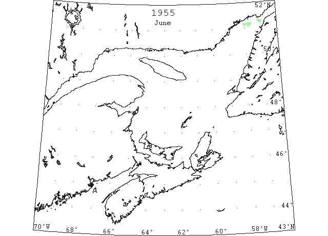
Jun 19 51°08’N 57°48’W. Berg. (IIP, P46 #1340).
Jun 19 51°08’N 58°00’W. Berg. (IIP, P46 #1341).
Jun 19 51°10’N 57°40’W. Berg. (IIP, P46 #1342).
Jun 19 51°14’N 57°02’W. Berg. (IIP, P46 #1343).
Jun 19 51°15’N 57°08’W. Berg. (IIP, P46 #1344).