1952 Season
Dec 9 Last eastbound steamer through the Strait of Belle Isle. (WBB)
Dec 16 Last departure of the season from Quebec. (WBB)
Dec 30 Georgetown News – SS “Ulna” in port over Sunday. Four steamers moored at Railway Wharf over weekend. SS “Brant” was standing by to assist those vessels in case of ice. (Pat 3 Jan 1952 p3 c7)
Jan 18 Ferries are still running at Newport and Georgetown. (Pat 18 Jan p4 c2)
Jan 23 Ice on the rivers cannot be safe for travel and a shortage of storage ice is reported, unless severe frost comes soon. It is getting late now. (Pat 23 Jan p4 c2)
Jan 23 SS “Montague” laid up after a long season’s work. (Pat 23 Jan p4 c8)
Feb On February 28, an International Ice Patrol plane en route from Halifax, Nova Scotia, to Argentia scouted the Cabot Strait area and reported the results directly to the Canadian Department of Transport. On a course from Scatari Island to St. Paul Island, and thence to Argentia, no ice was sighted except close inshore at St. Ann Bay. (IIP p9)
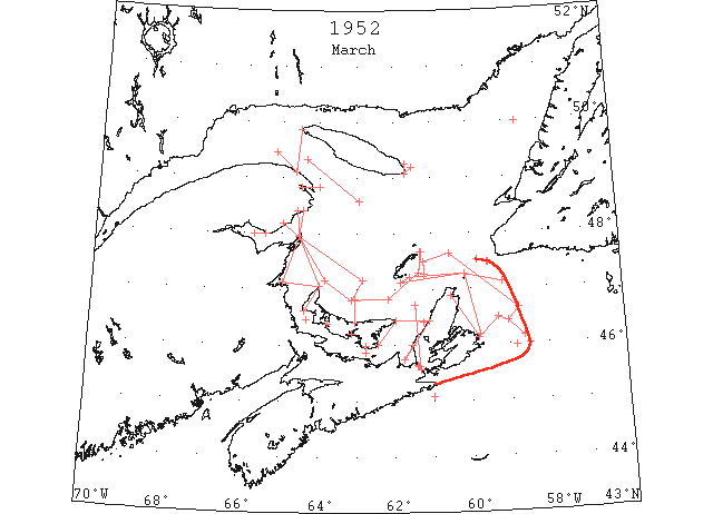
Mar On March 10, the Canadian Department of Transport began intermittent aerial surveys of the Gulf of St. Lawrence region and reported that ice conditions were much better than average and compared favorably with 1951, which had been an exceptionally light ice year. In general, drift ice was being discharged from the St. Lawrence river between Anticosti Island and the Gaspé Peninsula. The Strait of Canso, Northumberland Strait, and the west coast of Cape Breton Island were filled with close pack. A narrow strip of close pack also extended along the northeast coast of Cape Breton Island.
By the end of the month open strings of drift ice extending from Cape Breton to a northwest-southwest line running approximately from Bird Rocks to St. Paul Island to 47°10’N, 59°00’W had partially blocked Cabot Strait. North if this line, however, only occasional strings of drift ice caused any interference to navigators entering the strait. Conditions in Northumberland Strait and the Strait of Canso remained much the same during the month. Drift ice on the east coast of Cape Breton Island came as far south as Scatari Island. (IIP p6)
Mar 4 45°05’N 61°00’W. Drift ice. (IIP p14#67)
Mar 10 Northeast coast of Cape Breton Island. Close pack from Cape North to Cape Morien. (IIP p14#89)
Mar 10 Strait of Canso, Northumberland Strait and Chaleur Bay to Cape Gaspe. Close pack limit with strings of drift ice between Fame Point and Anticosti Island and to northwest in River St. Lawrence. (IIP p15#90)
Mar 10 DOT aerial survey: Bay of Chaleur full of heavy ice. (CIS IC0931)
Mar 10 DOT aerial survey: Northumberland Strait from East Point, Cape Bear to West and North Points mostly close packed with small lakes of open water; all harbours frozen on S and E coast of PEI and on Nova Scotia and New Brunswick coast. (CIS IC0938)
Mar 10 DOT aerial survey: S entrance to Strait of Canso to Balache Point large pan and heavy pieces of drift ice. Strait blocked with heavy sheets from Balache Point to N entrance. (CIS IC0960)
Mar 10 DOT aerial survey: George Bay solid with ice extending up NW coast of Cape Breton. (CIS IC0972)
Mar 10 DOT aerial survey: South coast of Newfoundland clear to limit of visibility from Cape Ray. (CIS IC1046)
Mar 10 DOT aerial survey: Northwestward in River St. Lawrence from Fame Point to end of visibility 30 miles, strings of loose drift, 50% ice. (CIS0709)
Mar 10 DOT aerial survey: Large lakes of open water 10 miles off Bonaventure Island to Gaspe. Off shore (from Gaspe Harbour) to end of visibility 20 miles patches and streams of loose drift. (CIS IC0750)
Mar 10 DOT aerial survey: Gaspe Harbour solid from light inward. (CIS IC0765)
Mar 10 DOT aerial survey: Over steamer track from 49°20’N 64°20’W to 48°35’N 62°55’W, strings and patches loose drift, 40% ice. From last position to N of Bird Rocks to St. Pauls Is. and Cape Ray, clear water. (CIS IC0793)
Mar 10 DOT aerial survey: Heavy ice from North point, PEI to Miscou Island. (CIS IC0796)
Mar 10 DOT aerial survey: Magdalens clear. (CIS IC0821)
Mar 10 DOT aerial survey: W coast of Newfoundland clear to limit of visibility from Cape Ray, with Corner Brook open. (CIS IC0838)
Mar 13 47°29’N 59°33’W. String ice. (IIP p15#92)
Mar 19 Gulf of St. Lawrence. Close pack ice in Northumberland Strait and Strait of Canso. North and East edge of Gulf ice in a line from 10 miles southeast Amherst Island to St. Paul Island to Flint Island. Small isolated patch of ice 20 miles northeast St. Paul Island. (IIP p15#108)
Mar 19 DOT aerial survey: Bay of Chaleur clear E of line from Miscou to Port Daniel, W of this line to Bonaventure Point mostly close packed, then a large lake of open water 30% slob to Heron Island, thence westward to Dalhousie and Campbellton solid board ice. (CIS IC0931)
Mar 19 DOT aerial survey: Northumberland Strait close packed East Point around South to North Point except for several strips of open water along the Island shore. Charlottetown and Summerside frozen. (CIS IC0938)
Mar 19 DOT aerial survey: S entrance to Strait of Canso and Chedabucto Bay 75% heavy pans and large pieces. Strait blocked from Ship Point to N entrance with heavy sheet. (CIS IC0960)
Mar 19 DOT aerial survey: George Bay solid extending up the W coast of Cape Breton and across to East Point. (CIS IC0972 & IC0989)
Mar 19 DOT aerial survey: South coast of Newfoundland clear except for one small isolated patch 20 miles NE of St. Paul. (CIS IC1046)
Mar 19 DOT aerial survey: Little ice reported from Fame Point to Pointe des Monts. (CIS IC0709)
Mar 19 DOT aerial survey: Over steamer track clear water and S of track to end of visibility 20 miles and northward from N end of Magdalens to end of visibility 20 miles. (CIS IC0793)
Mar 19 DOT aerial survey: Close packed ice North point to New Brunswick shore extending to Miramachi Bay then open ice to Miscou Island. (CIS IC0796)
Mar 19 DOT aerial survey: N and E edge of Gulf ice from about 10 miles SE of Amherst Island to 5 miles off Entry Island to St. Paul Island. N of this line clear water to W coast of Newfoundland. (CIS IC0821)
Mar 19 DOT aerial survey: Clear water to W coast of Newfoundland extending northward to Bay of Islands with Corner Brook open. (CIS IC0838)
Mar 21 Cabot Strait. Ice patch ½ mile wide by 3 miles long, 130°, 41 miles from St. Paul Island. (IIP p15#118)
Mar 21 Ice conditions are still heavy in Gulf of St. Lawrence. Heavy ice extending about 25 miles out to sea on North side. (Pat 21 Mar p2 c3)
Mar 22 45°58’N 58°50’W. Slush ice in water. (IIP p15#121)
Mar 22 Cabot Strait. Open field ice in a northwest-southeast line approximately 14 miles southwest of Cape Ray. (IIP p15#122)
Mar 25 DOT aerial survey: S entrance to Strait of Canso scattered pieces of heavy drift. Port Hawkesbury to N entrance 50% heavy drift. (CIS IC0960)
Mar 26 48°25’N 64°25’W to Miscou Island to 47°10’N 63°50’W to 46°48’N 63°08’W to 46°50’N 62°10’W to 47°18’N 61°21’W to 47°40’N 61°20’W. Northern and eastern limits of gulf ice with open and close pack south and west of this limit and in Strait of Canso. (IIP p16#133)
Mar 26 DOT aerial survey: Westward in the Bay[Chaleur] mostly close packed to the vicinity of Bonaventure Point. (CIS IC0931)
Mar 26 DOT aerial survey: In Northumberland Strait strips of open water along the S coast from Cape Bear to Victoria about 3 miles wide. Charlottetown Harbour open to near Rocky Point. (CIS IC0938)
Mar 26 DOT aerial survey: George Bay heavy ice extending up the W coast of Cape Breton and across to East Point, PEI. (CIS IC0972 &0989 )
Mar 26 DOT aerial survey: Clear water E of entrance to Bay of Chaleur. (CIS IC0750)
Mar 26 DOT aerial survey: Flight shows conditions over steamer track Fame Point to N of Bird Rocks excellent, no ice sighted. (CIS IC0793)
Mar 26 DOT aerial survey: N and eastern edge of ice in Gulf from 10 miles SE of Brion Island to 47°18’N 61°21’W to 46°50’N 62°10’W; to 46°48’N 63°08’W to 47°10’N 62°50’W; to Miscou Island to shore 10 miles W of Cap d’Espoir. S and W of these lines mostly open and close packed ice to the coast of Cape Breton and PEI. From North Point, PEI to Miscou Island the ice is loose about 70% ice. (CIS IC0812)
Mar 26 DOT aerial survey: N shore reported clear from Seven Islands to vicinity of Cape Whittle. Large fields reported today 10 miles N and NE of Heath Point. (CIS IC0854)
Mar 27 46°00’N 58°30’W. Extensive field ice. (IIP p16#135)
Mar 27 (From 20 miles E of Entry Island to) 47°30’N 61°15’W to 47°39’N 60°33’W to 46°39’N 58°45’W to 46°26’N 59°02’W to 46°30’N 59°18’W (to shore at Cape Morien) Outer limits of gulf ice with open and close pack ice inside this line to Cape Breton coast. Outside these positions clear to Newfoundland coast and northward to limit of visibility 50 miles. (IIP p16#137, CIS IC0838 & CIS IC1046)
Mar 27 Heavy drift from Cape Morien to 12 miles south Scatari Island. (IIP p16#138)
Mar 27 DOT aerial survey: From position 46°26’N 59°02’W there is a long narrow string of loose drift ice with heavy pieces extending SE for 25 miles. (CIS IC0906)
Mar 27 DOT aerial survey: No change in Strait of Canso. (CIS IC0960)
Mar 27 Souris River ice and all adjoining ice which has not been safe for travel, throughout entire winter, is now dangerous. (Pat 27 Mar 1952 p9 c5)
Mar 28 “Anguslake” 49°58’N 58°37’W drift ice. (IIP p16#150)
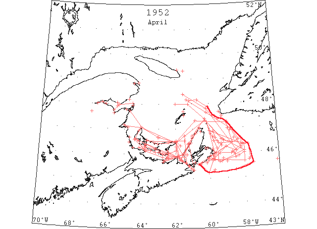
Apr On April 1 the Canadian Department of Transport began daily serial surveys, weather permitting, of the Cabot Strait and Gulf of St. Lawrence area. On the 17th, the St. Lawrence River was reported navigable to Quebec, and by the 14th, navigable to Montreal. By the 17th of the month the ice in the Cabot Strait had drifted to its maximum easterly extension, under the influence of the westerly winds. On this date open pack and drift ice extended from Cape Breton to a line from St. Paul Island to 46°20’N 57°40’W to 45°35’N 57°40’W to 45°20’N 58°30’W. Some scattered ice was also reported between St,. Paul Island and Cape Ray, but did not prevent passage through this area. By the end of the month most of the ice had disappeared, leaving only isolated patches off the east coast of Cape Breton. Routes via the Strait of Canso and Northumberland Strait were reported clearing, but not recommended yet for navigation. (IIP p8)
Apr 1 Gulf of St. Lawrence. Northern limits Gulf ice from Shippigan Island to North Point to East Point, Prince Edward Island to 47°20’N 60°15’W to St. Paul Island with open and close pack inside this line to shore. Close pack along east coast Cape Breton Island. Open and close pack in Strait of Canso. (IIP p17#158)
Apr 1 51°20’N 57°00’W. Berg. (IIP p17#158)
Apr 1 DOT aerial survey: Large expanse of open water runs due S from East Point, PEI for 20 miles thence 2 miles off Cape Bear to 2 miles off Pictou Island. Westward in Strait mostly heavy drift except Hillsboro Bay. (CIS IC0938_2)
Apr 1 DOT aerial survey: Scattered ice in Canso Harbour and Chedabucto Bay. Strait of Canso 50% heavy drift to Balache Point. N end solid. (CIS IC0960_2)
Apr 1 DOT aerial survey: George Bay solid extending up W coast of Cape Breton. Large expanse of open water runs due S from East Point, PEI for 20 miles thence 2 miles off Cape Bear to 2 miles off Pictou Island. (CIS IC0989 & 0972)
Apr 1 DOT aerial survey: South coast of Newfoundland clear to Cape Race. (CIS IC0946)
Apr 1 DOT aerial survey: Over steamer track Fame Point to Bird Rocks to Cape Ray clear. (CIS IC0793_2)
Apr 1 DOT aerial survey: Outer limits from St, Pauls to 47°20’N 60°50’W to 2 miles off East Point, PEI to 46°41’N 63°00’W; to North Point, PEI to Shippigan. Inside these limits mostly open close packed to Cape Breton and PEI shore. (CIS IC0812)
Apr 2 Gulf of St. Lawrence. Ice field near 49°20’N 61°30’W. Outer limits ice off east coast of Cape Breton Island from St. Paul Island to 46°35’N 59°19’W to 46°34’N 59°14’W to 46°05’N 58°00’W to 45°40’N 59°20’W to 45°45’N 59°43’W to east end Scatari Island, with open and close pack ice inside this line. (IIP p17#164)
Apr 2 DOT aerial survey: Outer edge of ice from 46°00’N 58°00’W to 45°52’N 58°20’W to 45°40’N 59°20’W to 45°45’N 59°43’W to E end of Scatari. At extreme outer limits heavy loose drifts in strings and fields and close packed on the inside. (CIS IC0906)
Apr 2 DOT aerial survey: N side of Bay of Chaleur loosening up, clear to Cap d’Espoir. Dalhousie solid to Heron Island. (CIS IC0931)
Apr 2 DOT aerial survey: Northumberland Strait little change from yesterday’s report but appears to be loosening up. (CIS IC0938_2)
Apr 2 DOT aerial survey: Loose drift from S entrance of Strait of Canso to Cranberry Island, Strait of Canso from S entrance to Balache Point 85% heavy drift. Blocked solid from Balache Point north, scattered ice Chedabucto Bay loose in Strait of Canso. (CIS IC0960_2)
Apr 2 DOT aerial survey: George Bay solid. (CIS IC0972)
Apr 2 DOT aerial survey: No known ice S of Cabot Strait. (CIS IC1008)
Apr 2 DOT aerial survey: W coast of Newfoundland clear to Corner Brook and S coast [of Newfoundland] clear to Cape Race. (CIS IC1046 & IC0838_2)
Apr 2 DOT aerial survey: Gaspe Harbour solid. (CIS IC0750)
Apr 3 DOT aerial survey: Report same as yesterday except outer edge Guion Island moving W. (CIS IC0906)
Apr 3 DOT aerial survey: Large fields reported N of Heath Point has now moved S of the Point. (CIS IC0854)
Apr 4 Gulf of St. Lawrence. Quebec to Cape des Rosiers: some scattered ice. (IIP p17#168)
Apr 4 DOT aerial survey: Bay of Chaleur clearing along N side to Bonaventure. Caraquet, Bathurst full. Dalhousie solid to Heron Island. (CIS IC0931_2)
Apr 4 DOT aerial survey: Northumberland Strait loosening up. Pictou Harbour solid. Summerside some opening in channel. Tormentine loose drift in Strait. (CIS IC0938_2)
Apr 4 DOT aerial survey: Cape Ray, W and S coast of Newfoundland clear. (CIS IC1046_2 & IC0838_2)
Apr 4 DOT aerial survey: Gaspe Bay solid. (CIS IC0765)
Apr 4 DOT aerial survey: Over steamer track Fame Point to Cape Ray clear. (CIS IC0793_2)
Apr 5 Louisburg Harbor: ice ½ mile offshore. 3/10 pack in Strait of Canso. Ice strip 8 miles long, 2 miles wide off Tablehead, Anticosti Island. (IIP p17#169)
Apr 6 DOT aerial survey: No change reported in Bay of Chaleur. Bathurst channel inside open, harbour and entrance blocked. Bonaventure appears free of ice. New Carlisle much ice. (CIS IC0931_2)
Apr 6 DOT aerial survey: Shediac Bay still full of ice. Cape Tormentine heavy drift ice. Pictou Harbour over. Summerside ice breaking up, large opening in channel, little movement. (CIS IC0938_2)
Apr 6 DOT aerial survey: In the Strait of Canso little ice reported at Mulgrave. Large area of open water in George Bay. (CIS IC0960_2)
Apr 6 DOT aerial survey: Large area of open water in George Bay extending up W coast of Cape Breton. (CIS IC0972_2)
Apr 6 DOT aerial survey: E wind holding ice in river. West Point no ice in sight. (CIS IC0750)
Apr 6 DOT aerial survey: Over steamer track Fame Point to Cape Ray clear. (CIS IC0793_2)
Apr 6 DOT aerial survey: Point Escumiac heavy close pack ice everywhere. (CIS IC0796)
Apr 6 DOT aerial survey: Magdalen Islands no ice in sight. (CIS IC0821)
Apr 6 DOT aerial survey: St. Paul Island, loose pack everywhere. (CIS IC0838_2)
Apr 6 DOT aerial survey: W coast of Newfoundland clear to Corner Brook. (CIS IC0848)
Apr 7 Gulf of St. Lawrence. Approaches to Sydney harbor, close packed. Louisburg harbor and approaches close packed. (IIP p17#171)
Apr 7 St. Paul Island to 47°14’N 59°00’W to 46°25’N 58°40’W to 46°24’N 59°20’W to 3 miles off Scatari Island to 6 miles off Louisburg to Point Michaud. Outer limits of Gulf ice. (IIP p17#172)
Apr 7 46°55’N 58°47’W. Loose slush ice. (IIP p17#174)
Apr 7 DOT aerial survey: Bay of Chaleur clearing along N shore. Maquereau and Bonaventure clear, Carlisle considerable ice. Dalhousie solid to Heron Island. Caraquet Harbour full of ice. Bathurst channel open, inside and mouth of harbour blocked. (CIS IC0931_2)
Apr 7 DOT aerial survey: Northumberland Strait close packed on PEI side from Point Prim to Cape Bear. Nova Scotia to Caribou to 3 miles W of Cape George 15% heavy loose drift. Pictou strip of ice in harbour. Cape Tormentine heavy ice everywhere. Summerside open water in channel, some ice movement. Shediac Bay still full of ice. (CIS IC0938_3)
Apr 7 DOT aerial survey: Strait of Canso clear. (CIS IC0960_2)
Apr 7 DOT aerial survey: George Bay 50% loose drift ice. N entrance to George Bay blocked. Heavy ice in a line from Cape George due E to the Cape Breton shore. (CIS IC0972_2)
Apr 7 DOT aerial survey: Heath Point no ice in sight. (CIS IC0750)
Apr 7 DOT aerial survey: Over steamer track Fame Point to Cape Ray clear. (CIS IC0793_2)
Apr 7 DOT aerial survey: Open water along the coast of PEI from East Point to Tracadie Bay to end of visibility. (CIS IC0821)
Apr 8 47°23’N 59°30’W. Northern edge of ice pack. (IIP p17#175)
Apr 8 First arrival of season at Quebec. (WBB)
Apr 9 47°00’N 58°56’W. Small ice floe. (IIP p18#180)
Apr 9 46°36’N 58°34’W. Small ice floe. (IIP p18#181)
Apr 9 DOT aerial survey: Outer limits from Point Michaud to 6 miles off Louisburg to 46°32’N 58°20’W; 47°15’N 58°56’W to 14 miles S of Cape Ray. (CIS IC0907)
Apr 9 DOT aerial survey: Bay of Chaleur little change, Maquereau, Dalhousie, Shippigan and Miscou solid. Bathurst and Caraquet entrance blocked. (CIS IC0931_2)
Apr 9 DOT aerial survey: Port Hood full of ice. (CIS IC0972_2)
Apr 9 DOT aerial survey: N entrance to George Bay blocked between Cape George and Henry Island extending from Henry Island to East Point where it becomes loose drift. Large bay of open water extending 15 miles from East point eastward, 20% drift. (CIS IC0989)
Apr 9 DOT aerial survey: No known ice S of Cabot Strait. (CIS IC1008)
Apr 9 DOT aerial survey: Sydney harbour and approaches full. Sydney clear of ice. [?] (CIS 1027_2)
Apr 9 DOT aerial survey: Over steamer track clear from Fame Point eastward 20 miles northwestward of Bird Rocks and several patches of loose ice on both sides 15 miles S of Cape Ray. (CIS IC0793_2)
Apr 9 DOT aerial survey: Ships bound up river pass from 10 miles off Cape Ray to 20 miles NE off Bird Rocks to 10 miles off Fame Point. (CIS IC0793_3)
Apr 9 DOT aerial survey: Strip of loose ice around the N end of the Magdalens from 48°00’N 62°00’W to 48°00’N 61°15’W to 47°24’N 60°15’W to 5 miles N Cheticamp. Pleasant Bay half full of broken ice. Grosse Isle broken ice distant. Old Harry no ice. Etang du Nord no ice. Amherst no ice. Entry Island no ice. (CIS IC0812_2 & 0821)
Apr 10 Cabot Strait. Large field of ice bearing 205° from Cape Ray distance 10 miles. (IIP p18#191)
Apr 10 Point Michaud to 15 miles off Guion Island to 6 miles off Louisburg to 46°16’N 59°03’W to 46°05’N 58°27’W to 46°11’N 58°10’W to 47°00’N 48°45’W to 48°10’N 61°20’W. Outer limits of gulf ice. (IIP p18#196)
Apr 11 Point Michaud to 15 miles off Guion Island to 46°16’N 59°03’W to 46°05’N 58°27’W to 47°49’N 60°10’W to 48°24’N 61°32’W. Outer limits of gulf ice. (IIP p18#197)
Apr 11 47°30’N 59°15’W to 47°40’N 59°25’W. Eastern limit of ice. (IIP p18#201)
Apr 11 DOT aerial survey: Point Maquereau no ice. Bathurst channel open and breaking up, but harbour full of ice. (CIS IC0931_3)
Apr 11 DOT aerial survey: Cape Tormentine heavy drifting ice with open water. Richibucto ice breaking up, not moving yet. Pictou Harbour clear, no change elsewhere. Ice from 2 miles off Cape George to 5 NE of Pictou Island to Point Prim entrance, Pictou Harbour heavy loose drift 60%. Hillsboro Bay open. Heavy ice on Nova Scotia side from Pictou Island west. (CIS IC0938_3)
Apr 11 DOT aerial survey: S entrance Strait of Canso to Eddy Point clear, heavy pans flowing S from N entrance. (CIS IC0960_3)
Apr 11 DOT aerial survey: George Bay 60% heavy pans and drifts, George Bay to East Point 80% heavy ice. (CIS IC0972_2)
Apr 11 DOT aerial survey: George Bay to East Point about 80% heavy drift ice. George Bay 85% heavy ice extending up the W coast of Cape Breton from 5 miles off Cape George 10 to 15 miles off Henry Island. E coast of PEI clear from East Point to Cape Bear. (CIS IC0989_2)
Apr 11 DOT aerial survey: Sydney harbour entrance loose ice in all directions. (CIS IC1027_2)
Apr 11 DOT aerial survey: Over steamer [track] to Fame point eastward to the meridian 61°32’W, clear then patches of broken ice along the S side to Cape Ray moving northward, clear to the N. Cap des Rosiers no ice in sight. (CIS IC0793_3)
Apr 11 DOT aerial survey: Ice on N side of PEI about 15 miles off the coast. (CIS IC0821_2)
Apr 12 45°16’N 59°48’W. Field ice. (IIP p18#203)
Apr 12 48°08’N 61°10’W to 48°10’N 60°42’W to 47°52’N 60°03’W. Northern limits of gulf ice. (IIP p18#204)
Apr 12 Cabot Strait. Ice about 10 miles off east coast Cape Breton, extending to 40 miles south of Scatari Island. (IIP p19#205)
Apr 13 St. Paul Island to 46°55’N 60°00’W to 46°21’N 58°04’W to 46°00’N 58°45’W to 46°00’N 59°30’W to 45°44’N 59°30’W to 45°42’N 59°50’W to Scatari Island to Cape Percy. Outer limits of gulf ice. (IIP p19#209)
Apr 13 Cabot Strait. Loose drift 20 miles north of St. Paul Island. (IIP p19#210)
Apr 13 45°39’N 59°25’W. Strings and patches dangerous to navigation. (IIP p19#211)
Apr 13 45°42’N 57°44’W. Loose string of field ice. (IIP p19#212)
Apr 13 DOT aerial survey: No ice sighted to the end of visibility southward 45°35’N 59°42’W. (CIS IC0907)
Apr 13 DOT aerial survey: Bay of Chaleur clearing along N side. Bonaventure scattered ice, Bathurst breaking up. Dalhousie ice barrier across outer harbour, still solid. Point Maquereau no ice. Bonaventure less ice on sea. (CIS IC0931_3)
Apr 13 DOT aerial survey: Summerside Harbour clear, some patches of ice remaining. Shediac Bay still full of ice. (CIS IC0938_4)
Apr 13 47°30’N 59°40’W. Loose drift ice. (IIP p19#233)
Apr 13 DOT aerial survey: S entrance to Strait of Canso loose drift, heavy pieces extending to Cranberry Island from Eddy point to Balache Point 70% heavy drift. Blocked solid at N entrance. (CIS IC0960_3)
Apr 13 DOT aerial survey: George Bay full of ice except for large lake on the W side. (CIS IC0972_2)
Apr 13 DOT aerial survey: Over steamer track cleared to N of Bird Rocks to 20 miles off Cape Ray. (CIS IC0793_3)
Apr 13 DOT aerial survey: Escumiac Point heavy close packed ice in shore. (CIS IC0796)
Apr 14 45°47’N 59°13’W. Edge of field ice. (IIP p19#213)
Apr 14 “Gardenia” edge of field ice 45°38’N 56°06’W. (IIP p19#231)
Apr 14 DOT aerial survey: Bay of Chaleur clearing; along N shore loose ice at Bonaventure. (CIS IC0931_3)
Apr 14 DOT aerial survey: S entrance to Strait of Canso ice extends to the vicinity of Cranberry Island. From Eddy Point to Balache Point 70% heavy drift close packed at N entrance. (CIS IC0960_3)
Apr 14 DOT aerial survey: Sydney harbour clear. (CIS IC1027_2)
Apr 14 DOT aerial survey: Gaspe Bay solid. (CIS IC0765)
Apr 14 DOT aerial survey: Over steamer track Fame point to Bird Rocks 20 miles W of Cape Ray no ice sighted. Larger area loose drift ice 20 miles NE of St. Paul Island extending northeastward. (CIS IC0793_3)
Apr 15 45°50’N 58°30’W. Approximate southeast limit of field ice. (IIP p19#238)
Apr 15 St. Paul Island to 46°55’N 60°00’W to 46°21’N 58°05’W to 46°20’N 58°00’W to 45°40’N 58°00’W to vicinity Guion Island. Outer edge loose drift ice. (IIP p20#244)
Apr 15 DOT aerial survey: Bathurst ice breaking up and a lot of drift ice. (CIS IC0931_3)
Apr 15 DOT aerial survey: Summerside Harbour mostly clear, some patches moving. Pictou, ice the same. Shediac Bay full of ice. Cape Tormentine heavy drift ice. 60% heavy loose drift from Cape George to Pictou Island. Pictou Island west mostly heavy close packed except for strip of open water along PEI shore 1 to 10 miles wide. Summerside Harbour mostly clear. Pictou Harbour clear ice conditions good outside. (CIS IC0938_4)
Apr 15 DOT aerial survey: Port Hood Bay blocked with ice, open water S. (CIS IC0972_3)
Apr 15 DOT aerial survey: Sydney no ice in sight. (CIS IC1027_2)
Apr 16 St. Paul Island to 46°30’N 59°10’W to 46°20’N 57°45’W to 45°46’N 57°40’W. Outer limits of Cabot Strait ice. (IIP p20#248)
Apr 16 DOT aerial survey: Outer limits from St. Paul Island to 46°30’N 59°10’W to 46°20’N 57°45’W to 45°46’N 57°40’W [as above]. Several large patches at last position. No ice sighted E of SE to limit of visibility 30 miles. Several large patches at 45°40’N 59°00’W; large field mostly close packed from Louisburg to 45°42’N 59°50’W to 45°13’N 60°06’W; thence direct to 5 miles off Pointe Michaud to shore at St. Esprit. (CIS IC0907)
Apr 16 DOT aerial survey: Bay of Chaleur clearing along N shore, Bathurst considerable drift ice. Bonaventure ice distant, Carquet Harbour full of ice. (CIS IC0931_4)
Apr 16 DOT aerial survey: Shediac Bay full of ice. (CIS IC0938_4)
Apr 16 DOT aerial survey: Northward from Eddy Point to Balache Point 85% heavy drift. N entrance blocked. Scattered heavy pieces extend 10 miles S from entrance to Strait of Canso. George Bay and Strait of Canso very little change. Loose drift in S entrance across Chedabucto Bay to Cranberry Island. (CIS IC0960_3-IC0960_4))
Apr 16 DOT aerial survey: George Bay 85% heavy ice, extending up the W coast of Cape Breton from 5 miles off Cape George 10 to 15 miles off Henry Island. Port Hood Bay full of ice. (CIS IC0972_3)
Apr 16 DOT aerial survey: Sydney harbour and approaches clear. (CIS IC1027_2)
Apr 16 DOT aerial survey: Gaspe Bay solid. (CIS IC0765)
Apr 16 DOT aerial survey: Over steamer track Fame Point to Bird Rocks to Cape Ray clear. (CIS IC0793_4)
Apr 17 DOT aerial survey: Outer limits from St. Paul Island to 46°30’N 59°10’W to 46°20’N 57°45’W to 45°35’N 57°30’W to 45°20’N 58°30’W. Several large patches at last three positions. Several large patches vicinity of 45°40’N 59°00’W. Large field from Louisburg to 45°42’N 59°50’W to 45°13’N 60°06’W to 5 miles off Point Michaud to St. Esprit. (CIS IC0908)
Apr 17 DOT aerial survey: Bay of Chaleur ice S of a line from N end of Miscou to 2 miles off Carlisle then SW to S shore. Strip of loose drift 5 miles wide from Point Maquereau to main body. Dalhousie very little change in ice conditions, river still solid. Ice still in outside harbour. Caraquet full of ice. Bonaventure sea free of ice. (CIS IC0931_4)
Apr 17 DOT aerial survey: Northumberland Strait from Cape Bear to Point Prim 60% loose drift. Strip of open water on PEI side from St. Peter Island to Borden westward into strait mostly loose drift extending from North Point to Miramichi Bay. Pictou Harbour clear, ice conditions good outside. Summerside, very little ice in sight this morning. Cape Tormentine still heavy drift ice. (CIS IC0938_4-IC0938_5)
Apr 17 DOT aerial survey: Port Hood Bay blocked with ice. (CIS IC0972_3)
Apr 17 DOT aerial survey: Sydney harbour clear, narrow strip about 2 miles wide 5 miles offshore. (CIS IC1027_3)
Apr 17 DOT aerial survey: South coast of Newfoundland clear. (CIS IC1046_2)
Apr 17 DOT aerial survey: Over steamer tack clear to Fame point to 10 miles N off Bird Rock to Cape Ray. (CIS IC0793_4)
Apr 17 DOT aerial survey: Miramachi Bay closed W off Portage Island, entrance open. (CIS IC0796)
Apr 18 DOT aerial survey: Dalhousie to Campbellton still solid. (CIS IC0931_4)
Apr 18 DOT aerial survey: Richibucto, ice moving out of channel, starting to break inshore. Summerside scattered in harbour clearing slowly. (CIS IC0938_5)
Apr 19 Cabot Strait. Scattered ice along the east coast of Cape Breton from St. Paul Island to Scatari Island. (IIP p20#275)
Apr 19 DOT aerial survey: Bay of Chaleur, ice S of a line from Miscou to 2 miles off Carlisle, then SW to S shore. Dalhousie and Campbellton solid. (CIS IC0931_4)
Apr 19 DOT aerial survey: Northumberland Strait from Cape Bear to Point Prim 85% with open along Nova Scotia side. Pictou Harbour clear. Westward in Strait ice loosening up, loose drift to North Point and Miramachi Bay. Summerside, large area of drift ice in harbour this morning. Shediac little ice left. Cape Tormentine, only ice visible here is distant offshore. (CIS IC0938_5-IC0938_6)
Apr 19 DOT aerial survey: Scattered ice with about 20% heavy pieces off S entrance to Canso and through the Strait to N entrance where there is a lake of open water. (CIS IC0960_4)
Apr 19 DOT aerial survey: George Bay 85% except for a lake of open water on the W side. (CIS IC0972_3)
Apr 19 DOT aerial survey: Loose drift ice 70% from Cape George to 10 miles S of East Point. (CIS IC0989_2)
Apr 19 DOT aerial survey: Sydney harbour clear. (CIS IC1027_3)
Apr 19 DOT aerial survey: South coast of Newfoundland clear. (CIS IC1046_2)
Apr 19 DOT aerial survey: Gaspe being broken. (CIS IC0765)
Apr 19 DOT aerial survey: Over steamer track Fame point to 10 miles N of Bird Rock to Cape Ray clear. (CIS IC0793_4)
Apr 20 DOT aerial survey: The ice along the S coast of Cape Breton is moving rapidly eastward and is expected to clear the coast at Louisburg Monday. (CIS IC0908)
Apr 20 DOT aerial survey: Pictou Harbour and approaches clear. (CIS IC0938_6)
Apr 20 DOT aerial survey: Strait of Canso little ice. (CIS IC0960_4)
Apr 20 DOT aerial survey: George Bay clear, ice moving westward along W coast of Cape Breton. (CIS IC0972_3)
Apr 21 Cabot Strait. Scattered strings and patches extend 30 miles offshore between Cape North and Ingonish and 10 to 15 miles offshore between Scatari and Esprit. (IIP p21#279)
Apr 21 DOT aerial survey: Bay of Chaleur navigable along N side to Campbellton being broken by ice-breaker. Bonaventure much ice. (CIS IC0931_5)
Apr 21 DOT aerial survey: Ice in Northumberland Strait concentrated mainly in center of strait to Tormentine. Strip of open water along Island side Cape Bear to Point Prim to Cape Traverse. West of Tormentine field about 2 miles wide from Cape Jouriman to 2 miles off West Point to 10 miles S and W off North Point to 3 miles of North Point. Richibucto Harbour open, Buctouche Harbour narrow channel open in entrance with a large sheet of old ice in side the bar. (CIS IC09038_6)
Apr 21 DOT aerial survey: Scattered ice in St. Peters Bay and S entrance Strait of Canso. Strait about 40% full heavy ice. (CIS IC0960_4)
Apr 21 DOT aerial survey: George Bay full extending up W coast of Cape Breton 2 to 6 miles wide. (CIS IC0972_4)
Apr 21 DOT aerial survey: Over steamer track Fame point to 10 miles off Bird Rock to Cape Ray clear. (CIS IC0793_4)
Apr 21 DOT aerial survey: Miramachi opening up. (CIS IC0796)
Apr 22 DOT aerial survey: George Bay full extending up W coast of Cape Breton 20 to 6 miles wide. E coast of PEI clear between Cape Bear and East Point. Ice along the W coast of Cape Breton to Cape North with a field 10 to 15 miles wide extending from East Point to Wolf Island. (CIS IC0989_2-IC0989_3)
Apr 22 46°30’N 59°45’W. Approximate center string of ice 8 to 10 miles wide, 20 miles long running north-northwest to south-southeast. (IIP p21#284 & 298)
Apr 22 46°25’N 59°28’W. Loose ice. (IIP p21#299)
Apr 22 DOT aerial survey: Bay of Chaleur navigable along N shore, icebreaker breaking Dalhousie Harbour. Ice in Restigouche Harbour moving out. Miscou, Shippigan, Bathurst Harbours breaking up, Caraquet full. (CIS IC0931_5)
Apr 22 DOT aerial survey: Only ice remaining is located in the Baie de Chaleur, and Northumberland Strait, from Richibucto eastward. Also from George Bay along W coast of Cape Breton to Cape North with a field 10 to 15 miles wide extending from East Point to Wolf Island. Cape George to Point Prim 60% loose ice. Entrance to Charlottetown Harbour navigable. Pictou entrance about 20% clear water along PEI side to Victoria. Westward off Tormentine little change from yesterday. All harbours in PEI and Northumberland open. Ice moving eastward with SW wind which is expected to clear George Bay. (CIS IC0938_7)
Apr 22 DOT aerial survey: Strait of Canso 10% drift extending southward into Chedabucto Bay; N entrance blocked solid at Cape Jack. (CIS IC0960_5)
Apr 22 DOT aerial survey: Ice in George Bay. George Bay W side 50%, E side 85% full/ (CIS IC0972_4)
Apr 22 DOT aerial survey: Steamer track from Fame point to Bird Rock to Cape Ray clear. (CIS IC0793_4)
Apr 22 DOT aerial survey: Miramachi Bay clear. (CIS IC0796)
Apr 22 DOT aerial survey: Magdalen Islands clear. (CIS IC0812_2)
Apr 22 DOT aerial survey: N coast of PEI W of Tracadie clear. E of Tracadie ice leaves shore at Shipwreck Point and extends to 5 miles N of East Point and thence as loose drift 20 miles eastward. (CIS IC0821_2)
Apr 23 Cabot Strait. Few scattered strings, 4 miles off Guion Island. (IIP p21#302)
Apr 23 DOT aerial survey: Dalhousie open. (CIS IC0931_5)
Apr 23 DOT aerial survey: Ice in George Bay has loosened up and moved over on the Cape Breton shore and has become soft but NW winds will pack it in again and route through the Strait of Canso not recommended at present. (CIS IC0972_4)
Apr 23 DOT aerial survey: Cape George to Cape Bear and East Point little ice reported. (CIS IC0989_3)
Apr 24 Gulf of St. Lawrence. Western edge of ice in Northumberland Strait, in a line from Cape Jouriman to Egmont Bay with all ice moving East. (IIP p21#304)
Apr 24 DOT aerial survey: Bay of Chaleur to Dalhousie considerable ice on S side of bay at Caraquet and passing Shippigan. Bathurst open. (CIS IC0931_5)
Apr 24 DOT aerial survey: Westward from Cape George strings and patches; navigable with caution along Nova Scotia side. Western edge of ice in Strait at noon a line from Cape Jouriman to Egmont Bay moving E, clear W of this line. It is expected the route through Northumberland Strait via West Point will be navigable to Summerside and Charlottetown on the 26th. (CIS IC0938_7-IC0938_8)
Apr 24 DOT aerial survey: Strait of Canso from Eddy Point to Balache Point 60% drift becoming soft. Thence to 5 miles NW of Cape Jack close packed. (CIS IC0960_5)
Apr 24 DOT aerial survey: George Bay open from 5 miles NW of Cape Jack to Cape George except for strip along Cape Breton side 5 miles wide. (CIS IC0972_4)
Apr 24 DOT aerial survey: Sydney harbour clear. (CIS IC1027_3)
Apr 25 DOT aerial survey: Scattered strings reported 5 miles E of Scatari. (CIS IC0908)
Apr 25 DOT aerial survey: Pictou Harbour clear. Westward from Pictou Island scattered strings along the Nova Scotia side, navigable with caution. Western edge of ice has moved eastward of yesterday’s position. Some patches visible off Summerside. Shediac Bay clear. Richibucto Harbour clear, navigation now open Richibucto and Miramichi. (CIS IC0938_8)
Apr 25 DOT aerial survey: Scattered ice off Green Island and S entrance Strait of Canso. Strait full of soft loosely packed ice extending into George Bay. (CIS IC0960_5)
Apr 25 DOT aerial survey: George Bay three-quarters full. Close packed on the Cape Breton side extending up the coast to Cape St. Lawrence. (CIS IC0972_5)
Apr 26 Gulf of St. Lawrence. Patch of soft ice in vicinity Cape North and Scatari Island. String 8 miles long at 46°00’N 58°36’W [extends NW – SE (CIS IC0908)]. Considerable loose ice in Northumberland Strait and Strait of Canso. (IIP p22#356)
Apr 26 DOT aerial survey: Bay of Chaleur navigable to Dalhousie, considerable ice on S side at Caraquet, Shippigan and Miscou. (CIS IC0931_5)
Apr 26 DOT aerial survey: Cape George to Pictou Island 30% loose drift ice extending across to Cape Bear and along shore to Wood Island. W of Pictou Island 40% loose pans in center of Strait. 85% ice from 3 miles off St. Peters Island to 3 off Victoria to 5 off Borden to 8 off Cape Egmont. Clear water S of this line. Summerside Harbour blocked, Egmont Bay full 90%. Shore ice from West Point to North Point. (CIS IC 0938_8-IC0938_9)
Apr 26 DOT aerial survey: Considerable ice in Strait of Canso. (CIS IC0960_5)
Apr 26 DOT aerial survey: George Bay three-quarters full. (CIS IC0972_5)
Apr 26 DOT aerial survey: A string of loose drift ice off N side of PEI from Malpeque to Rustico. (CIS IC0821_2)
Apr 27 46°30’N 59°33’W. String of loose drift ice approximately 1 mile wide extending northwest-southeast to limit of visibility. (IIP p22#362 & 363)
Apr 27 DOT aerial survey: Strait of Canso loose drift from 60% to 20% to S entrance. N entrance 10% at time of observing. (CIS IC0960_5)
Apr 27 DOT aerial survey: George Bay S and W sides clear, 70% drift ice cover rest of bay. Navigable at time of observing. (CIS IC0972_5)
Apr 27 DOT aerial survey: loose drift along shore 2 to 3 miles wide from Tracadie to East Point, PEI. (CIS IC0821_2)
Apr 28 46°20’N 58°11’W. Loose ice north to visual limits and 5 miles south. (IIP p22#365)
Apr 28 DOT aerial survey: A long string at 46°00’N 58°36’W. Loose ice vicinity of 46°20’N 58°11’W. (CIS IC0908)
Apr 28 DOT aerial survey: From Cape George westward in Strait ice extends in strings and patches and scattered pans to Egmont Bay being more closely packed along the island side, navigable along S side. Tormentine, ice distant, Summerside, ice at entrance to harbour Egmont Bay full. (CIS IC0938_9)
Apr 28 DOT aerial survey: Route via Strait of Canso not recommended at present. 5% ice in Strait of Canso. (CIS IC0960_6)
Apr 28 DOT aerial survey: 75% ice in George Bay some of this heavy, navigable with caution. (CIS IC0972_5)
Apr 28 DOT aerial survey: Strip of heavy ice extends along the W coast of Cape Breton with scattered pans extending eastward from East Point. (CIS IC0989_3)Apr 28 DOT aerial survey: Loose drift along N side of PEI 2 to 3 miles wide from Malpeque to East Point. Loose packed ice in Gulf about 3 miles offshore to limits of normal visibility extending to SE in Strait (Northumberland) from East Point. (CIS IC0821_2)
Apr 29 DOT aerial survey: Northumberland Strait 40% loose ice mostly concentrated in center of Strait from Cape Bear to Seacow Head. Clear on Nova Scotia side. Ice onshore at Cape Tormentine and Cape Jouriman. (CIS IC0938_9)
Apr 29 DOT aerial survey: Route via Strait of Canso clearing but not recommended. Strait of Canso about 5% ice, N entrance clear to 3 miles N. (CIS IC0960_6)
Apr 29 DOT aerial survey: George Bay about 30 to 40% ice in center of Bay from Cape George to Panmure Island, 25% loose ice. (CIS IC0972_5)
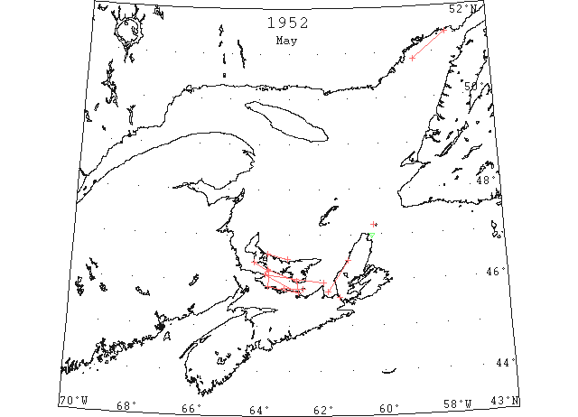
May Ice conditions in the St. Lawrence area improved rapidly early in the month. On May 2 the Strait of Canso and Northumberland Strait were reported navigable with caution, and on May 5 daily aerial surveys of the St. Lawrence were discontinued. On May 16, the last ice report of the year was issued by the Canadian Department of Transport and all the routes to the St. Lawrence were reported clear for navigation except via the Strait of Belle Isle. (IIP p10)
May 1 DOT aerial survey: Strong NW winds is drifting ice from Northumberland Strait into George Bay and Strait of Canso. Ice is 5 miles off Cape George and extends westward in strings and patches to vicinity of Cape Tormentine. This is moving E and is expected to clear PEI south coast today. Summerside Harbour and approaches no ice in sight. (CIS IC0938_10)
May 1 DOT aerial survey: George Bay filling up and route via Strait of Canso not recommended at present. This ice extends northward along the NW coast of Cape Breton and is heavy N and E of Inverness. (CIS IC0972_6 & 0960_6)
May 2 DOT aerial survey: Route via Strait of Canso and Northumberland Strait is now clearing with fresh SW winds and these routes are now navigable with caution. Summerside and Charlottetown Harbours clear. (CIS IC0938_10 & 0960_6)
May 2 DOT aerial survey: Port Hood, Margaree Island and East point, PEI report that route now practically clear. (CIS IC0972_6 & 0989_3)
May 3 Cabot Strait Ice strings 5 miles southwest St. Paul Island (IIP p24, # 436)
May 3 DOT aerial survey: In Northumberland Strait Cape Bear to Point Prim clear, S side clear to Caribou. Field of loose ice, rotten pans 5 miles extends across Strait from Cape Traverse to near Pugwash. Loose ice on island side 2 to 3 miles wide and some heavy pieces from Cape Traverse to Cape Egmont. (CIS IC0938_10-IC0938_11)
May 3 DOT aerial survey: Strait of Canso few scattered pieces. (CIS IC0960_6)
May 3 DOT aerial survey: George Bay few scattered strings. (CIS IC0972_6)
May 3 DOT aerial survey: Strip of loose drift 2 miles wide 1 to 5 miles offshore from Malpeque to Tracadie. (CIS IC0821_3)
May 4 Cabot Strait Very small growler, 10 miles 060°from Cape North (IIP p24, #438)
May 6 DOT aerial survey: Only ice liable to obstruct navigation is located in Northumberland Strait in an area between lines 10 miles W off Borden. Borden-Tormentine line and Wood Island-Caribou Island line. Within this area scattered small strings, patches and isolated pans, some heavy, dangerous to navigation, are moving about with the winds in current. (CIS IC0938_11)
May 8 DOT aerial survey: Only ice liable to obstruct navigation is located in Northumberland Strait in an area along Nova Scotia coast from Pugwash to vicinity of Caribou. Northerly winds have packed ice on this part of the coast being particularly heavy at Amet Sound and River John. (CIS IC0938_11)
May 9 DOT aerial survey: Field of heavy ice approximately 15 miles long, 3 miles wide extending from Amet Sound to Pictou Island. (CIS IC0938_11)
May 9 DOT aerial survey: Natashquan: according to reports May 7; no ice anywhere down to Blanc Sablon except Rigolet and St. Augustin, but clear out river. All harbours are also clear. (CIS IC0854)
May 16 Gulf of St. Lawrence Strip of ice along coast in Northumberland Strait. (IIP p25, #467)
May 23 21 miles offshore and extending from 51°25’N 57°30’W to 50°50’N 58°40’W Large field very open ice except for strings in heavy passage containing some very heavy pieces and pans. (IIP p26, #496)
Jun 19 First Westbound steamer through the strait of Belle Isle. (WBB)