1951 Season
Dec 15 Last eastbound steamer through the Strait of Belle Isle. (WBB)
Dec 25 Last departure of the season from Quebec. (WBB)

Jan 12 No ice on rivers to race on. (Pat 12 Jan p5 c2)
Jan 20 “Oddvar II” docked at Railway Wharf. Records reveal this date is not a record. Tanker expected on Saturday. (Pat 18 Jan p5 c4)
Jan 21 Yesterday Irving Oil tanker arrived in Montague. Believed to be a record. (Pat 22 Jan p8 c3)
Jan 23 Temperature dropped 50 degrees in 24 hour period. (Pat 23 Jan p1 c6)
Jan 23 “Oddvar” to leave port for Georgetown tonight. Not expected to have trouble leaving port for while ice has formed on both sides of harbour to considerable depth, still much open water in mid-harbour. Fairview continues daily run to Rocky Point. (Pat 23 Jan p5 c4)
Jan 24 Georgetown – Irving tanker arrived. No ice at this date in harbour or rivers. (Pat 24 Jan p8 c2)
Jan 25 Late sailing record established for “Oddvar”. Ship left Charlottetown January 25th but unable to make way to open water due to ice conditions. CGS “Laurel” broke a passage. (Pat 31 Jan p1 c4)
Feb 20 River Ice Tragedy – This winter has been unique in its mildness, strong but balmy gales. Harbour ice very rotten. (Pat 20 Feb p4 c1)
Feb 26 Large motor boat put into service at noon today between City and Rocky Point. (Pat 26 Feb p1 c5)
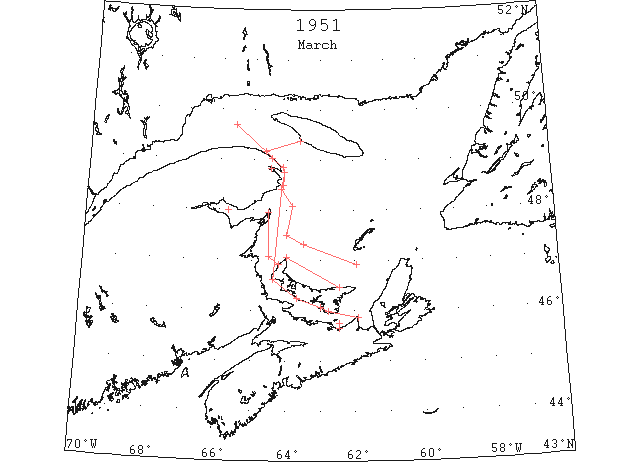
Mar The annual aerial survey of ice conditions in the Gulf of St. Lawrence and Cabot Straits was inaugurated by the Canadian Department of Transport on March 7 and reported “ice conditions abnormally good” with an assurance of a very early open navigation. (IIP p6)
Mar 1 Georgetown Ferry never missed a trip this winter. (Pat 1 Mar p4 c2)
Mar 7 Air Ice Patrol – Unusually mild weather has resulted in comparatively little ice in Gulf of St. Lawrence. No ice on east coast of Prince Edward Island. Route from Canso Strait to Charlottetown presently open. (Pat 7 Mar p4 c5)
Mar 8 DOT aerial survey: “I can’t remember similar conditions (to March 6, 1951) or the time when there was no ice on the W coast of Cape Breton, this is most unusual. Of course it will only be a short time now until this ice moves E and will block Strait of Canso and Cape Breton but the eastern areas are clear now and route to river should remain fairly clear.” (CIS IC0737)
Mar 19 DOT aerial survey: Bay of Chaleur full of close pack ice. (CIS IC0928)
Mar 19 DOT aerial survey: Ice starts again at Merigomish and extends from 2 to 10 miles off shore. (CIS IC0945)
Mar 19 DOT aerial survey: Clear from Heath Point across to East Point, PEI and to Souris Harbour and Strait of Canso. (CIS IC0737)
Mar 19 DOT aerial survey: From Bonaventure Island to Fame Point close pack 1 to 5 miles off shore. From Fame Point northwestward to end of visibility, 50 miles, large fields close pack and large lakes open water. Gaspe Harbour full of loose drift at entrance, close pack inner harbour. From 5 miles off Fame Point to Southwest, Anticosti, scattered strings of loose drift. Over steamer track from 5 miles off Fame Point navigable. (CIS IC0754)
Mar 19 DOT aerial survey: Western ice extends from a point on shore 12 miles SW of North point, PEI to 12 miles east of Escumiac Point to Miscou Island. (CIS IC0800)
Mar 19 DOT aerial survey: Ice off N coast of PEI extends from Shipwreck Point to North Point, 25 miles wide at widest point. All sealers in heavy ice off N coast of PEI. (CIS IC0828)
Mar 20 DOT aerial survey: “Perhaps there were similar conditions many years ago, but it was before my time. Strong easterly winds have broken up the ice fields which were not heavy (as most of this ice came from the river) leaving only a strip along the Gaspe, New Brunswick and PEI coasts. The Bay of Chaleur and the field on the N side of PEI contain the bulk of the ice. As soon as the river stops discharging the route to Quebec will remain open, which should be in a week or 10 days. There is still enough ice remaining to block the Strait of Canso and probably Sydney.” (CIS IC0737-IC0737_2)
Mar 27 DOT aerial survey: From Cape George to Wood Island widely scattered pieces of drift ice. Wood Island to Point Prim numerous fields of heavy drift, drift moving E rapidly. Point Prim to Borden 60% ice. Borden to West Point 90% close pack. Charlottetown harbour open, entrance closed at Point Prim. (CIS IC0945)
Mar 27 DOT aerial survey: Eastern and northern limits of ice from 5 miles S of Bonaventure Island to 48°05’N 63°50’W to 47°30’N 64°00’W to 47°20’N 63°30’W to 46°55’N 61°55’W. Inside limits to within 5 miles N of East Point moving fast on shore. (CIS IC0738)
Mar 27 DOT aerial survey: From West Point to 5 miles S of Bonaventure Island 70% loose drift, some large lakes of open water. Bonaventure Island to Fame Point and westwards of Fame Point scattered strings loose drift, navigable. (CIS IC0781)
Mar 29 DOT aerial survey: This western ice is on the move out, it has loosened up from a week ago and covers a larger area. It has also been increased in volume by the addition of a lot of river ice. In any case there is not sufficient to block the route via Cabot Strait to Father Point and this should be navigable by April 1st. (CIS 0738)
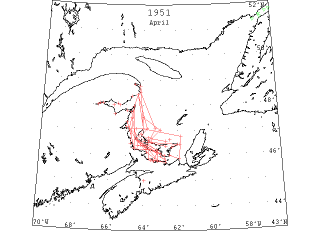
Apr The Canadian Department of Transport discontinued aerial surveys in the Gulf of St. Lawrence on April 30, reporting all routes to river and maritime ports clear for navigation. The extreme eastern limits of scattered ice observed by this service during the entire season were sighted in early March from Heath Point Anticosti to the Magdalene Islands, a marked difference from the normal. (IIP p7)
Apr 1 DOT aerial survey: Bay of Chaleur opening, but Bonaventure, Dalhousie, Bathurst frozen. (CIS IC0928)
Apr 1 DOT aerial survey: Charlottetown, Pictou, Summerside harbours open but ice in Strait. Route through Northumberland Strait navigable to Charlottetown today. Wood Island to Point Prim about 30% ice, Point Prim to Borden 50%, Borden to West Point and along New Brunswick coast about 80% ice. (CIS IC0945)
Apr 1 DOT aerial survey: Route via Strait of Canso and East Point, PEI navigable with open ice 5 miles off East Point. Souris Harbour open but ice in strait. M (CIS IC0980)
Apr 1 DOT aerial survey: South coast of Newfoundland clear. (CIS IC1043)
Apr 1 DOT aerial survey: E and S coast of Cape Breton clear. (CIS IC1054&IC1084)
Apr 1 DOT aerial survey: Ice in gulf today is confined in area W of line from Bonaventure Island, Gaspe, to North Point, PEI, to 20 miles NNE of East Point, PEI to Cape George. (CIS IC0738_2)
Apr 1 DOT aerial survey: Gaspe frozen. (CIS IC0754)
Apr 1 DOT aerial survey: Over steamer track Fame Point to N of Bird Rock to Cabot Strait no ice. (CIS IC0789)
Apr 2 DOT aerial survey: Dalhousie clear. River to Campbellton solid. (CIS IC0928)
Apr 2 DOT aerial survey: Ice is close packed up the New Brunswick coast to Bay of Chaleur. (CIS IC0781)
Apr 2 DOT aerial survey: Over steamer track Fame Point to Bird Rocks through Cabot Strait clear. (CIS IC0789)
Apr 2 DOT aerial survey: Magdalens clear; some scattered ice to 20 miles NNE of East Point then clear to river. Ice is closed packed on N coast of PEI. (CIS IC0828)
Apr 4 DOT aerial survey: Northumberland Strait clear to Bay Verte except for narrow band from East Point to Rollo Bay West of Borden to Egmont large fields of loose drift along the island side. Cape Egmont to West Point same as last report. West Point to North Point strip of clear water along the PEI coast about 5 miles wide, thence ice extends toward the new Brunswick coast to the end of visibility, close packed ice. Walagash harbour open some loose drift ice navigable in daylight, entrance clear. (CIS IC0945_2)
Apr 4 DOT aerial survey: Northumberland Strait clear to Bay Verte except for narrow band of shore ice extending from East Point to Rollo Bay on half to 1 mile wide, this ice is close pack, closing Souris harbour.
Apr 4 DOT aerial survey: Ice on N coast of PEI extends from North Point to 28 miles N of North Point thence to 47°00’N 63°00’W thence in a SW direction to shore. (CIS IC0828)
Apr 5 DOT aerial survey: Ports on N side of Bay of Chaleur opening up, Bathurst and Dalhousie, no change. Loose ice in mouth of Bay of Chaleur. (CIS IC0928)
Apr 5 DOT aerial survey: Summerside to Cape Egmont 50% ice, thence to West Point and across to the New Brunswick coast 85% ice extending N to Miscou. Ice moving very slowly out of Bay Verte, entrance nearly closed, Port Elgin harbour clear. Loose scattered drift from St. Peters Island to Borden, navigable with caution. Seacow Head to Cape Egmont 50% loose drift. Walagash harbour, clear today except for a few scattered pieces around the dock. (CIS IC0945_2-IC0945_3)
Apr 5 DOT aerial survey: Route Strait of Canso, East Point, PEI to River clear. (CIS IC0968)
Apr 5 DOT aerial survey: Gaspe inner harbour closed, entrance scattered drift. (CIS IC0754)
Apr 5 DOT aerial survey: Ice on New Brunswick coast starts at Cape Espoir crossing the mouth of Bay of Chaleur with loose drift thence heavy drift ice from Miscou Island to Buctouche. The outside limits of this appears to run from Cape Espoir to North Point but these limits are difficult to observe accurately due to low fog rising off the ice. (CIS IC0781)
Apr 5 DOT aerial survey: Ice off N coast of PEI unchanged since yesterday. Clear all around Magdalens. (CIS IC0828)
Apr 7 DOT aerial survey: Ports in Bay of Chaleur opening, Bonaventure, New Carlisle, Chandler scattered ice. Dalhousie and river open half way to Campbellton. (CIS IC0928)
Apr 7 DOT aerial survey: Northumberland Strait clear to Pictou and Charlottetown with loose drift St. Peters Island to Borden. (CIS IC0945_3)
Apr 7 DOT aerial survey: Little change in ice field W and S of lines from Bonaventure to 30 miles E of North Point to vicinity of Malpeque, no ice sighted E of these lines.
Apr 9 DOT aerial survey: Caraquet full, Bathurst, Shippigan, Dalhousie, open, scattered in approaches. (CIS IC0928)
Apr 9 DOT aerial survey: West of Borden ice more closely packed extending up the New Brunswick coast to Miscou, not navigable. (CIS IC0945_3)
Apr 9 DOT aerial survey: Northumberland Strait navigable to Souris, Georgetown. (CIS IC0980)
Apr 9 DOT aerial survey: Gaspe being broken by icebreaker “C.D. Howe”. (CIS IC0754)
Apr 9 DOT aerial survey: Over steamer track Fame Point to Bird Rocks through Cabot Strait clear. (CIS IC0789)
Apr 10 DOT aerial survey: Dalhousie and river clear to 7 miles above Dalhousie, New Carlisle clear. Bathurst and Shippigan open scattered in approaches. (CIS IC0944_2)
Apr 10 DOT aerial survey: Northumberland Strait navigable to Souris, Georgetown, Pictou, Charlottetown, thence to Borden scattered ice becoming closely packed W of Summerside and extending up the New Brunswick coast to Miscou close packed at Escumiac. (CIS IC0945_3 & CIS IC0800)
Apr 10 DOT aerial survey: Route via Strait of Canso, East Point, PEI to River clear. (CIS IC0968)
Apr 10 DOT aerial survey: Only ice of any consequence is located W of lines from Cape D’Espoir to 10 miles E of North Point, PEI to vicinity of Alberton and this is rapidly diminishing. (CIS IC0738_2)
Apr 10 DOT aerial survey: From Heath Point and a point 40 miles E of Heath Point, clear in all directions to end of visibility, 30 miles. (CIS IC0847)
Apr 10 First arrival of season at Quebec. (WBB)
Apr 11 DOT aerial survey: River St. Lawrence navigable today to Montreal. (CIS IC0738_2)
Apr 12 DOT aerial survey: Considerable ice still in bay [of Chaleur]. (CIS IC0944_2)
Apr 13 DOT aerial survey: Loose drift from Caribou to Wallace, Malagash closed across mouth of harbour. Bay Verte full of close packed ice. Strait blocked from Borden to Cape Egmont with heavy drift ice. From Cape Egmont ice veers across to 15 to 5 miles off the New Brunswick coast and holds this to the end of visibility off Richibucto. (CIS IC0945_4)
Apr 13 DOT aerial survey: Ice off N coast of PEI starts at Alberton harbour and extends in a line to Cape Tryon. This ice is close packed. 2 Sealers in ice of Malpeque. (CIS IC0828_2)
Apr 14 DOT aerial survey: Scattered fields from 5 miles off Caribou light to 5 miles off Point Prim. Entrance to Charlottetown harbour loosed drift ice navigable with caution. Strait not navigable W of Charlottetown. Heavy drift ice from 3 miles off St. Peters Island to West Point, almost close packed on the island side. New Brunswick coast loose drift. Ice veers off from West loose drift ice 5 to 15 miles wide extending northward to 10 miles off Tracadie light. (CIS IC0945_4)
Apr 14 DOT aerial survey: Ice of N coast of PEI same as yesterday but slackening off. (CIS IC0828_2)
Apr 15 DOT aerial survey: Route through Bay of Chaleur to New Carlisle, Bathurst, Bonaventure, Shippigan and Dalhousie navigable. (CIS IC0944_2)
Apr 15 DOT aerial survey: Route via Cabot Strait, Bird Rocks and Strait of Canso via East Point to Magdalens and River St. Lawrence clear. (CIS IC0738_3)
Apr 15 DOT aerial survey: Gaspe harbour now navigable. (CIS IC0754)
Apr 16 DOT aerial survey: Scattered drift ice in S side of Bay of Chaleur. Caraquet and Miscou breaking up. (CIS IC0944_2)
Apr 16 DOT aerial survey: Northumberland Strait clear from eastward to Souris, Georgetown, Montague, Pictou with open ice in entrance to Charlottetown. Continuous loosed drift from 2 miles E of St. Peters Island to West Point, PEI. Summerside and Egmont Bay close packed. (CIS IC0945_5)
Apr 16 DOT aerial survey: All ice loosening and moving E with brisk westerly winds. (CIS IC078_3)
Apr 16 DOT aerial survey: A wide strip of loose drift ice along New Brunswick coast to Tabisintac Gully. Miramichi Bay full of loose drift. (CIS IC0800)
Apr 16 DOT aerial survey: Ice pack on N coast of PEI yesterday has moved off shore and spread over a large area 10 miles off Malpeque. All ice loosening and moving E with brisk westerly winds. (CIS IC0828_2)
Apr 16 DOT aerial survey: W coast of Newfoundland clear to Bay of Islands. (CIS IC0847)
Apr 17 DOT aerial survey: Little change in conditions today. (CIS IC0738_3)
Apr 18 DOT aerial survey: Scattered drift between Charlottetown and Malagash. From Charlottetown west, loose and scattered drift on the New Brunswick side to Shediac Bay. Summerside harbour and Egmont Bay close packed extending along the island shore to West Point, PEI. Field of loose drift 4 miles long and 1 mile wide 15 miles W of North point, PEI. Large field of loose ice between Cape Tryon and St. Peters about 5 to 10 miles off shore. Ice in strait is moving E rapidly. (CIS IC0945_5)
Apr 18 DOT aerial survey: Except for ice in far NE area in gulf the only ice liable to obstruct navigation is located in Bay of Chaleur, S side, and along New Brunswick and the Northumberland Strait from Escumiac southward to vicinity of Point Prim also off N coast of PEI. (CIS 0738_3)
Apr 19 51°19’N 57°07’W. Berg. (IIP p12#131)
Apr 19 51°25’N 56°40’W. Berg. (IIP p12#132)
Apr 19 51°31’N 56°43’W. Berg. (IIP p12#133)
Apr 19 51°42’N 56°03’W. Berg. (IIP p13#134)
Apr 19 51°38’N 56°18’W Growler (IIP p13#141)
Apr 19 DOT aerial survey: Ice still obstructing Caraquet and Shippigan. (CIS IC0944_2)
Apr 19 DOT aerial survey: Northumberland Strait clear east of Wood Island. Scattered drift from there to Point Prim with entrance to Charlottetown closing up. Continuous heavy drift extending southward from St. Peter Island to Cape John and westward to Tormentine, thence along PEI side to West Point. Borden, Summerside and Egmont Bay close packed with New Brunswick shore navigable to Shediac. (CIS IC0945_6)
Apr 19 DOT aerial survey: Ice field reported yesterday on the N side of PEI is now located 10 miles off Shipwreck Point and rapidly dissipating. (CIS IC0828_2)
Apr 21 DOT aerial survey: Caraquet, Shippigan and Miscou harbours considerable ice. Bonaventure and Maquereau clear. (CIS IC0944_2)
Apr 21 DOT aerial survey: Northumberland Strait clear from eastward to Pictou, Charlottetown, continuous drift ice from Caribou to Pugwash 2 to 5 miles wide veering across Strait to Borden. From Borden W to Egmont Bay almost full width of Strait, Summerside closed, ice moving slowly eastward. (CIS IC0945_6)
Apr 21 DOT aerial survey: Except for ice in far NE area of gulf and Straits of Belle Isle only ice obstructing navigation is located in Bay of Chaleur and Northumberland Strait. Ice field previously located on N side of PEI seems to have disappeared. (CIS IC0738_4 & CIS IC0828_2 )
Apr 22 DOT aerial survey: Light winds, little change in ice conditions. (CIS IC0738_4)
Apr 23 DOT aerial survey: In Bay of Chaleur scattered ice moving about with different winds, navigable. Caraquet clear. (CIS IC0944_3)
Apr 23 DOT aerial survey: In Northumberland Strait east limits of ice a line from Cape Bear, PEI to Cape George, N.S. West of this line to Cape John scattered drift all over strait thence to Borden loose drift. Borden to Egmont Bay ice packing on island side. Summerside closed, clear along the New Brunswick coast. West end navigable along N.B. side to Tormentine. E end navigable with caution to Pictou. Strong S winds packing ice on island side, close observations show numerous heavy pieces. (CIS IC0945_6-IC0945_7)
Apr 23 DOT aerial survey: River and Gulf of St. Lawrence clear for navigation to Montreal, Chicoutimi, Gaspe and ports in Bay of Chaleur and Gulf. (CIS IC0738_4)
Apr 23 A three masted schooner reported caught in ice off Casey Cape, New Brunswick. (Pat 23 Apr p1 c6)
Apr 24 DOT aerial survey: Only ice obstructing navigation in gulf is located in Northumberland Strait, and this is rapidly disintegrating leaving today only a strip 1 to 3 miles wide along the island side from St. Peters Island to Egmont Bay, and it is getting pretty soft. This ice is expected to move out without causing much blockage. Northumberland Strait is navigable throughout on the New Brunswick side. Indications are that this ice will not cause much trouble, only to the fishermen who want to get their nets out. (CIS IC0945_7)
Apr 24 DOT aerial survey: Except for ice in far NE area of gulf and Strait of Belle Isle only ice obstructing navigation in gulf is located in the Northumberland Strait and this is rapidly disintegrating. (CIS IC0738_4)
Apr 25 All parts of Strait are now navigable. Only ice left is between Charlottetown and West Point. (Pat 25 Apr p1 c2)
Apr 27 DOT aerial survey: Strong northerly winds and gales today have broken up most of this ice and moved balance over on S side of strait from whence it is expected to disappear shortly. Summerside and Charlottetown harbours clear. (CIS IC0945_8)
Apr 27 DOT aerial survey: Except for ice in far NE area of gulf and Strait of Belle Isle only ice obstructing navigation in gulf is located in the Northumberland Strait and this is rapidly disintegrating. (CIS IC0738_5)
Apr 28 DOT aerial survey: Navigation is now possible to all PEI ports. (CIS IC0738_5)
Apr 30 DOT aerial survey: All routes to River, Gulf and Maritime ports except the Strait of Belle Isle now clear for navigation. (CIS IC0738_5)
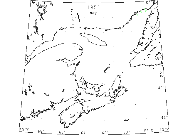
May 3 DOT aerial survey: IIP reports today 3rd that N Atlantic Track G, via Strait of Belle Isle now considered navigable and open for traffic. (CIS IC0738_5)
May 9 First Westbound steamer through the strait of Belle Isle. (WBB)
May 18 51°08’N 58°18’W Berg (IIP p14 #220)
51°17’N 57°53’W Berg (IIP p14 #221)
51°21’N 57°22’W Berg (IIP p14 #222)
May 19 51°30’N 57°30’W Berg (IIP p14 #224)