1946 Season
Nov 1 Last eastbound steamer through the Strait of Belle Isle. (WBB)
Dec 17 Last departure of the season from Quebec. (WBB)
Dec 31 Georgetown – SS “Lorne Park” sailed from this port on Christmas morning for Cuba. The ferry boat “Montague” is still making regular trips. SS “Meigle” arrived at this port on Monday (31st Dec). SS “Sorel” was in port for a few days last week. SS “Ulna” sailed from here on Christmas day for Sydney, N.S. (Pat 3 Jan 1946 p8 c3)

Jan 9 The CGS “Sorrel” arrived in port yesterday to land buoys. She is expected to leave tomorrow. (Pat 10 Jan p8 c3)
Jan 15 Georgetown – Ferry boat “Montague” completed her service for the season on Tuesday, January 15th, a week earlier than last year. (Pat 22 Jan p3 c3)

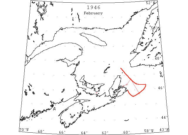
Feb In February the St. Lawrence ice began to move out of the Cabot Strait and on the 12th its eastern edge was reported about 50 miles NE of Scatari Island. By the 27th close packed ice extended eastward from Cape Breton to the 58th meridian. Few reports were received of the southern limits of this ice but it is estimated that it reached a latitude of about 45°30’N. (IIP)
Feb 11 N.A.T.S. Plane: Field ice northeastward from Cape Breton Island, outer limits not noted. (IIP p143#7)
Feb 12 N.A.T.S. Plane: Eastern limit field ice 46°25’N 58°50’W, eastern 20 miles broken and scattered. Southern limit (estimated 50 miles S) 45°35’N (estimated) west of 59°10’W. Heavy 10/10 cover. (IIPp143 #8)
Feb 15 Borden train delayed; as the ferry was delayed about an hour in making the crossing due to heavy ice in the Strait. (Pat 15 Feb p8 c4)
Feb 24-25 U.S.C.G.C. ”Laurel” encountered newly formed ice 8” thick from 46°18’N 60°07’W to 46°23’N 59°46’W, then heavy field ice 1’ to 4’ thick in pans up to 60’ in diameter to 46°45’N 59°22’W, then slob ice to 45°45’N 58°35’W. (IIP p144#17)
Feb 27 Ice Patrol Plane: eastern edge field ice 46°19’N 57°55’W, outer 5 miles strings and patches then close packed (conditions and visibility limited patrol). (IIP p144#18)

Mar The St. Lawrence ice coming out of Cabot Strait spread eastward during the first part of the month until by the 11th it had reached the 57th meridian between the 46th and 47th parallels. Between the eastern edge and Cape Breton Island the southern edge fluctuated between 46°N and 45°30’N during this period. During the latter part of the month the eastern edge of the ice receded westward and the southern edge moved southward until at the end of the month it was at about latitude 45°N between longitudes 58° and 60°W. (IIP)
Mar 1 Ice Patrol Plane: Limits main field from northwest to 46°13’N 57°20’W to 45°34’N 58°05’W to 45°20’N 58°41’W to 45°22’N 60°00’W. Outer limits scattered strings and patches light field ice from 46°50’N 57°45’W to 46°25’N 57°20’W to 46°00’N 57°23’W to 45°18’N 58°16’W. Along Cape Breton Island extending to beach at Cape Gabarus and southward past Cape Canso: light slob ice with some scattered pans vicinity Cape Gabarus decreasing in numbers southward. Believe navigable. (IIP p145#21)
Mar 2 No known ice S or E of a line connecting 46°25’N 57°20’W to 45°15’N 58°15’W to 45°20’N 60°20’W, except narrow belt light slob ice extending undetermined distance S past Canso. (HB #2948 Mar 9)
Mar 11 Ice Patrol Plane: Outer limits of field ice from 5 miles off Flint Island to 46°05’N 59°22’W to 45°32’N 59°42’W to 46°00’N 59°12’W to 46°04’N 59°00’W to 45°49’N 58°40’W to 45°56’N 58°30’W to 45°50’N 58°11’W to 46°03’N 57°53’W to 45°43’N 57°38’W to 45°54’N 57°36’W to 46°06’N 57°03’W to 46°52’N 56°53’W to Burgeo Bank eastern 20 miles scattered strings and patches. Center of field 7/10 to 10/10 cover with pans up to 100’ in diameter. (IIP p147#55)
Mar 12 Ice Patrol Plane: Belle Isle Strait between 59°W and 60°W; area open water and broken pans light winter ice extends 20 to 30 miles from Labrador – Quebec coastline thence open field ice becoming closely packed 50 to 60 miles offshore. Conditions near Newfoundland coast nor observed. (IIP p147#56)
Mar 13 “Fort Townshend” 45°10’N 58°00’W strings slob ice extending northward. (IIP p147#57)
Mar 13 Unknown source: Patches and strings of heavy field ice with very large pans from 45°26’N 58°50’W to 45°13’N 58°31’W to 45°26’N 57°43’W. (IIP p147#59)
Mar 13 From 46°12’N 59°28’W to 46°05’N 59°20’W to 45°35’N 59°49’W to 45°26’N 58°50’W to 45°10’N 58°00’W to 45°26’N 57°43’W to 46°06’N 57°05’W to 46°52’N 56°48’W, thence toward Burgeo Bank. Eastern edge of main pack ice at 56°10’N [46°10’N?] 57°05’W with at least 7 bergs indicated by radar in vicinity to westward. Strings slob ice extending to northward from 45°10’N 58°00’W. Patches and strings heavy drift ice with very large pans and lumps from 45°26’N 58°50’W to 45°13’N 58°31’W to 45°26’N 57°43’W. (HB #2950 Mar 23)
Mar 16 “Random” loose heavy ice 45°40’N 59°52’W to 44°44’N 57°34’W. (IIP p147#71)
Mar 16 From 46°12’N 59°28’W to 46°05’N 59°20’W to 45°35’N 59°49’W to 45°26’N 58°50’W to 45°10’N 58°00’W to 46°06’N 57°05’W to 46°52’N 56°48’W thence toward Burgeo Bank. (HB #2950 Mar 23)
Mar 17 “Fort Townshend” scattered strings slob ice 44°50’N 57°27’W to 44°35’N 58°01’W. (IIP p147#72)
Mar 17 From 46°12’N 59°28’W to 46°05’N 59°20’W to 45°35’N 59°49’W to 44°35’N 58°01’W to 44°50’N 57°27’W to 46°52’N 56°48’W thence toward Burgeo Bank. (HB #2950 Mar 23)
Mar 18 Unknown: field ice 44°45’N 57°10’W. (IIP p147#83)
Mar 21 N.A.T.S. Plane: Eastern edge field ice from 45°10’N 59°00’W to 46°05’N 56°47’W. (IIP p148#126)
Mar 21 From 46°12’N 59°28’W to 46°05’N 59°20’W to 45°35’N 59°49’W to 44°35’N 58°01’W to 44°45’N 57°10’W to 45°30’N 57°10’W to 46°29’N 57°10’W to 47°33’N 59°06’W. (HB #2951 Mar 30)
Mar 29 DOT aerial survey: Clear water along S side of Northumberland Strait from Cape Tormentine westward. (CIS IC0935)
Mar 29 DOT aerial survey: Close packed ice extends from 15 miles 150° from Bonaventure Island to 47°35’N 63°55’W. (CIS IC0779)
Mar 29 DOT aerial survey: Southward from 47°35’N 63°55’W to PEI clear water. (CIS IC0822)
Mar 30 DOT aerial survey: Westward from Cape George to Pictou Island to Amet Island some patches and strings. Pictou harbour clear. N side of Northumberland Strait clear to South Point with large sheets in Hillsborough Bay. Northumberland Strait considered navigable with caution from Pictou Island westward. (CIS IC0935)
Mar 31 Eastern edge of St. Lawrence ice from 7 miles W of Cape Ray to 47°18’N 59°11’W. Estimate only: scattered patches outside line from Scatari Island to Scatari Bank to 46°30’N 58°10’W to 7 miles off Cape Ray. (HB #2952 Apr 6)

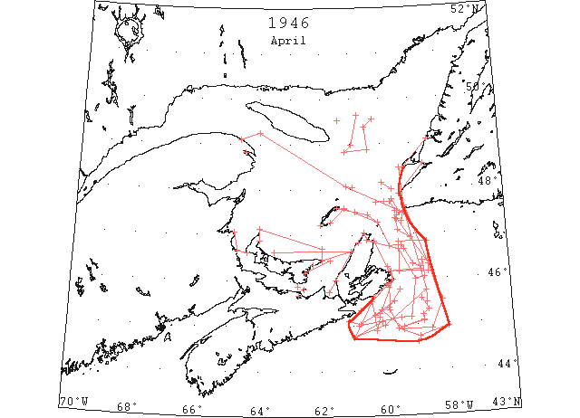
Apr During the early part of the month the St. Lawrence ice coming out of the Cabot Strait began to undergo rapid deterioration. The southwestern end of this ice moved to about the 61st meridian 30 miles S of Cape Canso but offered little hindrance to navigation. As is usual, Cabot Strait cleared first along the Cape Ray side and during the second week in April navigation into the gulf along the Cape Ray – Bird Rocks route was possible. By the 17th practically no ice remained south of a line from St. Paul Island to the Magdelen Islands and only a few unimportant narrow strings remained off shore from Flint Island to Cape Canso. (IIP)
Apr 2 “Fort Amherst” encountered strings of field ice 44°37’N 59°00’W to 44°55’N 58°00’W (IIP p150#270)
Apr 2 Ice Patrol Plane: Inner edge field ice from Cape Egmont with 3 to 6 mile shore lead to Giboux Island to Cunet Point thence 1 to 3 mile shore lead to Scatari Island. (IIP p150#301)
Apr 2 Ice Patrol Plane: Outer limits field ice from North Point Scatari Island to 45°49’N 59°51’W to 45°20’N 59°51’W to 44°55’N 59°35’W to 44°45’N 58°55’W to 44°57’N 58°02’W to 46°20’N 58°35’W to 47°20’N 59°32’W thence curving northward. An area of open water estimated up to 40 miles wide extends W and NW from St. Paul’s Island. Extent not determined. (IIP p150#302)
Apr 2 Ice Patrol Plane: Strings and patches field ice from beach at Cape Ray south to 47°18’N 59°22’W. (IIP p150#303)
Apr 2 Ice Patrol Plane: Belt 4 miles wide Cape Ray to Cape Anguille thence widening to 10 miles along S side of St. George Bay. 15 mile inshore lead from Cape St. George widening N of 49°N; field ice closely packed against beach. Area of open water NW from St. George Bay and N of line 307° degrees true from 48°N, 59°40’W. (IIP p151#304)
Apr 2 DOT aerial survey: From Cape Ray ice extends in a southerly direction to 45°32’N 58°10’W to 44°54’N 58°33’W to 44°54’N 59°26’W to 45°20’N 60°07’W to Scatari. (CIS IC0905)
Apr 2 DOT aerial survey: Northumberland Strait navigable West Point to Pictou Island. Some drift in Pictou Harbour and approaches. (CIS IC0935)
Apr 2 DOT aerial survey: George Bay close packed ice extending up the W coast of Cape Breton to Cape North. Not navigable at present. (CIS IC0982)
Apr 4 N.A.T.S. Plane: Eastern edge of field ice 45°45’N 58°40’W extending N to S becoming thin 15 miles to S. Width of field 60 miles. (IIP p151#305)
Apr 4 DOT aerial survey: Outside edge of ice runs from Cape North to 46°40’N 59°30’W to 30 miles E of Scatari to 45°10’N 59°10’W, 59°30’W[?] to 45°00’N 60°50’W on the western end of this field inside edge is 10 miles off Canso to 5 miles off St. Esprit to about 2 miles off Louisburg. (CIS IC0905)
Apr 4 DOT aerial survey: Ice in Pictou Harbour, Charlottetown harbour clear. (CIS IC0935)
Apr 4 DOT aerial survey: Over steamer track from Fame Point to 15 miles N of Bird Rock to 10 miles off Cape Ray some scattered ice but navigable with caution. (CIS IC0786)
Apr 4 DOT aerial survey: Pleasant Bay clear. (CIS IC0822)
Apr 4 Buoys ready for Charlottetown Harbour (but not placed yet). Last year buoys were placed on April 15th and 16th. (Pat 4 Apr p1 c5)
Apr 6 DOT aerial survey: Route to Father Point via Cape Ray, Bird Rocks, Fame Point now practically clear and navigable. (CIS IC0786)
Apr 8 DOT aerial survey: Summerside clear. (CIS IC0935)
Apr 8 DOT aerial survey: Gaspe solid. (CIS IC0766)
Apr 8 DOT aerial survey: Route today from 10 miles off Cape Ray to 10 miles off Cape Anguille to 15 miles off Bird Rocks to 10 miles off Fame Point. (CIS IC0786)
Apr 8 Airline flight from … spotted 8 fishermen from an ice bound schooner about 7 miles off the northern coast of Cape Breton struggling with a dory in an endeavour to reach shore. (Pat 6 Apr p5 c4)
Apr 9 Ice Patrol Plane: Southwestern limit of field ice 46°17’N 59°53’W to Flint Island to outer tip of Scatari Island to 45°54’N 59°52’W to 45°31’N 60°25’W to 44°53’N 60°17’W to 45°11’N 60°10’W to 45°15’N 60°10’N thence unobserved. (IIP p151#329)
Apr 9 Ice Patrol Plane: Southern edge of field ice 45°05’N 58°48’W to 44°57’N 59°25’W to 45°06’N 58°47’W to 45°13’N 58°49’W to 45°19’N 58°38’W to 45°34’N 58°50’W thence unobserved. (IIP p151#330)
Apr 9 Ice Patrol Plane: Eastern edge of field ice 46°00’N 59°00’W to 46°03’N 58°43’W to 46°25’N 58°46’W thence unobserved. (IIP p151#331)
Apr 9 Ice Patrol Plane: Northeastern edge of field ice 46°55’N 59°07’W to 47°06’N 59°31’W to 47°21’N 59°35’W to 47°28’N 59°25’W to 47°46’N 59°40’W to 47°43’N 59°45’W to 47°31’N 59°35’W thence curving westward. (IIP p152#332)
Apr 9 Ice Patrol Plane: Southern edge of field ice separated from the above field [#332] by open water the westward extent of which not determined 47°43’N 60°12’W to 47°43’N 59°55’W thence trending northward with shore lead past Cape St. George. St. George Bay ice free. (IIP p152#333)
Apr 9 First arrival of season at Quebec. (WBB)
Apr 10 DOT aerial survey: Ice area S of line from North Point, PEI to Entry Island to 10 miles off East Point, Magdalens to St. Pauls, ice extends to the N side of PEI and W coast of Cape Breton. (CIS IC0822)
Apr 12 DOT aerial survey: Northumberland Strait navigable from West Point eastward to Cape George. (CIS IC0935)
Apr 12 DOT aerial survey: There is a large volume of ice on the N side of PEI and surrounding the island of Cape Breton. (CIS IC0822)
Apr 13 N.A.T.S. Plane: Southern limits of field ice 44°44’N 61°00’W to 45°05’N 60°05’W; strings extending approximately 5 miles southerly and easterly direction from field. (IIP p152#371)
Apr 13 DOT aerial survey: Magdalens clear except at Amherst and Pleasant Bay ¾ full. (CIS IC0823)
Apr 14 From Scatari Island to 45°31’N 60°25’W to 44°44’N 61°00’W to 45°00’N 60°00’W to 45°45’N 58°40’W to 8 miles off Cape Ray with shore lead past Cape St. George. (HB # 2954 Apr 20)
Apr 15 N.A.T.S. Plane: NE coast Cape Breton Island vicinity Flint Island, strip field ice 5 to 6 miles wide (pilots noted ships proceeding through this ice to Sydney). (IIP p153#386)
Apr 15 DOT aerial survey: [Northumberland Strait] Eastern end blocked. Some loose ice across western entrance from West Point to the New Brunswick shore extending northward to Escumiac. (CIS IC0935_2)
Apr 15 DOT aerial survey: Over steamer track Cap des Rosiers to Cape Ray clear. Small patch 15 miles 033° from Bird Rocks. (CIS IC0786)
Apr 15 DOT aerial survey: Fringe on N side of PEI. Ice field 15 miles wide extends from Cape Kildare to East Point then northward to the Cape Breton coast. Close packed ice around East Point. (CIS IC0823)
Apr 16 DOT aerial survey: Pictou harbour and approaches clear. (CIS IC0935_2)
Apr 17 Ice Patrol Plane: Axis of detached field 2 to 5 miles wide 45°06’N 61°09’W to 45°02’N 60°47’W to 45°24’N 59°53’W to 45°46’N 59°31’W. (IIP p155#489)
Apr 17 Ice Patrol Plane: Outer limits of remnants of ice field Flint Island to 46°13’N 58°49’W to 46°17’N 58°49’W to 46°21’N 59°05’W to 46°41’N 59°20’W to 46°45’N 59°25’W thence estimated to 46°45’N 59°48’W thence observed St Paul Island to 47°26’N 60°28’W to 47°30’N 60°53’W to East Island. 4/10 to 5/10 cover between Magdelen Islands and St. Paul Island increasing past Cape North to 10/10 in vicinity of Flint Island. (IIP p155#490)
Apr 17 Ice Patrol Plane: 2 very narrow strings of field ice 25 miles NNE of East Cape, Anticosti Island. (IIP p155#491)
Apr 17 Ice Patrol Plane: Series of crescent shaped strings, area enclosed by line 49°38’N 60°45’W to 48°59’N 60°58’W to 48°50’N 61°12’W to 48°53’N 60°26’W to 49°22’N 60°31’W thence NE; cover less than 3/10 within these limits. (IIP p155#492)
Apr 17 DOT aerial survey: Large ice field within the following positions, 45°32’N 59°42’W, 45°14’N 60°19’W. This field is approximately 35 miles long, 15 miles wide moving south. (CIS IC0905)
Apr 17 Area from Magdalen Islands to Anticosti Island ice free. (HB #2955 Apr 27)
Apr 17 Sydney, C.B. – last week the tanker “Transriver” entered the harbour after battering heavy ice off the Cape Breton coast. (Pat 24 Apr p1 c3)
Apr 19 DOT aerial survey: Large field between latitude 46°10’N and 46°50’N and longitudes 58°35’W and 59°30’W with string 1 miles wide connecting Scatari Island. (CIS IC 0905)
Apr 19 The first steamer to arrive in Summerside this season came into port on Friday afternoon (April 19th). Owing to ice conditions at Gaspe, the steamer will remain there until Gaspe is free of ice. (Pat 24 Apr p8 c4)
Apr 22 Scattered strings and patches E and S of Cape Breton Island. (HB #2956 May 4)
Apr 24 DOT aerial survey: Strait of Canso is clear but passage through Northumberland Strait doubtful. (CIS IC0935_2)
Apr 24 DOT aerial survey: Cheticamp, no ice in sight. (CIS IC0982)
Apr 24 DOT aerial survey: Gaspe harbour clear. (CIS IC0766)
Apr 25 Vessel “Surewater” arrived last night, delayed due to fog. (Pat 26 Apr p5 c4)
Apr 26 DOT aerial survey: Northumberland Strait navigable throughout. (CIS IC0935_2)
Apr 26 Scattered strings and patches NE of Cape Breton Island. (HB #2956 May 4)
Apr 26 Little Sands – The ice has left the shores and the Strait is clear of ice. (Pat 26 Apr p8 c4)
Apr 28 DOT aerial survey: Ice is packed on E coast of PEI from Georgetown to 10 miles off East Point. Souris and approaches blocked. (CIS IC0978)
Apr 29 DOT aerial survey: Ice is moving off the E coast of PEI. Some scattered ice in Souris harbour and approaches. (CIS IC0978)
Apr 29 The steamer “Surewater” left (Charlottetown) about noon for St. John’s, Newfoundland. (Pat 29 Apr p5 c4)
Apr 30 Last DOT flight of the season. (Pat 27 Apr 1959 p3 c2)
May 25 First Westbound steamer through the strait of Belle Isle. (WBB)