1945 Season
Oct 31 Last eastbound steamer through the Strait of Belle Isle. (WBB)
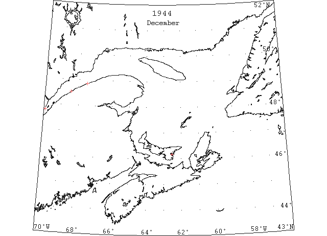
Dec By the 8th December light winter ice was reported in the St. Lawrence River from Quebec to Orleans Island. Ice was first reported down river to Cape Salmon on the 16th, at Father Point on the 19th and at Matane on the 27th. From these shore reports it is assumed that the ice in the river was considerably broken and comparatively open, shifting from shore to shore with the shifting winds and dissipating before reaching the gulf proper. (IIP 1946 p88)
Dec 8-14 Winter ice St. Lawrence River, Quebec to St. Jean, Orleans Islands. (IIP 1946 p101)
Dec 15 Winter ice Cape Bruly[Cap aux Bouleaux?] to Isle aux Candres[Ile aux Coudres?] (first report). (IIP 1946 p101)
Dec 16 Winter ice Cape Salmon (first report). (IIP 1946 p101)
Dec 17 Last departure of the season from Quebec. (WBB)
Dec 19 Winter ice Father Point (first report). (IIP 1946 p101)
Dec 27 Winter ice Matane. (IIP 1946 p101)
Dec 31 Georgetown – The ferry boat Montague made trips on Sunday, 31st. Ice has formed near the shore. (Pat 3 Jan 1945 p6 c3)
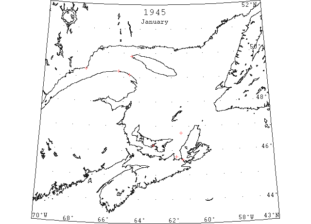
Jan By the 13th small amounts of river ice had passed Cape des Rosiers and scattered ice had drifted to the western tip of Anticosti Island. A plane flying over the lower St. Lawrence River reported ice everywhere from Father Point to Baie Comeau on the 14th and heavier ice was reported at Fame Point. No reports concerning the Gut of Canso – Northumberland Strait area were received until 22nd when closely packed ice was reported in George Bay and at the northern entrance of the Gut of Canso with heavy ice at times drifting back and forth through the gut. Sydney Harbour and approaches remained clear throughout the month and it is believed that little or no ice was to be encountered in the gulf from Anticosti Island outward through Cabot Strait. (IIP 1946 p88)
Jan 2 SS “Fairview” is still making trips to Rocky Point. Last sailing in 1944 believed to have been January 4th. (Pat 2 Jan p5 c3)
Jan 10 Man tumbles from Northumberland Strait ferry and falls on to ice floe. (Pat 10 Jan p4 c4)
Jan 11 Georgetown – The ferry boat Montague, made regular trips on the 11th inst. (Pat 16 Jan p6 c5)
Jan 13 First ice reported Point des Monts and West Point Anticosti. (IIP 1946 p101)
Jan 17 Winter ice Cape Magdalen (first report). (IIP 1946 p101)
Jan 19 Winter ice Fame Point (first report). (IIP 1946 p101)
Jan 22 Closely packed western entrance Gut of Canso and George Bay. Drifting in and out of Gut of Canso with wind and currents. (IIP 1946 p101)
Jan 26 Upper Chesapeake Bay, ice warnings. (HB #2891 Feb 3)
Jan 29 Car ferry PEI made a crossing in summer time on Saturday evening of 53 minutes. (Pat 29 Jan p5 c3)
Jan 31 The car ferry is making regular trips without interference from ice. (Pat 31 Jan p5 c3)
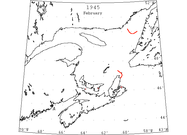
Feb Light local ice was formed in Sydney Harbour on the 7th but had disappeared by the 11th. Some slob and slush ice was reported in the Sydney approaches on the 6th and again on the 12th and 13th. At this time allied shipping was advises that use of Sydney Harbour was inadvisable for other than shipping normally docking at North Sydney. On the 14th the area through Cabot Strait westward to 61°W and northward to 49°N was clear of ice with the exception of light ice closely packed along the NW shore of Cape Breton Island extending to approximately 15 miles offshore at Cape St. Lawrence and terminating at Cape North. The area along the Newfoundland W coast was clear to over 60 miles off shore northward past Bonne Bay. Light field ice appeared off Sydney about the 17th but moved off beyond the limit of visibility by the 22nd. Winter ice again formed in Sydney Harbour on the 15th and remained throughout the remainder of the month but was becoming broken and scattered by the 28th. No information is available concerning off shore conditions during the latter part of the month N and E of Cape Breton Island and through Cabot Strait but subsequent reports indicate that no appreciable amount of field ice moved out through the strait and that such movement as had occurred was probably confined to a very narrow belt at the very southern edge of the strait drifting around Cape North. (IIP 1946 p88-89)
Feb 6 Souris Harbour was reported on Tuesday (Feb 6th) as still free of ice. (Pat 8 Feb p8 c3)
Feb 8 Light slob approaches to Sydney (not visible on 9th). (IIP 1946 p101)
Feb 9 Light winter ice upper reaches Sydney Harbor. (IIP 1946 p101)
Feb 9 The car ferry “Prince Edward Island” which left Borden yesterday afternoon got within a mile of Tormentine when she was compelled to return when unable to cope with the heavy ice. Today conditions were considerably improved. (Pat 10 Feb p5 c5)
Feb 10 General ice warning for Atlantic coast as far south as New Jersey. (HB #2892 Feb 10)
Feb 10-11Light slob Sydney Harbor (Disappeared by 12th). (IIP 1946 p101)
Feb 12-13Slush and slob approaches to Sydney (No ice visible on 14th). (IIP 1946 p101)
Feb 15-27Winter ice Sydney Harbor 8/10 covered. (Decreased 5/10 by 28th and disappeared on March 5). (IIP 1946 p101)
Feb 16 Slush and slob Sydney approaches. (IIP 1946 p101)
Feb 17 Ice in Georgetown Harbour. (Pat 17 Feb p8 c3)
Feb 18 Pancake ice Sydney approaches. (Disappeared on 23rd). (IIP 1946 p101)
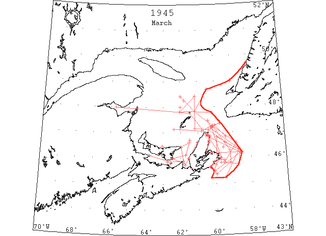
Mar The winter ice in Sydney Harbour disappeared by the 5th and except for light ice forming on the 12th and melting by the 15th, the harbour remained clear throughout the remainder of the season. Heavy field ice appeared off Sydney about the 6th and by the 8th when the first aerial observation was made over the area, the approaches to Sydney were completely blocked. The ice field was heavy and closely packed off Sydney becoming open and somewhat scattered toward its outer limits. At this time it had reached the most easterly extent noted during the season at 46°15’N 58°45’W. Between the 10th and the 13th the ice moved southwestward along the E coast of Cape Breton Island reaching its most southerly extent for the season at 45°12’N 60°10’W. Easterly winds had moved the ice inshore and from the 14th until the 23rd the ice moved in and out along the beach at Louisburg. By the 17th outer limits had receded westward past 60°10’W and northward past 45°20’N. The field was now rapidly receding for by the 25th only a few scattered strings remained S of Scatari Island and with the exception of a closely packed strip along the beach southward from Aspy Bay, the ice off the NE coast was open and scattered and passage to Sydney considered easily navigable by ice-worthy vessels. At no time during the month was Cabot Strait closed or the Newfoundland coast S of Bay of Islands endangered by field ice. The ice drifting through the strait was confined to a narrow belt passing along the S side of Cape North and the greatest northerly extent observed in the strait was in the vicinity of St. Paul Island. From there the edge curved westward to the vicinity of Bird Rocks. By the 22nd the ice in the river began to break up and by the last of the month the river was almost clear as far as Quebec. (IIP 1946 p89)
Mar 2 Slush and slob Sydney approaches. (IIP 1946 p101)
Mar 5 Northumberland Strait filled. Belt north of Prince Edward Island then open water towards center of Gulf. Strings of light field ice to 30 miles seaward ENE of Sydney. Estimated cover 5/10. (IIP 1946 p101)
Mar 6 Outer limits field ice from 5 miles offshore at Cape North to 45°50’N 59°30’W to 46°35’N 58°50’W thence in direction of St. Paul Island. Ice Open. (IIP 1946 p101)
Mar 8 Outer Limits field ice from Cape Breton to 45°50’N 59°42’W to 45°45’N 58°45’W to 46°16’N 58°36’W to 46°37’N 59°28’W to 47°07’N 60°24’W to vicinity 47°10’N 61°10’W thence curving northward to vicinity Bird Rocks to 48°42’N 60°25’W to 49°00’N 59°00’W to Newfoundland coast near 49°40’N. Ice scattered near southern and eastern edge (1/10 to 2/10 cover) increasing 6/10 to 10/10 cover in body of pack. Route and approaches to Sydney blocked. (IIP 1946 p101)
Mar 12 Winter ice forming in Sydney Harbor (8/10 cover on 13th: 5/10 slob ice on 14th. Ice disappeared by 15th. No further ice in harbor remainder of season). (IIP 1946 p101)
Mar 13 Area broken field ice extends from Gulf of St. Lawrence along east coast Cape Breton Island to limits: Scatari Island to 45°45’N 60°00’W to 45°15’ N 60°15’ W to 45°15’ N 59°30’ W to 46°20’N 58°40’W to 47°10’ N 60°15’W thence 340° true into Gulf. (IIP 1946 p101)
Mar 14-27 Louisburg approaches, heavy ice from 1 mile off shore to limit of visibility. Closed to beach and filled harbor on 15th thence moved seaward to beyond limit of visibility 16th to 17th shifting to within 2 miles of beach on 18th thence seaward 19th to 21st then to within 3 miles on 22nd and closing on beach on 23rd with some ice drifting into harbor. Ice moved off shore on 24th for remainder of season but some drift ice remained within the harbor until 27 March. (IIP 1946 p101)
Mar 17 Outer limits field ice: 45°39’N 60°17’W to 45°23’N 59°57’W to 45°49’N 59°09’W to 46°17’N 59°12’W thence northerly to St. Paul Island and beyond toward Bird Rocks. Approaches and routes to Sydney blocked. Ice close on shore Flat Point, Scatari Island to Cape Breton. Gabarus Bay closed with scattered strings extending southward to Fourchu Point. (IIP 1946 p101)
Mar 20 DOT aerial survey: From East Point, PEI open water to 20 miles W of Cheticamp to 10 miles NW of Port Hood to Cape Bear. Other areas close packed ice, heavy drift ice passing through Strait of Canso. (CIS IC0991_2)
Mar 20 DOT aerial survey: Field of open ice along coast between Glace Bay and Cape Breton with southern edge extending to 58°30’N thence extending to 46°50’N 59°55’W to vicinity of Glace Bay. Eastern edge from 46°50’N 59°25’W to 5 miles E of St. Pauls to 25 miles SW of Cape Ray thence to 30 miles N of St. Pauls to Bird Rocks. (CIS IC1016_2)
Mar 20 DOT aerial survey: Close packed ice from Cape Smoky N along E coast to Cape Breton and along W coast. (CIS IC1019_3)
Mar 20 DOT aerial survey: An area of open water 5 miles wide from East Point, PEI westward as far as can be seen along N coast. (CIS IC0831)
Mar 23 Lower river clearing. No ice in sight at Father Point, Matane or Point des Monts. (IIP 1946 p101)
Mar 25 Outer limits scattered ice Cape North to 46°11’N 58°35’W to 45°30’N 60°05’W to beach near 45°40’N 60°20’W. Strip close pack 1 to 5 miles wide along coast from St. Anne Bay to Cape North. Remainder of field less than 3/10 cover diminishing to less than 1/10 scattered strings near outer edges. Sydney and Louisburg harbors easily accessible from seaward. Open water from a few miles off Cape St. Lawrence westward past Magdalen Islands. Southeast edge of ice in central part of gulf about 35 miles northwest of Bird Rocks. (IIP 1946 p102)
Mar 26 DOT aerial survey: George Bay pack ice extending westward to 4 miles NE of Cape George to 4 miles N of Pictou Island to Tormentine. Northumberland Strait clear throughout. Pictou harbour open from wharves to bar then narrow strips, then ½ mile of open water, then close pack ice, Hillsborough solid. (CIS IC0941_3)
Mar 26 DOT aerial survey: George Bay pack ice extending northward along W coast of Cape Breton and westward to 4 miles NW of Cape George to 4 miles N of Pictou Island.
Mar 26 DOT aerial survey: Southward from St. Anns Bay to Scatari to Union Island few scattered strings. (CIS IC1019_3)
Mar 26 DOT aerial survey: Ice is segregated in southern part of gulf, N edge S of a line from Bay of Chaleur to Brion Island to 4 miles N of Cape North to 14 off Cape Smokey to St. Anns Bay. (CIS IC0734_3)
Mar 26 DOT aerial survey: Route via Scatari, Cape Ray to St. Pauls, Bird Rocks, Father Point now navigable. Eastward from Cape des Rosiers over steamer route to Bird Rocks, to Cape Ray and St. Pauls to Scatari occasional strings. (CIS IC0770)
May 26 Ice reports apparently largely suspended during course of WW2 in HB, resumes in this issue. (HB #2907 May 26)
Mar 26 The Rocky Point Ferry established a record on Monday (March 26th) when the ship made the first trip of the season. Last year the boat did not make its first trip until April. (Pat 28 Mar 1945, p8 c3)
Mar 27 DOT aerial survey: Ice has moved off E coast of Cape Breton, none in sight at Aspy Bay, Sydney or Scatari. (CIS IC1019_3)
Mar 27 DOT aerial survey: No ice in sight at St. Pauls. (CIS IC1038)
Mar 27 DOT aerial survey: Louisburg some drift ice in harbour; approaches clear. (CIS IC1081_3)
Mar 28 DOT aerial survey: Open water along N side of Northumberland Strait, Pictou Island reports considerable light drift ice in that vicinity. (CIS IC0941_3)
Mar 28 DOT aerial survey: Heavy drift passing through Strait of Canso. (CIS IC0963_3)
Mar 28 DOT aerial survey: Close pack in George Bay extending up W coast of Cape Breton but open between Port Hood and Cheticamp. Open water from East Point, PEI to 5 miles NW of Cape George to E coast of PEI and along N side of Northumberland Strait. (CIS IC0991_2)
Mar 28 DOT aerial survey: Pan and slob ice west of line from 4 miles SW of St. Pauls to 2 miles E of Scatari navigable. (CIS IC1016_2)
Mar 28 DOT aerial survey: Northern edge of ice in gulf from 4 miles SW to St. Pauls to 15 miles NW of Cape North to 5 miles S of Magdalens then trending W. (CIS IC0734_3)
Mar 28 DOT aerial survey: Eastward from there [?] to Bird Rocks fairly clear, occasional strings and patches from Bird Rocks to 35 miles N and W. (CIS IC0770)
Mar 29 Georgetown – The ferry boat “Montague” began her services on March 29th, the earliest date in many years. The harbour is now clear of ice. (Pat 2 Apr p4 c5)
Mar 30 Few isolated strings between Bird Rocks and 48°25’N 62°00’W. Scattered ice south of St. Paul Island. Strips along shore at Aspy Bay, Sydney and Louisburg. Scattered ice in Gut of Canso with close pack at northern end and in George Bay. (IIP 1946 p102)
Mar 31 No ice in sight at Cape Salmon, Father Point, Matane, Cape Magdalen, or Martin River. (IIP 1946 p102)
Mar 31 DOT aerial survey: Pictou Harbour and approaches clear also strait in vicinity of Pictou Island. (CIS IC0941_3)
Mar 31 DOT aerial survey: Close pack ice to shore at Aspy Bay. (CIS IC1019_3)
Mar 31 DOT aerial survey: Scattered ice S of St. Pauls. (CIS IC1038)
Mar 31 DOT aerial survey: Louisburg harbour and approaches clear. (CIS IC1081_3)
Mar 31 DOT aerial survey: Northern edge of pack ice in 48°00’N 62°00’W extending southward. (CIS IC0752)
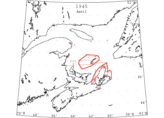
Apr By the 4th the river was clear to Quebec and was mostly clear from Quebec to Montreal. Only a few patches and a few scattered strings remained in the gulf and a few rotten strings in the area NE of Sydney. The Cape Ray – Bird Rocks route was navigable as far as Quebec. By the 8th the ice in George Bay and Northumberland Strait was mostly gone and that route was considered navigable. All points of the river and gulf were then free of ice with the exception of a little scattered ice in the vicinity of the Magdalen Islands and a small string just SE of St. Paul Island. Some local winter ice remained in the vicinity of Gaspe Bay, however, until 17th after which date the entire gulf and river area were free of ice.
This was an unusually light season in the St. Lawrence – Cape Breton Island area. Local freezing was exceptionally light as was evidenced by the reports concerning Sydney Harbour. The volume of ice drifting through Cabot Strait was exceptionally small and at no time did this ice endanger the shipping routes N of Sable Island. The ports on the Newfoundland S and SW coats were ice free throughout the season. The shipping routes to Louisburg were blocked for brief intervals two or three times by easterly winds moving the field ice to the beach but shifting winds created a shore lead and enabled ships to reach that part without considerable delay. The routes through the gulf and river to Quebec were free of ice and navigable earlier than during the average season. (IIP 1946 p89-90)
Apr 2 Ice coming down the West River did considerable damage to the west wing of the Rocky Point wharf. (Pat 2 Apr p5 c4)
Apr 3 DOT aerial survey: N side of Bay of Chaleur clear to beyond Carlisle with isolated strings and patches southward to Northumberland Strait. (CIS IC0926)
Apr 3 DOT aerial survey: E coast of PEI clear with few isolated strings off Cape George and N and W of Pictou Island. (CIS IC0979)
Apr 3 DOT aerial survey: Close pack in George Bay extending up W coast of Cape Breton about 5 miles wide N of Inverness. (CIS IC0998_2)
Apr 3 DOT aerial survey: Close pack between St. Pauls and Cape St. Lawrence with isolated strings and patches southward from St. Pauls to vicinity of Glace Bay. (CIS IC1016_2)
Apr 3 DOT aerial survey: Over steamer track from Fame Point to N of Bird Rocks to Cape Ray practically clear. Northern edge of ice from 40 miles NW of Magdalens to Brion Island to 47°30’N 61°00’W. (CIS IC0734_4)
Apr 4 Lower St. Lawrence River clear of ice from Quebec to Fame Point, practically clear from Montreal to Quebec. Northumberland Strait clear. Gulf of St. Lawrence mostly clear except areas as noted below:
Northeastern part of Gulf north of 49°N. Patch 5 miles in diameter vicinity 46°50’N 63°00’W. Strings 5 to 10 miles north of West Point, Prince Edward Island. Few strings between North Point, Prince Edward Island and Escuminac. Area of close pack from 47°10’N, to 47°30’N, between 63°20’W, and Magdalens. String of close pack along east coast Cape Breton Island from Aspy Bay southward. Patch 1 to 3 miles wide at Scatari Island. George Bay-close pack northward of line from Cape George to Henry Island to 10 miles northeast of Cape George and 8 miles north of Henry Island. Remainder of Bay loosening up, few strings. Steamer route via Cape Ray to Quebec navigable this date. (IIP 1946 p102)
Apr 4 DOT aerial survey: Loose packed ice and slush in a line N-S between Eddy Point and Cape Canso, with small floes S of Mulgrave. (CIS IC0963_3)
Apr 5 DOT aerial survey: George Bay loosening up. Only few strings in northeastern part but close pack N of a line from Cape George to Henry Island extending northeastward from Cape George. Ice in George Bay moving out and route via Strait of Canso and Northumberland Strait, East Point, should be navigable tomorrow. (CIS IC0956_2-IC0956_3)
Apr 5 DOT aerial survey: Close pack N of a line from Cape George to Henry Island extending northeastward from Cape George for 10 miles then westward to 8 miles N of Henry Island. Clear N and W. (CIS IC0992)
Apr 5 DOT aerial survey: Area of strings and loose pack bounded by 46°40’N 59°50’W, 46°20’N 60°10’W. Close pack 1 to 3 miles wide from Scatari to Sydney. (CIS IC1016_3)
Apr 5 DOT aerial survey: Strip of close pack along E coast of Cape Breton from Aspy Bay southward. (CIS IC1019_3)
Apr 5 DOT aerial survey: No ice in western part of gulf N of 47°30’N and W of 61°00’W. No ice in eastern part N of 47°00’N except in northeastern part N of 49°N. (CIS IC0734_4)
Apr 5 DOT aerial survey: Close pack strings 3 miles wide, 5 to 10 miles N of North Point, PEI. Few strings between Escumiac and North Point. Close pack area between 47°10’N 47°30’N and 63°20’W and Magdalens. (CIS IC0799)
Apr 5 DOT aerial survey: Patch in 46°50’N 63°00’W area 5 miles. (CIS IC0817)
Apr 6 DOT aerial survey: Isolated strings in Bay of Chaleur. (CIS IC0926)
Apr 6 DOT aerial survey: Northumberland Strait clear with Hillsborough Bay still solid. One ice string sighted about 10 miles S of Murray harbour. No ice between Pictou Island and PEI. (CIS IC0941_4)
Apr 6 DOT aerial survey: George Bay western half clear eastern filled with broken pan ice extending along coast to 4 miles off Port Hood. (CIS IC0956_3)
Apr 6 DOT aerial survey: Scattered pans in Strait of Canso. (CIS IC0963_3)
Apr 6 DOT aerial survey: Small patch 5 miles N of Cape North. Scattered light strings off E coast of Cape Breton between Cape Egmont and Sydney. (CIS IC1019_3)
Apr 6 DOT aerial survey: Gulf free of ice except for some wisely separated patches. (CIS IC0734_4)
Apr 6 DOT aerial survey: Isolated strings 15 miles NE of Bonaventure Island. Sighted few light floes about 15 miles SW of easternmost point in Anticosti. (CIS IC0752)
Apr 6 DOT aerial survey: String at 47°25’N 64°02’W extending E-W for 20 miles. Open and close pack on line from Brion Island to Bird Rocks extending E, W about 30 miles. Few strings off Mission Point becoming loose pack ice to Shippigan 5 miles off shore. (CIS IC0799)
Apr 6 DOT aerial survey: Few strings S of Magdalens to St. Pauls. (CIS IC0817)
Apr 7 Only few strings remain near Cape Breton coast. Outer limit less than 20 miles off shore.
Apr 8 Ice conditions George Bay improved. Route via Gut of Canso and Northumberland Strait now considered navigable. Scattered remnants in vicinity Magdalen Islands and St. Paul Island. All other points of river and gulf reported clear. (IIP 1946 p102)
Apr 8 DOT aerial survey: Conditions in George Bay have improved and route via Strait of Canso now navigable. (CIS IC0956_3)
Apr 8 DOT aerial survey: Route via Strait of Canso now navigable. (CIS IC0963_3)
Apr 9 DOT aerial survey: Narrow strip of ice along W coast of Cape Breton from North Canso NW to Port Hood 1 to 2 miles wide. Eastern coast of George Bay covered with pack ice 1 to 2 miles in extent, but to W no ice. (CIS IC0956_3)
Apr 9 DOT aerial survey: Ice thinning out, becoming scattered strings of pack and widely separated cakes through Strait of Canso and off Eddy Point. Navigation feasible. (CIS IC0963_3)
Apr 9 DOT aerial survey: Narrow strip of ice along W coast of Cape Breton from Margaree harbour northward and around Cape North. Little ice from Margaree harbour to Sight Point. Thin loose and pack ice ½ to 1 mile from shoreline from Sight Point to George Bay. (CIS IC0998_2)
Apr 9 DOT aerial survey: Narrow strip of ice along W coast of Cape Breton from Margaree harbour northward and around Cape North with isolated strings 5 to 10 miles off shore from Cape Egmont to Ingonish. Loose and scattered pack ice 3 to 4 miles N of Cape North on a line E-W 25 miles. (CIS IC1019_4)
Apr 9 DOT aerial survey: All areas in river and gulf now practically free of ice except Saguenay River, Gaspe harbour and W and E coasts of Cape Breton. Route via Strait of Canso, East point and Northumberland Strait now navigable. (CIS IC0734_4)
Apr 9 DOT aerial survey: No ice sighted N of PEI to position 47°05’N 62°10’W. (CIS IC0817)
Apr 9 First arrival of season at Quebec. (WBB)
Apr 10 DOT aerial survey: Scattered ice in Strait of Canso. (CIS IC0963_3)
Apr 12 DOT aerial survey: Strait of Canso completely free of ice. (CIS IC0963_3)
Apr 12 DOT aerial survey: One narrow string 4 miles long S from St. Pauls. (CIS IC1038)
Apr 12 DOT aerial survey: Very loose packed pan ice along W coast of Cape Breton, extending 2 to 4 miles off shore line from 45°50’N to Inverness. (CIS IC0998_2)
Apr 12 DOT aerial survey: Cabot Strait completely free of ice. (CIS IC1016_3)
Apr 12 DOT aerial survey: All points in river and gulf now free ice except strip of loose pack ice between Port Hood and Inverness, narrow strip off NW shore of Magdalens, very thin narrow strings extending SE from East Point, Magdalens, narrow string 4 miles long S of St. Pauls. As there is no ice sufficient to obstruct navigation flights will be discontinued (CIS IC0734_4-IC0734_5)
Apr 12 DOT aerial survey: Loose packed ½ to 4 miles inshore along northwestern shore of Magdalen Islands. Few strings between Magdalen Island and Brion Island. (CIS IC0799)
Apr 12-17 Few small strings and patches remaining 12th vicinity Magdalens, south of St. Paul Island, between Port Hood and Inverness, and vicinity Sandy Beach Spit and Northwest arm Gaspe Bay. All ice except that in vicinity Gaspe dissipated by 15th and the latter prior to the 17th of April. (IIP 1946 p102)
Apr 15/16 Buoys in Charlottetown Harbour placed on April 15th and 16th. (Pat 4 Apr 1946, p1 c5)
Apr 27 Covehead – There is no ice on the North Shore. (Pat 27 Apr p3 c5)
Apr 27 The shores are reported free from all ice and a successful (lobster) season is expected. (Pat 27 Apr p8 c3)
May 1 Lobster season opened May 1st – no mention of ice. (Pat 2 May p1 c6)