1944 Season
In summarizing, the 1944 ice season in the St. Lawrence area was less severe than an average year. The ice was late in forming in the early winter; the gulf broke out earlier than usual in the spring, the ice was relatively light, and spread over the banks to an average or less than average extent. At no time was the route N of Sable Island entirely cut off by ice, but the margin occasionally was close. For the period February through April routes outside of Sable Island were preferable for tans-Atlantic traffic, and traffic from the United States to Newfoundland. (IIP 1946 p48)
Oct 24 Last eastbound steamer through the Strait of Belle Isle. (WBB)
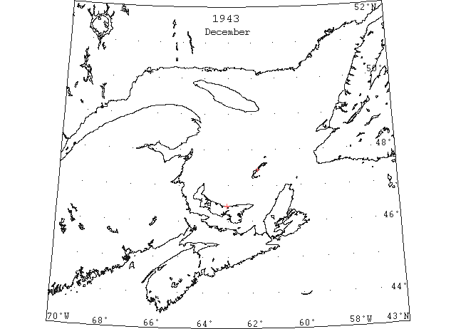
Dec Owing to the relatively high temperatures in the St. Lawrence and NF areas during the fall and winter of 1943-1944, the Gulf of St. Lawrence remained open much later than usual. Little ice was reported before early February whereas normally the entire gulf is considered unsafe for navigation after the 1st week of December. (IIP p45)
Dec 16 Chesapeake Bay: ice forming rapidly in Upper bay above Tolchester. (HB #2833 Dec 22, 1943)
Dec 27 Navigation to the Magdalenes will soon be closed. Already ice is forming around the Islands, in the bays and inlets; off the coast shore of P.E.I. ice and lolly extend about a mile offshore. (Pat 27 Dec p8 c3)
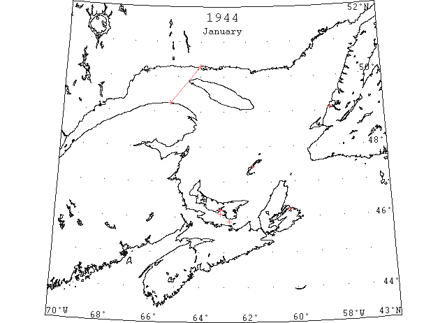
Jan Using Sydney Harbor as an index ice began to form in the bays and sheltered waters of Nova Scotia and Cape Breton Island around 12 Jan. Heavy ice was reported in Northumberland Strait on the 28th. Scattered patches of light ice only were present in Cabot Strait prior to the end of Jan. At that time, a vessel made the passage from Corner Brook to Sydney and St. George Bay was still open and easily accessible. (IIP 1946 p45)
Jan 3 Last departure of the season from Quebec. (WBB)
Jan 4 SS “Fairview” made last trip to Rocky Point on January 4th. (Pat 2 Jan 1945 p5 c3)
Jan 6 Drilling site in Hillsborough Bay 7 miles from Charlottetown, ice pans cause damage to crib work. (Pat 6 Jan p1 c4)
Jan 7 Winter air service to the Magdalene Islands is scheduled to begin on Friday (Jan. 7th)of this week. (Pat 6 Jan p8 c4)
Jan 9 Chesapeake Bay: ice conditions becoming severe. (HB #2836 Jan 12)
Jan 9 A plane from the RAF Station was forced down on the ice off Keppoch on Sunday Night (Jan 9th). (Pat 11 Jan p5 c3)
Jan 12 First ice racing on Charlottetown Harbour Wednesday (January 12th). (Pat 10 Jan p8 c5)
Jan 12-16 Light ice upper south arm Sydney Harbour. Cabot Strait, Sydney and Louisburg harbours and approaches clear. (IIP 1946 p63)
Jan 17-21 Heavy ice upper south arm and light ice lower south arm Sydney Harbour. Sydney and Louisburg approaches clear. (IIP 1946 p63)
Jan 20 Large pancake floes in Gulf of St. Lawrence near river mouth from Mingan to Cape Magdelen. 5/10 ice. (IIP 1946 p63)
Jan 22-26 Heavy ice upper south arm Sydney Harbour. (Note: This upper south arm remained frozen solid until April 12). (IIP 1946 p63)
Jan 27-31 Slob ice Sydney Harbour. (IIP 1946 p63)
Jan 28 Heavy ice in Northumberland Strait. Gut of Canso clear. Cabot Strait from Sydney to Port Aux Basques scattered ice only to this date. Sydney to Argentia clear. (IIP 1946 p63)
Jan 31 Slob ice Sydney Outer Harbour. (IIP 1946 p63)
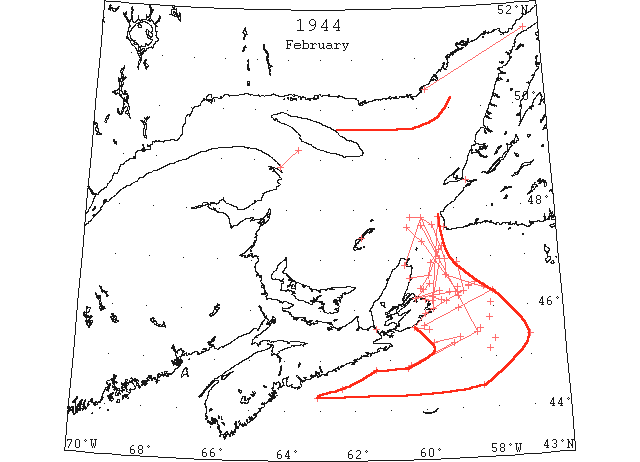
Feb This was the coldest month and the amount of ice increased rapidly. By 4 Feb., a belt of solid ice 30 miles wide extended westward along the south shore of Quebec to the vicinity of Anticosti Island. The center of the gulf was open, but heavy floes were sighted in the vicinity of Cape Ray. Ice began to move out of the gulf through the Cabot Strait and southward along the east coast of Cape Breton Island. This movement continued throughout the month, the out flowing ice became heavier and pushing farther south over the banks. The extreme limits of this ice together with ice formed locally on the banks during clod weather were reached on the 23rd of the month. On the 23rd Feb., ice reached positions of 44°26’N 58°23’W and 45°25’N 57°00’W. A 30-mile wide belt of locally formed ice extended along the south coast of Cape Breton Island was heavy pack sufficient to stop ice-protected vessels. Cakes up to 18 inches in thickness where not rafted, extended to the vicinity of 45°30’N 58°40’W. Outside this heavier core pans of clear young ice to 1 foot thick were encountered. (IIP 1946 p45)
Feb 2 Slob ice Sydney Outer Harbour. Heavy ice south arm. (IIP 1946 p63)
Feb 3 Light drift ice in Sydney outer harbour and to visibility limit in approaches. (IIP 1946 p63)
Feb 4 Belle Isle Strait solid cover. 8/10 cover heavy floe ice in 50°23’N 59°43’W. Solid ice extends 30 miles from S shore of Quebec. Drift ice around Magdalen Islands. Center of Gulf of St. Lawrence open. Light drift ice Sydney outer harbour and to visibility limit in approaches. Scattered small ice extending 10 to 20 miles off E shore Cape Breton Island. Light ice Louisburg inner harbour. At 47°38’N 59°20’W 8/10 heavy cover. (IIP 1946 p63)
Feb 7 Sydney outer harbour and approaches clear to 46°25’N 60°05’W. Slob thence to 46°40’N 59°50’W. Patches heavy pack thence to 46°55’N 59°45’W thence lighter with open stretches to 47°10’N 59°30’W and clear from 47°15’N 59°25’W to Port Aux Basques. Light slob ice Louisburg Harbour. (IIP 1946 p63)
Feb 9 Area 7/10 pack ice cover extends from Sydney Harbour 25 miles seaward and N along coast. (IIP 1946 p63)
Feb 9 Pack to 30 miles off E coast Cape Breton Island on course Sydney to Argentia. Cover heavy to N lighter to S. Limits not visible. (IIP 1946 p63)
Feb 9 Slob Louisburg Harbour. Approaches clear. (IIP 1946 p63)
Feb 9 Port Aux Basques clear to 47°10’N 59°30’W thence close pack very heavy in places to 46°40’N 59°50’W with slob extending to Cape Breton coast. (IIP 1946 p63)
Feb 10 Broken pack with some open water both sides course Sydney to 46°20’N 59°05’W. (IIP 1946 p63)
Feb 11 Open and close packed heavy ice along coast Sydney to Louisburg. Slob in Louisburg Harbour and approaches. Heavy ice to visibility limit from 10 miles SW of Louisburg to 15 miles SE of Guion Island. (IIP 1946 p63)
Feb 11 Slob from Louisburg to 46°09’N 59°20’W thence heavy remote ice to 46°20’N 58°50’W thence patches to 46°55’N 59°00’W thence open water to Port Aux Basques. (IIP 1946 p63)
Feb 14 Close packed drift ice Sydney Harbour and approaches. Slob Louisburg Harbour and approaches. Southern limit ice field 44°50’N 60°30’W. (IIP 1946 p63)
Feb 14 Eastern edge pack 6/10 cover 46°20’N 59°00’W to 47°21’N 60°00’W thence northwesterly. Closer cover heavy ice towards Cape Breton coast. Extended to visibility limit (25 miles) S. Many recemented pans and some new ice in the open leads. (IIP 1946 p63)
Feb 15 9/10 cover in Strait of Belle Isle. (IIP 1946 p63)
Feb 15 Slush vicinity Scatari Island thence heavy slabs to visibility limit N to NE. Slob Louisburg Harbour; heavy ice Sydney Harbour. (IIP 1946 p63)
Feb 16 Irregular edge broken pack from southern limit 44°50’N 60°30’W, 45°30’N 58°30’W, 46°15’N 59°00’W to 47°40’N 60°00’W. (IIP 1946 p63)
Feb 18 Eastern edge large field vicinity 46°25’N 58°15’W. 9/10 cover extends from coast Cape Breton Island between Cape North and Glace Bay to limits through 47°50’N 60°00’W, 47°00’N 59°30’W to 46°10’N 59°45’W. E of line joining 47°50’N 59°30’W and 46°10’N 59°45’W 7/10 cover between 46°15’N and 47°15’N. Light ice vicinity Scatari Island and Louisburg. No ice along line 44°30’N 61°00’W to 45°40’N 58°00’W. (IIP 1946 p63)
Feb 19 46°20’N 59°15’W 1/10 to 2/10 cover loose strings. 46°27’N 58°40’W 2/10 cover strings. 46°30’N 58°30’W 3/10 to 4/10 cover strings and patches with large cakes from Gulf of St. Lawrence present. 46°05’N 58°05’W only occasional small piece apparently eastern edge. (IIP 1946 p63)
Feb 19 Outer Sydney Harbour and approaches slush ice. (IIP 1946 p63)
Feb 19 Louisburg Harbour and approaches slob ice. (IIP 1946 p63)
Feb 21 Strip winter ice 8/10 cover 4 miles wide along N side St. George Bay vicinity Stephenville. (IIP 1946 p63)
Feb 22 Strait of Belle Isle 10/10 solid ice with small channel. Gulf of St. Lawrence mostly 10/10 cover with some small patches open water. Heavy pack 45°47’N 58°07’W. Approaches Sydney Harbour close packed drift to visibility limit. Light slob Louisburg Harbour and approaches. (IIP 1946 p63)
Feb 22 At 44°15’N 63°05’N western edge slush. Pancake ice at 44°26’N 62°23’W. Slob 6” thick in 7’ to 10’ diameter cakes at 44°48’N 61°24’W. (IIP 1946 p64)
Feb 22 Brash ice 2/10 to 9/10 cover 44°53’N 60°25’W to 45°18’N 59°10’W. (IIP 1946 p64)
Feb 23 Heavy pans at 45°20’N 59°45’W with young clear ice to 1’ thick thence to 45°26’N 59°00’W. Eastern edge at 45°22’N 58°00’W. Heaviest cakes 18” thick. (IIP 1946 p64)
Feb 23 Small patch drift ice vicinity Artimon Bank (45°10’N 58°10’W). Very scattered at 45°25’N 57°00’W. (IIP 1946 p64)
Feb 23 Eastern edge pack field at 44°26’N 58°23’W. Heavy scattered young ice all sides at 45°34’N 58°24’W. (IIP 1946 p64)
Feb 24 Outer limits pack 45°40’N 60°00’W, 46°00’N 59°00’W, 46°20’N 58°00’W, 46°40’N 59°20’W, 47°00’N 59°20’W, 47°40’N 59°40’W, 47°50’N 60°00’W, 47°50’N 60°20’W. Pack in Sydney and Louisburg approaches. (IIP 1946 p64)
Feb 25 Pack Cape Breton coast to approximately 46°25’N 58°40’W. (IIP 1946 p64)
Feb 25 Pack approaches to Sydney and Louisburg harbours. (IIP 1946 p64)
Feb 25 Heavy slob in Louisburg Harbour. (IIP 1946 p64)
Feb 26 Gut of Canso 7/10 cover pack. Fingers ice streaming out of bay to E. Some ice along S coast Cape Breton Island. Sydney Harbour and approaches 10/10 cover. (IIP 1946 p64)
Feb 26 Chesapeake Bay: ice conditions becoming severe at times. (HB #2842 Feb 26)
Feb 27 Eastern edge pack appears W of 46°25’N 59°00’W in poor visibility. Sydney approaches filled. (IIP 1946 p64)
Feb 29 Pack ice to limit of visibility limit in Sydney approaches. (IIP 1946 p64)
Feb 29 Heavy slob in approaches to Louisburg. (IIP 1946 p64)
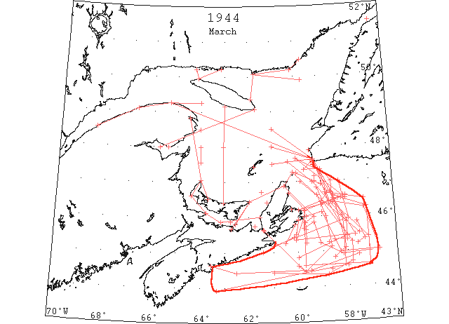
Mar The maximum southern extension of sea ice on the banks off Cape Breton Island and Nova Scotia was about the same as in Feb. Southwesterly winds at times pushed the ice to about 30 miles east of the Feb. limits. Heavy pack filled most of the central gulf throughout the month and a compact core of this ice extended through Cabot Strait to the vicinity of 46°10’N 59°00’W. The actual position changed depending time to time depending on the wind force and direction. Occasionally the heavy ice was tight against Scatari Island but never extended eastward as far as NF coast south of Cape St. George. At times leads may have opened through the core from west to east but these at best would have been of brief duration. Heavy ice did push at times almost to the southeast extremes of the limits shown for sea ice, but it was generally open near the outer edge. Heavy ice seldom was encountered west of 60°30’W, off the south coast of Cape Breton Island.
In early March… the SS “Kyle” [was] south of Scatari Island. It practically made no progress in the ice during the period 2 to 6 March, but had freed itself and was making good progress on the 7th.
During the last 10 days of Mar. the ice in the lower St. Lawrence River and in the gulf immediately south of Anticosti Island dissipated rapidly. By the end of the month the St. Lawrence River was mostly clear from Quebec to the river mouth and little ice remained in the gulf thence to 48°00’N 61°00’W. Except in sheltered bays the fast ice in the gulf west of the 64th meridian had broken loose and this area was clear. Heavy ice still blocked the southern part of the gulf in Northumberland Strait and from PEI and Cape Breton Island north past the Magdalene Islands. This heavy belt continued northeasterly across the gulf but was opening rapidly. (IIP 1946 p45-46)
Mar 1 Very heavy pack in all directions from Louisburg to 45°30’N 60°05’W thence heavy slob with open patches to 45°25’N 60°10’W and slush with occasional heavy pans to 45°00’N 61°25’W. Heavy pack in approaches Sydney and Louisburg Harbours. (IIP 1946 p64)
Mar 2 Close packed ice along E coast Cape Breton Island past visibility limit at 25 miles off shore. (IIP 1946 p64)
Mar 2-6 Ice protected vessel (SS “Kyle”) stuck in heavy pack ice vicinity Scatari Island from 2 – 6 Mar. (IIP 1946 p64)
Mar 4 Almost complete cover heavy ice from E coast Cape Breton Island past visibility limit at 10 miles off shore. Sydney approaches blocked. Louisburg approaches clear. (IIP 1946 p64)
Mar 5 Heavy ice S coast Cape Breton Island from E to Gut of Canso extending over 25 miles off shore. Solid ice in George Bay and Northumberland Strait from Pictou to East Point. Close packed off Sydney. Slob in Louisburg Harbour and approaches. (IIP 1946 p64)
Mar 6 Belle Isle Strait solid except for strip open water along NW side. (IIP 1946 p64)
Mar 6 Fairly solid from Cape Breton coast to 46°20’N 59°00’W thence scattered to 46°30’N 58°20’W. (IIP 1946 p64)
Mar 6 Outer edge main field St Paul Island through 46°36’N 59°10’W, 46°00’N 58°50’W, 45°08’N 58°39’W, 44°25’N 59°45’W thence southwesterly. Last position to Gut of Canso 2/10 to 7/10 cover. Pictou Island to East Point, PEI to Cape North solid ice. Cape North to St. Paul Island 9/10 cover. 4/10 to 9/10 heavy ice vicinity Scatarin Island. Slob Louisburg Harbour and approaches. (IIP 1946 p64)
Mar 6-7 Edge slush ice at 43°55’N 63°20’W thence slush, slob, and open patches to eastern edge at 44°35’N 58°00’W. Heavier pieces vicinity 44°30’N 58°40’W only ice causing reduction of vessel’s speed. (IIP 1946 p64)
Mar 7 Extreme limits pack ice through irregular limits 44°25’N 61°00’W, 44°20’N 58°50’W, 44°42’N 57°50’W, 45°15’N 57°48’W, 46°23’N 58°55’W and 46°50’N 59°10’W. Southern border light open ice with some slush and slob. Heavy pack to beach along E coast Cape Breton Island also over Misaine Bank. Some pieces heavy ice to over 300’ diameter. Tendency noted for heavy pieces to drift towards southeastern limits of the pack. New formed slob inshore W of Louisburg. Western limits beyond 61°00’W not visible. (IIP 1946 p64)
Mar 7 Heavy pack ice encountered from 44°53’N 57°34’W to 44°28’N 59°30’W thence pancake to 44°25’N 62°31’W thence slush to Halifax. (IIP 1946 p64)
Mar 9 Eastern edge pack 47°09’N 59°14’W. Heavy ice in vicinity 45°38’N 59°39’W. Light slob Louisburg Harbour with heavy close packed ice in approaches. (IIP 1946 p64)
Mar 11 Solid thick ice from Cape Breton coast to 46°25’N 59°00’W, 46°40’N 58°45’W, 46°55’N 59°00’W, 47°15’N 60°00’W. Lighter ice becoming broken and scattered to outer limits through points 45°10’N 61°00’W, 45°55’N 57°55’W, 47°00’N 58°15’W to 47°40’N 60°00’W. (IIP 1946 p64)
Mar 11 Pack Cape Breton coast to 46°30’N 58°05’W. Scattered near outer limits and close cover within 30 miles of beach. (IIP 1946 p64)
Mar 12 Edge heavy pack extends past Scatari Island to irregular limits through 45°20’N 60°05’W, 45°27’N 57°40’W, 46°28’N 58°29’W and NNW beyond visibility limit into Gulf. Scattered strings and patches up to 15 miles outside limits with slob westward past line Guion Island to 45°15’N 60°30’W (visibility limit). 3/10 to 4/10 cover outer edge increasing to0 9/10 to 10/10 in main body. Many cakes upwards from 20’ to 40’ diameter. (IIP 1946 p64)
Mar 12 Eastern edge pack from N to 47°35’N 60°20’W, 47°00’N 59°20’W, 45°50’N 58°00’W. Southern edge this heavy ice westward along 45°20’N. Light ice S this line. (IIP 1946 p64)
Mar 14 Eastern edge pack through 45°50’N 57°34’W, 45°20’N 57°18’W, 45°12’N 57°35’W. Light slob Louisburg Harbour with scattered drift in approaches. Close pack Sydney approaches. (IIP 1946 p64)
Mar 15 Pack Cape Breton Island to 46°35’N 58°00’W with some scattered pieces to eastward. (IIP 1946 p64)
Mar 19 Eastern edge pack 47°40’N 60°00’W through 46°30’N 58°00’W. Western edge Cape North clearing coast to 46°00’N 59°20’W, 45°50’N 59°40’W and S through 45°15’N. 10/10 cover vicinity St. Paul Island decreasing to 5/10 cover E of Scatari Island. Approaches to Sydney and Louisburg clear. (IIP 1946 p64)
Mar 19 Pack from off coast Cape Breton Island E to 46°35’N 58°05’W. Entire pack considerably broken with outer edges stringy. (IIP 1946 p64)
Mar 19 DOT aerial survey: Heavy close pack in Northumberland Strait. (CIS IC0941)
Mar 19 DOT aerial survey: From North Point eastward and northward to Gaspe Passage, 90% close pack well broken ice, no sheets. (CIS IC0772)
Mar 20 Eastern edge pack from beach vicinity Cape Ray to 47°20’N 59°40’W, 47°20’N 59°00’W, 47°00’N 58°35’W and southerly. (IIP 1946 p64)
Mar 20 DOT aerial survey: A large area of new ice from N coast of PEI, northward to the 48th parallel, then well broken, close pack to the S coast of Anticosti Island, and eastward and westward as far as can be seen. (CIS IC0734)
Mar 20 DOT aerial survey: Very open ice from North Point, east along N shore of PEI, as far as could be seen. (CIS IC0831)
Mar 20 DOT aerial survey: Large area of open water westward of a line from Perroquets Island to Cape Rabast. Open and close pack ice from there to Hunting Island, an area of open from there to Natashkwan Point, and then a narrow string of open water from there to Cape Whittle, then new ice from Cape Whittle, trending N and southeastward as far as can be seen. From N shore towards Anticosti, open and close pack ice. There are large areas of new ice recently formed. (CIS IC0856)
Mar 21 Strings and scattered floes Cape Breton coast to vicinity 46°30’N 58°10’W. (IIP 1946 p64)
Mar 21 Slush Sydney approaches; Louisburg approaches clear. (IIP 1946 p64)
Mar 22 Lower St. Lawrence River open and close packed with broken ice at Quebec. Gulf to Gut of Canso and Cabot Strait 7/10 to 10/10 cover. Outer limits Cape Ray to 46°21’N 58°41’W thence an undetermined distance SE thence 45°25’N 58°00’W thence 44°50’N 60°00’W. Clear from latter position through Gut of Canso. Scattered ice Sydney approaches. 7/10 to 9/10 pancake off mouth Louisburg Harbour. (IIP 1946 p64)
Mar 23 DOT aerial survey: In George Bay heavy close pack not navigable. (CIS IC0956)
Mar 23 DOT aerial survey: Some scattered ice in Strait of Canso to Hastings. (CIS IC0963)
Mar 23 DOT aerial survey: Large area of open water between East point, PEI and Cape Bear. (CIS IC0979)
Mar 23 DOT aerial survey: South coast of Newfoundland clear from 10 miles off Cape Ray east. (CIS IC1047)
Mar 23 DOT aerial survey: S coast of Cape Breton is clear, few strings in Chedabucto Bay and W of Canso, Louisburg clear. (CIS IC1081)
Mar 23 DOT aerial survey: Large area of open water on E coast of Magdalens. (CIS IC0817)
Mar 24 Light open ice Quebec to Father Point thence open water along N coast and open and close packed ice along S coast to 64°W. Close packed in gulf S of 48°30’N becoming very close packed from 61°W to Cape Ray. Outer limits pack Cape Ray to 46°37’N 58°32’W, 45°22’N 58°08’W, 44°36’N 58°08’W, 44°36’N 59°43’W to Scatari Island. Strings Chedabucto Bay and W of Canso. George Bay close packed. (IIP 1946 p65)
Mar 24 DOT aerial survey: S edge of ice runs to 46°37’N 58°32’W to 46°23’N 58°32’W to 45°22’N 57°08’W to 44°36’N 57°08’W to 44°36’N 59°43’W to Scatari. Within this area ice extends to Cape Breton coast but is open. (CIS IC0911)
Mar 24 DOT aerial survey: Cape des Rosiers to 61st meridian between 48°30’N and 49°00’N very open and soft S of 48°30’N to PEI and Bay of Chaleur and Bay of Chaleur close pack eastward from 61° to Cape Ray. (CIS IC0734)
Mar 25 River and Gulf approximately as on 24th except W shore of gulf beginning to open. Outer limits pack from 7 miles off Cape Ray to 46°00’N 58°10’W to 45°05’N 58°05’W thence 230° true. S coast Cape Breton Island clear. Sydney approaches clear but heavy ice still remains in harbour. (IIP 1946 p65)
Mar 25 DOT aerial survey: From 7 miles off Cape Ray the eastern edge of ice extends to 60 miles E and 150 miles SE and S of Scatari. (CIS IC0911)
Mar 25 DOT aerial survey: Ice in Bay of Chaleur loosening up. (CIS IC0926)
Mar 25 DOT aerial survey: Open water along S side of Northumberland Strait from Shippigan to Tormentine. Ice in vicinity of Pictou moving out, clear water from Pictou Island to Bay View shore. (CIS IC0941)
Mar 25 DOT aerial survey: Clear water from Gaspe westward to Maquereau. (CIS IC0752)
Mar 25 DOT aerial survey: Open water northward to Cape Anguille. (CIS IC0845)
Mar 26 Pack from 4 miles E coast Cape Breton Island to 46°30’N 58°30’W. (IIP 1946 p65)
Mar 26 DOT aerial survey: N side of Bay of Chaleur clear to New Carlisle. (CIS IC0926)
Mar 26 DOT aerial survey: St. Pauls, loose ice in all directions. (CIS IC1038)
Mar 26 DOT aerial survey: Magdalens, slob ice to westward. (CIS IC0799)
Mar 26 DOT aerial survey: Magdalens, loose ice eastward. (CIS IC0817)
Mar 27 Pack edge clear NE coast of Cape Breton Island 4 to 10 miles thence extends from 4 miles off Scatari Island to 46°08’N 59°00’W, 44°58’N 58°18’W to 45°00’N 56°43’W thence irregularly to 46°13’N 57°16’W, 46°25’N 58°40’W 47°15’N 59°00’W thence northwesterly into gulf clearing Cape Ray by estimated 8 to 10 miles. Scattered strings and patches to 15 miles N of pack between 57°15’W and 58°50’W. Southern and eastern edge quite widely scattered with less than 3/10 coverage near border. Very heavy along line from 47°00’N 59°50’W to 45°30’N 57°30’W. (IIP 1946 p65)
Mar 27 Quebec to Father Point light broken ice thence mostly close to 64°W and loosening up across gulf to Cape Ray. Close packed in George Bay. Sydney S and W arms still frozen with remainder of harbour and approaches clear. (IIP 1946 p65)
Mar 27 DOT aerial survey: From Cape des Rosiers steamer track to Cape Ray, ice loosening up. No ice at Heath point, loose around Magdalens. (CIS IC0734)
Mar 27 DOT aerial survey: Gaspe Bay clear to Douglastown. (CIS IC0763)
Mar 29 Open water to 25 miles off Cape Breton coast at 46°10’N thence pack, heavy in places, to 46°35’N 58°00’W. (IIP 1946 p65)
Mar 29 Mostly clear water from Quebec to 48°00’N 61°00’W in gulf. Gulf mostly open W of 64°00’W. Heavy ice in George Bay blocks Gut of Canso. From 48°00’N 61°00’W to Cape Ray open and close pack becoming very open vicinity Cape Ray. Outer edge thence to 46°35’N 58°30’W, 46°15’N 57°10’W, 44°57’N 57°07’W, 44°55’N 58°10’W, 45°15’N 59°05’W, 45°50’N 59°20’W, 45°40’N 59°45’W to Scatari Island [this ice moving rapidly southeastward (CIS IC0911)]. Western edge thence to 3 miles off Flint Island northward to Ingonish. Approaches Sydney and Louisburg clear. (IIP 1946 p65)
Mar 29 DOT aerial survey: Narrow strip of ice along S coast of PEI from North Point to vicinity of Tormentine. Close pack ice midway in strait from Tormentine for 30 miles eastward, then close packed eastward to Cape Breton shore. (CIS IC0941)
Mar 29 DOT aerial survey: Within the following area scattered strings from entrance to Bay of Chaleur along 48th parallel, to Heath Point, with ice moving rapidly eastward. (CIS IC0752)
Mar 29 DOT aerial survey: Open water from North Point, northward for 30 miles, eastward as far as can be seen, and westward to New Brunswick shore. From there to the 48th parallel, patches and strings. (CIS IC0803)
Mar 29 DOT aerial survey: From 61st meridian between 48th and 49th parallels to Cape Ray open and close pack ice, very open in vicinity of Cape Ray. (CIS IC0845)
Mar 30 Eastern edge pack extends southeastward through 47°00’N 59°15’W. E coast Cape Breton Island blocked N of 46°10’N. (IIP 1946 p65)
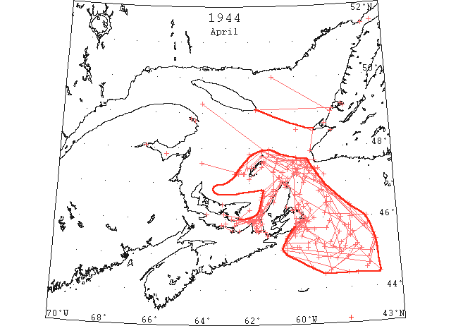
Apr The normal steamer track across the gulf from Cape Ray passing north of Bird Rocks thence to Cape des Rosiers and up the river to Quebec was navigable on 4 Apr., and to Montreal on the 20th. In 1942 this route opened on the 4th, but in 1943 was closed until the 30th. In most years it can be expected to open about the middle of the month. By 11 Apr all ice of consequence north of this steamer track had receded to the north of a line from the NF coast near 49°00’N 58°30’W to a position of 50°00’N 61°00’W. Heavy ice persisted in the southern part of the gulf extending from the northwest and west coasts of Cape Breton Island to PEI until late in the month. It was not until the 26th that this ice sufficiently dispersed to permit passage of vessels to the gulf over the Gut of Canso- George Bay route. This route had opened on 24 Apr. in 1943. By the end of Apr. the gulf was practically clear except for the northeastern portion in the approaches to the Strait of Belle Isle.
The opening of the gulf along the track from Cape Ray to the mouth of the St. Lawrence River with the ice subsequently receding both to the north and south of that route appears to be a normal occurrence.
In Apr., as contrasted to Feb. and Mar., no ice was reported along the south coast of Nova Scotia westward from Cape Canso. (approx. 61st meridian). The ice reported in that area the preceding months was mostly, if not all, formed on the spot during periods of cold weather.
In the spring when the ice is breaking up, that encountered near the fringes of the field is not the light ice frequently met at the edge during times of formation. The ice on the lee side of the field is at times open and rotten, but is the remnants of heavy pack and may be both compact and heavy close where first encountered. More often than not a heavy close packed border will be found along the windward side of the field. An area of heavy close packed ice 15 to 20 miles wide was reported between 44°59’N 58°30’W and 45°10’N 58°10’W, on the 27th. Heavy ice had persisted in this general vicinity at the southern edge of the pack throughout most of the week before it disappeared. (IIP 1946 p46-48)
Apr 1 Close packed drift ice in Sydney Harbour and approaches Louisburg and Sydney Harbours. (IIP 1946 p65)
Apr 2 Mostly open water from 48°00’N 61°00’W up river to Quebec. Close packed ice in Strait of Canso and George Bay. Pack along E coast Cape Breton Island to Scatari Island thence western edge clears coast to 45°26’N 60°30’W thence 44°58’N 60°30’W with southern edge easterly through 44°25’N 58°05’W. (IIP 1946 p65)
Apr 3 Pack extends from E coast Cape Breton Island to 46°25’N 58°40’W. (IIP 1946 p65)
Apr 3 Eastern edge heavy ice through 46°00’N 57°55’W and 45°30’N 57°55’W. (IIP 1946 p65)
Apr 3 Heavy close packed Sydney and approaches. Drift ice 3 miles off Louisburg. George Bay packed. (IIP 1946 p65)
Apr 3 DOT aerial survey: Western edge of ice field extends from 10 miles S of St. Esprit to 44°58’N 60°30’W to 44°25’N 58°05’W and eastward. This ice field is very heavy and close packed. (CIS IC0911)
Apr 3 DOT aerial survey: Strait of Canso clear with close packed ice in George Bay extending westward of Pictou Island. (CIS IC0963)
Apr 3 DOT aerial survey: Ice has moved off S coast of Cape Breton and extends from Scatari to 10 miles off St. Esprit with a narrow string running southward from Union Island to edge of ice field and scattered pans. (CIS IC1081)
Apr 4 Outer edge pack through 47°42’N 60°02’W, 45°45’N 57°20’W, 45°20’N 57°00’W, 45°00’N 57°10’W, 45°10’N 59°00’W, 45°25’N 59°15’W, 45°17’N 59°40’W, 45°17’N 60°33’W, 45°40’N 60°00’W to Scatari with some open water along coast to N. Ice vicinity St. Paul Island heavy with some recemented floes greater than ½ miles in diameter. Only occasional strings in gulf south 48°30’N, E of 60°W. Pancake ice with large areas open water in St. George Bay inside line Cape St. George to Cape Anguille. (IIP 1946 p65)
Apr 4 Quebec to Red Island some light broken ice thence mostly clear to Cape des Rosiers with steamer track thence to Bird Rocks to Cape Ray navigable and mostly clear. Northern edge ice in south part of gulf from 47°25’N 59°40’W to Bird Rocks thence 47°55’N 61°30’W, 47°50’N 62°00’W, 47°16’N 62°13’W thence westward. Heavy ice in George Bay and Northumberland Strait to 63°W thence open water to westward. Occasional strings Cape Ray to 60°W. Approaches Sydney Harbour blocked by close packed ice extending along E coast Cape Breton Island. (IIP 1946 p65)
Apr 4 DOT aerial survey: Heavy ice in Northumberland Strait from Hillsborough Bay westward. Some open water along S side of Northumberland Strait from Merigomish westward. (CIS IC0941)
Apr 4 DOT aerial survey: Some open water along George Bay, from Cape George to Antigonish Bay. (CIS IC0956)
Apr 4 DOT aerial survey: From Cape des Rosiers eastward over steamer track to Bird Rocks and Cape Ray mostly clear and this area is navigable, occasional strings between Cape Ray and 60th meridian. (CIS IC0734)
Apr 4 DOT aerial survey: Northern edge of ice extends to Bird Rocks to 8 miles N of Brion Island to 20 miles W of Grindstone to Deadmans Island, then trending westward. On steamer track from Cape Ray to Gaspe Bay, occasional strings to the 60th meridian. No ice sighted westward on the track. (CIS IC0770)
Apr 4 DOT aerial survey: Open water along N coast of PEI from 15 to 30 miles wide from East Point westward. (CIS IC0831)
Apr 5 DOT aerial survey: N side of Bay of Chaleur and approaches clear to westward of New Carlisle. (CIS IC0926)
Apr 5 DOT aerial survey: Western approaches of Northumberland Strait practically clear from Miscou to Tormentine with open water along S coast of PEI. Close packed ice in George Bay extending westward of Pictou Island, this area not navigable. (CIS IC0941_2)
Apr 6 River and gulf navigable Cape Ray to Quebec with practically no ice remaining on steamer route. Heavy pack from Cape Breton Island to outer limits 47°35’N 64°00’W, 47°16’N 62°13’W, 47°50’N 62°00’W, 47°57’N 61°09’W, 47°25’N 59°40’W, 45°20’N 56°55’W, 44°49’N 57°15’W, 45°10’N 60°40’W thence clearing coast to Scatari Island. George Bay and Northumberland Strait blocked to 63°W. (IIP 1946 p65)
Apr 6 DOT aerial survey: Gaspe Bay harbour and basin still frozen. (CIS IC0763)
Apr 7 Outer edge pack through approximate limits 46°25’N 58°53’W, 45°05’N 57°30’W, 44°24’N 59°00’W, 44°35’N 59°30’W, 45°10’N 60°00’W. Shore lead 5 or more miles wide along Cape Breton coast from Louisburg west. (IIP 1946 p65)
Apr 7 Pack moving off E coast Cape Breton Island. Inner edge 5 miles off Louisburg. Gut of Canso clear with ice in George Bay opening up. Loose ice all bearings from Magdalen Islands. (IIP 1946 p65)
Apr 7 Pack edge from 5 miles off Louisburg to 45°25’N 60°30’W to 45°10’N 60°20’W thence easterly. 6/10 to 10/10 cover in body of pack from St. Paul Island to 45°30’N.
Apr 7 DOT aerial survey: From 18 miles SW of Cape Ray ice extends in a SE direction to 45°20’N 56°55’W to 44°40’N 57°15’W thence irregularly to 15 miles SE of Cape Canso to 8 miles S of St. Esprit to vicinity of Scatari. (CIS IC0911-IC0911_2)
Apr 7 DOT aerial survey: Heavy close packed ice in George Bay and up W coast of Cape Breton and westward in Northumberland Strait to Hillsborough Bay. From Hillsborough Bay westward through Northumberland Strait and northward along New Brunswick coast to Miscou practically clear except for a few strings in vicinity of Tormentine. (CIS IC0941_2)
Apr 7 DOT aerial survey: Route through Strait of Canso via East Point and Northumberland Strait not navigable. (CIS IC0963)
Apr 7 DOT aerial survey: Gaspe Bay harbour and basin frozen but approaches clear to 3 cables inside Sandy Beach bight. (CIS IC0763)
Apr 8 Gulf west of 62°W between 47°N and Anticosti Island practically clear. Northern edge ice in southern part of gulf from Brion Island to 47°38’N 59°50’W thence outer edge southeasterly. Western edge from 7 miles off Sydney Harbour past Scatari Island and southwesterly. Heavy ice along N coast Cape Breton Island extending through George Bay into Northumberland Strait. (IIP 1946 p65)
Apr 8 DOT aerial survey: Open water for 15 miles off Cheticamp to 5 miles off Port Hood to 5 miles N of Pictou Island to South Point, PEI. (CIS IC0998)
Apr 8 DOT aerial survey: Large area in gulf N of 47th parallel and westward of 62nd meridian now practically clear of ice. (CIS IC0752)
Apr 9 Patch 10/10 at 43°07’N 58°06’W; 2/10 brash 44°40’N 57°12’W, 44°33’N 57°20’W. (IIP 1946 p65)
Apr 10 Pack in N gulf now receded N of line from Heath Point to Cape St. George, Nfld. A few scattered strings on steamer track from Cape Ray N of Bird Rocks to Gaspe. Open water around Magdalen Islands. George Bay blocked. 10 mile wide strip close packed ice along N coast of Cape Breton Island broadening along E coast. Upper south arm Sydney Harbour still frozen with remainder of harbour and approaches clear. E edge of pack 18 miles off Cape Ray extending southeasterly. (IIP 1946 p65)
Apr 10 DOT aerial survey: Bay of Chaleur clear to New Carlisle with some ice along S shore with Nipisigit full. (CIS IC0926)
Apr 10 DOT aerial survey: Gaspe harbour and basin unchanged. (CIS IC0763)
Apr 10 DOT aerial survey: From Gaspe passage over usual steamer track N of Bird Rocks to Cape Ray a few scattered strings. (CIS IC0770)
Apr 10 DOT aerial survey: No ice sighted S of a line from Heath Point to Cape St. George to the northern edge of the ice field extending from 6 miles W of Magdalens to Brion Island to 15 miles NW of St. Pauls to 20 miles N of St. Pauls to 5 miles NE of St. Pauls to 20 miles SE of St. Pauls to 15 miles SE of Cape Ray. (CIS IC0845)
Apr 11 Pack in NE part of gulf has receded to the N of a line from 50°00’N 61°00’W to Nfld coast near 49°00’N 58°30’W. No ice along route from Mingan to Stephenville. Some light ice inshore Port Au Port Bay, also near Sandy Point, St. George Bay. (IIP 1946 p65)
Apr 11 Western edge pack in the southern part of the gulf from 46°00’N 62°20’W to 46°07’N 61°40’W, 46°47’N 61°26’W, 47°10’N 60°45’W, 47°08’N 60°24’W, 47°38’N 61°22’W. Northumberland Strait west of 63°W clear. Northern edge through 47°25’N 62°05’W to Brion Island to 47°23’N 60°25’W, 47°34’N 60°09’W, 47°00’N 59°45’W, 47°20’N 59°30’W thence southeasterly. (IIP 1946 p66)
Apr 11 Eastern edge pack from 47°25’N 60°10’W to 47°05’N 59°20’W, 46°20’N 57°55’W, 46°00’N 57°50’W. SE limits not defined. Narrow strip open water along E coast Cape Breton Island past Scatari Island. SW corner pack near 45°10’N 59°40’W. (IIP 1946 p66)
Apr 11 DOT aerial survey: Westward of a line from Hillsborough Bay to Amet Sound in Northumberland Strait, clear water. (CIS IC0941_2)
Apr 11 DOT aerial survey: Close packed ice in George Bay. (CIS IC0956)
Apr 11 DOT aerial survey: Strait of Canso clear, some drift ice northward from Melford. Small opening N entrance of strait; unbroken sheet about 1 miles in width extends across the N entrance of Strait of Canso from Pomquet harbour to Cape Breton shore. (CIS IC0963)
Apr 11 DOT aerial survey: Western edge of this ice field as follows: from 5 miles off Cape Bear, PEI to 8 miles W of Port Hood, thence irregularly to 10 miles off Sea Wolf to 20 miles off Cheticamp to 10 miles NW of Cape St. Lawrence to 5 miles N of Cape North to East point, Magdalens. (CIS IC0991_2)
Apr 12 Extreme limits pack including strings and patches from Cape Breton through 45°43’W 59°48’W, 45°25’N 59°15’W, 45°16’N 59°22’W, 44°52’N 59°15’W, 44°52’N 58°46’W, 45°10’N 57°45’W, 44°25’N 56°50’W, 45°30’N 57°00’W, 46°23’N 58°00’W, 46°47’N 59°00’W, 47°14’N 60°02’W, thence westerly and northerly towards Bird Rocks. Density of coverage 2/10 to 10/10 with individual cakes to over a mile long. Core of heavier ice broken in places to near SE and SW extremes of pack. (IIP 1946 p66)
Apr 12 Sydney and Louisburg Harbours and immediate approaches clear, with pack visible offshore from Sydney. (IIP 1946 p66)
Apr 12 DOT aerial survey: Edge of ice field off E and S coast of Cape Breton as follows: 47°10’N 59°40’W to 47°00’N 59°05’W to 45°00’N 58°20’W to 45°40’N 59°40’W to 46°15’N 60°00’W. (CIS IC0911_2)
Apr 12 DOT aerial survey: Louisburg harbour and approaches clear, close packed ice 6 miles off to limits of visibility. (CIS IC1081)
Apr 13 DOT aerial survey: Route through Strait of Canso to Pictou not navigable, probably continuing for some time. (CIS IC0963)
Apr 13 DOT aerial survey: Ice has moved inshore on S coast. Louisburg harbour clear with close packed ice in approaches. (CIS IC1081)
Apr 14 River and gulf navigable to Quebec via Cape Ray, also via Strait of Canso, George Bay and Northumberland Strait. Southern limits pack in eastern part of gulf from South Point, PEI, clearing Cape George to Cape Breton coast near 45°52’N 61°30’W. Western edge 46°27’N 61°61[? 01’?]W to 47°18’N 60°35’W to 47°35’N 61°25’W. Northern edge from 6 miles off Amherst Island to 20 miles off Brion Island to Bird Rocks to 11 miles NE of St. Paul Island to 10 miles S Port Aux Basques thence trending SE. Open water along E coast Cape Breton Island from Cape Smoke (46°37’N 60°21’W) past Scatari Island. Narrow strip ice along S coast past 60°W with some scattered in Louisburg Harbour. (IIP 1946 p66)
Apr 14 DOT aerial survey: Route via Strait of Canso, George Bay, to Pictou and westward through Northumberland Strait now navigable. (CIS IC0941_2)
Apr 14 DOT aerial survey: Ice moving northward rapidly in George Bay with southern edge extending westward from Judique to 10 miles SE of Cape George to 6 miles NE of Cape George to South Point, PEI. Route via Strait of Canso, George Bay, to Pictou now navigable. (CIS IC0956)
Apr 14 DOT aerial survey: Route via Strait of Canso, George Bay, to Pictou and westward through Northumberland Strait now navigable. (CIS IC0963_2)
Apr 14 DOT aerial survey: Ice moving off E coast of Cape Breton with open water to 7 miles off Cape North to Aspy Bay, then loose ice along coast to Cape Smoky then open water to vicinity of Scatari approximately 6 miles wide off Flat Point. (CIS IC1019_2)
Apr 14 DOT aerial survey: Some scattered ice in Louisburg harbour with narrow strip along coast to Gabarus Bay. No ice sighted off S coast of Cape Breton. (CIS IC1081)
Apr 14 DOT aerial survey: Large area in western part of Gulf west of 62nd meridian clear; from 6 miles off Amherst Island to 20 miles off Brion Island to Bird Rocks to 11 miles NE of St. Pauls to 10 miles S of Port au Basque where edge of ice trends SE. (CIS IC0734-IC0734_2)
Apr 14 DOT aerial survey: Gaspe Bay harbour and approaches broken E of a line of bearing 323° from Cape Haldimand. (CIS IC0763)
Apr 15 Ice field along W coast Cape Breton Island N of 46°N. Otherwise river and gulf practically clear W of 61°W. Routes open through Gut of Canso via both sides of PEI. Louisburg Harbour full. Sydney Harbour clear. (IIP 1946 p66)
Apr 15 DOT aerial survey: George Bay western part clear, eastern part close packed ice extending northward along Cape Breton coast. (CIS IC0956)
Apr 15 DOT aerial survey: Some light drift ice in Strait of Canso. (CIS IC0963_2)
Apr 15 DOT aerial survey: Route via East Point, PEI now navigable by passing W of ice field off W coast of Cape Breton. (CIS IC0991_2)
Apr 15 DOT aerial survey: Louisburg harbour full but approaches and westward along coast clear. (CIS IC1081)
Apr 15 DOT aerial survey: River and Gulf of St. Lawrence now practically clear to 61st meridian except for ice field on W coast of Cape Breton from vicinity of Port Hood Island northward. (CIS IC0734_2)
Apr 16 DOT aerial survey: St. Pauls, ice visible 5 miles eastward, all other directions clear. (CIS IC1038)
Apr 16 DOT aerial survey: Magdalen Islands clear. (CIS IC0817)
Apr 17 Only ice of consequence in southern part is that surrounding Cape Breton Island through outer limits 45°40’N 61°40’W, 45°55’N 61°47’W, 46°08’N 61°35’W, 46°33’N 61°30’W, 46°50’N 61°00’W, 47°20’N 61°00’W, 47°37’N 60°50’W, 47°37’N 59°40’W, 47°23’N 59°15’W thence in a southeasterly direction to over 60 miles E and SE of Scatari. Narrow strip open water inshore along W coast Cape Breton Island to 46°50’N. Open water along E coast from 15 miles off Cape Smoke to S. Scattered ice Louisburg Harbour and vicinity Guion Island. Gut of Canso clear but northern exit into George Bay blocked. (IIP 1946 p66)
Apr 17 DOT aerial survey: Ice has moved southward in George Bay and route via Strait of Canso through George Bay is now blocked. (CIS IC0956)
Apr 17 DOT aerial survey: Strait of Canso clear to Melford with scattered ice northward. Ice has moved southward in George Bay and route via Strait of Canso through George Bay now blocked. Narrow strip of water 2 to 4 miles wide along W coast of Cape Breton from N entrance to Strait of Canso to 5 miles S of Cape St. Lawrence. (CIS IC0963_2)
Apr 17 DOT aerial survey: Narrow strip of water 2 to 4 miles wide along W coast of Cape Breton from N entrance to Strait of Canso to 5 miles S of Cape St. Lawrence, (CIS IC0998)
Apr 17 DOT aerial survey: Open water from St. Anns Bay to 15 miles E of Cape Smoky and southward to Flint Island. (CIS IC1019_2)
Apr 17 DOT aerial survey: River and Gulf of St. Lawrence now practically clear to 61st meridian and except for ice in NE part of Gulf eastward of a line from Anticosti Island to Bay of Islands, Nfld. Only ice of consequence is that surrounding island of Cape Breton within following limits: from Tracadie harbour in George Bay to 5 miles off Cape George to 5 miles off Mabou to 15 miles NW of Sea Wolf Island to 4 miles off White Cape to 23 miles NW of Cape St. Lawrence to 18 miles SE of Bird Rocks to 14 miles W of Cape Ray to 14 miles S of Cape Ray thence in a southeasterly direction to approximately 60 miles E and SE of Scatari. This ice is very open W of a line from Scatari to St. Pauls. (CIS IC0734_2)
Apr 18 DOT aerial survey: Ice in George Bay loosening up. (CIS IC0956_2)
Apr 18 DOT aerial survey: Louisburg scattered drift ice in harbour and approaches. (CIS IC1081_2)
Apr 18 DOT aerial survey: Route to Quebec via Cape Ray, Bird Rocks, Fame Point, navigable. (CIS IC0734_3)
Apr 18 DOT aerial survey: Gaspe Bay area open water inside Sandy Point spit gradually widening. (CIS IC0763)
Apr 19 DOT aerial survey: Open ice along S coast of Cape Breton from Scatari to Union Island to 10 miles S of St. Esprit with southern edge from 10 miles S of St. Esprit to 20 miles S of Scatari and eastward as far as can be seen. (CIS IC0911_2)
Apr 19 DOT aerial survey: Ice in George Bay very open from Harbour Boucher to Henry Island. (CIS IC0956_2)
Apr 19 DOT aerial survey: Ice is very open for a distance of 30 miles off E coast of Cape Breton. (CIS IC1019_2)
Apr 19 DOT aerial survey: Open ice along S coast of Cape Breton from Scatari to Union Island to 10 miles S of St. Esprit with southern edge from 10 miles S of St. Esprit to 20 miles S of Scatari. (CIS IC1081_2)
Apr 19 First arrival of season at Quebec. (WBB)
Apr 20 Limits broken pack and patches from 1/10 to 10/10 cover with much open water from gulf to 46°23’N 60°00’W, 46°30’N 59°50’W, 46°20’N 59°48’W, 46°00’N 59°32’W, 45°45’N 59°55’W, 45°42’N 58°53’W, 45°54’N 58°45’W, 45°34’N 58°22’W, 45°10’N 58°40’W, 45°07’N 58°25’W, 45°17’N 58°20’W, 45°27’N 57°56’W, 45°47’N 57°12’W, 46°00’N 57°15’W, 46°07’N 58°56’W, 46°20’N 58°50’W. and northerly towards gulf. The field opening up and dissipating rapidly. Ice protected vessels could cross fields at many places, and escort type vessels at a few points N of 46°N. Some 10/10 heavy ice persists at southern extremity of pack. (IIP 1946 p66)
Apr 20 Gulf and river ice navigable to Montreal via Cape Ray, Bird Rocks and Fame Point. Bai Chaleur navigable. Heavy ice remains in NE gulf blocking Strait of Belle Isle. Gut of Canso route blocked by ice in George Bay. Western edge ice off Cape Breton W coast from Cape George to 4 miles off Port Hood thence strip 2 to 4 miles wide to Cape St. Lawrence. Scattered ice vicinity St. Paul Island with eastern edge trending SE through 47°15’N 59°10’W. Sydney and Louisburg Harbours and approaches clear. (IIP 1946 p66)
Apr 20 DOT aerial survey: Route via Northumberland Strait clear with some scattered drift ice on S side between Pictou Island and Amet Sound and also via East Point. (CIS IC0941_3)
Apr 20 DOT aerial survey: Strait of Canso and George Bay not considered navigable today. Scattered ice in Strait of Canso in vicinity of Eddy Point and Melford with considerable ice at Beacon and northward in George Bay. (CIS IC0963_2)
Apr 20 DOT aerial survey: Western edge of ice off W coast of Cape Breton as follows: from Pomquet harbour to Cape George to 13 miles N of Cape George to 4 miles off Port Hood with a strip 2 to 4 miles in width northward to vicinity of Cape St. Lawrence. (CIS IC0998)
Apr 20 DOT aerial survey: Scattered ice around St. Pauls. (CIS IC1038)
Apr 20 DOT aerial survey: Louisburg harbour and approaches clear. (CIS IC1081_2)
Apr 20 DOT aerial survey: Heavy ice in NE part of gulf with Point Amour heavy close packed Arctic ice. (CIS IC0734_3)
Apr 21 DOT aerial survey: Louisburg harbour and approaches clear, drift ice visible 9 miles seaward. (CIS IC1081_2)
Apr 21 Georgetown – the ferry boat Montague made its first trip on April 21st, the harbour is now clear of ice. (Pat 27 Apr p8 c5)
Apr 22 Considerable ice in Chedabucto Bay and Gut of Canso. Close packed ice in George Bay with western edge 45°55’N 62°00’W to 46°00’N 61°55’W, 46°00’N 61°40’W thence narrow strip along N coast Cape Breton Island to Cape North. Narrow strip running 40 miles NE to SW centers at St. Paul Island. Northern edge ice on E coast Cape Breton Island from Aspy Bay to 46°40’N 59°55’W, 47°34’N 59°37’W thence southeasterly. Western edge clears coast from 45°35’N 60°15’W past Scatari Island to Aspy Bay. Field mostly open with large area open water. (IIP 1946 p66)
Apr 22 DOT aerial survey: Considerable ice in Chedabucto Bay. On E coast of Cape Breton northern edge of ice from Aspy Bay to 30 miles SE of Cape North to 18 miles SW of Port au Basques, then in a SE direction to approximately 50 miles E of Scatari. This ice is very open with large area of open water. Open water along E coast 3 to 4 miles in width from Aspy Bay to Flint Island. (CIS IC1019_2)
Apr 22 DOT aerial survey: Very narrow string (of ice) from 20 miles NW of St. Pauls through St. Pauls to 20 miles SE. (CIS IC1038)
Apr 22 DOT aerial survey: Louisburg harbour and approaches clear, drift ice visible 4 to 8 miles off shore from Port Nova to SW of Louisburg. (CIS IC1081_2)
Apr 24 Field enclosed by positions: 46°24’N 59°38’W, 46°13’N 59°31’W, 45°30’N 59°50’W, 45°15’N 59°00’W, 44°30’N 58°46’W, 44°52’N 58°05’W, 45°14’N 57°40’W, 45°35’N 57°50’W, 45°45’N 58°08’W, and 46°46’N 59°09’W. Except for area closely packed ice near southern extreme these limits ice mostly broken and scattered. Only a few scattered patches N these limits to Cape North and St. Paul Island. St. George Bay entirely fee of ice. Bay of Islands clear except for fast ice in North Arm and Goose Arm. Southern edge pack beyond visible limit at 49°20’N. (IIP 1946 p66)
Apr 24 Gut of Canso blocked by ice in George Bay. Narrow strip 1 to 4 miles wide extends to W coast Cape Breton Island to Cape North. Open ice vicinity Scatari Island with a few scattered strings and patches along S coast to 60°10’W. Entire E coast Cape Breton Island navigable between beach and pack. (IIP 1946 p66)
Apr 24 DOT aerial survey: George Bay packed on western side with open ice on eastern side to Henry Island with western edge as follows: from 4 miles W of Cape George to 10 miles NW to 1 mile off Henry Island, then a narrow strip 1 to 4 miles wide extending northward along coast to Cape North. (CIS IC0956_2)
Apr 24 DOT aerial survey: Considerable ice passing through Strait of Canso. (CIS IC0963_2)
Apr 24 DOT aerial survey: A narrow strip 1 to 4 miles wide extending northward along coast to Cape North. (CIS IC0998)
Apr 24 DOT aerial survey: Occasional small strings between Cape North and St. Pauls. (CIS IC1038)
Apr 24 DOT aerial survey: Open ice in vicinity of Scatari with some scattered strings and patches off and along S coast to Forchu. (CIS IC1081_2)
Apr 24 DOT aerial survey: Ice surrounding island of Cape Breton loosening up. (CIS IC0734_3)
Apr 26 Remnant of pack ice in George Bay navigable with route through Gut of Canso open. (IIP 1946 p66)
Apr 27 Pack remnants in George Bay extend from 5 miles W of Cape George to Cape Bear to 46°15’N 62°00’W thence very scattered along W coast Cape Breton Island. East coast clear except for small patches. Field off S coast bounded by 46°40’N 60°08’W, 45°45’N 58°00’W, 45°10’N 58°10’W, 44°49’N 58°30’W. Mostly strings W of 59th meridian and strings and patches E thereof, except for heavy close packed area 15 to 20 miles wide from 45°10’N 58°10’W to 44°49’N 58°30’W. Little ice now left in Gulf except for NE portion in the Strait of Belle Isle. (IIP 1946 p66)
Apr 27 DOT aerial survey: No ice sighted N of 45°50’N. Off S coast of Cape Breton isolated and scattered strings and patches within the following area: from 5 miles S of Union Island to 45°45’N 58°00’W to Artimon Bank to 44°49’N 58°30’W to Union Island. West of 59th meridian mostly strings and patches except for a heavy field close packed with some very heavy pieces dangerous to navigation from Artimon Bank about 15 to 20 miles wide extending to SW edge of ice limit. (CIS IC0911_2)
Apr 27 DOT aerial survey: Bay of Chaleur navigable to Dalhousie. (CIS IC0926)
Apr 27 DOT aerial survey: Ice in George Bay is within following limits: from 5 miles W of Cape George to Cape Bear to 9 miles S of Henry Island to Fouquet harbour. Within these lines, open and close packed ice. Some scattered ice on E side of George Bay to Henry Island. (CIS IC0956_2)
Apr 27 DOT aerial survey: Navigation now possible through Strait of Canso and along W coast of Cape Breton to Henry Island but route via George Bay liable to close again with westerly wind. (CIS IC0963_2)
Apr 27 DOT aerial survey: W coast of Cape Breton clear with exception of small patch in Aspy Bay and head of St. Ann’s Bay. (CIS IC0998&IC1019_2)
Apr 27 DOT aerial survey: Navigation now possible along S and E coast of Cape Breton and through Strait of Canso. (CIS IC1016_2)
Apr 27 DOT aerial survey: Navigation now possible along S and E coasts of Cape Breton and through the Strait of Canso. (CIS IC1081_3)
Apr 27 DOT aerial survey: Only ice of consequence left with exception of ice in NE portion of gulf and Strait of Belle Isle is that in George Bay and off S coast of Cape Breton. (CIS IC0734_3)
Apr 27 Covehead – The Gulf is fairly clear of ice along the north side. There is still much ice in Covehead Bay. (Pat 27 Apr p8 c6)
Apr 28 No ice sighted enroute Sydney to Argentia. (IIP 1946 p66)
Apr 28 According to all reports … there is no ice on the North Shore to impede fishermen. (Pat 28 Apr p5 c3)
Apr 29 Except for NE portion of gulf remaining ice of only local importance. George Bay clear to visibility limit. (IIP 1946 p66)
Apr 30 Banks S and SE of Cape Breton now clear of ice. (IIP 1946 p66)
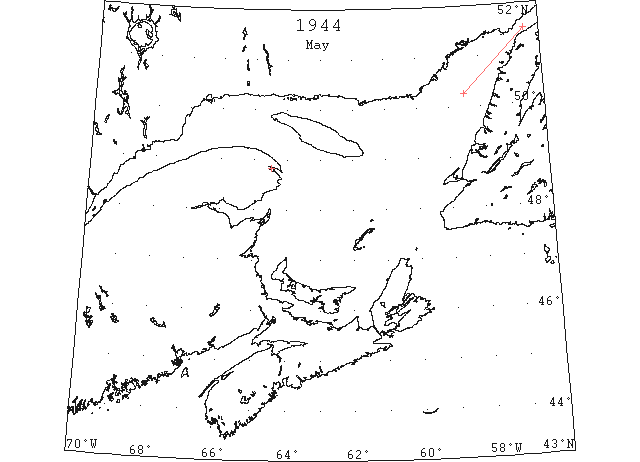
May The Nova Scotian banks were entirely clear by the first of May and the only ice of consequence in the entire St. Lawrence area was that in the Strait of Belle Isle and immediate approaches. (IIP 1946 p48)
May Compact heavy pack with sheets up to a mile and more in diameter extended through the Strait of Belle Isle to a latitude of approximately 50°50’N in the Gulf of St. Lawrence. (IIP 1946)
May 2 Majority of Gaspe Harbour still frozen. (IIP 1946 p67)
May 2 Solid ice across Belle Isle Strait extends to SW in Gulf to southern limit between 50 °15’N and 50°30’W[N?] (IIP 1946 p67)
May 5 Gaspe Harbour mostly open with large areas drifting and solid ice remaining. (IIP 1946 p67)
May 6 Only small pans drifting ice remain in Gaspe Harbour. (IIP 1946 p67)
Jun 9 First Westbound steamer through the strait of Belle Isle. (WBB)