1938 Season
Dec 5 Last eastbound steamer through the Strait of Belle Isle. (WBB)
Jan 2 Last departure of the season from Quebec. (WBB)
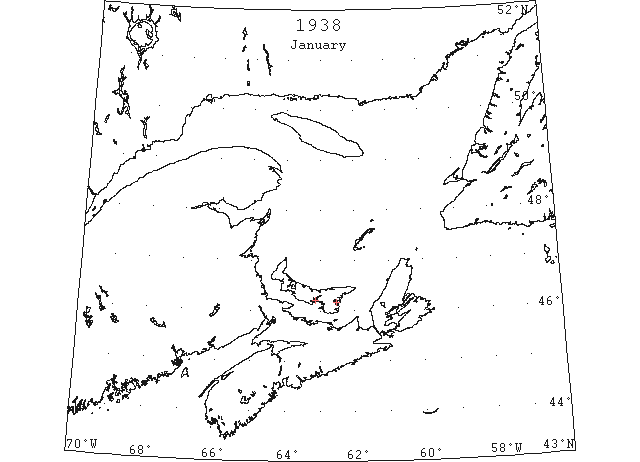
Jan 17 Georgetown – The ferry boat Montague completed her work for the season on the 17th. (Pat 20 Jan p6 c7)
Jan 21 Ice races at Victoria Park, Charlottetown (Friday 21st). (Pat 20 Jan p5 c5)
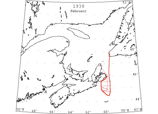
Feb “.. heavy rafted flows of ice were reported moving out of the Gulf of St. Lawrence, between St. Paul Island and Cape North, past Scatari Island blocking the coast of Cape Breton Island and spreading southward over the Scotian Banks toward Sable Island, making passage north of Sable Island dangerous; the coast of Nova Scotia was clear for the most part, at least to Louisburg Harbour, but the ice lay off shore 15 miles at that place and extended eastward to longitude 59°24’W, and S from Scatari Island to latitude 44°40’N, and was moving southward;..” (IIP p19)
Feb 9 Samual Wheeler misses way crossing Humber Arm- Breaks through ice and perishes-Both man and horse had gone through a hole in the ice, in about 4 feet of water, and quite near the shore. (TWS, pg. 1, Col. 6)
Feb 13 The following radiogram [was] received from the U.S. Coast Guard cutter “Tahoe”: a.m. position, 42°30’N 65°22’W. p.m. position, 42°34’N 61°26’W. [no ice noted at vessel’s position] (HB 2528 Feb 16)
Feb 14 The following radiogram [was] received from the U.S. Coast Guard cutter “Tahoe”: a.m. position, 42°38’N 58°03’W. Ice reported sighted late Feb 13, berg, 46°43’N 52°58’W. [no ice noted at vessel’s position] (HB 2528 Feb 16)
Feb 16 “Bristol City” large ice field 44°50’N 60°10’W to 44°50’N 59°51’W. (IIP p.66#24)
Feb 16 “Bristol City” small field scattered ice 44°43’N 60°14’W. (IIP p.66#26)
Feb 16 The following radiogram [was] received from the U.S. Coast Guard cutter “Tahoe”: p.m. Ice reported sighted: Large ice field from 44°50’N 60°10’W to 44°50’N 59°51’W; three growlers aground at Black Rock, Newfoundland. (HB 2529 Feb 23)
Feb 17 The following radiogram [was] received from the U.S. Coast Guard cutter “Tahoe”: a.m.; Ice reported sighted: a small field of scattered ice, 44°43’N 60°14’W. (HB 2529 Feb 23)
Feb 20 “Dromore” large ice field 45°05’N 60°15’W to 45°00’N 59°50’W. (IIP p.67#34)
Feb 20 The following radiogram [was] received from the U.S. Coast Guard cutter “Tahoe”: p.m.; Ice reported sighted: Large ice field from 45°05’N 60°15’W; to 45°00’N 59°50’W. (HB 2529 Feb 23)
Feb 22 “John W. Mackay” heavy field ice extending as far N and S as can be seen 45°13’N 59°24’W to 45°13’N 60°24’W. (IIP p.67#38)
Feb 22 “Montcalm” Cape North to Scatari; east coast, Cape Breton, blocked extending thence S 65 miles. (IIP p.67#42)
Feb 22 The following radiogram [was] received from the U.S. Coast Guard cutter “Tahoe”: a.m.; Ice reported sighted: Heavy field ice extending north and south as far as can be seen from 45°13’N 59°24’W, to 45°13’N 60°24’W. p.m.; Ice reported sighted: Heavy field ice 8 miles off coast at Louisburg, Cape Breton Island; heavy slob ice 10 miles offshore in all directions from Cape Race. (HB 2530 Mar 2)
Feb 23 Ice compelled Caribou to go to Louisburg- On her mid-week trip across the Cabot Strait last week, the SS “Caribou” was unable to get into Sydney owing to the harbor being blocked with ice, and had to go to Louisburg. It has not been unusual in recent years to encounter such ice troubles so early in the season. (TWS, pg. 1, Col. 3)
Feb 23 The severe frost of the past week has frozen the harbor over solidly and teams are now busily engaged hauling firewood to Sandy Point. (TWS, pg. 1, Col. 4)
Feb 23 The drift ice is packed into Codroy, making a compact bridge to Codroy Island. (TWS, pg. 2, Col. 2)
Feb 23 The following radiogram [was] received from the U.S. Coast Guard cutter “Tahoe”: a.m.; Louisburg Harbour and vicinity clear of drift ice; east coast of Cape Breton Island blocked by ice from Cape North to Scatari Island, and ice extends from there southward for 65 miles. (HB 2530 Mar 2)
Feb 27 The following radiogram [was] received from the U.S. Coast Guard cutter “Tahoe”: a.m. position, 43°33’N 58°26’W. No ice sighted or reported sighted. p.m. position, 43°45’N 61°30’W. Bound for Halifax for supplies and some repairs. Ice reported sighted: Close-packed ice in all directions from Cape Race. Ice summary this date follows: Heavy rafted ice moving out of the St. Lawrence passed Scatari Island making any passage north of Sable Island dangerous. (HB 2530 Mar 2)
Feb 28 The following radiogram [was] received from the U.S. Coast Guard cutter “Tahoe”: a.m. position, 44°28’N 63°22’W. No ice sighted or reported sighted. (HB 2530 Mar 2)
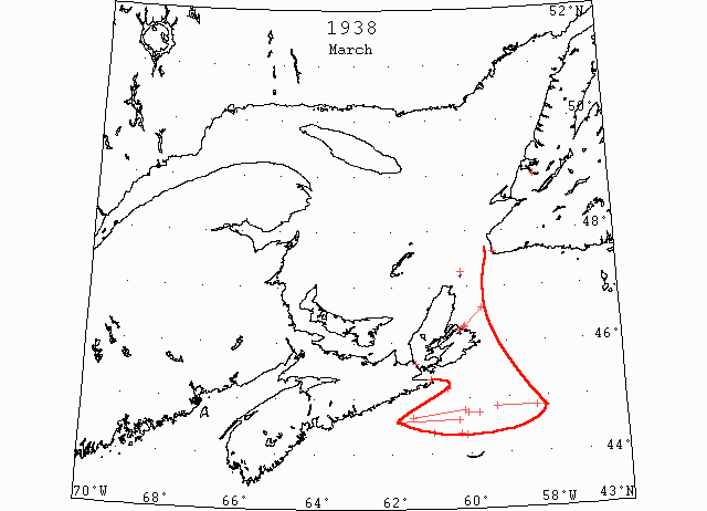
Mar “… conditions N of Sable Island and in Cabot Strait improved during the month but heavy rafted pan ice was still moving out of the Gulf of St. Lawrence and this route was still closed.” (IIP p20)
Mar 2 Owing to the ice floe in Cabot Strait the SS “Caribou” had to make Louisburg her connecting port on her trips for more than a week now. However the ice has not interfered with her making this port on her return trips. So far the fishermen have been interrupted little by ice and it is hoped this favorable condition will continue (Channel- Port aux Basques). (TWS, pg. 1, Col. 3)
Mar 2 North Sydney: Newfoundland Government steamer “Caribou” was forced to put into Louisburg to land passengers from Port aux Basques, Newfoundland, today after spending several hours outside North Sydney harbor, trying to break through heavy ice. The “Caribou,” in command of Captain Tavenor, had about 50 passengers aboard as well as mail and general cargo. (HH 03/03/1938 p9#7)
Mar 3 Canso: The SS “O-We-ra,” plying between the ports of Canso, Arichat and Mulgrave, was unable to make her return trip to Canso from Mulgrave Monday owing to ice conditions in the Strait of Canso. The ice-breaker “Brant” after breaking ice in Canso harbor will proceed up Chedabucto Bay to Guysboro. Steamer “Chedabucto” was delayed here overnight on account of ice conditions. (HH 04/03/1938 p12#7)
Mar 9 During the past weeks the SS “Caribou” has had to go to Louisburg, as Sydney Harbor has been blocked with ice. (TWS, pg. 1, Col. 3)
Mar 9 The following radiogram [was] received from the U.S. Coast Guard cutter “Tahoe”: p.m. position, 44°30’N 62°48’W. No ice sighted or reported sighted today. (HB 2532 Mar 16)
Mar 10 “Tahoe” large patches slob ice and some pieces 44°34’N 61°47’W to 44°36’N 60°18’W. (IIP p.67#65)
Mar 10 “Stavengerfjord” broken field ice N of track 44°50’N 59°20’W to 44°50’N 58°18’W. (IIP p.67#66)
Mar 10 “Grey County” slob ice and some pieces as far as can be seen 45°10’N 60°35’W. (IIP p.67#67)
Mar 10 “Stavengerfjord” patches slob ice and some pieces 44°46’N 60°09’W to 44°39’N 61°28’W. (IIP p.67#68)
Mar 16 Ice harvesting from Humber Arm has been in progress the past week or ten days. The crop is a good one this year, 20-inch blocks of good blue ice. (TWS, pg. 2, Col. 3)
Mar 21 Reporting an uneventful trip from Newfoundland, the Old Colony passenger and freight steamer “Northern Ranger” was at Pier 22 yesterday. Gulf ice was sighted 100 miles south east of Scattarie. The “Northern Ranger” was over a course forty miles north of Sable Island and no ice was seen. The vessel encountered dense fog before reaching Halifax. (HH 22/03/1938 p12#8)
Mar 23 The ice is packed in close and no water can be seen in the Gulf. Many people attribute the ice as the cause to this wonderful weather. (TWS, pg. 2, Col. 5)
Mar 24 “Tahoe” field ice extending N as far as can be seen 44°44’N 59°47’W to 44°44’N 60°03’W. (IIP p.69#128)
Mar 26 The following radiogram [was] received from the U.S. Coast Guard cutter “Pontchartrain”: a.m.; Ice reported sighted today: … heavy rafted pan ice in all directions from St. Paul Island, Cape Breton, with some open water to the eastward. (HB 2534 Mar 30)
Mar 26 The Hydrographic Office at Boston Saturday ordered the ‘Great Circle’ route between North America and Europe ninety miles southward because of the early appearance of icebergs off Newfoundland. Ice was not due in that section for another week, the bureau indicated. The formal notice called for the immediate abandonment of ‘Track C’ in favor of ‘Track B.’ The North Atlantic route is divided into tracks, the bureau explained under an international agreement between commercial shipping agencies, for the purpose of safety. The order was a result of information dispatched by watching patrols two days ago. Vast quantities of slob ice a heavy skim, also were reported near the Grand Banks. (HH 28/03/1938 p14#8)
Mar 29 “Fort Amherst” widely separated strings of field ice 44°22’N 60°15’W. (IIP p.69#155)
Mar 30 “Newfoundland” scattered field ice 44°23’N 60°56’W to 44°20’N 60°06’W. (IIP p.70#160)
Mar 30 On Mon. the SS “Caribou” was reported jammed in ice off Low Point, Cape Breton, on her way from North Sydney. A change in wind is necessary before she can get clear. (TWS, pg. 2, Col. 4)
Mar 30 North Sydney: The “Caribou” remained jammed in heavy ice off Low Point lighthouse near the entrance to Sydney harbor tonight, her fourth night in the floes. The “Caribou” left North Sydney Sunday evening for Port aux Basques, Newfoundland, but had proceeded only a short distance before a change of wind brought heavy ice inshore, jamming the vessel fast. Engines have been shut down and the ship is waiting for a west wind to break up the floes before she can proceed. It was estimated the ice extended about 30 miles off the harbor. Albert Briand, one of the passengers on the “Caribou” when she left Sunday, arrived here this afternoon, after walking ashore at Low Point. He left 24 other passengers aboard the vessel, making the trip with P J Cadegan of Glace Bay, and two members of the crew of the “Caribou,” Steve McDonald and Albert Matthews. The quartet took three hours to cover the 2 ½ miles separating the ship from shore, finding the ice treacherous at times. (HH 31/03/1938 p9#6)
Mar 31 North Sydney: The steamship “Caribou,” specially equipped to battle ice, seemed to be winning a five-day battle with close-packed ice off Sydney harbor, tonight. After fighting helplessly against the pack since Sunday night without moving more than 2 ½ miles off the coast, the “Caribou” had battled her way out of sight of land tonight, with grinding floes still surrounding her, but clear water is sight. As the “Caribou” forged slowly outward toward Port aux Basques, the ice-breaker “Montcalm” was gradually breaking her way toward port, conquering one of the worst jams in recent years. (HH 01/04/1938 p9#7)
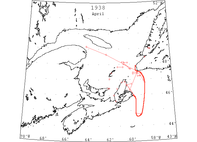
Apr “The St. Lawrence Ice Patrol began about April 6 and the route through the gulf was open for traffic April 8. Heavy floes of rafted ice, however continued to move out on the southern side of Cabot Strait throughout the month and extended E of Scatari Island, Cape Breton Island, at least 55 miles. Ships entering the gulf passed close to Cape Ray, Newfoundland, in order to avoid ice which was repeatedly reported S of that point and open pans of ice existed within the Gulf of St. Lawrence along the track from Cape Ray to Anticosti during most of the month. (IIP p.20)
Apr 3 North Sydney: The 15 ton schooner “Mary Isabelle” arrived here today from Ingonish, CB, first schooner of the year to make port. Captain Donovan reported he had taken the shore route and had escaped most of the ice, which is fast disappearing. (HH 04/04/1938 p9#4)
Apr 5 The following radiogram [was] received from the U.S. Coast Guard cutter “Tahoe”: p.m. position, 43°10’N 51°48’W. The “Tahoe” relieved the “Pontchartrain” this date. (HB 2536 Apr 13)
Apr 6 The harbor ice in the shoal water has completely broken up. Only one strip between Turf Point and Messervey Island is still holding on, but is getting rather unsafe for teams (Codroy). (TWS, pg. 1, Col. 3)
Apr 6 The ice over Humber Arm is becoming weak in places, and on Sat. oxen broke through at several places. (TWS, pg. 2, Col. 4)
Apr 6 Although we are not having any rain the snow is disappearing as if by magic. A break-up is expected any time now. Several horses have broken through the ice. (TWS, pg. 3, Col. 3)
Apr 6 Over 500 people gathered on the Harbor ice on Sun last to witness the annual horse race… The ice was in splendid condition (St. Georges’). (TWS, pg. 3, Col. 4)
Apr 6 The first trip last year [by the Pictou-Pictou Landing Ferry “Ashagola”] was made April 6. (HH 13/04/1939 p9#8)
Apr 8 “Montcalm” Flat Point, Cape Breton Island to 46°43’N 59°53’W broken heavy open ice, thence clear water to Cape Ray. (IIP p.71#241)
Apr 8 “Montcalm” Bird Rock, soft slob and pan ice, 20 miles E. (IIP p.71#243)
Apr 8 “Montcalm” Gulf of St. Lawrence, open water with scattered heavy rafted pan ice all through as far as Anticosti Island, passable during daylight hours. (IIP p.71#244)
Apr 8 “Montcalm” Cape North to and beyond Scatari Island, heavy pieces rafted along E coast Cape Breton. (IIP p.71#245)
Apr 8 The following radiogram [was] received from the U.S. Coast Guard cutter “Tahoe”: April 9, a.m.; Ice reported sighted April 8: Heavy pieces of rafted ice along the east coast of Cape Breton extending from Cape North to and beyond Scatari Island. Open water with scattered heavy rafted pan ice all through as far as Anticosti Island, passable during daylight hours. p.m.; Ice reported sighted today: Strings of slob ice from 44°49’N 59°33’W to 44°45’N 59°08’W, extending as far north as can be seen; growler 10 miles southeast from Cape Race. (HB 2536 Apr 13)
Apr 10 First arrival of season at Quebec. (WBB)
Apr 12 The Department of Transport issued the following report on ice conditions yesterday: Mulgrave, a little loose scattered ice in Strait. Port Hood bay full of ice north of Port Hood and South Elmira (East Point, PEI). Strong west-southwest breeze pushing ice off shore. Ice breaking up in strait. Considerable clear water southwest Canso. Few pieces coming out of bay. (HH 13/04/1938 p15#6)
Apr 13 The ship channel of the St. Lawrence River has been announced clear of ice from Montreal to the sea. (TWS, pg. 4, Col. 5)
Apr 13 There is very little difference in ice conditions in Humber Arm as compared with this date last year. On 21st Apr water extended down to Summerside and on 23rd the Arm became free. Yesterday a boat crossed the Arm from Petipas’ Cove. In the center of the Arm the water extends below Curling. (TWS, pg. 2, Col. 3)
Apr 20 “John W. Mackay” field ice 47°15’N 59°00’W to 46°47’N 58°38’W. (IIP p.76#555)
Apr 20 “John W. Mackay” field ice extending eastward 47°10’N 58°45’W to 46°55’N 58°42’W. (IIP p.76#556)
Apr 20 Grindstone, Magdalen Islands – Thick fog. No ice reported. (HH 20/04/1938 p15#7)
Apr 21 The following ice broadcast received from radio branch, Department of Transport yesterday. Port Hood: some open water north and south in bay. Mulgrave: Strait clear of ice Elmira, light southwest wind dense fog visibility nil, Canso: No observation, dense fog. (HH 21/04/1938 p16#8)
Apr 22 “Duchess of Atholl” open field ice 47°15’N 59°03’W. (IIP p.76#579)
Apr 22 The following radiogram [was] received from the U.S. Coast Guard cutter “Pontchartrain”: a.m.; Ice reported sighted today: Patch of open field ice, 47°18’N 59°03’W. p.m.; Ice reported sighted today: open field ice, 47°18’N 59°03’W. (HB 2538 Apr 27)
Apr 22 Grindstone, Magdalen Islands surrounded by drift ice. (HH 22/04/1938 p14#6)
Apr 23 The following message was received yesterday from the icebreaker “Montcalm,” via the district superintendent of radio. Patrolled steamer track from Cape Ray to thirty-two miles south by west from South Point Anticosti. Any ships bound in at present will find best tracks as follows: Clear water all along Newfoundland coast from St. Pierre to six miles off Cape [Ray] then steer to pass twenty-five miles off south point Anticosti then [eig]hteen miles off Cape des Rosiers. Broken strings of ice with scattered heavy rafted pans all through it but more open water than ice. String of ice along east coast Cape Breton extending from Cape North to and beyond Scatarie, opening and spreading towards west coast of Newfoundland. Track via Gut of Canso not recommended at present. Another ice report from the radio branch follows: Port Hood: some open water north and south in Bay Elmira. Light north wind with thick fog light rain visibility nil. Canso dense fog no observation. (HH 23/04/1938 p21#8)
Apr 24 “Andania” heavy field ice extending N and S, 48°09’N 60°43’W. (IIP p.77#615)
Apr 24 “Montcalm” field ice 48°01’N 60°35’W. (IIP p.77#616)
Apr 24 “Andania” several strings heavy field ice 48°09’N 60°43’W to 48°07’N 60°14’W. (IIP p.77#617)
Apr 24 “Montcalm” field ice 48°01’N 60°35’W to 47°42’N 59°56’W. (IIP p.77#618)
Apr 24 “Montcalm” field ice extending 10 miles 47°13’N 59°15’W. (IIP p.77#619)
Apr 25 “Beaverdale” field ice 48°08’N 60°35’W to 47°42’N 60°00’W. (IIP p.77#631)
Apr 25 “Beaverdale Cape Ray, field ice 15 miles S extending E and W 17 miles. (IIP p.77#633)
Apr 25 “Duchess of Bedford” Cape Ray, field ice 10 miles S extending to lon. 59°00’W. (IIP p.77#635)
Apr 25 Grindstone, M I – Magdalen Islands surrounded with open drift ice. (HH 25/04/1938 p14#8)
Apr 26 The following report on ice conditions was released yesterday by the radio branch, department of Transport. Mulgrave, no ice in strait; Port Hood, ice all clear north and south of here; Elmira, scattered drift ice north and east, mostly clear in strait; Canso, nothing observed, dense fog. (HH 27/04/1938 p13#7)
Apr 27 Navigation on the St. Lawrence River for ocean ships was opened last Mon. by the arrival at Montreal of the liner Duchess of Bedford from England. (TWS, pg. 4, Col. 5)
Apr 27 The 1,140 ton Norwegian freighter “Lido” was caught in heavy ice 37 miles north of East Point, PE Island, Northeastern tip of the island, Foundation Maritime reported here today. She was not in any immediate danger. (HH 27/04/1938 p9#4)
Apr 27 Grindstone, Magdalen Islands surrounded with drift ice. Pleasant bay full. (HH 27/04/1938 p13#6)
Apr 27 North Sydney: For the second time this week the SS “Kyle” was delayed in reaching this port from Port aux Basques and the steamer was over six hours behind schedule arriving here Saturday. Running into ice when ten miles off Channel Head the ship was forced to plow through loose ice until off Flat Point. (HH 28/04/1938 p15#7)
Apr 28 Grindstone – Magdalen Islands surrounded with open drift ice. Pleasant Bay partly full of ice. (HH 28/04/1938 p15#8)
Apr 29 The following report on ice conditions was received yesterday from the radio branch, Department of Transport: Port Hood, bay clear of ice; Mulgrave, northwest wind clear, no ice in strait; Elmira, light southwest wind, fair, cool, scattered drift ice off shore north and south; Canso, no ice in sight. (HH 30/04/1938 p16#5)
Apr 30 Grindstone – Magdalen Islands surrounded with open ice. Pleasant Bay clear. (HH 30/04/1938 p16#8)
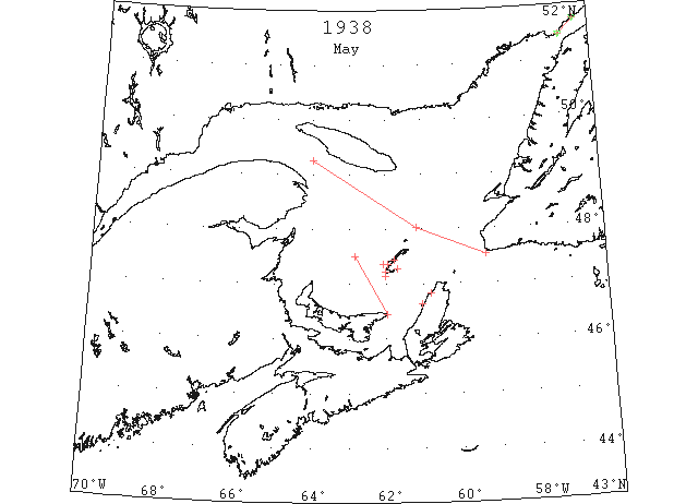
May “The St. Lawrence Ice Patrol was discontinued on May 10 with the disappearance of all the heavy ice from the gulf. Reports from the Belle Isle, Newfoundland, area indicated tight ice in the North Channel, and at Point Amour, Newfoundland, and Red Bay, Labrador. (IIP p21)
May 1 Cheticamp: Motor vessel “Nova II” was here this week from Halifax. The vessel had no difficulty making the harbor although there were ice floes along the coast and at the harbor entrance. (HH 02/05/1938 p12#8)
May 2 Grindstone, M I – Magdalen Islands surrounded open drift ice. Pleasant Bay full. (HH 02/05/1938 p12#8)
May 2 The following report on ice conditions was released yesterday by the radio branch, Department of Transport: Gut of Canso via Northumberland Strait, no ice via East Point, PEI. Strings and patches of soft broken ice in the vicinity of East Point, PEI to Braddelle Bank. Elmira – No ice in sight. Mulgrave – No ice in sight. Port Hood, Canso – No ice visible. (HH 03/05/1938 p12#6)
May 3 Grindstone – Magdalen Islands still surrounded with open ice. Pleasant Bay clear. (HH 03/05/1938 p12#6)
May 3 The following report on ice conditions was released yesterday by the radio branch, Department of Transport: Mulgrave, northwest wind, cloudy, no ice in strait; Elmira, fresh north wind, no ice in sight; Port Hood, no ice visible in bay; Canso, no ice in sight. (HH 04/05/1938 p10#8)
May 3 The SS “Fleurus” docked here Sunday from Quebec and Montreal. Heavy ice was reported in the Gulf of St. Lawrence off East Point, PEI. (HH 04/05/1938 p10#6)
May 4 The ice has left us and Mr. Wallace Ruth has been the first to launch his boat. (TWS, pg. 6, Col. 4)
May 4 Grindstone – Magdalen Islands surrounded with open drift ice. Pleasant Bay clear. (HH 04/05/1938 p10#8)
May 5 Grindstone, MI – Amherst and Etang du Nord about five to ten miles open ice along shore. Grosse Isle, Old Harry and Pleasant Bay clear of ice. (HH 05/05/1938 p14#7)
May 5 Pictou: The SS “Lovat” docked here Tuesday night from the Magdalen Islands after being delayed for two days by heavy drift ice. A northwest wind Sunday shifted the ice so that the ship was able to get to Entry Island, but that afternoon it shifted southwest, and packed the ice inshore again, so that the vessel had a difficult passage through it on Pleasant Bay. The SS “Keystate” docked in Pictou yesterday morning from Montreal. Northumberland Strait was free of drift ice. (HH 06/05/1938 p14#6)
May 6 Grindstone – Magdalen Islands clear of drift ice. (HH 06/05/1938 p14#8)
May 6 The following report on ice conditions was released yesterday by the radio branch, Department of Transport: Elmira, no ice in sight; Port Hood, no ice visible in bay; Mulgrave, no ice in strait; Canso, no ice in strait. (HH 06/05/1938 p14#7)
May 7 Grindstone, M I – Magdalen Islands clear of ice. (HH 07/05/1938 p19#8)
May 9 The following report on ice conditions was released yesterday by the radio branch, Department of Transport yesterday: Ships bound in and outward at present will find best track as follows: Clear water all along Newfoundland coast from St. Pierre to six miles off Cape Ray then steer to pass ten to twelve miles off Bird Rock, then any desired course to the Gaspe coast. Broken strings of ice will probably be met with scattered pans all through it but more open water than ice. Ice on east coast of Cape Breton moving out. Track Gut of Canso via Northumberland Straits clear of ice. Elmira, no ice in sight; Port hood; no ice in bay; Mulgrave; no ice in strait; Canso, no ice in sight. (HH 10/05/1938 p12#5)
May 19 Point Amour: heavy close packed ice everywhere. (IIP p.85#1203)
May 20 First Westbound steamer through the strait of Belle Isle. (WBB)
May 21 Belle Isle: Point Amour to Red Bay heavy close packed ice in all directions. (IIP p.87#1333)
May 22 Belle Isle: Point Amour to Red Bay heavy open ice offshore. (IIP p.88#1447)
May 24 Belle Isle: Point Amour scattered ice as far as can be seen. (IIP p.89#1558)
May 24 Belle Isle: Red Bay, heavy loose ice and 1 berg. (IIP p.89#1559)
May 26 Belle Isle: Point Amour, close packed light ice moving E along shore, scattered heavy ice offshore. (IIP p.91#1650)
May 26 Belle Isle: Red Bay, scattered ice moving E 5 miles offshore. (IIP p.91#1651)
May 27 Belle Isle: Point Amour, light ice along shore moving E. (IIP p.92#1726)
May 28 Belle Isle: Point Amour, loose ice along shore. (IIP p.92#1769)
May 28 Belle Isle: Red Bay, 2 bergs. (IIP p.92#1727)
May 29 Belle Isle: Point Amour berg and growler. (IIP p.93#1827) [bergs thereafter]
May 29 Belle Isle: Red Bay 3 bergs. (IIP p.93#1828) [bergs thereafter]