1934 Season
Dec (beginning) Pilotage officer, Father Point: Ice starts making. (CIS IC0708_2)
Dec 5 Much ice below Quebec. (RG42 Vol.371)
Dec 6 The severe winter weather of late has accumulated a lot of ice on the harbor making it impossible for the ferry to cross. This is quite a hardship to the people of Sandy Point, who have to make connections with trains. (TWS, p.2).
Dec 9 Last eastbound steamer through the Strait of Belle Isle. (WBB)
Dec 11 “Grete Glad” has been caught in ice off Father Point for a couple of days. “Mikula” going to her assistance. (RG42 Vol.371)
Dec 12 7 ships stuck in ice off Father Point. “Mikula” looking after them. 2 have cleared and report safe. North side practically clear water from Saguenay to below Pointe des Monts. (RG42 Vol.371)
Dec 13 Last departure of the season from Quebec. (WBB)
Dec 15 “N.B. McLean”: 8 am. Reports 14 miles N of Metis with 3 ships, River frozen from shore to shore with young ice sufficiently heavy to stop a ship; heavy ice along S shore. Will proceed with convoy until danger of sticking is past. (RG42 Vol.371)
Dec 16 Convoy of 3 ships that as escorted to near Pointe des Monts yesterday reported last night that they were stuck in ice about 17 miles off Cape Chat. “N.B. McLean” then at Father Point; proceeded again to their assistance this morning. (RG42 Vol.371)
Dec 19 Car ferry taking longer to cross due to increasing heaviness of ice. (Pat 19 Dec p8 c3)
Dec 20 Crossing was made on the ice from Summerside to Curling Saturday. (TWS, p.2).
Dec 20 The SS “Sagona” arrived at Humbermouth, from the Straits Mail service, Saturday afternoon. Since then the ship has been busy ice-breaking and releasing ships from Corner Brook. The steamer is scheduled to sail north again today. (TWS, p.2).
Dec 20 The weather man during the month of December has been giving us a variety of weather stunts, from zero weather and blinding snow storms to thunder and lightning and torrential rains and high temperatures. Twice St. George’s Harbor has frozen across and moved out again. (TWS, p.2)
Dec 21 Heavy ice in Pictou Harbour today forced the steamer “Kem” to return to the wharf. SS “Lovat” from Magdalenes arrived at 2 p.m. and successfully smashed through the ice of the harbour. (Pat 21 Dec p1 c4)
Dec 21 “Lovat” making last trip of season to Magdalene Islands when she was caught in ice at Souris, PEI last of December. When sub zero weather spread a heavy sheet of ice over Souris Harbour. “Lovat” asked “Montcalm” to release her but “Montcalm” assisting steamer “Aranda” through ice off Bonaventure Island. Next few days Souris ice thickened and held “Lovat” and Norwegian freighter “Solburg” hard and fast. (Pat 6 Mar 1934 p4 c7)
Dec 23 Lightkeeper, East Point, PEI: Ice formed in vicinity. (CIS IC0993)
Dec 25 J.A. Ward, Lightkeeper, Miscou Point, New Brunswick: Closing date. (CIS IC0756_3)
Dec 27 Clipping from the Guardian 27 Dec 1933: The Norwegian steamer “Solhaug” loading potatoes last Wednesday at Souris left that port for Georgetown but was unable to get out owing to the freeze up of the harbour. SS “Lovat” is also frozen up at Souris. Yesterday the SS “Montcalm” was reported about 14 miles south and 13 miles east of Bonaventure Island with the SS “Aranda” in heavy sheet ice. Practically the entire Gulf is covered by ice. The steamer remained until late in April (1934). (Pat 4 Jan 1936 p6 c4)
Dec 27 Disease had been added to the torments of those suffering from the pangs of hunger in the little villages lying in the shadow of Cape Smokey on Cape Breton’s North Shore. Shore villages have been isolated since December 27th. On that date the ice froze small boats of the fisherfolk in the small harbors and blocked entrance of shipping from outside. Weather colder and stormier than the oldest inhabitants can remember has brought added tortures. When the teachers were unable to sail by boat they traveled over the hill country with the temperatures as low as 27 degrees below zero. Ice that sealed bays, harbors and inlets, ice that covered lakes and streams, slob ice and great fields of ice as far as the eye could reach spread out in a vast panorama as an open-cockpit airplane carried me along Cape Breton’s north shore from Halifax via Sydney. North Sydney harbor alone was open. A blue fringe of open water skirted the frozen shore. On one side lay the frozen bays and harbors and on the other the ice fields. (HH 27/01/1934 p1#7,8 ; p4#2,3)
Jan Gulf of St. Lawrence ice was reported during the month75 miles SE of Cape Breton. Light slob and pancake ice was reported during from Halifax eastward to 59°46’W. (IIP p21)
Jan 1 Charlottetown, the steamers “Lovat” and “Colbaug” are still ice-bound at Souris and probably will be forced to remain there all winter. Relief from the government ice-breaker “Montcalm” had been anticipated, but a message from her today stated that she was off Bonaventure Island assisting the steamer “Arnada” through heavy sheet ice. Meanwhile the surface on Souris Harbor is thickening in a day or two the “Montcalm” will not be able to enter. The “Lovat” on the Halifax-Magdalen Islands route had just about completed her season and her delay will not be serious. (HH 02/01/1934 p2#8)
Jan 2 Grindstone and Etang du Nord and Grosse Isle, close packed ice as far as can be seen. Amherst Island, open ice about 2 to 3 miles from shore. Pleasant Bay, full of light slob ice. West Point, no ice in sight. Heath Point, light close packed ice everywhere. Souris, harbour frozen over. No ice in sight, but heavy ice reported outside. Georgetown, some open water. Ice visible outside. (RG42 Vol.371)
Jan 3 Father Point, packed ice everywhere. Fame Point, heavy close packed ice everywhere. Bersimis, light close packed ice everywhere. West Point light open ice stationary. Heath Point, close packed ice everywhere, distant. Grosse Isle, Old Harry, Etang du Nord all have close packed ice as far as can see. Amherst, close packed ice 2 miles off shore. Pleasant Bay, half full of light ice. Souris, harbour frozen over. Heavy drift ice outside. Georgetown, Ice conditions unchanged since yesterday. Pictou, harbour ice bound. (RG42 Vol.371)
Jan 4 Cape Salmon, Light fog reducing some visibility: heavy, close packed ice everywhere. Father Point, Packed ice everywhere. Bersimis, No ice in sight. Fame Point and Heath Point have heavy, close packed ice everywhere. Point des Mont’s, Light, close packed ice everywhere. West Point, light open ice, stationary. Grosse Isle and Old Harry, all open ice. Etang du Nord, close packed ice. Pleasant Bay, full of slob ice. Georgetown, harbour is solid, and there is some open water in sight outside. Souris and Pictou, both have solid harbours. (RG42 Vol.371)
Jan 5 Cape Salmon, Considerable open ice. Bersimis, Light open ice, distant. Father Point, Packed ice everywhere. Fame Point and Heath Point, Heavy close packed ice everywhere. West Point, Light close packed ice in shore. Pleasant Bay, about 5 miles close packed ice. Grosse Isle and Etang du Nord and Amherst Island, close packed ice as far as can be can be seen. Souris, ice and weather conditions unchanged. Pictou, harbour is ice – bound. Georgetown, open water and drift ice visible in Gulf. Sheet ice in harbour. (RG42 Vol.371)
Jan 6 Bersimis, blinding snowstorm. Points des Mont’s, snowing and light open ice in shore. Father Point, snowing and packed ice everywhere. Fame Point, snowing and heavy open ice is everywhere. West Point, snowing and heavy close packed ice. (RG42 Vol.371)
Jan 8 Bersimis, heavy close packed ice distant. Point des Monts, heavy open ice everywhere. Father Point, packed ice everywhere. Fame Point, heavy close packed ice everywhere. (RG42 Vol.371)
Jan 8 C.G.S. “Mikula”, 8 A.M. position 46°42‘N 63°09‘W. From 4 P.M position yesterday, 50°07’N 65°41’W, through Sheldrake then to West Point, Anticosti, slob ice. The heavy ice was about 5 to 10 miles off shore. From West Point to present position heavy close packed ice with occasional small leads of open water. “Mikula” jammed often during the night. Expect to reach “Montcalm” today. (RG42 Vol.371)
Jan 9 Bersimis, light close packed ice everywhere. Point des Monts, no ice in sight. Father Point, packed ice everywhere. Fame Point, heavy close packed ice everywhere. West Point, light open ice everywhere. (RG42 Vol.371)
Jan 10 Cape Salmon, heavy close packed ice everywhere. Bersimis, light close packed ice everywhere. Point des Monts, No ice in sight. Father Point, packed ice everywhere. West Point, light open ice stationary. (RG42 Vol.371)
Jan 10 C.G.S. “Mikula”, started daybreak with agenda. 9 A.M. position 48°13 ‘ N. 63°11’ W. Heavy close packed ice, with occasional new ice between. (RG42 Vol.371)
Jan 12 Quebec, the government icebreaker “Mikula,” escorting the icebreaker “Montcalm” and lumber laden “Aganda” to North Sydney, Nova Scotia, reported today by wireless that ‘fairly good progress’ was being made. She gave her position as 14 miles southeast of South Point, Anticosti Island. With heavy ice deterring progress somewhat, the three ships have covered approximately 100 miles since Wednesday. It is expected that with more open leads of water in sight at present, better progress will be made today and tomorrow. (HH 13/01/1934 p19#5)
Jan 13 45°13’N 58°18’W. Small field of ice. (IIP p24#3).
Jan 16 Cape Salmon, no ice in sight. Point des Monts, light close packed ice distant. Cape Ray and Cape Anguille, light open ice distant. West Point, light open ice inshore. Father Point, packed ice everywhere. Fame Point, heavy close packed ice everywhere. (RG42 Vol.371)
Jan 16 C.G.S. “Mikula” 8 A.M.- 48°04 ‘N. 61°09 ‘ N. Started daybreak, ice close packed, progress is poor. 4 P.M. 15th – 48°06 ‘N. 61°16 ‘W. close packed ice. (RG42 Vol.371)
Jan 17 Cape Salmon and Bersimis, no ice in sight. Point des Monts, heavy close packed ice distant. Father Point, heavy close packed ice everywhere. Fame Point, heavy open ice everywhere. West Point, light open ice in shore. (RG42 Vol.371)
Jan 17 C.G.S “Mikula”, 8 A.M. – 9 miles south of St. Paul’s Island. Ice well broken. Made good progress to North Sydney with steamer “ Aranda “. Very glad to see her almost clear of ice. 2:35 P.M. – left steamer “Aranda “ clear of ice 12 miles N.E. from Flint Island. She proceeded to Halifax. Position of “Mikula” 4 P.M. 46°25’N. 59°50’W. (About 20 miles N.E. of Sydney). Stopped in light broken ice. (RG42 Vol.371)
Jan 17 Heavy slob ice impeded the progress of three steamers today as they battered a way through the Gulf of St. Lawrence to North Sydney, Nova Scotia. The government ice-breaker “Mikula” with the icebreaker “Montcalm” and the steamer “Aramba” were making slow progress. They were nine miles off Bird Rock, 40 miles to the northwest of Cape St. Lawrence. Indications were they would soon be clear of the floes. They had been in the ice for more than a week. The “Mikula” went to the assistance of the other two ships when they became caught further north. (HH 17/01/1934 p13#4)
Jan 18 Cape Salmon and Bersimis, no ice in sight. Point des Monts, heavy close packed ice distant. West Point, light open ice stationary. Fame point, heavy close packed ice everywhere. Father Point, packed ice everywhere. (RG42 Vol.371)
Jan 19 Cape Salmon, light open ice. Bersimis, no ice in sight. Point des Monts, light open ice everywhere. Father Point, packed ice everywhere. Fame Point, heavy close packed ice everywhere. West Point, light open ice everywhere. (RG42 Vol.371)
Jan 20 Cape Salmon, packed ice everywhere. Bersimis, no ice in sight. Point des Monts, light open ice distant. Father Point, packed ice everywhere. Fame Point, heavy close packed ice everywhere. West point, heavy open ice stationary. (RG42 Vol.371)
Jan 20 After battling her way through ice for more than three weeks the lumber laden Norwegian freighter “Aranda” reached Halifax yesterday morning twenty-three days out of Charleton, Quebec. ‘It was the worst voyage I have ever experienced’, said Captain A T Abrahamsen, master of the sturdy freighter as he stepped ashore from his ship. ‘It was just a solid ice field from the time we left Charleton until we reached the Cape Breton coast. The ice was from a foot and a half to three feet in thickness and at times the temperature was twenty-five below zero’, he added. The ship’s propeller blades are broken and she is leaking. Several of her plates are dented, said the skipper. The “Montcalm” assisted the “Aranda” for three weeks and when she herself ran into difficulties, the powerful icebreaker “Mikula” came to the assistance of both and remained with them for them for ten days. (HH 20/01/1934 p11#6)
Jan 21 Norwegian steamer “Aranda” limped into Halifax yesterday after a long battle with ice and storm down through the floes of the Gulf of St. Lawrence. Taken more than 3 weeks to get from Carleton, Quebec to Halifax. (Pat 22 Jan p1 c3)
Jan 22 Cape Salmon, heavy close packed ice everywhere. Bersimis, no ice in sight. Father Point, packed ice everywhere. Fame Point, heavy close packed ice everywhere. West Point, light open ice in shore. (RG42 Vol.371)
Jan 22 It was cold at Halifax yesterday – so cold that ice formed on the harbor for the first time in 10 years. The ice extended beyond George’s Island, but it was a thin coasting and was no hindrance to shipping even for the few hours it was to be seen. [difficult to read] (HH 22/01/1934 p14#2)
Jan 22 Halifax Harbour covered with ice for first time in 10 years. (Pat 22 Jan p1 c7)
Jan 23 Cape Salmon, light open ice. Bersimis, no ice in sight. Pointe des Monts, heavy close packed ice everywhere. Father Point, packed ice everywhere. Fame Point, heavy open ice everywhere. West Point, light open ice stationary. (RG42 Vol.371)
Jan 24 Halifax to 44°44’N 59°46’W. Light slob and pancake ice. (IIP p24#12)
Jan 24 44°48’N 59°00’W to 44°49’N 58°30’W. Field ice stretching to northward. (IIP p24#13)
Jan 24 The SS “Caribou” encountered much difficulty with ice on her last trip to North Sydney. On Sunday she was reported off Low Point, and did not reach North Sydney until Monday night. She left again yesterday morning, and was due at Port aux Basques at 5 p.m. Her train delayed at Port aux Basques since Sunday night was due here last midnight. (TWS, p.2).
Jan 25 Bersimis, no ice in sight. Pointe des Monts, heavy close packed ice distant. Father Point, packed ice everywhere. Fame Point, heavy open ice everywhere. Cap des Rosiers, heavy open ice for 3 miles in shore, Heavy close packed ice distant. West Point, light open ice in shore. Inverness, ice broken and piled strongly in bay. Port Hood, bay blocked with heavy ice. Souris, heavy ice in this vicinity. Elmira, solid ice on shore. Point Tupper, close packed ice distant northward; open ice southward. St. Pauls Island, ice in all directions, some open water in southerly direction. (RG42 Vol.371)
Jan 26 Ice everywhere from Quebec to Cape Dog. (RG42 Vol.371)
Jan 26 Cape Salmon. heavy open ice everywhere. Bersimis, no ice in sight. Points des Monts, light open ice in shore. Father Point., packed ice everywhere. Fame Point, heavy close packed ice everywhere. Cap des Rosiers, open ice for ½ mile in shore. Heavy close packed ice distant. West Point, heavy close packed ice stationary. Grosse Isle and Old Harry, open ice. Etang du Nord and Amherst, close packed ice. Pleasant Bay, ~3 miles close packed ice in shore. St. Pauls Island, open ice ~2 miles off shore to S and SE. Open ice to westward. Point Tupper, close packed ice northward. Port Hastings, scattered ice southward. Port Hood, bay blocked with heavy ice. Inverness, ice on move in bay. Tignish, heavy ice off North Cape. Souris, no ice in sight. Elmira, ice solid on shore. (RG42 Vol.371)
Jan 27 Cape Salmon, not much ice. Bersimis and Pointe des Monts, no ice in sight. Father Point, packed ice everywhere. Fame Point, heavy close packed ice everywhere. West Point, light open ice in shore. Grindstone, close packed ice everywhere. St, Pauls Island, open ice distant. Point Tupper, close packed ice northward. Scattered ice off Point Tupper. Inverness, ice on move in bay. Port Hood, bay blocked with heavy ice. Antigonish, St. Georges Bay almost clear of ice. A little ice toward N. Cheticamp, ice blocked on shore. Souris, heavy ice everywhere. (RG42 Vol.371)
Jan 27 Disease had been added to the torments of those suffering from the pangs of hunger in the little villages lying in the shadow of Cape Smokey on Cape Breton’s North Shore. Shore villages have been isolated since December 27th. On that date the ice froze small boats of the fisherfolk in the small harbors and blocked entrance of shipping from outside. Weather colder and stormier than the oldest inhabitants can remember has brought added tortures. When the teachers were unable to sail by boat they traveled over the hill country with the temperatures as low as 27 degrees below zero. Ice that sealed bays, harbors and inlets, ice that covered lakes and streams, slob ice and great fields of ice as far as the eye could reach spread out in a vast panorama as an open-cockpit airplane carried me along Cape Breton’s north shore from Halifax via Sydney. North Sydney harbor alone was open. A blue fringe of open water skirted the frozen shore. On one side lay the frozen bays and harbors and on the other the ice fields. (HH 27/01/1934 p1#7,8 ; p4#2,3)
Jan 29 Cape Salmon, heavy open ice everywhere. Bersimis, no ice in sight. Pointe des Monts, heavy close packed ice everywhere. Cap des Rosiers, no ice in sight for 4 miles. Heavy close packed ice distant. Grosse Island and Old Harry, open ice distant. Etang du Nord, heavy open ice. Amherst and Pleasant Bay, close packed ice. Port Hood, bay full of ice as far as can be seen. Inverness, ice still packed in bay. Tignish, heavy ice off Cape North. Souris, heavy ice outside moving off. Elmira, ice off shore 2 miles on N side. Heavy close packed ice on S side. Cheticamp, slob ice few miles off. Point Tupper, open ice off here. Close packed to the N. St. Pauls Island, loose open ice everywhere. (RG42 Vol.371)
Jan 30 Cape Salmon, Bersimis, Pointe des Monts, no ice in sight. Father Point, packed ice everywhere. Fame Point, heavy open ice everywhere. Cap des Rosiers, heavy close packed ice. West Point, no ice in sight. Grosse Isle and Old Harry, open ice. Amherst Island, Etang du Nord, Pleasant Bay, close packed ice. Inverness, plenty of ice, piled up on shore. Antigonish, George’s Bay clear of ice. Souris. Heavy ice everywhere. Tignish, heavy ice off North Cape. Point Tupper, scattered ice off here. Close packed northward. Cheticamp, ice blocked in shore. St. Pauls Island, open ice everywhere. (RG42 Vol.371)
Jan 31 The mild weather of last week melted much of the snow, and as a result there is excellent motoring on Humber Arm. Frank Bagg who made a trip to Middle Arm says the ice is a little rough in the vicinity of Woods Island, but all in Middle Arm the ice is one smooth plane. He made the trip from the Arm to Curling in thirty minutes. (TWS, p.2).
Jan 31 Cape Salmon, heavy open ice. Bersimis and Pointe des Monts, no ice in sight. Father Point, packed ice everywhere. Fame Point, heavy close packed ice everywhere. Cap des Rosiers, packed ice in shore. West Point, heavy close packed ice. Magdalen Islands, all points, close packed ice. Inverness, heavy close packed ice in shore. Antigonish, considerable amount of ice in St. George’s Bay. Souris, heavy ice all round coast. Tignish, heavy ice off Cape North. Point Tupper, scattered ice off Point Tupper. Cheticamp, packed ice in shore. St. Pauls Island, open ice. (RG42 Vol.371)
Jan 31 Heavy ice yesterday continued to retard progress of car ferry. Straits filled with ice from one shore to the other. (Pat 1 Feb p8 c4)
Feb 1 Cape Salmon, heavy close packed ice everywhere. Father Point, packed ice everywhere, Fame Point, heavy open ice everywhere. Cap des Rosiers, heavy close packed ice. No ice in sight for 3 miles in shore. West Point, light open ice in shore. Grosse Isle and Old Harry, open ice. Amherst, Etang du Nord, Pleasant Bay, close packed ice. Inverness, ice solid in bay. Souris, no open water in sight. Tignish, heavy ice off Cape North Cape. Point Tupper, loose ice. Cheticamp, ice in shore. (RG42 Vol.371)
Feb 2 Cape Salmon, Cap des Rosiers, Bersimis, no ice in sight. Pointe des Monts, heavy close packed ice distant. Steamer “Sable I” still at Seven Islands; held there for last 5 days by shore ice and continuous southerly wind. Father Point, packed ice everywhere. Grosse Isle and Etang du Nord, heavy open ice. Old Harry, Amherst Island, Pleasant Bay, close packed ice. Inverness, ice moved from shore. Souris, heavy ice on S shore. Tignish, heavy ice off North Cape. Point Tupper, loose ice. (RG42 Vol.371)
Feb 7 The harbor ice at St. George’s is in splendid condition. On Sunday hundreds of people could be seen skating. Others were ice-boating, while several of our ponies could be seen tuning up for the big event which takes place sometime this month. (TWS, p.1).
Feb 7 Some of our people have begun storing in ice. M. G. Basha is taking ice from Third Pond as he finds it much better than the Arm ice. W. J. Boland will also cut ice from the pond. (TWS, p.2).
Feb 7 Large crowds took advantage of the good skating on Humber Arm and the outer reaches during the weekend. The light fall of snow on Monday however, suspended this means of recreation. (TWS, p.2).
Feb 11-17 Large areas of brash and slob ice were reported off the Nova Scotia coast, extending from Halifax eastward to the 60th meridian. (JH1).
Feb 12 Pancake ice was reported continuous to westward from 44°54’N 59°42’W. (IIP p.21&25)
Feb 14 The SS “Caribou” had to go to Louisburg on her last trip owing to Sydney Bight being filled with heavy ice. She got back to Port aux Basques Monday evening, being some twenty-four hours behind schedule, and the train reached Curling yesterday morning. (TWS, p.2).
Feb 17 Cape Salmon, heavy close packed ice. Bersimis, no ice in sight. Pointe des Monts, heavy close packed ice everywhere. Father Point, open water in shore. Packed ice distant. Fame Point, heavy close packed ice everywhere. Cap des Rosiers, heavy close packed ice distant. West Point, heavy close packed ice. Heath Point, heavy close packed ice everywhere. Grosse Isle, Amherst Island, Etang du Nord, close packed ice. Old Harry, open ice. Pleasant Bay, ¾ full of close packed ice. Bathurst, ice solid. Carquet, ice sound. Shippegan, bay blocked with ice. Grand Anse, bay blocked with ice. Mulgrave, very little ice in strait here. Port Hood, bay full of ice as far N as can be seen. Charlottetown, ice about 18” thick. Elmira, very heavy ice all around. Souris, no open water in sight. Tignish, heavy ice on shore. Cheticamp, ice blocked on shore. St. Pauls Island, heavy ice in all directions with some open leads to SE. (RG42 Vol.371)
Feb 17 SS “Montcalm” 44°37’N 60°57’W sighted large field of soft pan ice. (HB #2321 Feb 28)
Feb 20 Bersimis to Pentecost, packed with ice everywhere. Pentecost eastward to Seven Islands, light ice in shore and heavy ice 7 to 8 miles off shore. Seven Islands to Natashquan, considerable ice distant all along coast. Cape Salmon, no ice in sight. Bersimis, light close packed ice everywhere. Pointe des Monts, heavy close packed ice everywhere. Father Point, no ice in sight. Fame Point, heavy open ice everywhere. West Point, light open ice in shore. (RG42 Vol.371)
Feb 21 The mild weather of Friday and Saturday resulted in good hauling over the Bay ice. Quite a number of people availed of the opportunity to stock up their spring and summer wood supply. Several parties are also harvesting their ice supply. (TWS, p.1).
Feb 21 Ice-cutting gang will shortly be on the job filling Harvey & Co.’s icehouse. Ice is of great thickness this winter and solid. (TWS, p.1).
Feb 21 The SS “Caribou” left Louisburg at 9 a.m. yesterday, and was due at Port aux Basques last night. Express train with her mails, passengers, etc. is due here this forenoon. At noon the “Caribou” reported her position as 30 miles S. E. by S. of Scatari making four knots an hour in heavy ice. (TWS, p.2).
Feb 24 Cape Salmon, no ice in sight. Bersimis, no ice in sight. Father Point, packed ice everywhere. Fame Point, heavy open ice. Cap des Rosiers, no ice in shore for ½ miles. Cap d’Espoir, heavy close packed ice distant. Point Maquereau, heavy close packed ice everywhere. Grosse Isle, open ice distant. Old Harry, open ice. Amherst Island, Etang du Nord, Pleasant Bay, close packed ice. St. Pauls Island, heavy ice in all directions with considerable open water to NE and E. Caraquet and Bathurst, ice solid. Mulgrave, straits practically clear here. Tignish, heavy ice in shore. Souris, harbour frozen over; open water at the mouth of harbour, heavy drift ice outside. Cheticamp, strong W wind drove ice off shore. Today, W wind ice blocked on shore (RG42 Vol.371)
Feb 24 Yarmouth, heavy ice fields surrounding the many islands around the coast and locking many harbors is likely to cause considerable damage and inconvenience it is revealed. Fishermen in Yarmouth expressed fear that the destruction of the fishing weirs at several points, notably at Campobello and Grand Manan caused by excessive ice pressures, may cause a shortage of spring lobster bait, an absolute necessity for the lobster fishermen. Reports state that thousands of dollars of damage have been done to weirs, much of it in the last week or two. (HH 26/02/1934 p13#5)
Feb 26 Cape Salmon, considerable light ice. Pointe des Monts, no ice in sight. Seven Islands, ice solid to 1mile outside of Point a la Chasse. Bersimis, no ice in sight. St. John’s River, ice moving. Natashquan, no water to be seen. Father Point, packed ice everywhere. Fame Point, heavy close packed ice everywhere. West Point, heavy close packed ice. (RG42 Vol.371)
Feb 27 Pointe des Monts, no ice in sight. Seven Islands, ice solid to 1 mile outside of Point a la Chasse. Bersimis, no ice in sight. Father Point, packed ice everywhere. (RG42 Vol.371)
Feb 28 The SS “Caribou” was stuck in heavy ice in Cabot Strait on Monday on her way from North Sydney to Port aux Basques. Her position as reported at noon yesterday was thirty-five miles S. W. by S. Channel Head; heavy open ice; Making good progress; Wind west, fresh, fine. She was expected to reach Port aux Basques last night, and her train is due here today. (TWS, p.2).
Feb 28 Pointe des Monts, light close packed ice distant. Seven Islands, ice conditions same as previously reported. Natshquan, open water about 5 miles. Bersimis, no ice in sight. Father Point, packed ice everywhere. Fame Point, heavy close packed ice everywhere. Heath Point, heavy close packed ice everywhere. (RG42 Vol.371)
Feb 28 C.G.S “Mikula”: 8 am. 47°08’N 59°57’W. Heavy close packed ice with occasional small leads. Progress fairly good. (RG42 Vol.371)
Mar 1 Salvage of the stricken Dominion Coal collier “Canby,” which is hard and fast on a reef on Guyon Island, off the Cape Breton coast, is impossible at this time, due to ice conditions prevailing. An ice field seventy-five miles wide and from five to six feet in thickness would protect the collier from breaking up, Captain Featherstone believed. The tug which sailed from Halifax February 19 was successful in getting a line aboard the collier, but lost the tide by twenty minutes. She was able to swing the “Canby” around but was forced to abandon the task of salvage when the wind would suddenly change and sweep the ice inshore. The “Foundation Franklin” bucked heavy slob ice all the way from Louisburg to Chedabucto Bay on her return to Halifax. It would be May before the shipping lanes were again free of the ice, said Captain Featherstone. (HH 01/03/1934 p13#1)
Mar 1 Cape Salmon, broken ice. Bersimis, no ice in sight. Pointe des Monts, light close packed ice distant. Father Point, open ice everywhere. Fame Point, heavy open ice everywhere. West Point, heavy close packed ice. (RG42 Vol.371)
Mar 1 C.G.S “Mikula”: 8 am. Cape Anguille, bearing 82°T, distance 25 miles. Since 4 pm. yesterday ice very close packed, made very slow progress. At present ice appears to be opening a little, making better progress. 4 pm: position Bird Rock, bearing 241°T, distance of 34 miles. Distance made good since daybreak 30 miles at present. Progress poor. Ice very heavy and rafted. No water to be seen. (RG42 Vol.371)
Mar 1 Canadian government steamer “Arras” stuck fast in ice off Yarmouth Harbour. (Pat 1 Mar p2 c3)
Mar 2 Cape Salmon, considerable broken ice. Bersimis, no ice. Pointe des Montes, heavy open ice. Seven Islands, ice 2 miles off Point a la Chasse. Steamer “Sable I” at Godbout, close packed ice. Natshquan, no ice to be seen. Father Point, packed ice everywhere. Fame Point, heavy close packed ice everywhere. West Point, heavy close packed ice. (RG42 Vol.371)
Mar 2 C.G.S “Mikula”: 8 am. Same position 4 pm. yesterday. Now ice appears to open a little. Expect make some headway today. 4 pm: Position Heath Point, bearing 317°T, distance 52 miles. Since pm. yesterday distance made good 28 miles. Ice very heavy close packed and rafted with occasional small open leads. (RG42 Vol.371)
Mar 3 Cape Salmon, heavy close packed ice. Bersimis, no ice in sight. Point des Monts, light open ice stationary. Seven Islands, ice solid to Point a la Chasse. Father Point, open ice distant. Fame Point, heavy close packed ice everywhere. Cap des Rosiers, heavy close packed ice in shore. Heath Point, heavy close packed ice everywhere. Grosse Isle, open ice. All other points Magdalen Islands, close packed ice. Point Maquereau, heavy open ice. New Carlisle, bay full of ice. Cap d’Espoir, heavy close packed ice distant. Carleton, ice around 3 feet. Bathurst, ice solid. Grand Anse, bay blocked with ice. Mulgrave, no ice in sight. Souris, harbour frozen over. Open water outside. Elmira, heavy ice S. Moved off N. Cheticamp, ice in shore. (RG42 Vol.371)
Mar 3 C.G.S “Mikula”: 8 am. Position Heath Point, bearing 316°T, distance of 44 miles. Since daybreak ice appears to open a little in some places. Progress fairly good under present ice conditions. (RG42 Vol.371)
Mar 4 North Sydney government steamer “Montcalm” docked here last night. Considerable ice was encountered on trip but “Montcalm” succeeded in reaching her destination. Stops made at Neill’s Harbour and Dingwall. (Pat 5 Mar p3 c5)
Mar 5 Cape Salmon, Bersimis, Point des Monts, all no ice in sight. Father Point, packed ice in shore; open water distant. Fame Point, heavy open ice in shore. West Point, no ice. (RG42 Vol.371)
Mar 5 C.G.S “Mikula”: 8 am. Position 3 miles off Carleton Point, Anticosti. Followed southern edge of heavy ice which appears very heavy and close packed towards N shore. (RG42 Vol.371)
Mar 5 Sand bar which extends between Boughton Island and Launching and which has been frozen up all winter has already opened up. This is an early date for such a severe winter. (Pat 5 Mar p5 c5)
Mar 5 Car ferry made trip to Tormentine in summer time this morning. (Pat 5 Mar p6 c3)
Mar 5 Fourth day of big thaw which began on Friday with a maximum temperature of 36 degrees and low of 22 degrees. Saturday up to 38 degrees and down to 20 degrees. Lots of rain. (Pat 5 Mar p6 c4)
Mar 6 Cape Salmon, no ice in sight. Father Point, open ice everywhere. Fame Point, heavy open ice everywhere. West point, heavy close packed ice. (RG42 Vol.371)
Mar 6 C.G.S “Mikula”: 8 am. Approximate position 4 miles off Walrus Island. Dense fog all night. (RG42 Vol.371)
Mar 7 The weather in Port aux Basques at the time of writing is very mild, but bad for the fishermen as the ice is packed close in on the land. (TWS, p.1).
Mar 7 Crumbling ice and a raging gale carried today a grave threat of death to 101shipwreck victims marooned on a drifting ice floe in Bering Strait. The stranded party, including eight women and two small children, comprised Professor Otto Schmidt’s Wrangel Island scientific expedition. They took refuge on the ice when their steamer, the Chliuskin, sank while returning from the island, Feb. 13. (TWS, p.1).
Mar 7 The SS “Caribou” encountered heavy ice on her trip across Cabot Strait on her last mid-week trip. She had to go to Louisburg and did not get back to Port aux Basques until Saturday. (TWS, p.2).
Mar 7 Cape Salmon and Bersimis, no ice in sight. Pointe des Monts, light close packed ice distant. Father Point, open ice everywhere. Fame Point, heavy close packed ice everywhere. West Point, heavy close packed ice. (RG42 Vol.371)
Mar 7 C.G.S “Mikula”: 7:30 am. At entrance Havre St. Pierre; ice 2 to 3 feet and rafted. (RG42 Vol.371)
Mar 8 Cape Salmon, Bersimis, Pointe des Monts, all no ice in sight. Father Point, packed ice in shore; clear water distant. Fame Point, heavy close packed ice everywhere. West Point, heavy close packed ice. (RG42 Vol.371)
Mar 9 Cape Salmon, Bersimis, Pointe des Monts, all no ice in sight. Father Point, open ice in shore; open water distant. Fame Point, heavy close packed ice everywhere. (RG42 Vol.371)
Mar 10 Cape Salmon, Bersimis, Pointe des Monts, all no ice in sight. Father Point, light ice in shore; open water distant. Fame Point, heavy open ice everywhere. Cap des Rosiers, heavy close packed ice everywhere, distant. West Point, heavy close packed. Heath point, heavy close packed ice everywhere. Grosse Isle, close packed ice. Old Harry, open ice. Pleasant Bay, close packed ice everywhere. Point Maquereau, heavy open ice distant. Paspediac, bay covered with drifting ice. Cap d’Espoir, no ice in sight. Shippegan, bay blocked with ice at Miscou. Bathurst, ice solid. Grand Anse, bay blocked with ice. Souris, harbour frozen over; open water at mouth. Heavy drift ice in sight outside. Elmira, heavy packed ice all around. Cheticamp, ice still on shore. New Carlisle, bay full of broken ice. (RG42 Vol.371)
Mar 10 C.G.S “Mikula”: 8:30 am. Abeam Murray Bay. From yesterday’s 4 pm position Moise, followed N shore 5 to 8 miles off Point des Monts, then centre of river; no ice sighted. (RG42 Vol.371)
Mar 10 Ice boating on Georgetown Harbour. (Pat 10 Mar p7 c7)
Mar 12 Bersimis, light open ice distant. Point des Monts, no ice in sight. Father Point, light ice in shore. Fame Point, heavy close packed ice everywhere. West Point, heavy open ice in shore. (RG42 Vol.371)
Mar 12 Halifax – Her rudder torn away by grinding ice floes, British freighter “Delray” was in harbour for repairs. “Delray” lost her rudder at Sheet Harbour last week loading pulpwood. Held in grip of tightly-packed drift ice, she remained there until “Montcalm” freed her Saturday. (Pat 12 Mar p1 c3)
Mar 13 Bersimis, no ice in sight. Point des Monts and Father Point, light open ice. Distant. Fame Point, heavy open ice everywhere. West Point, heavy close packed ice. (RG42 Vol.371)
Mar 13 Continued air mail service to Magdalene Islands. Car ferry making summer crossings. (Pat 13 Mar p5 c3)
Mar 14 The Canadian icebreaker, Mikula, stationed at Louisburg during January and February is now operating in the St. Lawrence River. She will go as far as Quebec. (TWS, p.1).
Mar 14 Passengers who recently made the trip across Cabot Strait state that the ice is very heavy. On Sunday’s trip the Caribou was delayed many hours and did not get into Port aux Basques until Monday night. (TWS, p.2).
Mar 15 Pilotage officer, Father Point: River clear of ice. (CIS IC0707)
Mar 17 St. Lawrence ice was reported from 46°00’N 56°12’W to 45°56’N 56°41’W [heavy ice field. (HB)] (IIP p.21&25)
Mar 17 Cape Salmon, no ice. Bersimis, Point des Monts and Cap des Rosiers, no ice in sight. Fame Point, Point Maquereau and Cap d`Espoir, light open ice distant. Father Point, light open ice in shore. West Point, heavy close packed ice. Grosse Isle and Old Harry, open ice. Amherst Island, Pleasant Bay and Etang du Nord, close packed ice. Shippigan and Grande Anse, bay blocked with ice at Miscou. Bathurst, ice solid. Caraquet, ice sound. Mulgrave, some loose drift ice in strait. Elmira, heavy ice all around. Souris, harbour frozen. No ice in sight outside. Cheticamp, ice blocked on shore. St. Paul’s Island, heavy ice in all directions with considerable open water to eastward. (RG42 Vol.371)
Mar 21 The ice is still on the land in Port aux Basques, with no prospect of the fishermen getting out. There will be more than one person glad to clasp the codfish by the tail and call him brother as it is so long since we have seen one. (TWS, p.1).
Mar 24 Grindstone, Amherst Island and Etang du Nord, close packed ice. Cape Salmon, considerable broken ice. Bersimis and Cap d’Espoir, no ice in sight. Point des Monts, Old Harry and Point Maquereau, light open ice distant. Fame Point and Cap des Rosiers, heavy open ice everywhere. Father Point, light packed ice in shore. West Point, heavy open ice in shore. South Point, heavy close packed ice everywhere. Pleasant Bay, half full close packed ice. Mulgrave, very little ice in Strait. Grande Anse, Bay blocked with ice. Souris, ice cleared out considerably yesterday. No drift ice in sight today. Elmira, heavy ice all around. Cheticamp, ice on shore. St.Pauls Island, heavy ice in all directions. (RG42 Vol.371)
Mar 26 SS “Caribou”. Flat Point to Porte aux Basques, heavy close packed sheet ice. S.S Caribou jammed since yesterday (Friday) about 15 miles east by west north of Flint Is. (RG42 Vol.371)
Mar 27 Car ferry delayed by heavy ice in Straits yesterday. (Pat 28 Mar p10 c3)
Mar 28 What has not been known for many years is that at this date, the harbor channels in St. George’s are open, which no doubt accounts for the non-appearance of wild geese which usually puts in an appearance about St. Patrick’s. (TWS, p.1).
Mar 28 The SS “Caribou” after leaving North Sydney shortly after noon on Friday, encountered heavy ice all the way across Cabot Strait, and only reached Port aux Basques at 5 o’clock Sunday morning. (TWS, p.2)
Mar 28 Sturgeon channel open but much hauling still being done on ice. (Pat 28 Mar p9 c1)
Mar 29 If conditions are favourable, CGS “Montcalm” will leave North Sydney on 29th with mails, passengers and freight for Magdalene Islands. (Pat 23 Mar p5 c3)
Mar 29 “Montcalm” will sail on March 29th. (Pat 26 Mar p6 c3)
Mar 30 Montreal, large, ‘rapid’ sheet ice, with broken pans and some open leads is reported by the Canadian Government ice-breaker “Montcalm” off the eastern coast of Cape Breton island. In a message to the Marine Signal Service today the “Montcalm” explained that her position was 13 miles south and five miles west of St. Paul’s Island, in the middle of Cabot Strait. The ice-breaker is bound from Sydney, for the Magdalen Islands. ‘Nature of ice from Cape Smokey (midway between Sydney and Cape North) to here is large, rapid sheet, with broken pans all through and some open leads,’ said the message. ‘From Flint Island (Off Glace Bay) to Cape Smokey, western edge of pack extends eight to ten miles offshore and Sydney Light and harbor. Ferry steamer “Cariboo” reports heavy ice from Newfoundland coast to 10 miles off Flint Island, extending as far as could see. (HH 31/03/1934 p3#5)
Mar 31 Bathurst, ice solid. Mulgrave, very little ice in strait. Souris, harbour open to end of breakwater. No ice visible outside. Elmira, close packed ice all around. Cheticamp, ice still on shore. Cape Salmon, no ice in sight. Bersimis, no ice in sight. East of Seven Islands no ice in sight. Point des Monts, heavy close packed ice distant. Father Point, scattered ice distant. Fame Point, heavy close packed ice everywhere. Cap des Rosiers and Heath Point, heavy open ice everywhere. West Point, heavy close packed ice. Etang du Nord, close packed ice. Pleasant Bay, 3/4 full of solid ice. Grosse Isle, open ice. Old Harry, open ice distant. Amherst Island, open ice 3 or 4 miles off shore. Point Maquereau, light open ice distant. Cap d` Espoir, heavy open ice. (RG42 Vol.371)

Apr 4 The ice has left the land in Port aux Basques at last. For the first time in months we can look out and see water instead of fields of ice. We hope it has gone for good. (TWS, p.1).
Apr 4 On her Sunday’s trip across Cabot Strait, the SS “Caribou” made a fairly good run, though much heavy ice was encountered, and she docked at Port aux Basques only five hours behind schedule. (TWS, p.2)
Apr 5 Heavy packed ice in the vicinity of Cape Ray. (HB #2327 Apr 11)
Apr 5 Two Nova Scotia vessels which sent distress messages Wednesday, were still in difficulties last night, as rescue craft, dispatched to their aid found themselves helpless. The Lunenburg motor vessel “Bruce and Winona” presumably was still drifting with power disabled, and the steamer “Liverpool Rover” was still marooned in an ice pack about three miles off Louisburg with her propeller useless. Without the use of propeller, the “Liverpool Rover” could not help herself, and the closely packed ice prevented other vessels from getting a line aboard. (HH 06/04/1934 p3#7)
Apr 5 Halifax – Mersey Paper Co. steamship “Liverpool Rover” was still jammed in ice off Cape Breton coast with a damaged propeller. (Pat 5 Apr p3 c8)
Apr 6 North Sydney, schooner “Susie Bennetta” is the first sailing vessel to make port this spring with a good run from White Point, Aspy Bay. This is an early record although two years ago this schooner arrived here the end of March. Last year the end of April saw the first arrival. The schooner sailed to return with a cargo of merchandise. Capt. Dixon reports considerable drift ice off the coast. Experiencing some delay from heavy ice the SS “Caribou” reached here Wednesday morning. (HH 07/04/1934 p19#6)
Apr 6 Ice conditions in Cabot Strait, 60 mile wide stretch of water between Newfoundland and Nova Scotia were reported decidedly unfavourable by Captain of “Montcalm”. “Montcalm” enroute from Sydney to Magdalenes in Gulf of St. Lawrence has made little progress beyond Cabot Strait. Ship was in heavy rafted ice. Captain reported “Ice is worst I’ve ever seen.” (Pat 6 Apr p5 c3)
Apr 7 Heavy ice off Cape Breton. (NYMR)
Apr 7 Bersimis and Father Point, no ice in sight. Point des Monts, light close packed ice in shore. Fame Point, very little broken ice in sight. Cap des Rosiers and West Point, heavy open ice everywhere. Heath Point, heavy close packed ice everywhere. Point Maquereau, light open ice everywhere. Cap d` Espoir, heavy open ice distant. Richebucto, considerable ice. (RG42 Vol.371)
Apr 7 Georgetown – ferry will be much later this year. Ferry started running last 6 years: 1933 March 2nd, 1932 April 18th, 1931 April 8th, 1930 April 16th, 1929 April 22nd, 1928 May 11th. (Pat 7 Apr p7 c7)
Apr 7 Unusually heavy ice is reported lying in Gulf of St. Lawrence between north shore of this province and Magdalene Islands. “Montcalm” which recently passed through Cabot Straits, is now near St. Paul’s Island making her way through. Gulf reports unusual conditions. Bays on north side also reported jammed with ice. (Pat 7 Apr p8 c3)
Apr 9 Cap Salmon, Bersimis and Father Point, no ice in sight. Fame Point, heavy open ice. West Point, heavy open ice distant. Heath Point, heavy close packed ice everywhere. Amherst Island, open ice 3 or 4 miles from shore. Etang du Nord, close packed ice. Pleasant Bay, full of solid ice. (RG42 Vol.371)
Apr 9 SS “Caribou” – from 10 miles off Channel on course S. 60 W. Magnetic to Flat Point, heavy broken and scattered ice. Sydney Harbour filled with broken ice. (RG42 Vol.371)
Apr 9 Heavy ice extending from about six miles from Canso Harbor and along the Cape Breton coast was reported by members of the crew of the salvage tug “Foundation Franklin,” which returned to Halifax Saturday. The “Foundation Franklin” left to go to the aid of the disable steamer “Liverpool Rover” which was caught in the ice off Louisburg with her propeller damaged and was within two miles of the distressed vessel. The “Liverpool Rover” was taken in tow by the collier “Watuka.” (HH 09/04/1934 p13#5)
Apr 10 J.A. Ward, Lightkeeper, Miscou Point, New Brunswick: Opening date. (CIS IC0756_3)
Apr 10 Cape Salmon, Bersimis, Seven Islands to Migan, Point des Monts and Father Point, no ice in sight. Matane and Fame Point, heavy open ice everywhere. West Point and Heath Point, heavy close packed ice everywhere. (RG42 Vol.371)
Apr 11 Easterly gales have closed up all gaps in ice in Cabot Strait, the icebreaker Montcalm reported today to the department of marine. “Rafted sheets of ice in all directions from here; progress nil at present,” the captain of the boat wirelessed from his position some 25 miles west of the western tip of Newfoundland. Conditions is the Strait still prevent any movements to the St. Lawrence River ports from overseas for some weeks yet, it is expected. Much of the river itself is clear of ice, Father Point, Fame Point, Point Des Monts reporting little or no ice in sight. (TWS, p.1).
Apr 11 Spring seems to have been ushered in with April for since the advent of this month the weather has been quite spring-like, and as a result the snow is fast disappearing, the Humber River is cutting down and if present conditions continue, it won’t be long before navigation opens on the Humber. (TWS, p.2).
Apr 11 44°47’N 58°38’W. Patches of heavy slob ice. (IIP p26#75a).
Apr 11 Point des Monts and Father Point, no ice in sight. West Point, heavy open ice. (RG42 Vol.371)
Apr 11 River ice to Mt. Stewart [?] looks none too good. (Pat 11 Apr p5 c4)
Apr 11 Mild weather over week. On Sunday just one team seen on harbour ice in Georgetown. (Pat 11 Apr p7 c5)
Apr 12 Cape Salmon, Fame Point, Point des Monts and Father Point, no ice in sight. Matane, heavy close packed ice in shore. West Point, heavy open ice. Old Harry, Grosse Isle and Etang du Nord, open ice. Pleasant Bay, full of close packed ice. Amherst Island, close packed ice. (RG42 Vol.371)
Apr 12 Georgetown – Messrs Dalton and George took Mr. Llewellyn and family by sleigh direct to Boughton Island. Feel it is a record for such late travelling there on the ice. (Pat 12 Apr p4 c7)
Apr 13 Cape Salmon, Point des Monts, Father Point, Matane and Fame Point, all have no ice in sight. Grosse Isle and Old Harry, open ice distant. Etang Du Nord, open ice. West Point, heavy open ice everywhere. Heath Point, heavy close packed ice everywhere. Amherst Island, close packed ice. Pleasant Bay, full of close packed ice. Small ice jam this morning from the west end of Ile des Lauriers about 1 mile long. (Piece of shore ice stuck on the island). (RG42 Vol.371)
Apr 14 Cape Salmon and Matane, no ice in sight. West Point and Point Maquereau, heavy open ice everywhere. Heath Point, heavy close packed ice everywhere. Grosse Isle and Etang du Nord, open ice. Old Harry and Amherst Bay, close packed ice. Point Escuminac, heavy close packed ice inshore. Shippegan, Bay full of ice here and at Miscou. Richebucto and Bathurst, ice breaking up. (RG42 Vol.371)
Apr 16 C.G.S. “Montcalm”, 8 A.M – Lat. 48°20 ‘ N. Long 60°48’ W. Ice from Louiseville in patches but progress very slow. (RG42 Vol.371)
Apr 16 Bersimis, Point des Monts, Father Point and Matane, all have no ice in sight. Seven Islands to Havre St. Pierre, no ice in sight, except for some at Pigou. Fame Point, loose ice distant. West Point, heavy open ice everywhere. Heath Point, heavy close packed ice everywhere. (RG42 Vol.371)
Apr 16 Drifting slowly with pack ice in Cabot Strait, “Montcalm” eastbound for Sydney from Magdalene Islands made no progress toward her destination past 3 days. “Montcalm” left Sydney for Magdalene Islands on March 29th. It took 12 days to cover the 103 miles. Since return journey last Thursday, vessel has been pushed 5 miles to west and about 15 miles northeast. Conditions at entrance to Gulf of St. Lawrence are not favourable for ordinary ships. (Pat 16 Apr p1 c6)
Apr 16 Charlottetown – Harbour pretty well clear of ice. (Pat 16 Apr p8 c4)
Apr 17 Lightkeeper, East Point, PEI: Spring breakup. (CIS IC0993_2)
Apr 17 C.G.S “Montcalm”, 8 A.M – position 48°20’N. 60°43’W. Drifted with pack ice since, 8 o’clock last night 4 miles. Ice getting softer and melting some on top but hard and thick in the water. (RG42 Vol.371)
Apr 17 Cape Ray, Fame Point, Matane, Point des Monts, Bersimis and Cape Salmon, all have no ice in sight. Etang du Nord, open ice. Amherst Island, Old Harry and Pleasant Bay, close packed ice. Grosse Isle, open ice distant. Heath Point, heavy close packed ice everywhere. West Point, heavy open ice everywhere. Seven Islands to Havre St. Pierre, packed ice everywhere. (RG42 Vol.371)
Apr 18 The harbor ice in St. George’s is fast giving away and the channels are opening toward Sandy Point. We understand the ice has moved out the Bay from Port au Port to Bank Head. (TWS, p.1).
Apr 18 The ice has broken off at Lark Harbor Head on one side of Bay of Islands and inside of Crabbs Head on the other. Few more days of the weather such as we have had since April came in, and the bay will be open to navigation. (TWS, p.2).
Apr 18 C.G.S. “Montcalm” – 8 A.M. Lat. 48°25N. Long 60°31W. Yesterday’s gale with rain and fog all night softened and loosened ice considerably in this vicinity. Working S, making fair progress at present. (RG42 Vol.371)
Apr 18 Cape Salmon, Father Point, Matane and Fame Point, all have no ice. West Point, heavy open ice everywhere. Heath Point, heavy close packed ice everywhere. Seven Islands to Havre St. Pierre, considerable amounts of ice. (RG42 Vol.371)
Apr 20 Canadian Signal Service: St. Paul’s, light open ice everywhere; Belle Isle Strait, heavy open ice everywhere. (JH1)
Apr 20 Scatarie Island, faced with the starvation because of ice conditions along the coast, five daring fishermen repeated a feat performed 18 years ago, when they walked across drift ice on hazardous Main-A-Dieu passage to the mainland. A strong tide flows through the mile and a quarter long passage, one of the most dangerous bits of water on the Cape Breton coast. But need of food was great older men who had made the crossing 18 years ago, acted as guides. (HH 21/04/1934 p3#6)
Apr 21 Halifax, from Montreal to Fame Point, the St. Lawrence River is practically clear of ice the Canadian Government Icebreaker “N B McLean” reported today. The “McLean” has begun her annual patrol of the river at Gulf of St. Lawrence, and for the next few weeks she will be reporting on ice conditions and piloting ships through the floes. Today she was 38 miles off Heath Point, in the midst of tightly–packed ice stretching away in all directions. The ship reported a large body of ice extended well to the southward of Anticosti Island and said navigation by this route was ‘not practical at present.’ In the vicinity of Bird Rock, between the rocks and Cape Ray, ice was open and scattered, with clear water from Cape Ray along the Newfoundland coast. ‘Investigation of ice in the western part of the Gulf is now in progress,’ the report continued, ‘and ships are advised not to proceed west of Cape Ray for the present. The route by way of the Gut of Canso and east point is not recommended.’ The message added it was expected buoy laying would begin today in the St. Lawrence river. (HH 23/04/1934 p13#6)
Apr 24 C.G.S. “N.B McLean” – 9:30 A.M. – 20 miles. E. of Fame Point. Strong S. hazy, visibility 8 miles. No ice in sight. Had clear water from 30 miles S.E. of Cape Gaspe to present position. (RG42 Vol.371)
Apr 24 East Point, open water inside, heavy drift ice in sight outside. Bathurst, ice going out. Pictou, Montreal to Cap des Rosiers and West Point, no ice in sight. Louisburg, Harbour clear. Saguenay River, ice still solid. Amherst Island, close packed ice. Heath Point, heavy open ice everywhere. Grosse Isle and Old Harry, scattered ice distant. Etang Du Nord, heavy open ice. St. Paul’s Island, considerable ice everywhere with 2 miles of open water to the south. (RG42 Vol.371)
Apr 25 The ice cleared out of Humber Arm on Saturday, and we now have open navigation to all parts of Bay of Islands. (TWS, p.2).
Apr 25 The SS “Corner Brook” found a barrier of ice in the Gulf of St. Lawrence, and returned to Corner Brook yesterday. (TWS, p.2).
Apr 25 The harbor ice in St. George’s has broken up, and the bay ice has moved out from Sandy Point to Seal Cove. We understand the ferry service to Sandy Point will reopen during the week. (TWS, p.2).
Apr 25 On her last trip from North Sydney to the Magdalen Islands it took the Canadian icebreaker Montcalm 12 days to cover the 103 miles, through heavy ice. On the return trip she was carried considerably out of her route by the drifting ice floe. The experience of the Montcalm indicates there is yet much heavy ice in the Gulf of St. Lawrence, making it unfavorable yet for navigation by freighters or liners unequipped to contend with ice. (TWS, p.3).
Apr 25 Lightkeeper, East Point, PEI: Clear of ice. (CIS IC0993_3)
Apr 25 North Sydney – Heavy drift ice moving off shore. Grindstone,– Magdalen Islands surrounded with drift ice. Pleasant Bay clear. (HH 25/04/1934 p13#3)
Apr 26 First arrival of season at Quebec. (WBB)
Apr 26 Grindstone, – Magdalen Islands still surrounded with heavy broken drift ice. (HH 26/04/1934 p13#3)
Apr 28 Grindstone, – No ice in sight at Amherst. Scattered ice at Etang du Nord and Hospital Cape. Two miles open at Grosse Isle in shore. Pleasant Bay clear. (HH 28/04/1934 p21#3)
Apr 30 Grindstone, – No ice in sight at Amherst. Scattered ice at Etang du Nord and Hospital Cape. No ice in sight at Grosse Isle in shore. Pleasant Bay clear. (HH 28/04/1934 p21#3)
May 1 Grindstone,– Scattered ice around Amherst. Scattered ice inshore at Etang du Nord and Hospital Cape but heavy ice ten miles off. Open ice at Grosse Isle. (HH 01/05/1934 p13#7)
May 2 The “North Voyageur” is scheduled to leave Montreal for Corner Brook next week should ice conditions be favorable. (TWS, p.2).
May 2 There are four steamers waiting for the ice to clear out of the Gulf; two of them coming to Curling, and two to Corner Brook. (TWS, p.2)
May 2 Grindstone, – No ice in sight at Amherst and Grosse Isle. Scattered ice at Etang du Nord and Hospital Cape. (HH 02/05/1934 p13#3)
May 3 Grindstone, – No ice in sight at Amherst. Scattered ice in shore at Etang du Nord. Scattered ice distant at Hospital Cape eastward and Grosse Isle. (HH 03/05/1934 p13#1)
May 4 Grindstone, – Drift ice distant at Grosse Isle. None elsewhere. (HH 04/05/1934 p15#1)
May 7 Grindstone, – Drift ice distant at Grosse Isle. None elsewhere. (HH 07/05/1934 p13#1)
May 10 Drum Head, reports from the fishermen of this place are that since the season opened on April 20th the like had never been known in respect to stormy weather gulf ice and cold. Three crates of lobsters were shipped to Boston from this port, where as in other years there would be at least one hundred or more. (HH 11/05/1934 p13#4)
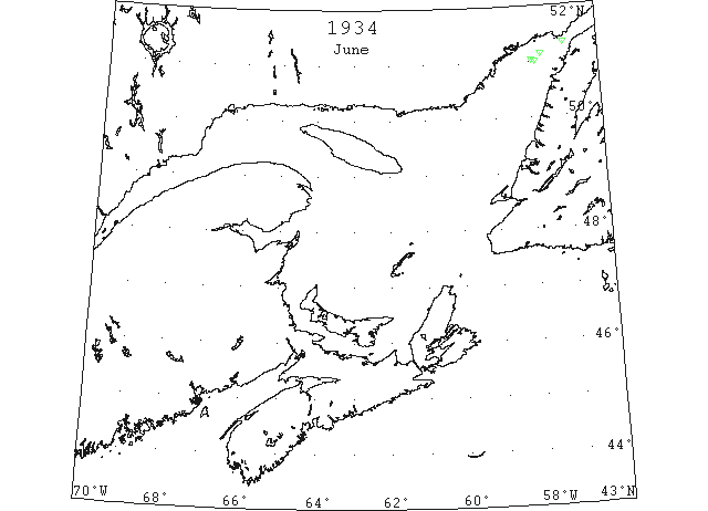
June 18 51°02’N 57°56’W Growler (IIP p46 #1656)
51°09’N 57°40’W 2 growlers (IIP p46 #1657)
51°20’N 57°00’W Growler (IIP p46 #1658)
June18 First Westbound steamer through the strait of Belle Isle. (WBB)
July 8 51°00’N 57°50’W Berg (IIP p46 #1742)