1932 Season
Dec (beginning) Pilotage officer, Father Point: Ice starts making. (CIS IC0708_2)
Dec 5 Last eastbound steamer through the Strait of Belle Isle. (WBB)
Dec 7 CGS “Aranmore” arrived. Brought back buoys from North Cape to Summerside and Tormentine. (Pat 7 Dec p8 c3)
Dec 15 Last departure of the season from Quebec. (WBB)
Dec 16 CGS “Aranmore” has completed her work and left for Halifax to lay up for the winter. CGS “Brant” also preparing to lay up. SS “Hillsboro” will continue trips as long as possible. (Pat 16 Dec p8 c3)
Dec 23 The frost of Sunday night formed a thin coating of ice over the Humber Arm, but on Mon. it broke up and disappeared. (TWS, pg. 2, Col. 4)
Dec 23 J.A. Ward, Lightkeeper, Miscou Point, New Brunswick: Closing date. (CIS IC0756_2)
Dec 29 Car Ferry “Prince Edward Island” is now in Borden. It is planned to lay her up there for the winter. (Pat 29 Dec p8 c4)
Dec 30 The SS “Kyle” arrived from St. John’s Wed. She has been chartered to keep a channel open in the ice from here to Sandy Point. (TWS, pg. 1, Col. 2)
Ice has formed all over the Arm a couple of inches in depth. (TWS, pg. 2, Col. 3)
Dec 30 Ferry steamer “Hillsboro” making daily trips, although harbour (Charlottetown) is filling with lolly. However, if weather continues it may equal last year’s record, trips till January 15th. (Pat 30 Dec p5 c1)
Dec 30 Georgetown Harbour busy spot. (Pat 30 Dec p8 c4)
Jan 5 Georgetown Harbour free of ice. SS “Wayland” now loading potatoes. She will be the last potato boat to leave Georgetown. (Pat 5 Jan p2 c4)
Jan 13 Last year the Humber Arm froze over on 23rd Jan, but it was some days later before it was safe to cross over. (TWS, pg. 2, Col. 7)
Jan 14 Ferry steamer “Hillsboro” still making regular trips to Rocky Point. Tomorrow steamer will equal last year’s record. May break it if mild weather continues. (Pat 14 Jan p5 c1)
Jan 19 Steamer “Montcalm” leaving Souris East on Tuesday, January 19th to take mail to the Magdalene Islands. (Pat 16 Jan p12 c4)
Jan 20 The SS “Kyle” after spending 2 weeks here keeping the ice channel open to Sandy Point completed her service and left for St. John’s on Tue. (TWS, pg. 2, Col. 5)
Jan 20 With one exception, this year is the latest SS “Hillsboro” has continued to run. In 1892, she ran to Southport until February 4th. (Pat 20 Jan p8 c3)
Jan 22 Rocky Point ferry ran until January 22nd. Since Friday crossing by ice boat. Thought by today, ice will be strong enough for pedestrian travel. (Pat 26 Jan p8 c3)
Jan 23 Open air rinks on Island operating under difficulties because of mild weather. (Pat 23 Jan p5 c1)
Jan 29 Montreal: The St. Lawrence River ship channel to the sea was frozen today after remaining open farther into the winter than any year on record. Records have been kept for 55 years and the latest date on which a freeze up occurred prior to this year was on January 5. A blockade was formed at the entrance of Lake St. Peter yesterday. Today an ice breaker was at work keeping the channel open there, and if the ice does not become too thick it will continue operations. While ocean vessels have not made use of the channel for over a month lesser craft have been operating. (HH 30/01/1932 p19#8)
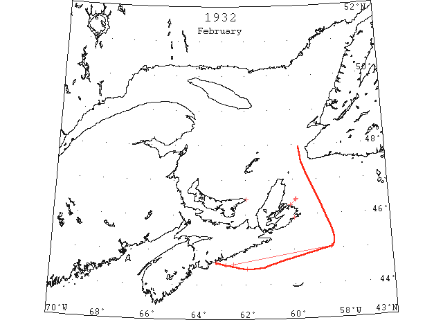
Feb 1 Lightkeeper, East Point, PEI: Ice formed in vicinity. (CIS IC0993)
Feb 9 The Canadian Government ice-breaker “Montcalm” is scheduled to leave North Sydney on February 15th for the Magdalen Islands. The “Montcalm” is to return through the ice fields to North Sydney with mails, etc., as may be required. (HH 09/02/1932 p13#2)
Feb 17 Sydney: Drift ice has begun to make its appearance and from Flat Point as far as the eye can see there is an abundance of it lying in every direction. The ice is of a light variety and consequently little difficulty is experienced getting through it. It’s appearance is much earlier than usual this year, having in past winters begun to show up along the coast during the early part of March. It appeared with dramatic suddenness this year. Two days ago there was not a sign to be seen, yet hardly 48 hours later the open water was completely covered. The CGS “Montcalm,” which left here Tuesday for Magdalens reached its destination today, having experienced some difficulty in bucking the heavy slob ice. (HH 18/02/1932 p3)
Feb 22 SS “Blankaholm” 44°35’N 62°30’W encountered young ice and slob, becoming thicker before ceasing in 45°03’N 58°30’W. (HB #2225 Apr 27)
Feb 24 Drift ice has begun to make and appearance and from Flat Point as far as the eye can see there is an abundance of it lying in every direction. Such was the information given to the press last week by Vincent Mullins, Sydney agent of the department of marine, who appraised of existing conditions by marines plying the Atlantic lanes. The ice it is said, is of a light variety, and consequently little difficulty is experienced in getting through it. Its appearance is much earlier then usual this year, having in past winters begun to show up along the coast during the early part of March. It appeared with dramatic suddenness this year. 2 days before there was not a sign to be seen, yet hardly 48 hours later the open water was completely covered. The C.G.S. “Montcalm” which left here for Magdalenes reached its destination Wed., having experienced some difficulty in bucking the heavy slob ice. (TWS 2 Mar pg. 1, Col. 7)
Feb 25 SS “Drottingholm” between 44°33’N 60°50’W [more likely 62°50’W as she was going E]and 44°27’N 61°57’W passed field ice with many growlers. (NYMR)
Feb 29 Incoming ocean liners and coast-wise crafts at Halifax over the week-end reported a large patch of heavy ice 15 miles off Halifax. Experienced navigators said these reports were unusual for so early in the year. Captain Frank Palmer of the Gloucester fishing schooner, “Elk,” forced in harbor for shelter said that the ice extended for about 20 miles and much of it was heavy ice. Outward bound from Halifax to Louisburg, the Danish freighter “Orania” ran into the ice when only a few hours from port, about noon on Saturday and returned to port in the evening after Captain Anderson had been advised by wireless that ice was blocking Louisburg harbor and he would not be able to enter. (HH 19/02/1932 p15#8)
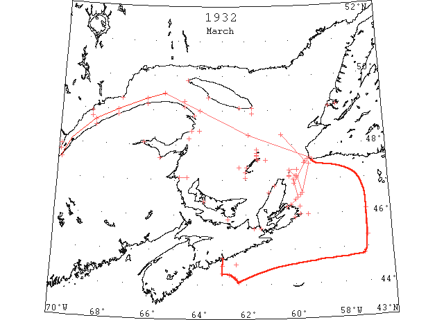
Mar 1 Pilotage officer, Father Point: River clear of ice. (CIS IC0707)
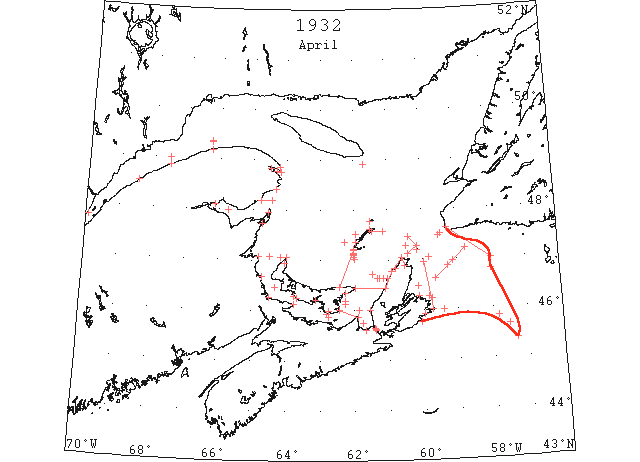
Mar 1 Fame Point, yesterday, open ice. Heath Point, ice all around both in shore and outside. Grosse Isle, heavy close packed ice as far as can be seen. Old Harry, open ice everywhere. Amherst Island, ~ 3 or 4 miles off shore. Etang du Nord, open ice in all directions. Pleasant Bay, full of slob ice and some shore ice. St. Pauls Island,, Scatari, Flat Point, all heavy close packed ice. Gut of Canso, open ice. Cape Ray, no ice in sight. (RG42 Vol.371)
Mar 2 Louisburg, CGS “Montcalm” left port on Saturday and assisted the collier “Watuka” to port. The “Watuka” had been caught in the ice since Friday morning. The steamer “Caribou” sailed for Newfoundland on Monday evening. The “Caribou” was compelled to come to Louisburg on account of North Sydney being blocked by ice. (HH 03/03/1932 p13#4)
Mar 3 L’Islet, very little ice. Cape Salmon and Cape Ray no ice in sight. Father Point, packed ice everywhere. Bersimis, light close packed ice distant. West Point, heavy close packed ice everywhere. Heath Point, light open ice in shore. Pleasant Bay, full of close packed ice. [RG42 Vol.371]
Mar 4 Cape Salmon and Cape Ray no ice in sight. Father Point, packed ice everywhere. Bersimis, heavy close packed ice distant. Point des Monts, heavy close packed ice. West Point, light open ice in shore. Heath point, heavy close packed ice. Falt Point and Scatari, heavy close packed ice in shore. (RG42 Vol.371)
Mar 5 Cape Salmon, very little ice. Father Point, packed ice everywhere. Fame point, heavy open ice everywhere. West Point and point Tupper, light open ice in shore. Cape Ray and St. Pauls Island, no ice in sight. Scatari and Flat Point, heavy close packed ice in shore. (RG42 Vol.371)
Mar 6 “Cliffwood” considerable broken ice, no lat., 62°43’W. (IIP p33#56h)
Mar 6 “Ausonia” field ice 44°11’N 62°28’W and cleared it 44°17’N 62°43’W, ice extended about 5 miles each side of track. (IIP p33#56i&j)
Mar 7 Cape Salmon, heavy close packed ice. Father Point, packed ice everywhere. Bersimis, Point des Monts, Cape Ray, all no ice in sight. Pleasant Bay, open ice. Fame Point, heavy open ice everywhere. West Point, light close packed ice distant. Heath Point, heavy close packed ice in shore. Point Tupper, light close packed ice everywhere. Scatari and Flat point, light close packed ice everywhere. St Paul Island, light open ice in shore. (RG42 Vol.371)
Mar 7 Warning that ice is getting rotten in the rivers. (Pat 7 Mar p5 c1)
Mar 8 “General Greene” growler and broken field ice extending N and S as far as could be seen 44°32N 63°00’W. (IIP p32#32)
Mar 8 “General Greene” light field ice 44°35’N 62°25’W. (IIP p32#33)
Mar 8 Cape Salmon, light open ice distant. Father Point, packed ice everywhere. Bersimis, Point des Monts, Cap d’Espoir, South Point, Cape Ray, all no ice in sight. Matane, heavy open ice distant. Martin River, heavy open ice everywhere. West Point, heavy open ice in shore. Heath Point, heavy close packed ice everywhere. Westward no ice in sight. Point Escuminac, NB, heavy close packed ice everywhere. Scatari and Flat Point light close packed ice everywhere. St. Pauls Island, light close packed ice everywhere. Slob ice SW. (RG42 Vol.371)
Mar 9 Latest reports from out the bay state that the ice has broken away into Blomidon Brook, while on the other side it has gone well up Middle Arm. (TWS, pg. 2, Col. 3)
Mar 9 Chebukto Head: large area field ice 44°03’N 62°19’W and 44°17’N 62°43’W. (IIP p33#56k&l)
Mar 9 L’Islet, river partly covered with ice. Cape Salmon, light open ice distant. Father Point, packed ice everywhere. Bersimis, light close packed ice distant. Matane, light open ice everywhere. Point des Monts, Cap d’Espoir, Point Tupper, Cape Ray, all no ice in sight. West Point, heavy close packed ice. South Point, ice moving to W. Heath point, heavy close packed ice everywhere eastward. Point Escuminac, NB, heavy close packed ice everywhere. Scatari and Flat point, light open ice everywhere. St. Paul Island, slob ice S and E. (RG42 Vol.371)
Mar 9 Report from ferry steamer plying between Sydney and Port aux Basques, heavy rapid ice from 25 miles off Flat Point. (RG42 Vol.371)
Mar 10 L’Islet, light open ice. Cape Salmon, open ice distant. Father point, packed ice everywhere. Bersimis, light close packed ice distant. Matane, heavy close packed ice everywhere. Pointe des Monts, Cap d’Espoir, Cape Ray all no ice in sight. Martin River, heavy open ice everywhere. Pleasant Bay, clear of ice. Cap des Rosiers, light open ice in shore. West Point, light open ice stationary. Heath Point and Point Escuminac, heavy close packed ice everywhere. Scatari, Flat Point and St. Paul Island, light open ice everywhere. (RG42 Vol.371)
Mar 11 Cape Salmon, light open ice distant. Father Point, packed ice everywhere. Bersimis, Pointe des Monts, Cap d’Espoir, Pleasant Bay, Point Maquereau, Cape Ray, Point Tupper, all no ice in sight. Matane and Martin River, heavy close packed ice everywhere. Fame Point, heavy open ice everywhere. Cap des Rosiers, light open ice everywhere. West Point, light close packed ice stationary. SW Point and Heath Point, heavy close packed ice everywhere. Point Escuminac, heavy close packed ice everywhere. Scatari, Flat point and St. Paul Island, light open ice everywhere. (RG42 Vol.371)
Mar 12 L’Islet, light open ice. Cape Salmon, heavy open ice everywhere. Father Point, packed ice everywhere. Bersimis, Pointe des Monts, West Point, Pleasant Bay, Cape Ray, Point Tupper, Flat Point, all no ice in sight. Matane, Martin River, Point Escuminac, heavy close packed ice everywhere. Grosse Isle, close packed ice. Fame point, heavy open ice everywhere. Cap des Rosiers, light open ice distant, SE. Cap d’Espoir, light close packed ice distant. Heath Point, heavy open ice distant southward. Scatari, heavy open ice everywhere. St. Paul Island, light open ice in shore. (RG42 Vol.371)
Mar 12 Newfoundland steamer reports heavy open ice 48 miles off Channel Head to within 19 miles off Low Point. (RG42 Vol.371)
Mar 14 L’Islet, open ice. Cape Salmon, Cap d’Espoir, Point Maquereau, Bersimis, Pointe des Monts, West Point, South Point, Heath Point, Pleasant Bay, Cape Ray, Flat Point, all no ice in sight. Matane, heavy close packed ice everywhere, Martin River, Fame Point, Cap des Rosiers, heavy open ice everywhere. Point Escuminac heavy close packed ice everywhere. Grosse Isle, ~ 5 miles of open ice. St. Paul Island and Point Tupper light open ice everywhere. Scatari, heavy open ice distant N and E. (RG42 Vol.371)
Mar 15 L’Islet and Cape Salmon, light open ice. Father Point, packed ice in shore. Bersimis, Point des Monts, Pleasant Bay, Cap d’Espoir, West Point, South Point, Heath Point, Cape Ray, Flat Point, all no ice in sight. Matane and Martin River, heavy close packed ice everywhere. Grosse Isle, ~ 6 miles of open ice. Fame Point, heavy open ice distant. Cap des Rosiers and Point Maquereau, light open ice distant. Point Escuminac, heavy close packed ice everywhere. Point Tupper, light close packed ice everywhere northward and southward no ice in sight. Scatari, light open ice distant N and E. St. Pauls Island, light close packed ice everywhere. (RG42 Vol.371)
Mar 16 L’Islet, open ice. Father Point, packed ice everywhere. Bersimis, Pointe des Monts, Pleasant Bay, Cap d’Espoir, Cape Ray, Flat Point, all no ice in sight. Matane, ice moving NE. Martin River, heavy close packed ice everywhere. Grosse Isle, close packed ice as far as can be seen. Fame Point, heavy open ice everywhere. Cap des Rosiers, light open ice distant. Point Maquereau, light open ice distant. West Point, ice moving S. Point Escuminac, heavy close packed ice everywhere. Point Tupper, light open ice in shore. Scatari and St. Pauls Island light close packed ice everywhere. (RG42 Vol.371)
Mar 16 Ferry steamer plying between Newfoundland and Sydney, heavy open ice 40 miles off port aux Basques to within 30 miles off Low point. (RG42 Vol.371)
Mar 16 Car ferry delayed by ice in Northumberland Strait. (Pat 16 Mar p8 c4)
Mar 17 L’Islet, open ice. Cape Salmon, considerable ice. Father Point, packed ice everywhere. Bersemis, Pointe des Monts, Pleasant Bay, Cap d’Espoir, South Point, Heath Point, Cape Ray, Point Tupper, Flat Point, all no ice in sight. Matane, ice moving NE. Martin River, heavy close packed ice everywhere. Grosse Isle, open ice. Fame point, heavy open ice everywhere. Cap des Rosiers, light open ice distant. Point Maquereau, light close packed ice distant stationary. West point, light close packed ice in shore. Point Escuminac, heavy close packed ice everywhere. Scatari, light open ice everywhere. St. Paul Island, light close packed ice everywhere. (RG42 Vol.371)
Mar 18 L’Islet, Bersimis, Pointe des Monts, Cap d’Espoir, Pleasant Bay, Point Maquereau, Cape Ray, Point Tupper, all no ice in sight. Cape Salmon, heavy ice distant. Father Point, packed ice in shore. Martin River and Fame Point heavy open ice everywhere. Grosse Isle, close packed ice. Old Harry, open ice distant. Cap des Rosiers, light open ice distant. West point, heavy open ice everywhere. Point Escuminac, heavy close packed ice everywhere. Scatari and St. Paul Island, light close packed ice everywhere. Flat Point, light open ice everywhere. (RG42 Vol.371)
Mar 19 L’Islet, Pointe des Monts, Pleasant Bay, Point Maquereau, South Point, Heath point, Cape Ray, Point Tupper, all no ice in sight. Cape Salmon, heavy ice distant. Father Point, packed ice in shore. Matane and Martin River, heavy open ice everywhere. Grosse Isle, close packed ice. Fame point, heavy open ice distant. Cap des Rosiers, light open ice distant. West Point, heavy open ice stationary. Point Escuminac, close packed ice everywhere. Scatari, Flat Point and St. Pauls Island, light open ice everywhere. (RG42 Vol.371)
Mar 19 Newfoundland steamer experienced 20 miles of heavy loose ice off Flat Point. (RG42 Vol.371)
Mar 21 L’Islet, open ice. Cape Salmon, light open ice distant. Father Point, packed ice everywhere. Bersimis, Pointe des Monts, Pleasant Bay, Cap d’Espoir, West point, South Point, Heath Point, Scatari, Flat Point, all no ice in sight. Matane, ice moving NE. Martin River, heavy close packed ice everywhere. Old Harry, open ice distant. Grosse Isle, close packed ice. Cap des Rosiers, light open ice everywhere. Point Escuminac, heavy close packed ice everywhere. Point Tupper and St, Pauls Island, light open ice in shore. (RG42 Vol.371)
Mar 22 Cape Salmon, packed ice everywhere. Father Point, light packed ice everywhere. Bersimis, Pointe des Monts, Pleasant Bay, Cap d’Espoir, Point Maquereau, West point, South Point, Heath Point, Scatari, Flat Point, all no ice in sight. Matane, ice moving NE. Martin River, heavy close packed ice distant. Old Harry, ice distant. Grosse Isle, open ice. Fame point, heavy open ice everywhere. Cap des Rosiers, light open ice everywhere. Point Escuminac, heavy close packed ice everywhere. St. Paul Island, heavy close packed ice everywhere. (RG42 Vol.371)
Mar 22 Continued heavy ice in Northumberland Strait. (Pat 22 Mar p8 c3)
Mar 23 “General Greene” heavy slab ice 45°20’N 57°00’W to 46°06’N 57°00’W. (IIP p33#47)
Mar 23 L’Islet, open ice. Cape Salmon, Bersimis, Pointe des Monts, Scatari, Flat Point, all no ice in sight. Father Point, packed ice everywhere. Matane, close packed ice distant. Martin River, heavy close packed ice distant. Pleasant Bay and Grosse Isle, open ice. Old Harry, open ice distant. Cap des Rosiers, light open ice stationary. Cap d’Espoir, light close packed ice stationary. Point Maquereau, light open ice distant. Point Escuminac, heavy close packed ice stationary. Open water distant. Cape Ray, heavy open ice distant. Point Tupper, light open ice everywhere. St. Paul Island, heavy close packed ice everywhere. (RG42 Vol.371)
Mar 23 Quebec, – Ice conditions in the Gulf of St. Lawrence are most favorable for an early opening of navigation, despite the contrary weather experienced during the past few days. There is a little heavy ice in the path of steamers coming through Cabot Straits, according to ice-breaker “Montcalm” returned to Sydney, NS, after patrolling the Gulf for several days. In describing conditions on the north and west side of Cape Breton and the Magdalen Islands, the path steamers bound for Quebec and Montreal will use, Captain Hearn told the Signal Service ‘there was scarcely enough ice in it to mix a cocktail.’ (HH 24/03/1932 p11#7)
Mar 24 “General Greene” large area field ice 44°50’N 57°10’W. (IIP p33#48)
Mar 24 L’Islet, Bersimis, Pointe des Monts, Point Maquereau, Cap d’Espoir, West Point, South Point, Heath point, Scatari, Flat Point, all no ice in sight. Cape Salmon, ice distant. Father Point, light packed ice everywhere. Matane, heavy close packed ice everywhere. Pleasant Bay, some slob ice. Old Harry, open ice distant. Grosse Isle, heavy close packed ice. Fame Point and Cap des Rosiers, light open ice everywhere. Point Escuminac, heavy close packed ice stationary. Cape Ray, heavy open ice everywhere. Point Tupper, light open ice everywhere. (RG42 Vol.371)
Mar 24 Newfoundland ferry steamer “Caribou” ran into heavy loose ice 10 miles off Port aux Basques. Then left it 30 miles off Low point where it was heavy packed. (RG42 Vol.371)
Mar 25 Yesterday’s ice races (horses) at Summerside were very largely attended. (Pat 26 Mar p3 c4)
Mar 26 L’Islet, light open ice. Cape Salmon, ice distant. Father Point, packed ice distant. Matane, heavy open ice in shore. Pointe des Monts, West Point, Heath Point, South Point, Scatari, Flat Point, all no ice in sight. Martin River, heavy open ice everywhere. Pleasant Bay, open ice. Old Harry, ice distant. Grosse Isle, heavy open ice. Fame point and Cap des Rosiers, light open ice everywhere. Point Escuminac, heavy close packed ice in shore. Cape Ray, heavy open ice stationary. St Pauls Island, heavy close packed ice. (RG42 Vol.371)
Mar 29 L’Islet, Cape Salmon, Bersimis, Pointe des Monts, West Point, Flat Point, Scatari, all no ice in sight. Matane, ice moving to SE. Martin River, heavy open ice inshore. Fame Point, light open ice everywhere. Cap des Rosiers, heavy close packed ice everywhere. Cap d’Espoir, light close packed ice in shore. Point Escuminac, heavy open ice distant, heavy close packed ice in shore. Grosse Isle, ice distant. Old Harry, Amherst Island, close packed ice. Pleasant Bay, some broken ice. St. Pauls Island, heavy close packed ice E and S. Point Tupper, close packed ice distant. Cape Ray, heavy open ice distant. (RG42 Vol.371)
Mar 30 Ice conditions in the Gulf- Montreal, March 23- Ice conditions in the Gulf of St. Lawrence were very satisfactory according to a survey made between March 17 and today by the C.G.S. “Montcalm”. Little heavy ice was reported through the Cabot Straits. In the narrowest part of the Straits between St. Paul Island, Cape Breton, and Cape Ray, NF, the “Montcalm” reported open water from a point 18 miles southeast of St. Paul to about 4 miles off Cape Ray. Strings of ice and slob with some leads of open water were prevalent in the main section of the Gulf. From St. Paul Island to the southeast and as far as could be seen from the bridge of the “Montcalm” heavy broken ice was visible. There was also a considerable amount of heavy ice on the north and west side of Cape Breton as well as north and west of the Magdalene Islands but it did not have much resistance, Capt. Hearn of the “Montcalm” reported to the Dominion Signal Service. (TWS, pg. 1, Col. 2)
Mar 30 The “Portia” had a very good trip up the coast this time. Although lots of ice was encountered, it was not stormy. Ice is packed close in on land now. It shifts off a little at times, and the men folks are enabled to get a few sea birds. The “Caribou” has been delayed on her trips this week by being stuck in the [ice?]. And it must be some ice that can keep back the good ship “Caribou” very long (Channel-Port aux Basques). (TWS, pg. 1, Col. 5)
Mar 30 The people of Lark Harbor and vicinity secured 60 white-coat seals on Sat. The ice was packed tight to land. (TWS, pg. 2, Col. 3)
Mar 30 L’Islet, river covered with scattered ice. Cape Salmon, Father Point, Point Maquereau, Bersimis, Point des Monts, West Point, South Point, Heath Point, Flat Point, Scatari, New Carlisle, Paspebiac, all no ice in sight. Matane, ice moving NE. Martin River, heavy open ice everywhere. Fame Point, slob ice along shore extending ~ 1 mile off shore, beyond that clear water. Cap des Rosiers, ice moving SE. Cap d’Espoir, light close packed ice distant. Point Escuminac, heavy open ice everywhere. Grosse Ile, Old Harry, open ice distant. Amherst Island, open ice offshore. Pleasant Bay, considerable open ice. St. Paul Island, light open ice everywhere. Point Tupper, light open ice distant. Cape Ray, heavy open ice moving. Cheticamp, bay still frozen over. Dalhousie, NB, river full of ice. Bathurst, harbour and bay still frozen over. (RG42 Vol.371)
Mar 31 L’Islet, open ice. Cape Salmon, Bersimis, Point des Monts, Pleasant Bay, Cap d’Espoir, West Point, South West Point, South Point, Heath Point, Scatari, Flat Point, all no ice in sight. Father Point, light open ice in shore. Matane, ice moving N. Amherst Island, open ice distant. Old Harry and Grosse Isle, open ice. Fame Point, light open ice distant. Cap des Rosiers, light open ice in shore. Point Maquereau, light open ice distant. Point Escuminac, heavy close packed ice distant, stationary. Cape Ray, heavy open ice distant, stationary. Point Tupper, light close packed ice everywhere. St. Paul Island, heavy close packed ice. (RG42 Vol.371)
Mar 31 North Sydney, “N B McLean,” from 8 p.m. position, steamed across Cabot Strait found very heavy ice and open water off Cape Breton coast; position 8 a.m. 22 miles east Cape North. From 40 miles northeast Bird Rock to 10 miles southwest of Cape Bay [Ray?] and from there to present position found close packed ice everywhere, except off Cape Bay. Owing to bad conditions between Quebec and Montreal it is not expected that the river will be navigable for at least 10 days. From Crane Island to 40 miles east same point, conditions good. From there to 40 miles northwest of Bird Rock, flood [sic] and light close packed ice and from there to Cape Bay heavy close packed ice. Cabot Strait full of heavy close packed broken ice. Navigation by way of Cabot Strait to Cape Bay not recommended at present. Magdalen Islands, clear; Grosse Isle, Old Harry, Amherst, Etang du Nord, heavy open ice, distant. St. Paul’s, clear; all points broken close packed ice everywhere in sight. Aspy Bay, clear; heavy close packed ice [distant?]. Flat Point, and Scateri, , clear, no ice in sight. Point Tupper, light southwest winds, clear, light close packed ice everywhere. Pleasant Bay, no ice in sight. North Sydney, no ice in sight. (HH 01/04/1932 p10#5,6)
Apr 1 J.A. Ward, Lightkeeper, Miscou Point, New Brunswick: Opening date. (CIS IC0756_3)
Apr 1 L’Islet, open ice. Cape Salmon, Father Point, Bersimis, Matane, Pointe des Monts, Fame point, Cap des Rosiers, West Point, Heath Point, Scatari, Flat Point, all no ice in sight. Pleasant Bay, some light ice in eastern end; rest of bay clear. Amherst Island, ~10 miles packed ice. Old Harry, close packed ice. Grosse Isle and Etang du Nord, open ice. Cap d’Espoir, light close packed ice stationary. Point Maquereau, light open ice distant. Point Escuminac, heavy close packed ice distant, stationary. Cape Ray, heavy open ice distant. Point Tupper, light close packed ice everywhere. St, Paul Island, heavy close packed ice. (RG42 Vol.371)
Apr 2 Ice is solid from inner Harbour Gaspe Village to Sandy Beach. From there on Bay covered with drift ice. (RG42 Vol.371)
Apr 2 L’Islet, light open ice. Cape Salmon, Bersimis, Pointe des Monts, Fame Point, Cap des Rosiers, West Point, South Point, Heath Point, Point Tupper, all no ice in sight. Matane and Martin River, heavy open ice everywhere. Pleasant Bay, some close packed ice in eastern end. Amherst Island, ~8 miles of open ice. Old Harry, open ice. Grosse Isle, open ice distant. Etang du Nord, heavy open ice. Cap d’Espoir, light close packed ice in shore. Point Maquereau, heavy close packed ice everywhere. Point Escuminac, heavy close packed ice stationary distant. Flat Point and St. Paul Island, light close packed ice everywhere. (RG42 Vol.371)
Apr 2 Ferry steamer “Caribou” reports 30 miles loose ice 50 miles from Flat Point. (RG42 Vol.371)
Apr 4 L’Islet, river covered with scattered ice. Cape Salmon, Father Point, Bersimis, Pointe des Monts, Pleasant Bay, Fame point, Cap des Rosiers, West Point, Heath point, Point Tupper, Scatari, Flat Point, all no ice in sight. Matane, heavy close packed ice in shore. Martin River, heavy open ice distant. Amherst Island, packed ice in shore. Old Harry, open ice everywhere, Grosse Isle, open ice distant. Etang du Nord, ~½ mile broken ice in shore. No ice SW and W. Open ice distant ~10 miles on N side. Cap d’Espoir, light close packed ice stationary. Point Maquereau, light open ice everywhere. Point Escuminac, heavy close packed ice in shore. Heavy open ice distant. Cape Ray, heavy open ice distant, stationary. (RG42 Vol.371)
Apr 5 L’Islet, light open ice distant. Cape Salmon, Father Point, Bersimis, Point des Monts, Pleasant Bay, Old Harry, Fame Point, Cap des Rosiers, Cap d’Espoir, West Point, South Point, Heath point, Cape Ray, Scatari, Flat Point, St. Paul Island, all no ice in sight. Matane, close packed ice distant. Martin River, open ice distant. Amherst Island, open ice 5 miles from shore. Grosse Isle, ~½ mile broken ice in shore. Etang du Nord, open ice. Point Maquereau, light open ice distant. Point Escuminac, heavy open ice. Shippigan, bay blocked with ice. Richebucto and Shediac, no open water in sight. Cape Tourmentine, light close packed ice in shore. Pictou, Strait reported clear of ice here. Port Hood, ice moving back in bay. Souris, no ice in sight; harbour clear of ice. Borden, PEI, heavy ice. Cheticamp, strong E wind drove off ice from this shore. Point Tupper, light open ice in shore. (RG42 Vol.371)
Apr 5 Twenty-six years ago last Friday, ice in Charlottetown Harbour was 16″ to 18″ thick, today it is only several inches thick though teams are still travelling on it. Steamer “Montcalm” will make a special trip to Magdalene Islands and will carry mail. Steam leaves North Sydney on Friday, 8th inst. (Pat 5 Apr p5 c2)
Apr 6 Trawler “Galena” field ice 45°23’N 57°20’W. (IIP p34#85)
Apr 6 All the ice is gone from the Harbor now (Channel- port aux Basques). (TWS, pg. 1, Col. 1)
Apr 6 L’Islet, Cape Salmon, Bersimis, Pointe des Monts, Pleasant Bay, Amherst Island, Fame Point, Cap des Rosiers, Cap d’Espoir, Point Maquereau, West Point, South Point, Heath Point, Cape Ray, Scatari, Flat Point, St. Paul Island, all no ice in sight. Father Point, Martin River and Matane, light open ice in shore. Etang du Nord, heavy open ice. Point Escuminac, heavy open ice in shore. Shippigan, bay blocked with ice. Richebucto, ice still solid. Port Hood, heavy body of ice N of island. Pictou, Strait reported clear of ice. Point Tupper, light close packed ice everywhere. Cheticamp, ice off shore. (RG42 Vol.371)
Apr 6 The Canadian ice-patrol steamer “N B McLean” this morning reported ice extending from Cape Ray to 47°00’N 58°00’W and to the southward from there. There were some strings of slob ice abeam of Heath Point. The SS “Tramontana” reported heavy, extensive ice field, 45°50’N 57°50’W. There was clear water down the Cape Breton coast a few days ago but north east gale now blowing is drifting ice towards coast. Cabot Strait is still blocked with heavy, close packed ice and this route is not recommended at present. Owing to bad conditions between Quebec and Montreal it is not expected the river will be navigable until about April 9. (HH 07/04/1932 p9#6)
Apr 7 First arrival of season at Quebec. (WBB)
Apr 7 L’Islet, Bersimis, Pointe des Monts, Pleasant Bay, Fame Point, Cap des Rosiers, Cap d’Espoir, West Point, South Point, Heath Point, Souris, Cape Ray, Scatari, Flat Point, all no ice in sight. Cape Salmon, close packed ice in shore. Amherst Island, open ice ~7 miles from shore. Etang du Nord, fairly open ice. Point Maquereau, light open ice distant; ice moving W in Bay de Chaleur. Pasbediac, clear of ice along shore but considerable ice around Gaspe. Point Escuminac, heavy open ice in shore. Shippigan, bay still solid. Richebucto, no water in sight. Shediac, ice still solid in harbour. Cape Tourmentine, heavy open ice. Pictou, drift ice in strait. Port Hood, ice distant. Cheticamp, ice distant. Point Tupper, light close packed ice distant northward. St. Paul Island, slob ice southward. (RG42 Vol.371)
Apr 8 L’Islet, Cape Salmon, Bersimis, Pointe des Monts, Fame Point, Cap des Rosiers, Cap d’Espoir, West Point, South Point, Heath Point, Port Hood, Souris, Cape Ray, Point Tupper, all no ice in sight. Father point, light scattered ice in shore. Matane, and Martin River, light open ice in shore. Pleasant Bay, considerable loose ice and close packed ice in western end of bay. Amherst Island, ~5 miles close packed ice. Old Harry, open ice. Grosse Isle, close packed ice everywhere. Etang du Nord, heavy open ice. Point Maquereau, light open ice distant and in Bay of Chaleur moving W. Port Daniel, bay free of ice. Chandler, bay clear of ice. Perce, no ice in sight. Charleton, bay clear of ice in 2 weeks. New Carlisle, no ice in bay. Point Escuminac, heavy open ice in shore. Shippigan, bay clear of ice. Richebucto, ice still solid. Shediac, no water in sight. Cape Tormentine, heavy open ice. Pictou, drift ice in Strait. Borden, light drift ice in Strait. Tignish, W side no ice from North Cape for ~6 miles to westward. E side ~ ½ mile of ice. Cheticamp, ice distant. Scatari and Flat Point, light open ice distant N and E. St. Paul Island, light close packed ice distant S and W. (RG42 Vol.371)
Apr 9 L’Islet to Point Maquereau, no ice. Pleasant Bay, narrow strip of slob ice. Amherst Island, close packed ice ~2 miles from shore. Old Harry, open ice. Grosse Isle, close packed ice. Etang du Nord, heavy open ice. West Point, no ice. Point Escuminac, heavy open ice in shore moving S. Shippigan, bay clear of ice. Richebucto, and Shediac, ice still solid. Cape Tormentine, heavy open ice. Dalhousie, bay clear of ice up to International Paper Co’s Wharf. Pictou, drift ice in Strait. Souris, no ice in sight. Borden, some light drift ice. Tignish, W side no ice from Cape North for ~6 to 8 miles westward. E side ~½ miles out. Cheticamp, ice overcast. Point Tupper, no ice in sight. Scatari, heavy close packed ice. St. Paul Island, heavy close packed ice S and SE. (RG42 Vol.371)
Apr 9 Steamer “Caribou” plying between Sydney and Newfoundland reports 25 miles loose ice in Gulf. (RG42 Vol.371)
Apr 9 Because of ice conditions between Quebec and Montreal, St. Lawrence River is not navigable until April 9th. Cabot Strait blocked with ice. Dense ice at 45°40’N and 57°33’W. (Pat 4 Apr p5 c5)
Apr 9 Quebec anticipating early opening of navigation on St. Lawrence River. This year, a local steamship company has advanced its passenger schedule 10 days, first vessel arriving April 9th. Mild weather throughout winter has prevented river water free freezing to any depth and channel was kept open from Montreal to the sea practically all season. (Pat 2 Mar p2 c4)
Apr 11 L’Islet to Point Maquereau, no ice. Pleasant Bay, considerable ice western part. Amherst Island, ice distant. Old Harry, open ice. Grosse Isle, close packed ice. Etang du Nord, heavy open ice. West Point, no ice. Shippigan, no ice outside; some ice in bay. Richebucto, and Shediac, ice still solid. Cape Tormentine, heavy open ice. Pictou, drift ice in sight. Port Hood, no ice in sight. Souris, no ice in sight. Borden, light drift ice. Tignish, W side from North Cape for ~6 miles to 8 miles westward no ice; E side ~½mile out. Cape Ray, no ice in sight. Cheticamp, ice distant. Point Tupper, no ice N of Hastings; light open ice southward. Scatari, heavy close packed ice. Flat Point, light open ice in shore. St. Paul Island, light close packed ice distant. (RG42 Vol.371)
Apr 12 L’Islet to Heath Point, no ice. Pleasant Bay, full of loose ice. Amherst Island, close packed ice in shore. Old Harry, close packed ice. Grosse Isle, open ice. Etang du Nord, heavy open ice. Shippigan, Gulf clear; some ice in bay. Richebucto, ice breaking up. Shediac, ice still solid. Cape Tormentine, heavy open ice. Pictou, Strait packed with heavy ice. Port Hood, no ice in sight in bay and ice between islands breaking up. Souris, no ice in sight. Borden, some light drift ice. Tignish, some broken ice in shore on W and E side. Cape Ray, no ice in sight. Cheticamp, Point Tupper and St. Pauls Island, no ice in sight. Scatari, heavy close packed ice. Flat point, light open ice everywhere. (RG42 Vol.371)
Apr 12 North Sydney, the Canadian Government ice patrol ship “N B McLean” reported this morning that there is no ice between Cape Ray and St. Paul’s Island but ships must be carefully navigated through a field of ice which extends from about 22 miles off St. Paul’s to Scatari in going to Heath Point. Ships sailing via Cape Race should shape their course to pass about 15 miles off St. Pierre and ships from Scatari to Cape Ray should keep relatively eastward before hauling for Cape Ray, in order to avoid strings of ice which fresh north, north-west winds are drifting southwards from Heath Point to Scatari. The SS “Madnhih?” reported on April 9 having met with a field of very light ice about 18 miles wide, and lying 20 miles south west of Scatari. Owing to bad conditions between Quebec and Montreal it is not expected that the river will be navigable until the end of the week, probably later. The ice still holds along the shores at various points. (HH 13/04/1932 p12#4)
Apr 13 The Humber Arm is again free of ice, the last having cleared on Mon., and motorboats were enabled to come in from various parts of the Bay to Curling. (TWS, pg. 2, Col. 1)
Apr 13 Heavy ice in St. Lawrence- Quebec April 5- The ice breaker “N.B. McLean” now carrying on patrol duty in the Gulf of St. Lawrence reported to the local agency of the Department of Marine that she was 10 miles off Cape Race[Ray?] Escorting the freighter “Silvia” through a field of floating ice. The Silvia is on her way up the St. Lawrence. The message from the “McLean” stated that there was heavy fog and poor visibility. It is expected that of the icebreaker can make any sort of headway through the pack ice, a lane will be made for the freighter and the latter will be able to reach the port of Quebec some time Thur. (TWS, pg. 3, Col. 3)
Apr 13 Lightkeeper, East Point, PEI: Spring breakup. (CIS IC0993_2)
Apr 13 L’Islet to Point Maquereau, no ice. Pleasant Bay, full of loose ice. Amherst Island, close packed ice. Old Harry, close packed ice everywhere. Grosse Isle, no ice in sight. Etang du Nord, heavy open ice distant. Anticosti Island, no ice in sight. Point Escuminac, heavy open ice distant. Shippigan, some ice in bay. Richebucto, ice breaking up. Shediac, ice still solid. Cape Tormentine, light open ice distant. Pictou, Strait packed with ice. Port Hood, no ice in sight. Souris, harbour packed with ice. Borden, Strait full of loose ice. Tignish, no ice on W side; some drift ice on E side. Cape Ray, no ice in sight. Cheticamp and St. Paul Island no ice in sight. (RG42 Vol.371)
Apr 14 Quebec to Point Maquereau, no ice. Pleasant Bay, full of light open ice. Amherst Island, close packed ice in shore. Old Harry, close packed ice. Grosse Isle, scattered ice distant. Etang du Nord, heavy open ice distant. West Point, no ice in sight. Point Escuminac, heavy open ice in shore. Shippigan, Gulf clear; apparently no ice at Paspediac, Miscou, Shippigan and Caraquet. Richebucto, harbour and channel open. Shediac, ice beginning to move out of Strait and harbour. Cape Tormentine, heavy open ice. Pictou, Strait packed with ice. Port Hood, no ice in sight along this coast. Souris, harbour full of ice. Borden, considerable ice on E side; none on W side. Cheticamp, scattered pieces of ice visible moving E. St. Paul Island, no ice in sight. (RG42 Vol.371)
Apr 14 Ferry steamer “Caribou” reports ~30 miles close packed broken ice 30 miles from Flat Point. (RG42 Vol.371)
Apr 15 Quebec to Heath Point, no ice. Pleasant Bay, full of light open ice. Amherst Island, close packed ice along shore. Old Harry, open ice as far as can be seen. Grosse Isle, scattered ice distant. Etang du Nord, heavy open ice. Shippigan, ice running out of bay. Richebucto, channel almost clear. Shediac, Strait and harbour clear of ice as far as Point Duchens Wharf. Cape Tormentine, light open ice everywhere. Port Hood, no ice in sight along this coast. Louisburg, ice conditions improving. Souris, harbour full of ice as far as can be seen. Borden, heavy drift ice. Tignish, considerable ice on E side; none on W side. Cheticamp, scattered ice moving E. Cape Ray, no ice in sight. St. Paul Island, edge of ice continues in SW and NW direction. (RG42 Vol.371)
Apr 16 Grindstone – Magdalen Islands surrounded on south side with close packed ice. Open ice distant on north side. (HH 16/04/1932 p20#1)
Apr 18 Steamer “Thyra” enroute Georgetown icebound 9 miles outside Panmure requiring icebreaker assistance. (RG42 Vol.371)
Apr 18 Gaspe Bay, open. Quebec to Heath Point, no ice. Cape Tormentine, heavy close packed ice. Louisburg, light scattered ice. Souris, harbour full of ice. Tignish, drift ice E and W. Borden, no ice in sight. (RG42 Vol.371)
Apr 18 Port Hood Island, the west coast of Cape Breton is now free of ice. The Strait of Canso of Cheticamp, Souris, and Pictou is all open water. (HH 18/04/1932 p11#7)
Apr 18 Georgetown – ferry running April 18th (Pat 7 Apr 1934 p7 c7)
Apr 19 Montreal to Anticosti, no ice. St. Pauls Island, no ice in sight. Richebucto, drifting ice. Shediac, ice still in harbour. Cape Tormentine, light open ice distant. Louisburg, scattered ice. Borden, no ice in sight. Souris, harbour full of ice. Tignish, considerable ice on E side only. (RG42 Vol.371)
Apr 19 C.G.S. “McLean”: In Gaspe Basin. Have broken ice from Sandy Point into docks. (RG42 Vol.371)
Apr 20 Montreal to Anticosti, no ice. St. Paul Island, small strip of loose ice stretching S to W of island. Shediac, ice in harbour and strait breaking up and moving out. Cape Tormentine, light open ice everywhere. Richebucto, harbour and river clear of ice. Port Hood, no ice in sight. Pictou, N side of Strait packed with ice. Souris, ice loosened up yesterday; some ice distant. Borden, considerable light drift ice. Tignish, considerable ice on E side only. Cheticamp and Cape Ray no ice in sight. (RG42 Vol.371)
Apr 21 Grosse Isle, no ice in sight. Old Harry, open ice distant. Amherst Island, open ice 6 miles from shore. Etang du Nord, open ice. Pleasant Bay, full of ice. Heath Point and Richebucto, no ice in sight. Cape Tormentine, light open ice distant. Souris, and Borden, no ice in sight. Tignish, heavy drift ice outside on E side only. Shediac, strait and harbour full of drifting ice. St. Paul Island, no ice in sight. (RG42 Vol.371)
Apr 22 Point Esuminac, heavy open ice in shore. Shippigan, no ice in sight in Miscou Bay and Shippigan. Richebucto, harbour and river clear of ice. Shediac, drifting ice in harbour and strait. Souris, Borden and Cheticamp, no ice in sight. Tignish, heavy drift ice on E side only. (RG42 Vol.371)
Apr 23 “Advised that icebreaker proceeding to assist “Coalby” in difficulties SW of Magdalens owing to this vessel not following clear route as advised.” (RG42 Vol.371)
Apr 25 North Sydney, there is a large body of ice on the north side of Prince Edward Island, extending to the Magdalen Islands and drifting rapidly toward the Cape Breton coast. Ships should not pass East Point, PEI, according to a wireless report received today from the Canadian ice-patrol ship “N B McLean”. There is ice in St. George’s Bay, and this too, is drifting toward the Cape Breton coast. The report stated the route by way of the Gut of Canso and East Point soon would be blocked with ice, and its use was not recommended. The east coast of Prince Edward Island is clear, and Souris and Georgetown harbors are open. (HH 26/04/1932 p14#3)
Apr 26 Norwegian steamer “Sydfold” from Norfolk to Charlottetown reports having drifted by heavy ice inside Indian Rock now in dangerous position (later went aground). Requesting icebreaking assistance. (RG42 Vol.371)
Apr 26 North Sydney, ships traveling between St. Pierre and Cape Ray, should keep a sharp lookout for strings and patches of drift ice, according to a wireless report from the Canadian ice-patrol ship “N B McLean.” The “McLean” reported a large body of ice between East Point, Prince Edward Island and the Magdalen Islands and extending to the west coast of Cape Breton. Patches were drifting around Cape North to east and south. There were strings and patches of ice 20 miles south east of St. Paul’s Island, drifting eastward. St. George’s Bay and the Gut of Canso had large bodies of drift ice. East Point was blocked and that route was not recommended. (HH 27/04/1932 p13#8)
Apr 27 Mulgrave, an oil tanker, the SS “Rideaulite” from Halifax for Quebec and Montreal, has been forced to return to port after a second attempt to batter her way through the heavy ice which blocks the northern entrance of the Strait of Canso. North Bay is reported to be packed with ice, while the Strait has the heaviest of the season. The southern entrance is free to Bear Island. A brisk wind should clear the situation. (HH 28/04/1932 p9#5)
Apr 28 Lightkeeper, East Point, PEI: Clear of ice. (CIS IC0993_3)
Apr 29 Word was received in Halifax yesterday that the patrol ship “N B McLean” escorted several vessels through the ice-fields, patrolling between Indian Rocks, PEI and Cape George, NS. She reported there was very little ice in the Northumberland Strait from Charlottetown to Cape Bear. From Cape Bear to Cape George there were some strings and patches. This course was easily navigable during daylight hours but ships were advised to be cautious in attempting it during darkness. Charlottetown harbor was open but the buoys have not been laid. There was a large body of ice extending up the west coast of Cape Breton to Cape North, some of which was drifting eastward around St. Paul’s Island and might cross the route from Cape Ray to Bird Rock. There was ice to the north and west of Bird Rock, the ships were advised to keep a sharp lookout in that vicinity. The Gut of Canso was open for navigation straight through to Charlottetown. There was ice along the west coast of Cape Breton but that route was considered navigable while the wind remained westerly. (HH 30/04/1932 p20#4)
Apr 29 An unusually early start has been made in the Nova Scotia coal trade to the St. Lawrence. Word received from Montreal yesterday said that already five ships have arrived in the river. (HH 30/04/1932 p20#2)
Apr 30 Grindstone – No ice in sight at Amherst Island, Etang du Nord and Hospital Cape. About half mile drift ice at Grosse Isle. (HH 30/04/1932 p20#2)
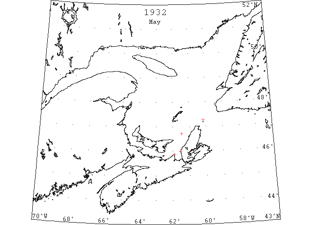
May 4 Mulgrave, The SS “Rideaulite” and SS “Labrador Trader,” forced to remain in port due to heavy ice, have left port, sailing northward. The conditions at the northern entrance have cleared to some extent. The Prince Edward and Magdalen Islands are reported to be clear of ice, with scattered ice at Cape George and Port Hood. With today’s southwest wind, the remaining ice in the Strait should move out shortly. (HH 05/05/1932 p14 #3)
May 10 Lightkeeper, SW Light, St. Pauls Island: Spring breakup. [latest in 10? year record] (CIS IC1007)
May 29 First Westbound steamer through the strait of Belle Isle. (WBB)