1930 Season
SS “Imogene” left St.John’s Apr 25 for Montreal, no mention of ice until the Gulf. (#805).
Capt. R. Geary, Marine Supt., Bowaters, Nfld: On the 19th January 1930, the SS “Corner Brook” while attempting to reach Corner Brook, in company with the SS “Kyle” a vessel with ice-breaking ability, jammed in drift ice off Cape St. George. Both these vessels were helpless and unable to move. Drifting northward in the ice they arrived off the entrance to the Bay of Islands 2 months later. A strong NE gale on 19th March opened up the ice sufficiently to enable them to break through the drift ice and enter the bay ice, through which they were able to slowly break their way into port. The “Corner Brook” was seriously damaged, the frames and plating on the ship’s side being set in by the pressure for as much as 10 inches. (CIS IC0736_7-IC0736_8)
Dec 2 Last eastbound steamer through the Strait of Belle Isle. (WBB)
Dec 4 Deer Lake is at present free of ice, owing to high winds and the changeable weather. The coldest temperature recorded to date was 18 degrees Fa. (TWS, p.2).
Dec 11 The SS “George L”. tried twice to cross from Summerside on Monday but was unable to negotiate a channel through the ice. (TWS, p.2).
Dec 18 There is very little ice in Deer Lake at present and only a strip of ice extending over the extreme head of the lake is yet fit for walking upon. (TWS, p.2).
Dec 23 Last departure of the season from Quebec. (WBB)
Dec 23 J.A. Ward, Lightkeeper, Miscou Point, New Brunswick: Closing date. (CIS IC0756_2)
Dec 24 C.G.S. ”Mikula” and SS “Odile” lying off Cape Salmon in heavy close packed ice. (RG42 Vol.371)
Dec 26 C.G.S. “Montcalm”: 8 a.m. 2 miles WNE from Red Island with “Boreas”. Ice close packed with occasional open leads. 6 p.m. about 2 miles E of Red Island Lightship, stopped in heavy close packed ice. C.G.S. “Mikula”: 8 a.m. abeam Bic in mid-channel. Southerly wind drifting ice from shore fast. We have to work these ships further E so as to get some ice north of them to keep them from getting pushed on N shore. ~ 4 p.m. Stopped since noon in broken ice on W edge of heavy pack. Ice S and E of us very heavy, unbroken sheets of rafted and batture ice. Tried a couple of cracks in it this morning and stopped after making about 3 lengths of ship. This extends as far A as we can see from crow’s nest. We are now with our 3 ships N 27 E mag. from Bic 8¾ miles. A good position to drift out with the pack. (RG42 Vol.371)
Dec 27 C.G.S. “Montcalm”: 8 a.m. about 7 miles E by S of Escoumains. Ice very close packed and waiting first opportunity to proceed. . C.G.S. “Mikula”: 5 a.m. Position N 35 E mag. from Bic. Drifted 12¾ miles. Ice conditions here about same as yesterday as far as we could see. (RG42 Vol.371)
Dec 28 C.G.S. “Mikula”: 8 a.m. 6 miles S by E Bersimis, ice close packed from shore to shore. (RG42 Vol.371)
Dec 30 C.G.S. “Mikula”: Approx. position 11 miles S 27° W mag. from Maniquagan Point. Ice in large sheets 3” thick and level. C.G.S. “Montcalm”: 8 a.m. about 4 miles ESE from Gulnare Shoal since daybreak. Made about ½ mile with “Boreas”. Ice close packed. (RG42 Vol.371)
Dec 31 Dept of Mar & Fish: C.G.S. “Mikula” abreast Trinity West; ice in large heavy sheets, open in places. C.G.S. “Montcalm” 6 miles S27E from Outside[Outardes] Point; ice rafted but small open leads ahead of us. “Gaspesia” off Seven Islands in ice and snow. (RG42 Vol.371)
Dec 31 Ottawa, battling their way down the Gulf of St. Lawrence, having made no more than 20 miles of their voyage since leaving Quebec on Christmas eve, the three trans-Atlantic freighters, “Lord Downshire” “Charterhulme” and “Odlle,” convoyed by the Canadian Government icebreaker “Mikula” were reported this morning to be off Trinity Bay. (HH 02/01/1930 p11#2)
Dec 31 Georgetown Harbour pilot put his boat up December 31st. Harbour still open, no cake ice to be seen. (Pat 9 Jan 1930 p 2 c2)
Dec (end) Pilotage officer, Father Point: Ice starts making. (CIS IC0708_2)
Jan 1 “Gaspesia” arrived at Havre St. Pierre. Went to about 3 miles from wharf in ice. This ice now strong enough to permit unloading. C.G.S. “Montcalm”: 3:45 p.m. 1 mile off Point des Monts at northerly end, heavy ice. C.G.S. “Mikula”: 3.45 p.m 1 miles off Point de Monts at northerly edge heavy ice with “Borea”. (RG42 Vol.371)
Jan 2 C.G.S. “Mikula”: 8 a.m. laying in shore ice at entrance to Seven Islands. C.G.S. “Montcalm”: 9 a.m. Approximately 3 miles off Egg Island in close packed ice with only few small open leads as far as can be seen now. Trying to go close to N shore and proceed to Seven Islands. “Gaspesia” stopped in thick ice 7 miles above Perroquet Island. (RG42 Vol.371)
Jan 2 On her last run to the Magdalen Islands the “Lovat” left Pictou on December 24, calling at Souris en route. Only two ports Grindstone and Amherst were visited on the island. The CGS “Stanley” was sent to help the “Lovat” at Grindstone to get through the ice, but her assistance was not required. On a previous trip the rail of the steamer was damaged by ice. (HH 02/01/1930 p11#3)
Jan 2 The ice breakers ”Mikula” and “Montcalm” on Dec. 30 were breaking a channel for the steamers “Charterhulme”, “Lord Downshire”, “Odile”, and “Boreas”. The three first named, headed by the “Mikula”, had reached the edge of the heavy close packed ice and the “Mikula” turned back to assist the “Montcalm” with the “Boreas”. The “Mikula’s” convoy was off Trinity Bay west, 10 miles east of Point des Monts. The “Montcalm” and “Boreas” were at Outardes Point ten miles below Bersimis. When the four steamers reach open water, the “Mikula” will continue with them as far as Sydney, Cape Breton. The steamer “Gaspesia” was waiting off Seven Islands for twenty-four hours on Dec. 30 in a heavy snowstorm. The “Charterhulme”, “Lord Downshire” and “Odile” were off Seven Islands on Jan.2. (NYMR, p.13, col.2).
Jan 3 C.G.S. “Montcalm”: 8 a.m. 5 miles S 60 E from Cawee[?] Island Light. Made 12 miles since daybreak. Ice heavy but more open as far as can be seen everywhere. (RG42 Vol.371)
Jan 4 C.G.S. “Montcalm”: 9 a.m. at Seven Islands; fresh NNW wind ice moved off shore. (RG42 Vol.371)
Jan 4 Dept. Mar & Fish: Anticosti: West Point, light open in shore; S.W. Point, light close packed everywhere; S. Point, heavy close packed everywhere; Heath point, close packed everywhere. Magdalen Islands: Grosse Isle, Grindstone and Old Harry about 7 miles of slob ice in shore; Etang du Nord, few scattered pieces in shore. (RG42 Vol.371)
Jan 7 C.G.S. “Montcalm”: 8 a.m. about 2 miles E of Carousel Island. Ice close packed, progress very poor. C.G.S. “Mikula”: 8 a.m. approximately 10 miles W of Havre St. Pierre, ice in heavy large sheets with big leads of open water and same continues as far as can be seen at present. (RG42 Vol.371)
Jan 7 Sydney, the Canadian Government ice breakers “Montcalm” and “Mikula” and the freighters “Lord Downshire” and “Charterhumle” are tonight still sought in the ice floes in the Gulf of St. Lawrence; the “Mikula” at the time the message was flashed was caught fast in a field of ice floes at North Point, Anticosti Island, about 220 miles from Sydney. She is standing by the freighter “Lord Downshire” and SS “Charterhumle.” The ice breaker “Montcalm” tonight is also still bucking the ice floes in the vicinity of Seven Islands, west of Anticosti Island and has under escort the steamers “Broeas” and “Udille.” (HH 08/01/1930 p3#4,5)
Jan 8 It was reported on Monday that there was some slob ice off Bay of Islands. (TWS, p.2).
Jan 8 The SS “Kyle” completed her charter with the A. N. D. Co. ice breaking on the Exploits on Monday, and we understand she will now proceed here under charter with the I. P. & P. Co. to do similar work on the Humber during the balance of this month. (TWS, p.2).
Jan 8 SS “Sagona” left here on Tuesday, New Year’s Eve, for North and took with her the key of shipping for the season. While here, the captain, John Gullage, officers, crew and ship showed their ability in cutting up ice as there was a jam of it wherever they had to call. (TWS, p.2).
Jan 8 The “Sagona” could not get to Lomond on her last trip going North. The freight was discharged on the ice about a mile and a half from the wharf and hauled in by horses. (TWS, p.2).
Jan 8 C.G.S. “Montcalm”: 8 a.m. 20 miles S 68° E from Carousel; ice little softer, making better progress. C.G.S. “Mikula”: Stopped in close packed ice at 1:30 a.m 12 miles S 60° E mag. from Heath Point. (RG42 Vol.371)
Jan 8 Dept. Mar & Fish: Fame Point, heavy open ice distant. Point des Monts, light open ice distant. West Point, Anticosti, heavy close packed ice moving NE. South West point, heavy close packed ice everywhere. (RG42 Vol.371)
Jan 9 C.G.S. “Montcalm”: 8 a.m. about 12 miles S of Pigou (36 miles E of Seven Islands). Owing to NW wind drifted towards SE last night in close packed ice. Expect to find ice thinner closer to N Shore but just now ice appears same condition as before. (RG42 Vol.371)
Jan 9 Freighter convoy reached Gulf from Quebec. Fourteen days breaking through St. Lawrence River ice. (Pat 9 Jan p 1 c7)
Jan 10 C.G.S. “Montcalm”: 8 a.m. 5 miles S 55° W from Magpie. Ice 3 to 4” thick and rafted in may places. Making slow progress. (RG42 Vol.371)
Jan 11 Lightkeeper, East Point, PEI: Ice formed in vicinity. (CIS IC0993)
Jan 11 C.G.S. “Mikula”: 8 a.m 5 miles S from Walrus Island in about 6” of ice and rafted at places as far as can be seen everywhere. Progress very poor this morning. “Gaspesia” same position and ice condition. (RG42 Vol.371)
Jan 12 C.G.S. “Montcalm”: 8 a.m. 50°01’N 62°40’W. Drifted about 12 miles [overnight?]. Made about a mile since daybreak. Ice same as last report, proceeding SE. (RG42 Vol.371)
Jan 12 Sydney, the Canadian government icebreaker “Mikula” sailed from there today in an effort to assist the Canadian government icebreaker “Montcalm” and the steamers “Boreas” and “O’Dile,” which have been caught in the Gulf of St. Lawrence ice barrier for the past three weeks. The “Montcalm” and the two steamers were making slow progress in their fight against the ice floes and with present ice conditions it will be impossible for them to reach this port before the middle of the week. (HH 13/01/1930 p3#7)
Jan 13 C.G.S. “Mikula”: Strings of slob ice sighted off St.Pauls, en route from Sydney. C.G.S. “Montcalm”: 8 a.m. 49°53’N 61°57’W sheet ice close packed. (RG42 Vol.371)
Jan 13 C.G.S. “Montcalm”: 4 p.m. 49°35’N 61°15’W since this morning made about 32 miles through heavy sheets and few open leads now steering between S and SE. (RG42 Vol.371)
Jan 13 Ice is fairly heavy but not giving car ferry much trouble. (Pat 13 Jan p 8 c4)
Jan 14 C.G.S. “Mikula”: 8 a.m. 49°30’N 61°11’W ice heavy. C.G.C. “Montcalm”: 8 a.m. 49°33’N 60°05’W ice 4 to 5 inches thick with occasional leads. “Saurel” left Quebec 4 a.m., 9.45 passed East Middle Ground Buoy, open ice. “Gaspeseia: at Seven Islands, no water in sight. (RG42 Vol.371)
Jan 14 Magdalene Islands air mail service begun for 3rd year. (Pat 14 Jan p 5 c7)
Jan 15 Report reaching us yesterday stated that heavy drift ice was in to within five miles of South Head, and that inside was local ice which filled the bay. (TWS, p.2).
Jan 15 C.G.S. “Montcalm”: 9 a.m. 49°20’N 61°07’W. Since daybreak made about 2 miles towards SE, ice about 6” with occasional open leads. (RG42 Vol.371)
Jan 16 C.G.S. “Montcalm”: 8 a.m. 49°10’N 60°50’W in close packed ice progress poor since day break made about 2 miles towards SSE. 4 p.m. 49°05’N 60°49’W in heavy close packed ice. “Montcalm” jammed since noon with “Boreas” and “Mikula” helping us now. (RG42 Vol.371)
Jan 17 C.G.S. “Montcalm”: 8 a.m. 49°01’N 60°35’W in very heavy close packed ice made about a mile since day break with “Boreas” following “Mikula” track. “Mikula” noon position about 48°44’N 60°07’W then finding ice more open and younger. (RG42 Vol.371)
Jan 18 C.G.S. “Mikula”: 8 a.m. 48°40’N 59°57’W. Got “Odile” and “Montcalm” close to “Boreas” this morning. Ice some softer and more open here. Expect to make better progress today. Noon, 48°34’N 59°54’W. Ice getting much softer and broken in pans. Making good progress with “Boreas” but “Montcalm” about 6 miles behind with “Odile”. 3 p.m. got ‘Boreas” to 48°20’N 59°58’W where ice soft and broken. (RG42 Vol.371)
Jan 19 C.G.S. “Mikula”: SE gale last night have swell through ice and broke it all in pass. Proceeding slowly without stopping to present time (10:50 a.m.) 48°31’N 60°02’W. Noon position 48°21’N 59°55’W. Ice all broken to slob here and looks as if close to water making fair progress. 4 p.m. 2 miles SE from NE end St. Pauls with SS “Boreas”. From first position encountered fields of thin broken ice with largely open water. (RG42 Vol.371)
Jan 20 Sydney, CB- Steamers “Boreas” and “Odile”, the last of the ice bound vessels in the Gulf of St. Lawrence, were freed by the Can. Govt. ice breakers “Mikula” and “Montcalm” and arrived here under their convoy. The “Boreas” has rudder damaged and both vessels are scarred by ice. (NYMR, p.11, col.1).
Jan 20 SS “Boreas”: Arrived North Sydney, thin ice from southeast bar towards Sydney. (RG42 Vol.371)
Jan 20 Dept of Mar & Fish: Cape Salmon, heavy close packed ice everywhere. Father Point, heavy close packed ice everywhere. Fame Point, heavy close packed ice everywhere. Bersimis, light open ice everywhere. Point des Monts, light open ice everywhere. West Point, Anticosti, heavy close packed ice. (RG42 Vol.371)
Jan 20 Sydney, with the arrival at an early hour this morning of the Canadian government icebreakers “Montcalm” and “Mikula,” having under escort the SS “Boreas,” and the SS “Odile”, a thrilling epic of heroism against the ice barriers and floes of the Gulf of St. Lawrence was successfully brought to a close. Tonight the crews of the two colliers are enjoying their first real sleep in forty-seven nights under the ice of the International Piers here. The steamers left Montreal on December 3, according to an interview here tonight with the captain of the “Boreas,” in an effort to force their way down the St. Lawrence before the ice would close up their passage to the open sea. From the first day, they left port the steamers were in one continual battle with snow storms, heavy ice floes and cold winds which changed continuously. They had practically given up all hope of reaching the open sea when the “Montcalm” arrived. Led by the “Montcalm” the two steamers made very little progress and were practically forced to be carried along with the ice. While in the ice barriers the rudder of the “Boreas” became damaged and this caused the crew considerable worry as it was practically impossible to steer the steamer owning to the heavy ice. The steamer also began to leak and the crew were forced to take the necessary steps to save it from sinking. Meanwhile, the “Mikula” was also dispatched to the assistance of the “Montcalm” and the two colliers and she set sail from North Sydney last Sunday. Forcing her way through the ice barriers the “Mikula” arrived on the scene and led by the two icebreakers, the colliers made one more desperate effort to reach the open sea. From Tuesday until Sunday afternoon the convoy of four steamers bucked and fought the ice barriers and it was at a late hour on Sunday afternoon when open water was reached in the vicinity of Ingonish. They made a short run from Ingonish to Sydney and arrived here shortly after midnight. Captain Mercer of the “Montcalm” in an interview here tonight stated that the ice conditions in the Gulf of St. Lawrence are abnormal and that the gulf is practically covered with one sheet of ice ranging from 14 to 16 inches deep. As soon as the “Mikula” is finished bunkering at North Sydney she will again leave for the Gulf of St. Lawrence on another mission of mercy. The SS “Gaspe,” north shore mailboat is at present caught in the ice in the vicinity and the “Mikula” will make an attempt to convoy her to Murray, thence to Quebec. (HH 21/01/1930 p3#7)
Jan 20 Shipping stopped at Georgetown. Harbour freezing up. (Pat 20 Jan p 5 c2)
Jan 21 Dept of Mar & Fish: Magdalen Is.: Grosse Isle, light open ice distant; Old Harry, light open ice distant; Amherst, close packed ice; Etang du Nord, close packed ice; Pleasant Bay, about 1 mile of packed ice in shore ice. Souris, light board ice; no ice in sight. (RG42 Vol.371)
Jan 21 C.G.S. “Mikula”: Expect to leave North Sydney noon tomorrow. Weather keeps cold here and young ice formed all over harbour this morning. Eastern edge of western pack S edge off Ingonish last midnight. Eastern edge extends across to Newfoundland. (RG42 Vol.371)
Jan 21 Dept of Mar & Fish. Telegram: Thick ice was broken in pans with slob all through it as far as we could see on Sunday. SE swell must have had hove nearly up to Bird Rock. (RG42 Vol.371)
Jan 22 C.G.S. “Mikula”: Departed Sydney, passing NE of St. Pauls sheet ice heavy and open in places. (RG42 Vol.371)
Jan 22 Dept of Mar & Fish: Magdalen Is.: All points except Old Harry, close packed ice; Old Harry, open ice distant; Pleasant Bay, about 1 mile of shore ice. Cape Salmon, light open ice. Father Point, heavy close packed ice. Fame Point, heavy close packed ice everywhere. Bersimis, close packed ice everywhere. Point des Monts, close packed ice distant. West Point, Anticosti, light open ice everywhere moving S. Cheticamp, ice blocked on this shore since Jan. 16th.. Souris, no report yet. (RG42 Vol.371)
Jan 23 C.G.S. “Mikula”: 8 a.m. 48°03’N 60°41’W (22 miles NE Bird Rock) working through heavy sheet ice. Ice too heavy W of us to make Bird Rock. Must look out for coal supply as we may have considerable trouble getting W from Heath Point. Noon, 48°18’N 60°15’W going through close packed sheet ice making fairly good progress. 4 p.m. 48°38’N 61°07’W had some very hard butting this afternoon but made good progress for the kind of ice we are in at present. (RG42 Vol.371)
Jan 23 Dept of Mar & Fish: Magdalen Is.: Grosse Isle, close packed ice; Old Harry, light open ice distant; Amherst, heavy close packed ice; Etang du Nord, heavy close packed ice; Pleasant Bay, about 1 mile shore ice. Cape Salmon, heavy open ice everywhere. Father Point, close packed ice. Fame Point, heavy close packed ice everywhere. Godbout to Portneuf, no water in sight. Portneuf to Escumains, ice about 1 mile off shore. Cheticamp, ice blocked in shore. Souris, no ice in sight. (RG42 Vol.371)
Jan 24 C.G.S. “Mikula”: Cleared heavy ice at 6:20 last night 10 miles S 75 E mag. From Heath Point. 7:35 a.m. 4 miles north of Table Head going through young ice that is formed between the heavy pack and the N side of Anticosti, making about 12 kts. at present.. (RG42 Vol.371)
Jan 24 Dept of Mar & Fish. Cape Salmon, very little ice. Father Point, heavy close packed ice. Fame Point, heavy open ice everywhere. Pointe des Monts, light close packed ice everywhere. West Point, Anticosti, heavy close packed ice moving SE. Cheticamp, ice blocked in shore. (RG42 Vol.371)
Jan 25 C.G.S. “Mikula”: 8 a.m. 50°03’N 64°54’W (14 nm NW West Point, Anticosti). Heavy close packed ice in all directions; making slow progress. (RG42 Vol.371)
Jan 25 Dept of Mar & Fish: Magdalen Is.: Grosse Isle, open ice; Old Harry, open ice; Amherst, close packed ice; Etang du Nord, open ice; Pleasant Bay, close packed ice distant. Cape Salmon, heavy open ice everywhere. Father Point, heavy close packed ice distant. Fame Point, heavy open ice everywhere. Pointe des Monts, light close packed ice everywhere. West Point, Anticosti, light open ice in shore. Cheticamp, ice still in shore. (RG42 Vol.371)
Jan 27 Dept of Mar & Fish: Magdalen Is.: Grosse Isle, close packed ice; Old Harry, open ice distant; Amherst, close packed ice; Etang du Nord, heavy close packed ice; Pleasant Bay, open ice distant. Cape Salmon, light open ice everywhere. Father Point, heavy close packed ice. Fame Point, heavy close packed ice everywhere. Pointe des Monts, light close packed ice distant. West Point, Anticosti, heavy close packed ice everywhere. Cheticamp, ice in shore. Souris, no drift ice in sight. (RG42 Vol.371)
Jan 28 8 a.m. stopped in broken ice about 4½ miles SSE from Escoumains. (RG42 Vol.371)
Jan 28 Dept of Mar & Fish: Magdalen Is.: Grosse Isle, light open ice; Old Harry, light open ice; Amherst, close packed ice; Etang du Nord, close packed ice; Pleasant Bay, about 1 mile off shore. Cape Salmon, heavy close packed ice everywhere. Father Point, packed ice distant. Fame Point, heavy open ice everywhere. Bersemis, light open ice everywhere. Pointe des Monts, light open ice everywhere. West Point, Anticosti, light open ice distant. (RG42 Vol.371)
Jan 29 The SS “Kyle” being unable to reach Bay of Islands on account of ice, is returning to St. John’s. (TWS, p.2).
Jan 29 The river ice in Codroy Valley is in great shape just now for horse-racing. (TWS, p.2).
Jan 29 Dept of Mar & Fish: Cape Salmon, little ice. Father Point, packed ice distant. Fame Point, heavy close packed ice everywhere. Bersemis, light close packed ice everywhere. Pointe des Monts, heavy close packed ice distant. West Point, Anticosti, heavy close packed ice moving S. Baie St. Paul, light broken and sheet ice. (RG42 Vol.371)
Jan 30 Dept of Mar & Fish: Father Point, heavy close packed ice everywhere. Fame Point, heavy close packed ice. Pointe des Monts, light open ice everywhere. West Point, Anticosti, heavy close packed ice. (RG42 Vol.371)
Jan 31 Dept of Mar & Fish: Father Point, packed ice distant. Fame Point, heavy open ice everywhere. Bersemis, heavy open ice distant. Pointe des Monts, light close packed ice everywhere. West Point, Anticosti, light open ice everywhere moving to the N. (RG42 Vol.371)
Jan 31 Saint John, the fate of the mystery plane, sighted Thursday morning among the floes in the Gulf of St. Lawrence off Miscou Island, Gloucester county, northeast most point of New Brunswick, was shrouded in uncertainty tonight after a rescue place of the Canadian Airways, carrying food and supplies failed to locate the craft on a three hour flight. It is feared that the machine, from which flares were shown at four o’clock Friday morning had either gone down among the ice or that it had been carried out to sea with its unknown pilot or occupants. The plane when it was first sighted was about five miles off shore and yesterday morning was still in approximately the same position although it is believed that it was floating at that time toward the southward or the Straits of Northumberland. (HH 01/02/1930 p1#3)
Feb 1 Dept of Mar & Fish: Cape Salmon, little ice. Father Point, heavy close packed ice. Fame Point, heavy close packed ice everywhere. Bersemis, little ice. Pointe des Monts, light close packed ice distant. West Point, Anticosti, light open ice in shore. (RG42 Vol.371)
Feb 3 Dept of Mar & Fish: Cape Salmon, no ice. Father Point, heavy close packed ice distant. Fame Point, heavy close packed ice everywhere. Bersemis, heavy open ice distant. Pointe des Monts, light open ice everywhere. West Point, Anticosti, heavy close packed ice everywhere. (RG42 Vol.371)
Feb 4 SS “Magdalen” disabled by heavy ice off Arichat. (NYMR)
Feb 4 Dept of Mar & Fish: Cape Salmon, heavy close packed ice everywhere. Father Point, heavy close packed ice distant. Fame Point, heavy open ice everywhere. Bersemis, heavy close packed ice everywhere. West Point, Anticosti, heavy close packed ice. (RG42 Vol.371)
Feb 5 The “Caribou” on her last two trips across Cabot Strait encountered considerable ice. On Saturday the ice was tight to Channel Head. As a result the ship was considerably delayed, bringing the trains over twenty hours late on arrival at Curling. (TWS, p.2).
Feb 5 In conversation with a representative of the Western Star on Monday, Mr. House of Aguathuna said that at one time last week the steamers “Kyle” and “Corner Brook” were only a few miles away from Port au Port light. Later in the week the steamers drifted north in the ice, and on Saturday were off Serpentine. The ice, said Mr. House, is of the heaviest kind and impossible for any steamer to penetrate. It is thought the Gulf is full, as after twenty-four hours gale from the south-east last week the ice moved only a mile from the shore. (TWS, p.2).
Feb 5 Dept of Mar & Fish: Cape Salmon, no ice. Father Point, close packed ice distant. Fame Point, heavy open ice everywhere. Bersemis, heavy open ice in shore. Pointe des Monts. light open ice distant. West Point, Anticosti, light open ice in shore moving to NW. (RG42 Vol.371)
Feb 6 Dept of Mar & Fish: Cape Salmon, heavy packed ice everywhere. Father Point, heavy close packed ice distant. Fame Point, heavy close packed ice everywhere. Bersemis, heavy close packed ice everywhere. Pointe des Monts, light open ice everywhere. West Point, Anticosti, heavy close packed ice. (RG42 Vol.371)
Feb 7 Dept of Mar & Fish: Cape Salmon, light open ice everywhere. Father Point, heavy close packed ice distant. Fame Point, heavy close packed ice everywhere. Bersemis, heavy open ice inshore. Pointe des Monts, light open distant. West Point, Anticosti, heavy close packed ice moving to SE. (RG42 Vol.371)
Feb 8 Dept of Mar & Fish: Cape Salmon, light open ice everywhere. Father Point, heavy close packed ice, distant. Fame Point, heavy open ice everywhere. Bersemis, light close packed ice everywhere. Pointe des Monts, open ice distant. West Point, Anticosti, heavy close packed ice moving SE. (RG42 Vol.371)
Feb 8 The steamer “Corner Brook” had been caught in heavy ice off the Newfoundland coast. The CGS ice-breaker, “Stanley” has been sent to her assistance. Bound from a United States port the “Corner Brook” for several days had been attempting to reach Corner Brook. (HH 08/02/1930 p21#6)
Feb 10 Cape Race: Heavy field ice 45°29’N 57°30’W 45°15’N 58°00W. (IIP p9#144)
Feb 10 Dept of Mar & Fish: Father Point, close packed ice, distant. Fame Point, heavy open ice everywhere. Bersemis, light close packed ice everywhere. Pointe des Monts, light close packed ice, distant. West Point, Anticosti, light open ice in shore, moving to the N. (RG42 Vol.371)
Feb 11 Dept of Mar & Fish: Cape Salmon, little ice. Father Point, close packed ice, distant. Fame Point, heavy close packed ice everywhere. Bersemis, light close packed ice everywhere. Pointe des Monts. Light open ice, distant. West Point, Anticosti, open ice in shore. (RG42 Vol.371)
Feb 12 SS “Caribou” encountered much ice crossing Cabot Strait on her last Wednesday’s trip and as a result did not reach Port aux Basques until Friday night. (TWS, p.2).
Feb 12 The SS “Kyle”, held in the grip of the ice king in the Gulf of St. Lawrence the past three weeks, has been chartered to the Union Trading Co. for the approaching voyage. (TWS, p.2).
Feb 12 Dept of Mar & Fish: Cape Salmon, light open ice. Father Point, heavy close packed ice, distant. Fame Point, heavy close packed ice everywhere. Bersemis, open ice in shore. Pointe des Monts, no ice in sight. West Point, Anticosti, close packed ice moving SE. (RG42 Vol.371)
Feb 14 Dept of Mar & Fish: Cape Salmon, no ice. Father Point, heavy close packed ice, distant. Bersemis, no ice in sight. Pointe des Monts, no ice in sight. West Point, Anticosti, light open ice in shore. (RG42 Vol.371)
Feb 14 Unable to reach Arichat on account of heavy ice which stretched for 10 miles, the motor vessel “Ile Madame,” returned to Halifax yesterday. The assistance of the CGS “Stanley” was secured to break the ice and the “Ile Madame” left again last night and is to follow in the wake of the ice breaker. While the “Ile Madame” lay “frozen out” off Arichat the steamer “Magdalen” was frozen in. The “Stanley” will free the “Magdalen” which is to come here for minor repairs after which she will commence operating from Halifax to shore ports, sailing as far as St. Peters when conditions permit. (HH 14/02/1930 p11#4)
Feb 15 Dept of Mar & Fish: Cape Salmon, little ice distant. Father Point, heavy close packed ice, distant. Fame Point, heavy close packed ice everywhere. Bersemis, no ice. Pointe de Monts, no ice. West point, Anticosti, heavy close packed ice moving to S. (RG42 Vol.371)
Feb 17 Dept of Mar & Fish: Cape Salmon, little ice distant. Father Point, close packed ice distant. Fame Point, heavy close packed ice everywhere. Bersemis, light open ice everywhere. Pointe de Monts, light open ice everywhere. West Point, Anticosti, close packed ice moving SE. (RG42 Vol.371)
Feb 18 Cape Salmon, little ice distant. Father Point, light open ice everywhere. Fame Point, heavy open ice everywhere. Bersimis, heavy open ice everywhere. West Point, heavy close packed ice. (RG42 Vol.371)
Feb 19 Cape Salmon, light open ice everywhere. Father Point, open ice everywhere. Bersimis, light close packed in shore. Point des Monts, heavy close packed in shore. (RG42 Vol.371)
Feb 20 Cape Salmon, light open ice everywhere. Father Point, open ice distant. Fame Point, heavy open ice everywhere. Bersimis, heavy close packed ice everywhere. Point des Monts, heavy close packed ice everywhere. West Point, heavy close packed ice moving to N. (RG42 Vol.371)
Feb 21 Cape Salmon, no water in sight. Father point, open ice everywhere. Fame Point and Bersimis, heavy close packed ice everywhere. Point des Monts, open ice distant. West Point, light open ice in shore. (RG42 Vol.371)
Feb 22 Cape Salmon, light open ice everywhere. Father Point, open ice distant. Fame Point, heavy close packed ice everywhere. Pointe des Monts, no ice in sight. West Point, heavy close packed ice. (RG42 Vol.371)
Feb 24 SS “Caribou” shortly after leaving Port aux Basques for North Sydney lost a propeller blade in the ice. (NYMR)
Feb 24 Cape Salmon, some light open ice. Father Point, open ice everywhere. Pointe des Monts, light close packed ice everywhere. West Point, light open ice in shore, moving N. (RG42 Vol.371)
Feb 24 Heath Point – Heavy close packed ice everywhere. Louisburg – Very little ice in harbor and as far as can be seen outside. (HH 24/02/1930 p13#7)
Feb 25 Cape Salmon, little ice. Father Point, heavy close packed ice distant. Fame Point, heavy open ice everywhere. Bersimis and Pointe des Monts, no ice. West Point, heavy close packed ice moving SE. (RG42 Vol.371)
Feb 26 After a month combating the ice in the Gulf of St. Lawrence the Steamers “Kyle” and “Corner Brook” last week freed themselves from the drifting ice and worked their way a mile or more to the south of Gregory Island, at the entrance to Bay of Islands, where they are now “burnt down” in the standing ice. Fuel and supplies will be sent to the steamers over the ice. (TWS, p.2).
Feb 26 Cape Salmon, Bersemis, Pointe des Monts all no ice. West Point, light open ice inshore moving SE. (RG42 Vol.371)
Feb 27 Cape Salmon, Bersimis, Point des Monts, all no ice. Father Point, heavy close packed ice distant. Fame Point, heavy open everywhere. West Point, light open inshore moving SE. (RG42 Vol.371)
Feb 28 Cape Salmon and Father Point, little ice distant. Fame Point, heavy close packed everywhere. Bersimis, no ice. Pointe des Monts, light open everywhere. West Point, heavy open everywhere moving S. (RG42 Vol.371)
Mar 1 Pilotage officer, Father Point: River clear of ice. (CIS IC0708_2)
Mar 1 Cape Salmon, light scattered ice. Father Point and Point des Monts, light open ice distant. Fame Point, heavy close packed ice everywhere. Bersemis, heavy close packed. West Point, heavy close packed moving ice E. (RG42 Vol.371)
Mar 3 Cape Salmon, no ice. Pointe des Monts, light open ice distant. West Point, heavy close packed ice. (RG42 Vol.371)
Mar 3 Racing on ice at Summerside. (Pat 3 Mar p 3 c4)
Mar 4 Cape Salmon, light open everywhere. Father Point, light ice inshore. Fame Point, heavy close packed everywhere. Point des Monts, no ice in sight. West point, light open ice inshore. (RG42 Vol.371)
Mar 5 So far one ice boat has been seen on the ice of the Humber Arm this season. (TWS, p.2).
Mar 5 Yesterday many took advantage of the ice on Humber Arm to enjoy some outdoor skating. (TWS, p.2).
Mar 5 A tractor taking a quantity of coal over the ice from Corner Brook to the steamer “Kyle”, at the entrance of Bay of Islands, broke through the ice off Bound Point, on Thursday, and sank. The driver escaped. (TWS, p.2).
Mar 5 A dash of rain and then frost without snow, would make good skating for many miles down the Arm. As it is now, there are some patches of fair skating ice, but the patches of snow here and there make it somewhat unpleasant for moonlight skating. (TWS, p.2).
Mar 5 The SS “Caribou” arrived at Port aux Basques Monday evening from St. John’s where she had gone for repairs to her propeller. She encountered some twenty odd miles of ice off Channel. (TWS, p.2).
Mar 5 Cape Salmon and Bersemis, heavy open ice everywhere. Father Point open ice everywhere. Fame Point, heavy close packed everywhere. West Point, heavy close packed. Point des Monts, light open distant. (RG42 Vol.371)
Mar 6 Star: “The first steamer of the season from the port of Quebec is scheduled to leave port Saturday when the coastal steamer “Sable I” will sail for north shore points, Ellis Bay and Anticosti. If possible, the steamer will go as far as Thunder Bay, this depending on ice conditions…” (RG42 Vol.371)
Mar 6 Bersemis, Pointe des Monts and West Point, light open inshore. Cape Salmon, light scattered ice. Father Point, light open ice distant. Fame Point, heavy open ice everywhere. (RG42 Vol.371)
Mar 7 Cape Salmon, light open ice everywhere. Point des Monts, light open distant. Father Point, light open ice distant. Fame Point, heavy open everywhere. Bersemis, light open distant. West Point, heavy close packed ice moving S. (RG42 Vol.371)
Mar 8 Fame Point, heavy open everywhere. Bersemis, light open ice distant. Pointe des Monts, light open everywhere. (RG42 Vol.371)
Mar 10 C.G.S. “Mikula”: 9 am Escoumain abeam. Saw no ice from Ile aux Coudres to here. (RG42 Vol.371)
Mar 10 Cape Salmon, Bersimis, no ice. Father Point and Fame Point, heavy close packed ice everywhere. Point des Monts, light close packed ice everywhere. (RG42 Vol.371)
Mar 11 C.G.S. “Mikula”: 8:30 am 10 miles S 18° mag. From Thunder River. From Seven Islands to here came in clear water on N edge of the ice pack. (RG42 Vol.371)
Mar 11 Father Point, light open ice in shore. Fame Point, heavy close packed ice everywhere. Bersimis, no ice in sight. Point des Monts, no ice. West Point, heavy close packed ice. (RG42 Vol.371)
Mar 12 Many people availed of the good skating on the ice of the Humber Arm during the weekend. (TWS, p.2).
The first iceboat for the season was on Curling harbor yesterday evening. (TWS, p.2).
Mar 12 C.G.S. “Mikula”: 9 am in shore ice at Seven Islands Bay. (RG42 Vol.371)
Mar 12 Father Point, Bersimis, no ice. Fame Point, heavy open ice everywhere. Point des Monts, light open ice distant. West point, heavy close packed ice. (RG42 Vol.371)
Mar 13 C.G.S. “Mikula”: 9 am abeam Manicouagan Light. Passed through broken soft ice from Seven Islands to present position. (RG42 Vol.371)
Mar 13 Father Point, light open distant. Fame Point, heavy open ice everywhere. Bersimis, no ice in sight. Point des Monts, heavy open ice everywhere. West Point, heavy close packed ice. (RG42 Vol.371)
Mar 14 Cape Salmon, Bersimis, no ice. Father Point, light open ice in shore. Fame Point, heavy open ice everywhere. Point des Monts, light open ice distant. (RG42 Vol.371)
Mar 15 Cape Salmon, Bersimis, West Point, all no ice. Father Point, light open ice in shore. Fame Point, heavy open ice everywhere. (RG42 Vol.371)
Mar 17 Cape Salmon, Bersimis, Pointe des Monts, all no ice in sight. Tadoussac, light close packed ice everywhere. Fame Point, heavy close packed ice everywhere. West Point, heavy close packed ice moving SE. (RG42 Vol.371)
Mar 18 Cape Salmon, light ice distant. Father Point, light open ice distant. Fame Point, heavy close packed ice everywhere. Bersimis and Point des Monts, no ice in sight. West Point, heavy open ice distant. (RG42 Vol.371)
Mar 19 The heavy gale of wind last Thursday night liberated the steamers “Kyle” and “Corner Brook” from the ice near Gregory Island. Next morning the ships steamed to the western passage and commenced to negotiate a channel in the bay with the result that by Saturday evening they were about 2 ½ miles of Meadows and in sight from Curling. On Sunday they reached Meadows after pounding twenty-five inch ice all day. On Monday while the “Corner Brook” was taking on fuel conveyed by motor trucks and horse teams, the “Kyle” continued to break a channel. At one place she encountered twenty-eight inch ice. When they tied up last night they were off the centre of Curling, and will no doubt dock at Corner Brook today. (TWS, p.2).
Mar 19 The opening of a channel through the ice up the Humber Arm will cause good deal of inconvenience, particularly to people living on the north side, and it is suggested that provision should be made for those who have occasion to cross over. (TWS, p.2).
Mar 19 Cape Salmon, light open ice. Bersemis, no ice in sight. Father Point, light open ice distant. Pointe des Monts, light open ice everywhere. (RG42 Vol.371)
Mar 20 Cape Salmon, Bersemis, West Point, all no ice. Father Point, light open ice in shore. Fame Point, heavy open ice everywhere. (RG42 Vol.371)
Mar 20 Arichat, Arichat harbor has been open to navigation for the past week and there is hardly any evidence of ice along the coast, except some light stuff floating around. (HH 21/03/1930 p15#3)
Mar 21 Cape Salmon. Pointe des Monts, West Point, Anticosti, all no ice. Father Point, light open ice in shore. Fame Point, heavy open ice everywhere. (RG42 Vol.371)
Mar 22 Cape Salmon, Point des Monts, no ice. Father Point, light open ice in shore. Fame Point, light open ice everywhere. (RG42 Vol.371)
Mar 24 Cape Salmon, Bersemis, Pointe des Monte, West Point, all no ice. Father Point, light open ice in shore. Fame Point, light open ice everywhere. (RG42 Vol.371)
Mar 25 Cape Salmon, light scattered ice. Father Point, light close packed ice in shore. Fame Point, light slob ice everywhere. Bersemis and West Point, Anticosti, no ice. (RG42 Vol.371)
Mar 26 For some days teams have been crossing the ice in the Channel made recently by the steamers. (TWS, p.2).
Mar 26 Many of our people went out on the ice to see the good ships “Kyle” and “Corner Brook” pounding their way up through the bay, the ice being in good condition for traveling they went by many different ways, some walked, some skated, some drove by team, some motored, some by ice boat, some on horseback, some by dog team, some by a motor driven sleigh, and last but not least, two boys on a hand sleigh with a brin bag for a sail, however all arrived in due time to watch the little “Kyle” do her “bit” and applaud and cheer her until the hills rang. (TWS, p.2).
Mar 26? Lightkeeper, East Point, PEI: Spring breakup. (CIS IC0993_2)
Mar 28 Sealer “Vedas” position 6 am 35 miles NNW Cape Anguille, jammed in heavy close packed ice. My opinion ice would be much lighter between St. Pauls Island and Bird Rock. (RG42 Vol.371)
Mar 29 Magdalen Islands – islands surrounded with heavy ice. No water in sight. (RG42 Vol.371)
Mar 31 From Cape Salmon to West Point, Anticosti no ice. Sealer “Thetis” 30 miles N by W Cape St. Georges, jammed in heavy sheet ice for a week. Sealer “Terra Nova” 20 miles N of Cape St. George. Solid jammed heavy ice as far as can be seen. (RG42 Vol.371)
Apr 1 Lightkeeper, East Point, PEI: Clear of ice. (CIS IC0993_3)
Apr 1 J.A. Ward, Lightkeeper, Miscou Point, New Brunswick: Opening date. (CIS IC0756_2)
Apr 1 From Cape Salmon to West Point, Anticosti, no ice in sight except Father Point where little ice is reported. (RG42 Vol.371)
Apr 2 Although the ice has been in splendid condition the past month for various ball games, not a single game has taken place. (TWS, pg. 2, Col. 2)
Apr 3 Harbour ice (Charlottetown) is rapidly leaving. At noon today channel was completely clear and west of L.M. Poole’s wharf for a considerable distance there was open water. (Pat 3 Apr p 8 c4)
Apr 4 Saguenay River and Bay es Chaleurs, ice still solid. (RG42 Vol.371)
Apr 7 (from North Sydney): SS “Vedas” which had been held fast in the ice the last 15 days 40m N of St. Paul’s Is., broke clear. (NYMR)
Apr 7 North Sydney, word has been received that the sealer “Vedas” had been fast in the ice 40 miles northeast of St. Paul’s Island for the past 15 days, but had broken clear and was proceeding up the Gulf. (HH 08/04/1930 p11#2)
Apr 9 The SS “Kyle” passed out of Corner Brook Saturday with seal orders. She returned Sun. night with steering gear broken. (TWS, pg. 2, Col. 2) [i.e. because of an encounter with ice???]
Apr 9 A horse broke through the ice at Sprucy Point yesterday. The ice in several other parts of the Arm is now unsafe and with a few more days of warm weather as we have had this week, we will have clear water. (TWS, pg. 2, Col. 2)
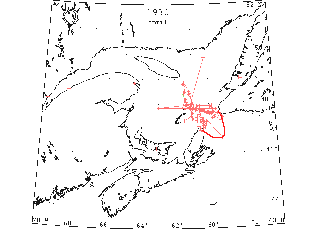
Apr 9 C.G.S. “Montcalm”. 8 a.m. position 46°34’N 60°06’W bound ice patrol. From North Sydney to present position no ice in sight. (RG42 Vol.371)
Apr 10 C.G.S. “Mikula” left Quebec 4 a.m. 8:30 am abeam Goose Cape. From Quebec to St. Paul strings of broken ice.
Apr 10 C.G.S. “Montcalm” 4 pm yesterday – from 8 a.m. yesterday then to position 4 pm 7 miles W of Cape Ray, no ice in sight. From last mentioned position on course to Bird Rock light broken ice. Today; 8 am patrolled from Low Point to St. Paul Island, then 7 miles W mag. Off Cape Ray. No ice sighted. Thence on course 292°T to 8 am. Position 47°56’N 60°53’W, heavy broken ice well open in places. From 8 am. Position patrolled to 4 pm position48°23’N 61°10’W encountered heavy and light broken ice, Proceeding toward Heath Point. If possible will land batteries at Bird Rock tomorrow. (RG42 Vol.371)
Apr 11 Cape Race: Heavy broken ice 46°37’N 53[59?]°13’W to 47°56’N 60°53’W (IIP p13#378)
Heavy and light broken ice well open 47°56’N 60°53’W to 48°30’N 61°11’W (IIP p13#379)
Light broken ice with occasional large open leads 48°30’N 61°11’W to 48°48’N 61°32’W (IIP p13#380)
Apr 11 “Albertic” berg and several growlers 48°23N 61°29’N to 45°23’N 46°04’W (IIP p13#381)
Apr 11 C.G.S. “Mikula” 8.30 am. Abeam of Cape Magdalene. Saw no ice of any description since leaving Saguenay River.
Apr 11 C.G.S. “Montcalm”. 8 a.m. From position 4 pm. Yesterday patrolled 48°48’N 61°32’W then 8 am. 48°23’N 61°29’W light broken ice with large leads of open water. Proceeding towards Bird Rock to land material. Will then patrol W. (RG42 Vol.371)
Apr 12 C.G.S. “Montcalm” Apr 11th. from 8 a.m. position to 48°10’N 61°26’W no ice. From last mentioned position to Bird Rock heavy and light close packed ice as far as could be seen. Position 4 pm. 47°41’N 60°59’W. Ice well broken, now proceeding to ascertain ice conditions on N coast of Cape Breton. 12th?. From 4 pm. Position yesterday patrolled toward Cape North no ice. Patrolled this morning from 9 miles mag. from Cape North to 8 am. Position 47°04’N 61°35’W. Met only 2 narrow strings of broken ice off Cape St. Lawrence. Am now proceeding to ascertain conditions W of Magdalen Islands. (RG42 Vol.371)
Apr 12 C.G.S. “Mikula” Apr 11th 7 p.m. 48°14’N 61°51’W. From Cape des Rosiers to present position saw no ice. Steered 4½ miles off Fame Point, 117°T on the regular steamer track. Apr 12th. 8 am. Met NW edge of packed broken ice 48°01’N 61°32’W. Thence steering 117°T passed through broken ice, close packed in places to 4 miles SE of Bird Rock, our position at 7.30 am. Now continuing on course to Cape Ray through heavy close packed and broken ice. (RG42 Vol.371)
Apr 14 C.G.S. “Mikula” Apr 13th 8 a.m. patrolled from 47°54’N 59°57’W on course 270°T going through heavy broken ice with some rafted and growlers very close packed in places. 7 a.m position 47°55’N 60°31’W same ice. From 7 a.m. position to Bird Rock and Bryon Island ice close packed in vicinity but clear water to N and W. 7 p.m. position 10 miles N 55°E mag. from Bryon Island. Ships entering the Gulf will do well to pass through Gut of Canso via East Point, PEI or along E coast Cape Breton and between Magdalen Islands and N coast of Cape Breton. Ice conditions via Cape Ray and Bird Rock track not favourable for ordinary shipping under present conditions. Apr 14th patrolled this morning from 48°04’N 61°20’W on course 353°T. Ice opening up with strong SW and rain. 5:25 a.m. cleared edge of packed ice approximate 48°12’N 61°21’W. Keeping on above mentioned course to 7 a.m. position 48°29’N 61°24’W mostly clear water except few strings broken ice and isolated pans. (RG42 Vol.371)
Apr 14 C.G.S. “Montcalm” Apr 13th. 8 a.m. patrolled via Cape Georges, thence on ship’s course in Northumberland Strait. 4 p.m. 46°04’N 63°23’W no ice sighted. From 4 p.m. patrolled from East Point, PEI then to position 8 a.m. 5 miles N. Gut of Canso sighted, no ice. Am proceeding through Northumberland Strait to ascertain ice conditions there. Apr 14th from position 4 p.m. patrolled to position 8 a.m. 4 miles W mag. from West Point, PEI. No ice sighted. Now stopped owing to fog. Will proceed around North Point as soon as fog clears. (RG42 Vol.371)
Apr 14 C.G.S. “Mikula”: Apr 14th. 7 p.m. patrolled from 7 a.m. position on course 353°T to 48°51’N 61°27’W through strings of broken ice with occasional growlers. Thence steering 152°T to 48°19’N 60°58’W. Weather too thick to observe conditions properly. 5 pm. Weather cleared, started patrolling towards Bird Rock. 6.25 pm. Stopped in heavy broken ice 7 miles NE of Bird Rock. (RG42 Vol.371)
Apr 14 C.G.S. “Montcalm” Apr 14th. from 8 a.m. position patrolled to 47°18’N 64°09’W thence to 4 pm position 47°17’N 63°47’W. No ice sighted. (RG42 Vol.371)
Apr 14 First craft to establish connection with the mainland from the Magdalen Islands this season, the motor vessel “C A Roland,” reached Halifax on Saturday afternoon. Captain Abraham Depres, master, stated that it was the earliest date in history that a boat had reached the mainland from the islands. With the exception of a few patches of field ice, no ice was sighted on the voyage. (HH 14/04/1930 p15#1)
Apr 15 C.G.S. “Mikula” patrolled from 4 p.m. position 47°59’W 60°58’W steering 264°T through heavy broken ice. This ice is drifting down from westward and has some very heavy rafted pans all through it. 7 a.m. position 11 miles NW by N Bird Rock light. (RG42 Vol.371)
Apr 15 C.G.S. “Montcalm” from 4 p.m. yesterday patrolled to 5 miles NW mag. from Deadman’s Island thence to 8 a.m. position 47°30’N 62°16’W. No ice sighted. (RG42 Vol.371)
Apr 15 Ice Report Broadcast By “Mikula” Warns Ice Conditions Via Cape Ray and Bird Rock are Unfavorable. That ships entering the Gulf of St. Lawrence would do well to pass through the Gut of Canso and thence by East Point, PEI, or along the east coast of Cape Breton and between the Magdalen Islands and Prince Edward Island. The “Mikula” reported ice conditions via Cape Ray and Bird Rock were not favorable for ordinary shipping under present conditions. The report said there was a narrow strip of ice between St. Paul’s Island and Cape North but otherwise no ice was in sight. (HH 15/04/1930 p17#5)
Apr 16 The last crossing over the ice from Summerside to Curling was made on Thursday. The ice moved off shore at Curling on Monday, but the in-wind prevented it from going out the Arm. The steamer “Homestead”, anchored off Corner Brook since last summer, went adrift in the ice on Monday, and has since been drifting about the Arm. (TWS, pg. 2, Col. 1)
Apr 16 C.G.S. “Montcalm” 15th p.m. from position 8 a.m. patrolled on course 49°T in 47°50’N 61°42’W met heavy broken ice extending as far as could be seen towards S and E. From this position followed N edge of ice to 47°58’N 61°04’W then our course 142°T to position 4 p.m. 47°50’N 60°56’W. Heavy close packed ice with few narrow leads open water. 16th a.m. from position 4 p.m. patrolled to 47°22’N 60°20’W encountered heavy close packed ice with occasional leads of open water. At this position believe was on southern edge of heavy ice. Packed ice extended towards NW and E as far as could be seen. Thence to position 8 a.m. 2 miles NW St. Pauls Island met scattered ice. (RG42 Vol.371)
Apr 16 C.G.S. “Mikula” still patrolling 3:20 a.m. through broken ice from 47°55’N 59°56’W to 47°48’N 59°42’W here came to SE of pack. Thence sighted pans and string broken heavy ice to 47°51’N 63°00’W our position 7 a.m. Western ice drifting out very slowly at present but swell heaving from SSE is pounding ice to slob and opening up on southern edge. (RG42 Vol.371)
Apr 16 C.G.S. “Mikula”: Patrolled from 7 a.m. position along the N side Bryon Island and Bird Rock and along N edge of western pack which extends 8 to 10 miles off shore in that vicinity. From 10 miles N 63°E mag. from Bird Rock steered 97°T to 47°56’N 59°58’W our 7 a.m. position, passing through broken heavy ice with occasional leads of water. From this position heavy close packed broken ice in all directions. (RG42 Vol.371)
Apr 16 Georgetown – ferry running April 16th (Pat 7 Apr 1934 p7 c7)
Apr 17 C.G.S. “Mikula” 16th p.m. Patrolled from 49°51’N 60°13’W to Bird Rock. Heavy broken ice. N edge of pack extends 3 miles N of Bird Rock and W and 1 mile below Bryon Island. 7 p.m. 47°40.5’N 60°57’W. 17th a.m. 7 a.m. patrolling NW end of pack in 47°37’N 60°57’W. NNW gale all night and still continues. Ice on weather edge pounding and breaking up with heavy swell heaving to it. “P.T. Dodge” followed “Mikula’s” advice, course through Strait of Canso to East Point, PEI and Gaspe direct. No ice sighted. (RG42 Vol.371)
Apr 17 C.G.S. “Montcalm” 16th p.m. From position 8 a.m. patrolled to St. Pauls Island meeting only isolated pieces of light ice. From St. Paul Island to 5 miles off Ingonish thence to position 4 p.m. 6 miles E of White Head encountered only 2 narrow strings well broken ice 6 miles S of St. Pauls Island. (RG42 Vol.371)
Apr 17 C.G.S. “Montcalm” commenced patrolling 4.30 a.m. From Cape North on course 10°T met first ice, light and broken with occasional growlers in 47°07’N 60°20’W. Same ice as far as can be seen towards NWN and NE. There does not appear to be any ice between our position and St. Pauls Island. Ice drifting fast towards SE. (RG42 Vol.371)
Apr 17 Ice conditions via Cape Ray and Bird Rock to the Gulf of St. Lawrence are still unfavorable for ordinary shipping under the present conditions, according to a message from the ice patrol boat “Mikula”. A small pack ice about a quarter of a mile in circumference was sighted to the northwest St. Paul’s Island. No other ice was sighted, according to the report. (HH 17/04/1930 p17#5)
Apr 17 The steamer “Lovat” will make her first trip to Magdalene Islands from Halifax on 17th instant calling at Souris enroute. (Pat 11 Apr p5 c1)
Apr 19 First arrival of season at Quebec. (WBB)
Apr 19 C.G.S. “Montcalm”: Apr. 18th. a.m. From 4 p.m. position on course 64°T to 47°30’N 60°35’W thence on course 118°T to 8 a.n. position 47°26’N 60°24’W passed through close packed ice, no water in sight as far as could be seen Proceeding along E coast Cape Breton. Apr. 18th p.m. From 8 a.m. position patrolled on course 172°T. Southern edge of field in 47°10’N 60°20’W. This field extends towards NW by NNE and SE as far as can be seen on same course to 5 miles E of Cape North, thence to Sydney no ice sighted. 3:30 p.m. arrived North Sydney. (RG42 Vol.371)
Apr 19 C.G.S. “Mikula”: Apr 18th a.m. Patrolled from 47°21’N 60°22’W to St. Pauls Island through heavy broken ice on N 84°E mag. for 8 miles then ice scattered and broken with many leads of open water through. 7 a.m. position 47°29’N 59°37’W. Ice here about same. Apr 18th p.m. Patrolled from 7 a.m position to 4 miles off Cape Ray thence 7 miles off Channel Head. Here came to S edge of the pack. Ice heavy and hard, but open in many places from last mentioned position. Steering 287°T, passing through heavy, broken ice with some open leads of water to 47°39’N 60°05’W thence on same course steamed 2 miles in clear water. Then broken open ice and slob until clear of all ice 15 miles SE mag., Bird Rock. Position 7 p.m. N ¼W mag. 5 miles from Bird Rock. No ice in sight in any direction from here. Apr 19th a.m. Patrolled this morning from Bird Rock to approximate 48°10’N 61°09’W no ice sighted. (RG42 Vol.371)
Apr 21 C.G.S. “Mikula” considerable ice from Cape Ray to Bird Rock also from St. Paul Island to Bird Rock. (HB #2121 Apr 30)
Apr 22 C.G.S. “Montcalm”: patrolled this morning from Cape North to St. Pauls Island. No ice sighted. C.G.S. “Mikula”: patrolled this morning through heavy close packed broken ice from 47°19’N 61°27’W steering 62°T to 47°30’N 61°02’W. Thence steering 355° through same kind of ice but more scattered and open to 47°47’N 61°03’W our 7 a.m. position. This pack is drifting slowly towards N coast of Cape Breton and is likely to get across the ship track between Magdalen Islands and N side of Cape Breton. (RG42 Vol.371)
Apr 22 North Sydney, owing to ice conditions in the Gulf the fishing schooner “Nelson L,” failed to sail for the banks as was expected. (HH 24/04/1930 p13#5)
Apr 23 The strong breeze of wind on Mon. finished breaking up the ice in the Humber Arm, and yesterday many motor boasts were on the water. (TWS, pg. 2, Col. 3)
Summer is in much evidence here now. All the ice is gone… (TWS, pg. 5, Col. 6)
Apr 23 Br SS “Duchess of Richmond” reports: sighted first ice in 47°20’N 59°15’W, consisting of light open string with some heavy pieces scattered through it, thence to 47°46’N 60°20’W, passed through several similar strings. (NYMR, p.13, col.2).
Apr 23 CGS “Montcalm” reports: patrolled on course 303 (true) clearing the northern edge of light broken ice and growlers in 47°43’N 60°32’W; the northern edge of ice fields with light broken ice and growlers in 47°55’N 60°28’W. (NYMR, p.13, col.2).
Apr 23 C.G.S. “Mikula”: 22nd Apr. p.m. Cleared N edge of pack mentioned in this morning’s message 8 miles S ½E mag. from Bird Rock. No ice in vicinity Byron Island or Bird Rock as far N and W as could be seen. From Bird Rock steering 105° in clear water until reaching out 7 a.m. position 47°42 60°15’W. Here met broken ice and slob with some large hard growlers all through it. On same course to 47°40’N 60°00’W passed through broken strings of slob ice and ice with some isolated growlers. Thence on same course to 7 miles off Cape Ray no ice sighted. Ships entering Gulf from E would do well to pass via Cape Ray and from there shape course to pass ~ 4 miles E of Bird Rock, thence from Cap des Rosiers. This ice mentioned between Cape Ray and Bird Rock can be easily passed through with any ordinary ship by taking proper precautions. Ships coming from W had better pass through Gut of Canso via East point or Northumberland Strait. Field ice between Magdalen Islands and N coast of Cape Breton likely to give trouble on that track for the next few days. From 6 miles off Cape Ray steering 235° to St. Pauls passed 1 string of broken ice and slob 8 miles off St. Pauls about 1 mile wide extending NNW and SSE mag. as far as could be seen. From St. Pauls to Cape North no ice sighted. 7 p.m. in Aspy. (RG42 Vol.371)
Apr 24 C.G.S. “Mikula”: expect finish coaling 6 p.m. and will proceed direct to break ice in Gaspe Bay and Harbour. (RG42 Vol.371)
Apr 24 C.G.S. “Montcalm”: 23rd Apr. p.m. From position 8 a.m. patrolled on course 303°T. Clear northern edge of light broken ice and growlers in 47°43’N 60°32’W. Thence patrolling to 47°55’N 60°42’W sighted no ice, but am now on northern edge of ice field with same kind as mentioned above. 24th April a.m. Patrolled this morning from 47°45’N 60°28’W on course 292°T to 47°49’N 60°46’W following NE edge wide string of light broken ice with occasional growlers. Thence to 5 miles SE of Bird Rock passed on NE edge field ice extending as far as could be seen towards SW and W thence to position 8 a.m. Bird Rock, no ice sighted. (RG42 Vol.371)
Apr 24 Br. SS “Beaverhill” reports: slob ice extending southward of a line from 47°31’N 59°40’W to 47°35’N 59°49’W. Passed through open field ice from 47°46’N 60°22’W to 47°48’N 60°27’W. (NYMR, p.13, col.2).
Apr 24 CGS “Montcalm” reports: met the northern edge of an ice field in 47°50’N 60°27’W, thence to 47°39’N 59°45’W, passed through well broken loose ice with occasional small growlers and large leads of open water. (NYMR, p.13, col.2).
Apr 25 “Montcalm” met field ice, heavy close packed and rafted, 8 miles west-southwest (mag), from Cape Anguille extending as far as could be seen to the northwestward and westward, and to the coast of Newfoundland. (NYMR, p.13, col.2).
Apr 25 Point Amour, heavy open ice everywhere. (NYMR, p.13, col.2).
Apr 25 Belle Isle, five bergs; scattered strings of ice on the Newfoundland coast. (NYMR, p.13, col.2).
Apr 25 C.G.S. “Montcalm”: a.m. – met field of heavy close packed rafted ice last evening 8 miles WSW mag. from Cape Anguille extending as far as could be seen towards NW and W also to coast of Newfoundland. Elsewhere in Gulf ice conditions remain practically unchanged. On course from Cape Ray to Bird Rock there are several fields of light open ice which are easily navigable. Vessels passing through Gut of Canso via East point, PEI to coast of Gaspe report meeting no ice. Vessels can also pass at present via Cape North thence S of Magdalen Islands and to Gaspe coast without encountering ice. (RG42 Vol.371)
Apr 25 C.G.S. “Mikula”: patrolled from Sydney along E coast of Cape Breton to Cape North thence to Cape St. Lawrence, no ice. From 3 miles off Cape St. Lawrence steering 270° to 9 miles off Amherst thence to Deadmans Island and from there to 48°02’N 63°15’W saw no ice on course steered. On course from St. Lawrence to Amherst could see southern edge of pack previously reported. Bound to Gaspe. C.G.S. “Montcalm”: 24th Apr.. p.m. From Bird Rock patrolled on course 62°T. Met northern edge of ice field in 47°50’N 60°27’W. From last mentioned position to position 4 p.m. 47°39’N 59°45’W passing through well broken loose ice with occasional small growlers and large leads of open water. (RG42 Vol.371)
Apr 26 C.G.S. “Montcalm”: This a.m. patrolled from 8 miles WNW from Cape Anguille on southern edge heavy close packed ice field to Cape Ray. No ice sighted. Will patrol today on our recommended course Cape Ray to Bird Rock. Ships following our recommended courses in Gulf having no difficulty. (RG42 Vol.371)
Apr 26 C.G.S. “Mikula”: 12:20 p.m. [25th?] arrived Gaspe and began cutting 1 mile inside Sandy Beach block. Cut out and cleared Government Railway Wharf and slice and cut all ice in Bay to 1 mile from Block at entrance to Gaspe Basin. Ice averaging 2’ thick. (RG42 Vol.371)
Apr 26 Grindstone,– Magdalen Islands all clear of ice. (HH 26/04/1930 p21#5)
Apr 27 C.G.S. “Mikula”: p.m. From position 8 a.m. (8 miles N Cape St. Lawrence) patrolled on course 263°T to 47°06’N 61°25’W thence altered course 46°T. In 47°23’N 60°58’W met western edge of heavy close packed ice field extending towards ENE and ESE as far as could be seen. At last mentioned position to 4 pm position off Bird Rock. No ice sighted. Will patrol recommended course Bird Rock to Cape Ray. (RG42 Vol.371)
Apr 27 C.G.S. “Mikula” from 6:45 p.m. yesterday’s position patrolled to 6.7 miles 65°E mag. from Bird Rock. Saw no ice. From there steered 143° and met no ice until reaching 47°34’N 60°34’W, passed through isolated growlers and hard pans to 47°25’N 60°24’W. In last mentioned vicinity the ice is heavy and close packed but broken considerably with the swell. The above mentioned pack is moving slowly towards the SE at present and opening up as it drifts towards St. Pauls and Cape North. 7.10 a.m. 12 miles N by E mag. from Cape North. Broken heavy ice all around here. (RG42 Vol.371)
Apr 28 C.G.S. “Mikula”: Finished breaking all ice in Gaspe Bay and Basin today and left for patrol. 6:45 p.m. in 48°05’N 61°24 (17 miles NW Bird Rock). Saw no ice from Gaspe to here. [may actually precede Apr 27 report]. C.G.S. “Montcalm”: p.m. From position 8 a.m. patrolled on course 115°T passing through 2 miles heavy close packed ice extending E and W as far as could be seen. Thence to position 4 p.m. approximate 47°45’N 60°09’W no ice sighted. (RG42 Vol.371)
Apr 28 C.G.S. “Montcalm” at 47°50’N 60°31’W met northern edge of heavy close packed ice field, patrolled on course 115 T, passing through 2 miles of heavy close packed ice extending E and W as far as could be seen, but the visibility was poor. (HB # 2122 May 7)
Apr 29 St. Paul Island, field of loose ice about 6 miles northward; western edge about 15 miles E of Cape St. Lawrence. (HB # 2122 May 7)
Apr 30 “Montcalm”from 8 am position patrolled on course 293 true to 47°55’N 60°48’W thence to Bird Rocks and to position 4 p.m. 47°27’N 60°39’W. Ice encountered well broken and open extending 5 miles southwest and about 8 miles east in 47°40’N 59°52’W and small field in 47°42’N 60°02’W. Now patrolling towards Cape North. (NYMR, p.13, col.1).
Apr 30 Fields well broken ice between St. Paul’s and Cape North and in following positions: 47°20’N 60°04’W and 47°26’N 59°46’W. Now proceeding on track Cape Ray to Bird Rocks. (NYMR, p.13, col.1).
Apr 30 C.G.S. “Montcalm”: p.m. From position 8 a.m. patrolled on course 147°. In 47°16’N 60°36’W met northern edge well broken ice field. Its western edge 4 miles W and extending Eastward as far as could be seen. Southern edge of this field 3 miles NE mag. from Cape North proceeding to ascertain southern edge above mentioned ice field between Cape North and St. Paul. (RG42 Vol.371)
Apr 30 St. Pauls Island, string of ice about 1 mile wide half way between Island and Cape Breton coast extending S to Aspy Bay and N as far as can be seen. Can see open water behind to NE. Ice on horizon to N and E and SE. No ice in sight to S. (RG42 Vol.371)
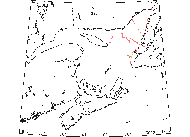
May 1 C.G.S. “Montcalm”: 30th April from 4 p.m. position patrolled to St. Pauls Island thence to 10 miles W mag. from Cape Ray and altered course to 295°T to position 8 a.m. 47°39’N 59°50’W. Fields of well broken ice between St. Pauls and Cape North and in following positions 47°29’N 60°04’W and 47°26’N 59°46’W. Now proceeding on track Cape Ray to Bird Rock. (RG42 Vol.371)
May 2 Point Amour reports heavy close packed ice everywhere. (NYMR, p.13, col.1).
May 2 Belle Isle reports heavy open ice in Straits; seven bergs and three growlers. (NYMR, p.13, col.1).
May 2 C.G.S. “Montcalm”: Last night patrolled from position 8 a.m. to Cape Ray, thence to Cape Anguille. Position 4 p.m. 10 miles W mag. from Cape Anguille. Between Cape Anguille and Cape Ray sited only a few small growlers. (RG42 Vol.371)
May 3 C.G.S. “Montcalm”: From 4 p.m. position patrolled to St. Pauls Island thence to Cape St. Lawrence and to 8 a.m. position off Cheticamp. No ice sighted. Proceeding Charlottetown. (RG42 Vol.371)
May 5 C.G.S. “Mikula”: (last night) patrolled from 4 miles W mag. from Cape Ray to Bird Rock and from there to 47°28’N 60°33’W our position 7 p.m. Saw no ice of any description on this patrol. (This morning) patrolled from 7 p.m. position (4th) to St. Pauls and from NE St. Pauls steamed 10 miles on course S 79°E mag. our 7 a.m. position and saw no ice. (RG42 Vol.371)
May 6 Point Amour reports heavy close packed ice everywhere, and on the north shore; scattered ice to the eastward; six bergs in sight. (NYMR, p.12, col.3).
May 7 C.G.S. “Mikula”: (last night) patrolled from 7 a.m. position to 47°30’N 59°32’W and from there to Cape Anguille and saw no ice. From Cape Anguille to 48°14’N 59°29’W here met heavy broken ice, very close packed along the western edge but open towards the E. The western edge of this pack extended N mag. as far as could be seen also in and across St. Georges Bay. 7 p.m. anchored Codroy Roads. Patrolled (this morning) from Cape Anguille to Cape Ray and from there to 47°22’N 59°18’W our 7 a.m. position, saw no ice. Ships bound from E or W may take any desired course through Cabot Straits and up the Gulf to Quebec. Ships bound to Corner Brook or any part N side of Newfoundland will have difficulties at present. The western edge of the pack is now 17 miles N 10°E mag. from Cape Anguille. This ice is closely packed and heavy on western edge but more open as you proceed E. Western edge runs about N and S mag. (RG42 Vol.371)
May 7 CGS Mikula reports: from 48°12’N 59°34’W to 48°21’N 59°27’W, encountered broken ice which extends as far east as can be seen and also south as far as the shore. (NYMR, p.12, col.3).
May 7 M.G. Shepard came in from Lark Hr. by motor boat on Mon. He told the Western Star that the ice was in on the land, and nothing had been done at fishing to date. Yesterday the steamer “George L”. was unable to reach Lark harbor owing to drift ice. The ice extended across the bay, blocking both passages. A good breeze of south or southwest wind is required to clear the coast. (TWS, pg. 2, Col. 4)
May 7 C.G.S. “Mikula”: (last night) patrolled from 7 a.m. position to 48°02’N 59°33’W and from there to St. Pauls and Sydney saw no ice. 7 p.m. in Sydney Harbour. (RG42 Vol.371)
May 8 C.G.S. “Mikula”: (last night) patrolled from 7 a.m. position steering 12° to 48°12’N 59°34’W saw no ice previous to reaching this position. Here met broken ice and followed N edge to 48°21’N 59°27’W our 7 a.m. position. This ice extends as far E as can see also S as far as the shore. (RG42 Vol.371)
May 9 From 48°58’N 59°23’W to 45[49?]°25’N 59°27’W, met heavy and broken ice, thence to 49°37’N 60°00’W, heavy and broken ice. (NYMR, p.12, col.3).
May 9 Point Amour, heavy packed ice everywhere. (NYMR, p.12, col.3).
May 9 Belle Isle, heavy open ice everywhere; seven bergs and 5 growlers in sight. (NYMR, p.13, col.1).
May 9 C.G.S. “Mikula”: (last night) patrolled from 7 a.m position to 48°58’N 59°23’W. Here met W edge of heavy broken ice. From there to 49°25’N 59°27’N steering 356° ice heavy and broken. From last mentioned position to 49°37’N 60°W steering 299 ice conditions same as above mentioned. (This morning) patrolled from 49°37’N 59°43’W to 49°40’N 60°08’W and from last mentioned position to 49°55’N 60°10’W our 7 a.m. position. Heavy open ice at present and this appears to be the western edge of the pack. (RG42 Vol.371)
May 10 from 7 a.m. position to 49°52’N 60°38’W passed through heavy close packed ice. At last mentioned position came to NW edge of ice and continued in clear water to 50°N 61°44’W 6 miles off Natishquan Point. From last position steering S 17°E mag. to 49°41’N 61°12’W here met N edge of pack to 49°25’N 61°28’W. From here can see strings of ice in all directions. (This morning) patrolled 18 miles 38°T. from Heath Point on course 345°T. Passed through soft sheet ice for 8 miles. On same course from last mentioned position to Natishquan Point no ice sighted. The above mentioned ice is coming down from the N side of Anticosti with fresh NW wind. It is soft and mushy and easily passed through. 7 a.m. off Natishquan Point. (RG42 Vol.371)
May 12 C.G.S. “Mikula”: Patrolled through heavy broken ice from Red Island to Southhead Bay of Islands This ice extends from shore as far as can be seen. (RG42 Vol.371)
May 13 Point Amour reports heavy close packed ice everywhere. (NYMR, p.13, col.1).
May 13 Belle Isle reports heavy close packed ice everywhere; 37 bergs and numerous growlers in sight. (NYMR, p.13, col.1).
May 13 Canadian Mail and Passenger Ship at Corner Brook and as ice conditions are bad at present she is likely to be caught there for some time unless assisted by the “Mikula”. (RG42 Vol.371)
May 13 C.G.S. “Mikula”: (last night) patrolled since 7 a.m. from South-head, Bay of Islands, through heavy broken ice to 49°39’N 59°30’W and from there back to York Harbour out 7 p.m. position. Strong SW wind is pushing ice down about 1½ miles per hour and opening it up considerably. (This morning) patrolled from Gursey Island in course 232° to 48°54’N 59°01’W passing through heavy close packed and open ice. In some places open leads of water towards land. Ice open and scattered across the entrance Port au Port but very close packed from Bearhead to Southhead, Bay of Islands. (RG42 Vol.371)
May 14 CGS Mikula reports close packed ice on Newfoundland coast from Bear Head to Bonne Bay and as far eastward and northward as could be seen; from Cape Anguille to Cape Ray, some strings of slob ice along shore. (NYMR, p.13, col.1).
May 14 C.G.S. “Mikula”: (last night) patrolled since 7 a.m. in vicinity of Bay of Islands and in Bay to assist SS “North Voyageur”. Ice heavy and close packed in places but many leads of open water with heavy pans through it. 7 p.m. abeam of Long Point with “North Voyageur” following. (This morning) patrolled from W edge of pack 4 miles NNW of Cape St. George. Steered 222° to 48°09’N 59°52’W no ice and from last position to Cape Anguille no ice. Close packed on Newfoundland coast yesterday from Bearhead and as far E and N as could be seen. Left steamer “North Voyageur” off Red Island last night in clear water. (RG42 Vol.371)
May 14 The bridge constructed by Jack Frost has disappeared, and the bay is now free of ice. (TWS, pg. 1, Col. 7)
May 15 C.G.S. “Mikula”: (last night) Patrolled since 7 a.m. from Cape Anguille to Cape Ray and from there to Bird Rock. From Anguille to Ray some strings of slob ice along shore. From Cape Ray to Bird Rock on usual ship’s track no ice sighted. From Bird Rock steering S 14°W mag. to Heath Point Lightship no ice sighted. N coast of Newfoundland from Port au Port E and N blocked with heavy ice yesterday. (This morning) patrolled from 49°03’N 61°34’W steering 95° to 49°28’N 64°04’W to western edge of pack. (RG42 Vol.371)
May 15 Orders to C.G.S. “Mikula” “Consider further patrol unnecessary. Return Quebec ..”. (RG42 Vol.371)
May 16 Point Amour, heavy close packed ice stationary; numerous bergs and growlers. (NYMR, p.13, col.1).
May 16 Belle Isle, heavy close packed ice everywhere; numerous bergs and growlers, mostly in entrance to Strait. (NYMR, p.13, col.1).
May 21 The SS “Sagona” has been jammed in the ice at Port au Choix since Sun. Yesterday’s report stated she was making slow progress. (TWS, pg. 2, Col. 3)
May 23 Point Amour, heavy close packed ice everywhere with numerous bergs and growlers; Belle Isle, heavy open ice everywhere with numerous bergs. (NYMR, p.13, col.1)
May 28 Point Amour, heavy open ice everywhere; numerous bergs. (HB #2126 Jun 4)
May 29 “Sagona” met much ice- Ship unable to get north of Port au Choix- The “Sagona” arrived at Curling at 8 pm on Thur. from her first trip on the Straits of the season. Leaving here on the 12th the ship encountered drift ice before getting clear of Bay of Islands and had to contend with it throughout the trip until Bonne Bay was reached coming south. It is evident from reports that the Gulf is full from the Mecattina [?] Islands, or further west than that, across to Bonne Bay, and that the portion of the Gulf north of these 2 points is blocked. The ship reached Port au Choix on the 17th after having been jammed 2 days off Point Rich. Wednesday evening the wind shifted to the S.E. which shifted the ice off a little and made it possible for the ship to get back. All along from Point Riche to Bonne Bay the edge of the ice could be plainly seen, and a change of wind will again see the coast blocked from Bonne Bay north. (TWS, pg. 1, Col. 5)
May 29 On Monday the ice conditions were about the same as when the “Sagona” returned here last week. (TWS, pg. 2, Col. 3)
Jun 2 Point Amour, reports heavy open ice distant; many bergs. (HB #2127 Jun 11)
Jun 4 “Sagona” reached Battle Harbour- “Sagona” arrived at Curling on Monday with about 20 passengers and a small portion of freight… The weather was fine throughout the trip and very little drift ice was met until the ship reached Henley Hr. where the first Arctic ice was encountered. (TWS, pg. 1, Col. 6)
Jun 11 Point Amour, heavy ice everywhere moving with numerous bergs and growlers. (HB #2128 Jun 18)
Jun 16 Point Amour, numerous bergs and growlers. (HB #2129 Jun 25)
Jun 18 “Kent County” first vessel of the season through the Strait of Belle Isle. (RG42 Vol.371)
Jun 18 First Westbound steamer through the strait of Belle Isle. (WBB)