1929 Season
Nov 25 Pilotage officer, Father Point: Ice starts making. (CIS IC0708)
W.J. Balcom, Master, C.G.S. “N.B. McLean”: The Gulf of St. Lawrence is more or less covered with ice and navigation in the western part is closed (except for icebreakers and ships strengthened and having good power.) After approximately January 10th each year, but there have been exceptional years such as 1929 and 1933 when navigation closed for ordinary ships early in December. (CIS IC0728)
Dec 9 Last eastbound steamer through the Strait of Belle Isle. (WBB)
Dec 11 Last departure of the season from Quebec. (WBB)
Dec 24 J.A. Ward, Lightkeeper, Miscou Point, New Brunswick: Closing date. (CIS IC0756_2)
Dec 27 SS “Lovat” made her last trip of the season to the Magdalene Islands on December 27th. New ferry Georgetown to Newport doing satisfactory service. (Pat 10 Jan 1929 p2 c6)
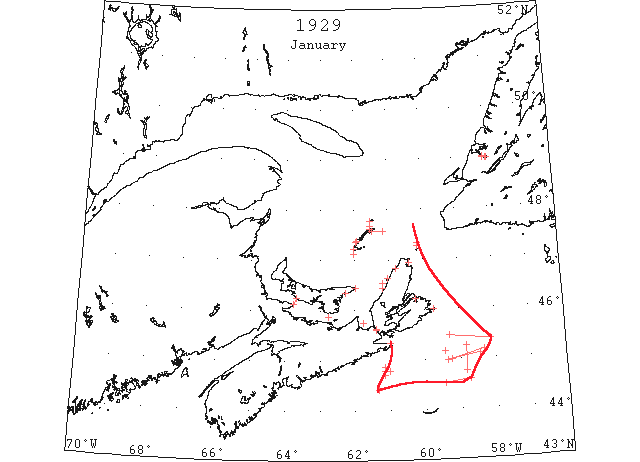
Jan Some field ice was carried seaward from the Gulf of St. Lawrence by the Cape Breton Current and was reported during the latter part if the, month from 60 miles SE of Cape Breton. (IIP p77)
Jan 4 Georgetown – both ferry boats running… not one cake of ice to be seen in the harbour. Boats are running to Boughton Island and Panmure Island. One vessel loading produce for Halifax. (Pat 4 Jan p4 c4)
Jan 9 The steamer “Terne” left Cornerbrook on Sunday (January 6th) and arrived in Georgetown today (no mention of ice). (Pat 9 Jan p1 c1)
Jan 10 Five potato boats loading in Georgetown. (Pat 10 Jan p1 c7)
Jan 14 Georgetown – 4 steamers in the harbour loading or waiting to load. Note lateness of the shipping season. (Pat 14 Jan p3 c?)
Jan 15 Lightkeeper, East Point, PEI: Ice formed in vicinity. (CIS IC0993)
Jan 15 Car ferry delayed due to high winds and heavy ice packed on the Borden side of the Strait. (Pat 15 Jan p1 c7)
Jan 15 Magdalen Islands, close packed ice inshore. (HH 15/01/1929 p15#1)
Jan 16 Deer Lake is entirely free of ice just now, which is a rare thing for this time of the year. (TWS, p.1).
Jan 16 The Skating Rink has not yet opened, due to the fact that there has not been sufficient frost to get a good sheet of ice. (TWS, p.1).
Jan 16 Ice formed in Humber Arm down as far as Childs Point on Wednesday. (TWS, p.2).
Jan 16 The wind Monday night broke the ice from Bagg Bros. across to Loaders and carried it to the bottom of the Arm. (TWS, p.2)
Jan 16 Etang du Nord, light close packed ice everywhere. (HH 16/01/1929 p13#1)
Jan 16 Georgetown Harbour is reported to be still clear of ice (steamer departing). ((Pat 16 Jan p8 c4)
Jan 17 Point Tupper – Light close packed ice in shore. St. Paul’s Island – slob ice north. Magdalen Islands – Slob ice everywhere. (HH 17/01/1929 p13#1)
Jan 18 Georgetown – Pictou service to be started on Friday (18th). (Pat 17 Jan p5 c1)
Jan 18 “Stanley” slated to be on the Georgetown-Pictou run will be put on the Borden-Tormentine route to replace the ferry recently damaged by grounding. (Pat 18 Jan p1 c7)
Jan 19 Dept. Mar. & Fish: Cheticamp, light ice all along the coast since 3 days. Moved off this morning with SW wind. St. Pauls Is., close slob ice everywhere. Mulgrave, NS, considerable slush ice. Magdalen Islands: Etang du Nord, open ice; Amherst Is., close packed ice; Pleasant Bay, slob ice in shore. Souris, light ice in harbour. No drift ice in sight. Cape Tormentine, small amount of ice in Straits. Will shove out. Ferry made 6 crossings in the last 24 hours. (RG42 Vol.371)
Jan 19 Dept of Mar & Fish: Cape Ray, no ice in sight. Elmira, no ice in sight in vicinity of East Point. Cape Anguille, no ice in sight. (RG42 Vol.371)
Jan 21 The Norwegian steamer “Terne” is caught in the ice, three miles from shore, off Margaree, CB, and is in great danger of drifting on shore in face of a north-west gales. On account of ice in the Straits of Canso her course was set to take her around Cape North. The steamer became hemmed in by ice and up until late on Monday afternoon had drifted within three miles of the coast. (HH 22/01/1929 p1#4)
Jan 21 SS “Terne” sailed from Georgetown yesterday for Havana. This is the last cargo of potatoes to be shipped by water from Island ports this winter. Georgetown Harbour is reported as being practically clear of ice. (Pat 21 Jan p5 c3)
Jan 21 “Terne? was trapped in ice since 21 January off the NW coast of Cape Breton. (Pat 8 Feb p5 c6)
Jan 22 Dept of Mar & Fish: St. Pauls Is., no ice in sight (visibility ½ mile). Magdalen Is.: Grosse Isle, light close packed ice as far as can be seen; Old Harry, light close packed ice as far as can be seen; Pleasant Bay, no ice in sight. Elmira, heavy close packed ice vicinity of East Point. (RG42 Vol.371)
Jan 22 The Norwegian steamer, “Terne,” which has been caught in the ice fields of the Cape Breton coast during the past 24 hours, in the vicinity of Margaree, was on Tuesday night still drifting south with the ice packs and could not be seen by the inhabitants of Margaree, who were the first to discover her plight. On Monday afternoon if was feared that the steamer would be driven on shore by the ice pack but she managed to weather through her difficulties, and during Monday night passed beyond Margaree. The steamer “Stanley” which was summoned to the relief of the “Terne” when her position became bad on Monday, was caught in the ice flows [sic] and obliged to turn back.. (HH 23/01/1929 p1#8, p4#4)
Jan 22 Car ferry experiencing heavy ice packed by the gale (Borden-Tormentine). (Pat 22 Jan p1 c3)
Jan 23 The SS “Humber Arm” broke a channel through the ice out as far as Meadows on Sunday. (TWS, p.2).
Jan 23 Owing to the ice not being firm between Summerside and Curling, the people crossing Humber Arm have had to do so by way of Corner Brook. (TWS, p.2).
Jan 23 Dept of Mar & Fish: St. Pauls Is., no ice in sight. Magdalen Is.: Grosse Isle, heavy close packed ice everywhere; Old Harry, heavy close packed ice everywhere; Etang du Nord, heavy close packed ice everywhere; Pleasant Bay, no ice in sight. (RG42 Vol.371)
Jan 23 Point Tupper – Heavy close packed ice. ([HH?] 23/01/1929 p13#1)
Jan 23 Ice in Canso Strait blocking Cape Breton/Pt. Tupper ferry. (Pat 23 Jan p1 c2)
Jan 23 Borden-Tormentine – Ice conditions are reported very bad. Ice has been piled on the P.E.I. side by gales. Ice conditions around Canso are reported at present as bad. (Pat 23 Jan p1 c7)
Jan 24 Cape Race: Field ice 45°28’N 59°18’W to 45°23’N 58°08’W. (IIP p31#2)
Jan 24 Dept of Mar & Fish: Magdalen Is.: Grosse Isle, about 3 miles of light broken ice in shore, going E; Old Harry, no ice in sight; Pleasant Bay, no ice in sight; Etang du Nord, close packed ice. Cheticamp, ice keeps blocked on shore with W and NW wind. (RG42 Vol.371)
Jan 24 The “Stanley” met heavy rafted ice from 6 to 8 feet thick in the Strait of Canso. (Pat 24 Jan p1 c2)
Jan 24 SS “Terne” caught in the ice field off the NW coast of Cape Breton, being pushed along by a 50 mile NW gale. Driven slowly towards Grand Etang through packed ice. (Pat 24 Jan p1 c7)
Jan 25 Cape Race: Scattered field ice 45°00’N 59°15’W to 45°10’N 58°20’W. (IIP p31#3)
Jan 25 Dept of Mar & Fish: Magdalen Is.: Grosse Isle, about 1 miles broken ice in shore moving E; Old Harry, no ice in sight; Pleasant Bay, no ice in sight; Etang du Nord, close packed ice; Amherst Is., light broken ice. Cheticamp, NW wind keeps ice blocked in shore. St. Pauls Is., no ice in sight. Cape Ray, no ice in sight. Elmira Bay, today and yesterday, some open water SW of East Point, elsewhere heavy, close packed ice. (RG42 Vol.371)
Jan 25 Yesterday afternoon the “Stanley” had forced her way through the Strait of Canso but was driven back through the Strait by the NW gale. (Pat 25 Jan p1 c7)
Jan 25 “Montcalm” is breaking ice in Sydney Harbour. (Pat 25 Jan p1 c7)
Jan 26 Cape Race: Loose field ice 45°06’N 58 °27’W to 44°58’N 59°22’W. (IIP p31#4)
Jan 26 Cape Race: Slob ice 44°24’N 61°20’W. (IIP p31#5)
Jan 26 Dept of Mar & Fish: Magdalen Is.: Grosse Isle, about 2 miles light broken ice in shore; Etang du Nord, light close packed ice; Amherst, light open ice about 6 miles from shore; Pleasant Bay, no ice in sight. Cheticamp, ice packed in shore. Elmira, heavy close packed ice in vicinity East Point. Cape Ray, no ice in sight. (RG42 Vol.371)
Jan 26 The Canadian government steamer “Montcalm” has been ordered to proceed from Sydney, NS to Bay of St. George, Nfld., to release the Farquhar steamer “Sambro” which is ice-locked there. Icy conditions in the Northumberland Straits last week resulted in the temporary crippling of the Prince Edward Island car ferry, which was held up at Tormentine with a broken bow propeller. The government steamer “Stanley” was dispatched to aid the ferry but was unable to do so. (HH 28/01/1929 p13#5)
Jan 28 Cape Race: Field ice in band 4 miles wide stretching N & S 45°09’N 59°26’W. (IIP p31#6)
Jan 28 The following ice reports have been received at the local agency for the Marine and Fisheries department: Narrow field of slob ice in 44°47’N extending westward from 61°N [W?] 61°09’W. Two similar fields observed approximately five miles north and south of this position. Field of loose and pancake ice from 45°06’N 58°27’W to 44°58’N 59°22’W extending to horizon north and south. Scattered patches of field ice from 44°36’N 58°45’W to 44°31’N 59°27’W. (HH 29/01/1929 p13#5)
Jan 28 “Montcalm” is ordered to proceed to Bay of St. George, Newfoundland to release the Farquar steamer “Sambro” which is ice locked there. (Pat 28 Jan p1 c1)
Jan 29 St. Paul’s Island – no ice in sight. Point Tupper – Heavy close packed ice. Scatari – Slob ice north and east. (HH 29/01/1929 p13#1)
Jan 29 Car ferry running almost on a summer schedule due to loose ice (Borden/Tormentine). (Pat 29 Jan p1 c8)
Jan 30 The sailing of the steamer “Humber Arm” last Thursday was not a record date for navigating the Humber Arm in winter. In 1902 the schooner “Belle J. Neal” sailed from Summerside, Bay of Islands, for Boston. The vessel completed the trip and returned to Curling again on 18th March without encountering any ice during the voyage. Not until the first week of February that year was the Humber Arm solidly frozen over, and a month later it was completely free of ice. People who crossed the Arm yesterday told us that at present the ice is scarcely fit to walk on, at some places they could push a stick through. (TWS 30 Jan 1929 p.2)
Jan 30 Mulgrave – Coastal steamer “Margaretville” sank after being crushed by a large ice floe and dragged 60 yds. along the wharf. (Pat 30 Jan p1 c8)
Jan 30 “Tern” still icebound between Margaree and Cheticamp. Ice breaker “Stanley” had passed St. Paul’s Island after passing through slob ice. (Pat 30 Jan p2 c3)
Jan 30 Georgetown – harbour is still open. (Pat 30 Jan p2 c3)
Jan 31 Aspy bay- Light close packed ice everywhere. Scatari, Magdalen Islands –Light open ice everywhere. (HH 31/01/1929 p13#6)
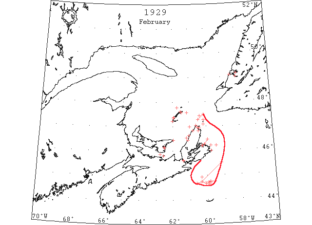
Feb Considerable field ice from the Gulf of St. Lawrence was reported from areas about midway between Sable Island and Cape Breton. (IIP p77)
Feb (early) Pilotage officer, Father Point: River clear of ice. (CIS IC0708_2)
Feb 1 Cape Race: Field ice covering large area 45°30’N 59°10’W to 44°45’N 60°20’W.[SS “Olaf Maersk” (HB)] (IIP p31#7)
Feb 1 “Stanley” was making slow progress down the NW coast of Cape Breton about 25 miles N of the icebound “Terne”. Extremely slow progress due to heavy ice. (Pat 1 Feb p1 c5)
Feb 2 Cape Race: Field ice 44°56’N 60°20’W. (IIP p31#8)
Feb 2 Sydney – Heavy close packed ice everywhere. Scatarie – Heavy open ice everywhere. Aspy Bay – Light close packed ice everywhere. St. Paul’s Island – No ice in sight. Amherst Island – One mile of shore ice. Old Harry – No ice in sight. (HH 02/02/1929 p23#1)
Feb 2 SS “Gripsholm” 44°56’N 60°20’W passing large quantities of drifting ice. (HB #2058 Feb 13)
Feb 2 Jan 21[?] “Stanley” 3/4 mile away from the “Tern” in 20 feet of thick ice. (Pat 8 Feb p5 c6)
Feb 4 Ice pans, sometimes ten feet thick and piled and frozen solid nearly twenty feet above the decks of the trapped steamer “Terne” have given away to the terrific battering of the government steamer “Stanley” and both vessels are now on their way to open water. The “Terne” had been a prisoner of the ice for thirteen days. On Sunday a line was placed aboard the “Terne” but the pressure of the ice was so great that it snapped and a second was stretched between the two vessels, which, according to latest word was still holding. With the Strait of Canso jammed with ice, Captain Bioret took the outside route around Cape North, only to be caught between Cheticamp and Margaree and forced within half a mile of the shore. The “Stanley” was able to go to her assistance after a difficult voyage of several days during which the government steamer was forced to buck heavy ice for a great part of the distance around Cape Breton Island. (HH 04/02/1929 p1; p4#4)
Feb 5 “Stanley” has moved the “Terne” ½ mile now in heavy rafted ice and waiting better conditions. (Pat 5 Feb p1 c2)
Feb 6 Cape Race: Pancake ice 44°40’N 60°37’W to 44°45’N 59°35’W. (IIP p31#9)
Feb 6 A patch of clear ice in the middle of the Arm was taken advantage of on Sunday afternoon for some of our young folks to have a skate. (TWS, p.2)
Feb 6 Scatari – Light close packed ice in shore, north. Aspy Bay, St. Paul’s Island – Light close packed ice distant, northwest. Amherst Island – Light close packed ice, stationary. Grosse isle – Light close packed ice distant, northwest. Old Harry- Light open ice in shore. (HH 06/02/1929 p11#2)
Feb 7 Sydney, Scatari – Light close packed everywhere. St. Paul’s Island – Light close packed distant north and west. Amherst Island, Etang du Nord – Light close packed ice everywhere. Grosse isle, Old Harry, Pleasant Bay – No ice in sight. (HH 07/02/1929 p11#3)
Feb 8 Aspy Bay – Light open ice distant. St. Paul’s Island – Heavy close packed ice distant, north and west. Pleasant Bay – Slob ice. Old Harry, Grosse isle – Light open ice, east; Amherst Island, Etang du Nord – Heavy close packed ice. (HH 08/02/1929 p13#6)
Feb 13 The SS “Caribou” reached North Sydney Thursday night. No ice is reported on her route excepting in Sydney Bight and since she has broken the bar the route is clear. (TWS, p.2).
Feb 13 The first iceboat for the season was out on Friday. (TWS, p.2).
Feb 13 A splendid sheet of ice covered the Humber Arm on Friday and Saturday, and many people took advantage of it for a skate. (TWS, p.2)
Feb 13 Sydney, Scatari – No ice in sight. Aspy Bay – No ice in sight. St. Paul’s Island – Light close packed ice distant along Cape Breton coast, extending northwest. Grosse Isle, Old Harry– Heavy close packed ice. Pleasant Bay – No ice in sight. Amherst Island – Light open ice in shore. (HH 13/02/1929 p11#1)
Feb 14 Cape Race: Field ice 44°45’N 59°50’W. (IIP p31#11)
Feb 14 Scatari – Light open ice distant north. Aspy Bay , St. Paul’s Island, no ice in sight Point Tupper – Light open ice off Tupper and Mulgrave. Cheticamp – Ice blocked on shore. Pictou Strait – Blocked with ice. Margaree – Ice blocked on shore. East Point – Heavy ice with ice conditions greatly improved. Pleasant Bay – No ice in sight. Old Harry- Heavy close packed ice distant. Grosse isle, Amherst Island, Etang du Nord – Heavy close packed ice. (HH 14/02/1929 p13#1)
Feb 14 A field of slob ice, 60 miles long, was sighted by the liner “Ryndam,” 40 miles north of Sable Island on Thursday. (HH 16/02/1929 p25#1)
Feb 15 Five miles off Cape North, the “Stanley” is battling with heavy arctic ice heading for Dingwall. (Pat 15 Feb p1 c1)
Feb 16 Sydney, Scatari, Cape Ray, Flat Point, Point Tupper – [no report of ice] Aspy Bay, St. Paul’s Island, Magdalen Islands – Light open ice everywhere. (HH 16/02/1929 p21#6)
Feb 17 Cape Race: Heavy field ice 44°41’N 59°49’W to 44°39’N 60°06’W [extending as far N as could be seen. (HB)] (IIP p31#13)
Feb 18 Ice conditions in the Strait have been favourable. (Pat 18 Feb p4 c3)
Feb 19 Panmure Island Lighthouse – very little ice in sight. Georgetown – ice in the harbour was only fit to busy (travel on) on the 19th. (Pat 21 Feb p6 c3)
Feb 20 Parties from Middle Arm inform us that the drift ice has filled the outer reaches of the Bay, and that Middle Arm is full of ice. (TWS, p.2)
Feb 20 Aspy Bay- No ice in sight. Point Tupper – Light open ice everywhere. St. Paul’s Island – Light close packed ice everywhere, northwest and south. Magdalen Islands – Light close packed ice everywhere. (HH 20/02/1929 p11#1)
Feb 22 Point Tupper – Open ice north and south. Scatari – Light open ice everywhere north. Aspy Bay – Light open ice distant. St. Paul’s Island – Light open ice distant along Cape Breton coast, extending northward. Old Harry, Pleasant Bay – Light open ice distant. Grosse isle– Light close packed in shore. (HH 22/02/1929 p11#1)
Feb 27 The “Caribou” reports seventy four miles of clear water on her last outward voyage to North Sydney, and the only ice on the run is centered on the Cape Breton coast. She took about twelve hours to butt her way into North Sydney. It is rather surprising that the Canadian Government ice breaker “Montcalm” ties up at Louisburg instead of helping to keep her ports open. The “Caribou” could have saved many hours had she been aided. (TWS, p.2)
Feb 27 Sydney, Scatari, Aspy Bay, St. Paul’s Island – Light north wind, clear. Sydney – Heavy close packed ice. Scatari, Aspy Bay – Heavy close packed ice distant. St. Paul’s Island – Heavy close packed ice everywhere. East Point – Ice moving southeast. Old Harry – No ice in sight. Pleasant Bay – Heavy open ice in shore. Grosse Isle, Amherst Island, Etang du Nord – Heavy close packed ice. (HH 27/02/1929 p11#1)
Feb 28 Sydney, Scatari – Heavy close packed ice everywhere. Aspy Bay – Heavy close packed ice distant. Point Tupper – Light open ice distant north and south. East Point – Ice moving southeast. St. Paul’s Island – Heavy close packed ice everywhere. Old Harry, Pleasant Bay – No ice in sight. Grosse isle, Etang du Nord – Heavy open ice everywhere. Amherst Island – Heavy close packed ice. (HH 28/02/1929 p13#1)
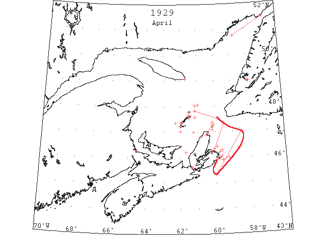
Apr Canadian ice patrol in the Gulf of St. Lawrence was inaugurated by the icebreaker “Miquela”. (IIP p6)
Apr No reports were received of the Gulf of St. Lawrence field ice. (IIP p78)
Apr 1 J.A. Ward, Lightkeeper, Miscou Point, New Brunswick: Opening date. (CIS IC0756_2)
Apr 1 Sydney, the CGS “Montcalm,” at a late hour tonight, was bucking her way through the ice fields that surround the Cape Breton coast in the vicinity of Scatari Island to go to the rescue of the sealer “Vedas” which today was stuck in the ice a short distance north of St. Paul’s. (HH 02/04/1929 p2#2)
Apr 3 Canso, no ice in sight. Grindstone, Magdalen Islands –Magdalen Islands surrounded with close packed drift ice. Pleasant Bay all clear. Only shore ice about two miles wide along Amherst Island shore. (HH 03/04/1929 p11#6)
Apr 6 Aspy Bay – heavy open ice distant. Heath Point – No ice in sight. Point Tupper – Scattered ice. St. Paul’s Island – Heavy open ice. Pleasant Bay- No ice in sight. Old Harry, Grosse Isle – Heavy open ice distant. Amherst Island, Etang du Nord – Heavy close packed ice. (HH 06/03/1929 p21#1)
Apr 10 Lightkeeper, East Point, PEI: Spring breakup. (CIS IC0993_2)
Apr 10 Grindstone, – Magdalen Islands surrounded with close packed drift ice. No water in sight westerly. Old Harry all but clear from there to Pleasant Bay. North Sydney – Heavy ice off coast. (HH 10/04/1929 p13#3)
Apr 11 Steamer “Caribou”: Left port au Basque, Nfld., 9:00 p.m. 10th, met heavy sheet ice 20 miles SW of Channel Head and held same to within 5 miles of Flat Point. Arrived North Sydney 9:00 a.m. 11th. (RG42 Vol.371)
Apr 11 Scatari – Heavy open ice distant. Aspy Bay – No ice in sight. Heath Point, no ice in sight. Point Tupper, open ice. St. Paul’s Island –Heavy close packed ice. Grosse Isle, Etang du Nord – Heavy close packed ice. Old Harry – Heavy open ice distant. (HH 11/04/1929 p13#3)
Apr 11 Grindstone, – Magdalen Islands surrounded on the north and western sides with close packed ice and no water in sight. All clear on southern side from East Point and Old Harry up into Pleasant Bay. (HH 1/04/1929 p13#5)
Apr 12 The steamer “Vedas” returned from the ice via North Sydney on Thursday morning. The “Vedas” sailed from Halifax on March 3rd for the ice via Louisburg; heavy ice was met with. (HH 12/04/1929 p13#3)
Apr 12 Heath Point – Heavy open ice. Point Tupper –Heavy close packed ice. Sydney, Scatarie, Aspy Bay, St. Paul Island, Magdalen Islands – Heavy open ice. (HH 12/04/1929 p13#1)
Apr 12 Grindstone, – Magdalen Islands surrounded on the north and western sides with close packed ice and no water in sight. All clear on southern side from East Point and Old Harry up into Pleasant Bay. (HH 12/04/1929 p13#4)
Apr 13 Scatarie – Heavy close packed ice northeast; passage clear. Aspy Bay – No ice in sight. Heath Point – No ice in sight. Point Tupper – Open ice. St. Paul Island – Heavy close packed ice. Old Harry – Open ice distant. Pleasant Bay – No ice in sight. (HH 13/04/1929 p23#2)
Apr 14 North Sydney, owing to the prevailing easterly winds the Cape Breton coast is packed with drift ice. The SS “Caribou,” which left here on her scheduled trip to Port aux Basques on Thursday night, was unable on her return to reach her dock at North Sydney yesterday, and was obliged to change her destination. This is the fourth time the “Caribou” had been forced to proceed to Louisburg on her tri-weekly visits, the three previous occasions having occurred in February. (HH 16/04/1929 p13#6)
Apr 15 The ice is now reported all gone from the north shore of the Island in most sections. Navigation in the Strait of Northumberland is open for the season. Ice remains in Shediac Bay but is weakening rapidly. (Pat 15 Apr p 8 c3)
Apr 16 Flat Point, heavy close packed ice everywhere. Sydney Harbour, heavy close packed ice everywhere. Scatari, heavy close packed ice everywhere. (HB # 2068 Apr 24)
Apr 16 The SS “Kamouraska” today began loading a 7,000 ton cargo of coal at Louisburg for the St. Lawrence market but it will be some days before she will be able to proceed to her destination on account of the heavy drift ice off the coast. (HH 16/04/1929 p3#8)
Apr 17 The “Caribou” arrived yesterday at 4 p.m. with a full cargo and discharging completed at 11:30 p.m. Capt. Tavernor reports very heavy loose ice. The prevailing northerly wind is shifting the ice out of the gulf. (TWS, p.2).
Apr 17 C. G. S. “Mikula” reports from 20 miles NE of St. Paul’s Island to Bird Rock, ice close packed but soft in places. Assisted Italian steamer between these positions. (NYMR, p.13, col.1)
Apr 17 Sydney, Scatarie – Heavy close packed ice everywhere. Heath Point – ice moving north. Point Tupper – Loose ice. (HH 17/04/1929 p13#1)
Apr 17-20 SS “Amaranto” for Montreal reached Father Point Apr. 17. 19th found heavy close packed ice all along the S side of Magdalens yesterday; N coast of Cape Breton clear water from shore to about midway between Cape Breton and Magdalens; heavy ice W of 46°12’N 61°41’W and clear water S but heavy close packed ice N as far as could be seen; 12 miles N of Bird Rock, heavy close packed ice as far as could be seen. 20th. 46°17’N 59°37’W heavy broken ice. (HB #2069 May 1)
Apr 18 Canadian Signal Service, H. S. McGreevy, Supt. reports ice as follows: Flat Point, heavy close packed ice; Scatari Island, heavy close packed ice. (NYMR, p.13, col.1).
Apr 18 Canadian patrol of Gulf discontinued. (RG42 Vol.371)
Apr 19 First arrival of season at Quebec. (WBB)
Apr 19 Old Harry, close packed ice. Etang du Nord, heavy open ice. St. Pauls Island, small broken sheet ice loosely packed everywhere in sight. Flat Point, heavy close packed ice distant. Scatari, heavy open ice everywhere. (HB #2069 May 1)
Apr 19 North Sydney, owing to the very heavy field of ice off the Cape Breton coast, the SS “Caribou” was unable to make Louisburg yesterday – a most unusual occurrence. However, yesterday afternoon a strong westerly wind eased the situation and she reached North Sydney early today. (HH 22/04/1929 p13#5)
Apr 19 Georgetown – work men getting the ferry boats for Georgetown – Newport ferry and Georgetown – Lower Montague ferry ready. We hope they will be running next week. (Pat 19 Apr p 7 c4)
Apr 19-24 Grosse Isle, open ice distant. (HB #2069 May 1)
Apr 20 St. Pauls Island, loose sheets of ice to the NE and S; long leads of open water extending to Cape Breton coast; close packed ice to W and NW. (HB #2069 May 1)
Apr 20 Sydney, four steamers are caught in the ice off Louisburg; as they have not sent out an SOS for help, it is thought the opening of the ice would soon get them clear an they would be able to reach Louisburg safely. (HH 20/04/1929 p3#4)
Apr 20 Canso, no ice in sight. Grindstone,– Magdalen Islands still surrounded with drift ice and Pleasant Bay is also full of ice. Port Hawksbury – Loose ice in sight. North Sydney – heavy ice in harbor and off coast. (HH 20/04/1929 p23#3)
Apr 20 Sydney Harbor – No ice in sight. Flat Point – Heavy close packed ice distant one mile moving to the east. Scatari – Heavy open ice everywhere. Aspy Bay – Heavy open ice everywhere. Point Tupper – Light open ice everywhere. St. Paul’s Island – Light close packed ice everywhere. Old Harry, Pleasant Bay – Heavy close packed ice. Grosse Isle, Etang du Nord – Heavy open ice everywhere. (HH 20/04/1929 p23#1)
Apr 22 Point Amour, heavy close packed ice everywhere; 1 berg. (HB #2069 May 1)
Apr 22 C.G.S. “Montcalm” light broken ice with occasional heavy pans and few leads 48°04’N 60°59’W. (HB #2069 May 1)
Apr 22 Georgetown – ferry running April 22nd (Pat 7 Apr 1934 p 7 c7)
Apr 23 Flat point, heavy close packed ice. (HB #2069 May 1)
Apr 24 The “Caribou” on Sunday’s run brought in seven live whitecoats. Capt. Tavernor reports very heavy ice jammed inside Low Point, and Sydney will not be reached again until there is a southerly wind. (TWS, p.2).
Apr 24 The ice in Cabot Strait last week so delayed the SS “Caribou” that there was no mail from Canada from Sunday until Saturday. (TWS, p.2).
Apr 24 The ice in Humber Arm is becoming bad at some places. On Saturday one horse broke through near Sprucy Point. Other broke through at several places between Curling and Corner Brook. (TWS, p.2)
Apr 24 Old Harry, open ice distant. Étang du Nord, heavy close packed ice. Scatari, heavy close packed ice. (HB #2069 May 1)
Apr 25 CGS “Mikula” from 8m SE of Scateri Is. to 46°N 59°14’W passed through heavy close packed ice. (NYMR)
Apr 25 Canadian Signal Service reports as follows: Magdalen Islands- Grosse Isle, about 4 miles of broken ice inshore; Old Harry and Amherst, open ice distant; Etang du Nord, heavy close packed ice; Pleasant Bay, scattered ice inshore; St. Paul’s Island, loose slob ice north and extending south to Cape Breton coast; Point Amour, heavy close packed ice everywhere; Belle Isle, heavy open ice everywhere; nineteen bergs and many growlers in sight. (NYMR, p.13, col.2).
Apr 25 “Bullmouth” (Br) reports from 45°20’N 60°00’W to 47°00’N 58°30’W, encountered considerable field ice. (NYMR, p.12, col.4)
Apr 25 SS “Bullmouth” 45°20’N 60°W to 47°N 58°30’W encountered considerable field ice. (HB #2072 May 22)
Apr 25 Louisburg: The ice-breaker “Mikula,” on ice patrol in the Gulf of St. Lawrence, reached port today towing the steamer “Imari” which lost her propeller while caught in a heavy ice field in the gulf. (HH 27/04/1929 p23#5)
Apr 26 Lightkeeper, East Point, PEI: Clear of ice. (CIS IC0993_3)
Apr 26 Sydney, Scatari, Flat Point – Heavy close packed ice. Aspy Bay – No ice in sight. Point Tupper – Slob ice northeast extending to Cape Breton coast; west no ice in sight. Grosse Isle, Pleasant Bay – Heavy close packed ice in shore. Old Harry, Etang du Nord – Heavy open ice distant. (HH 26/04/1929 p11#1)
Apr 27 Grindstone, – Magdalen Islands still surrounded with heavy drift ice from three to fifteen miles wide to north and northwest, but much wider to the westward. On south side drift ice at a distance. Pleasant Bay clear. (HH 27/04/1929 p23#6)
Apr 28 C.G.S. “Mikula” eastern edge of heavy pack in 46 21’N 58°41’W. (HB #2070 May 8)
Apr 29 Natashquan, from Mutton Bay to Point Amour, close packed ice everywhere. (HB #2070 May 8)
Apr 30 Etang du Nord, open ice distant. Pleasant Bay, scattered ice. Point Amour, heavy close packed ice everywhere. St. Pauls Island, loose ice breaking up to the S, W and N. (HB #2070 May 8)
Apr 30 Sydney, Scatari, Flat Point, Point Tupper – no ice in sight. Aspy Bay – no ice in sight. St. Paul’s Island – Slob ice east; scattered ice elsewhere. Etang du Nord, Grosse Isle, Old Harry, Amherst Island – Heavy open ice distant. (HH 30/04/1929 p17#1)
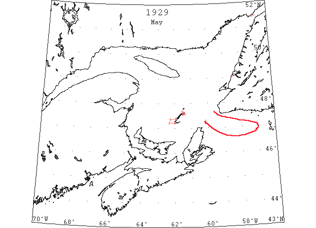
May Early in the month the two latest reports for the year were received of the Gulf of St. Lawrence field ice, both from the northern end of St. Pierre Bank. (IIP p79)
May 1 The “Caribou” made the longest trip for the winter this week having been 80 hours to Sydney. The S. W. winds yesterday have cleared the Cape Breton Coast and Friday’s run was made in 10 hours. (TWS, p.2).
May 1 The high wind of Monday night broke up the ice in Humber Arm. (TWS, p.2).
May 1 The SS “Corner Brook” was reported off Bay of Islands last Friday, in the ice. She is expected to reach port today. (TWS, p.2).
May 1 St. Paul’s Island reports broken ice today southwest, west, and northwest. (NYMR, p.13, col.2).
May 1 Point Amour reports heavy close packed ice everywhere. (NYMR, p.13, col.2).
May 1 Belle Isle reports heavy open ice everywhere; 15 bergs. (NYMR, p.13, col.2)
May 1 Grindstone, – Magdalen Islands surrounded by open drift ice about twelve miles wide at West Point and Etang du Nord narrowing down to about four miles at Grosse Isle and Old Harry. Water in sight all around Pleasant Bay clear. (HH 01/05/1929 p17#7)
May 4 46°51’N 57°11’W. Patches of scattered field ice. (IIP, P39 #457)
May 4 Grindstone, – Excepting a border of ice, in shore about two miles wide at West Point and Amherst Island, the Magdalen Islands are all clear of drift ice. (HH 02/05/1929 p4#4)
May 8 Canadian Signal Service reports ice sighted as follows: Point Amour, heavy close packed ice everywhere; two bergs in sight. (NYMR, p.12, col.4).
May 9 “Melita” 47°06’N 57°05’W several small pieces of field ice. (IIP p40)
May 15 Canadian Signal Service reports ice sighted as follows: Belle Isle, heavy open ice distant in Straits; and to the eastward, twenty-four bergs in sight. (NYMR, p.13, col.2).
May 22 Canadian Signal Service reports ice sighted as follows: Point Amour, heavy close packed ice everywhere; two bergs in sight; Belle Isle, heavy open ice distant in Strait; eight bergs in sight. (NYMR, p.13, col.2).
May 22 Word was received during the day from Cape Race that the Cabot Straits and the Gulf of St. Lawrence were clear of ice. (IIP p12)
May 31 Point Amour, heavy close packed ice everywhere; 3 bergs in sight. (HB #2075 Jun 12)
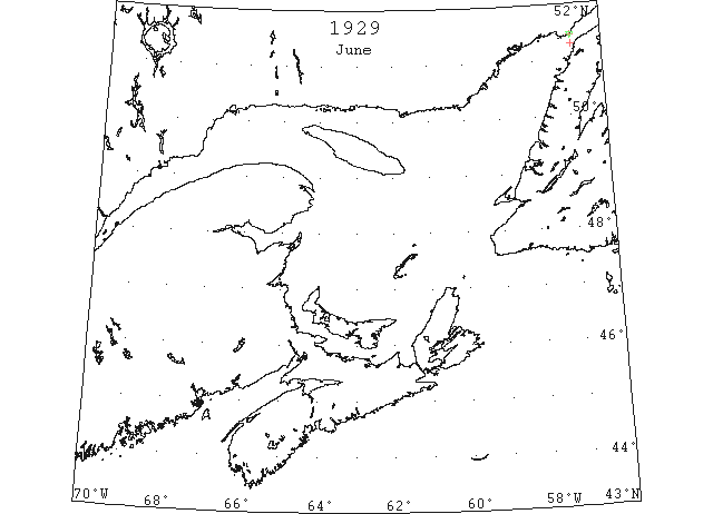
Jun 11 Point Amour, heavy open ice distant; heavy close packed ice inshore; 6 bergs in sight. (HB #2076 Jun 19)
Jun 17 Point Amour, heavy open ice everywhere; many bergs and growlers. (HB #2077 Jun 26)
Jun 20 “Hauerwijk” first vessel of the season through the Strait of Belle Isle. (RG42 Vol.371)
Jun 21 Point Amour, heavy open ice distant; many bergs and growlers. (HB #2078 Jul 3)
Jun 22 First Westbound steamer through the strait of Belle Isle. (WBB)
Jun 28 Point Amour, numerous bergs. (HB #2079 Jul 10)