1921
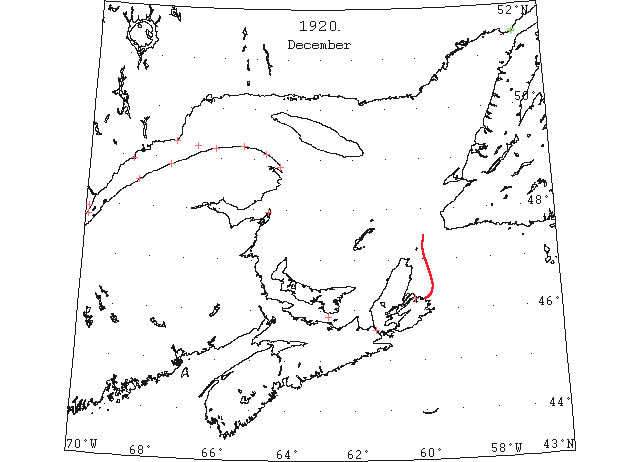
Dec 6 Last eastbound steamer through the Strait of Belle Isle. (WBB)
Dec 12 Last departure of the season from Quebec. (WBB)
Dec 17? Probably the last sailing vessels to leave any Island ports this fall are the schooner “Stathcona” plus five others awaiting a favourable chance to sail for Sydney. (Pat 17 Dec 1920 p 8#7)
Dec 18 Crane Island: [St. Lawrence] river covered with ice. Bersimis: slush ice about 1 mile wide moving with tide. Point Amour: two bergs. Belle Isle: two bergs. Montréal to Québec: very little ice in [St. Lawrence] river. (HB 1635 Jan 5 1921 CSS)
Dec 20 CGS “Stanley” will complete loading at Pictou for the Magdalene Islands today and will call at Souris. (Pat 20 Dec 1920 p 5#3)
Dec 20 The “Stanley” arrived in Souris December 20th. (Pat 24 Dec 1920 p 8#3)
Dec 20 Crane Island: no ice. Cape Salmon: light open ice everywhere. Montréal to Québec: very little ice. (HB 1635 Jan 5 1921 CSS)
Dec 21 Crane Island: no ice. Cape Salmon: light close-packed ice everywhere. Point Amour: slob ice inshore. Belle Isle: slob ice and light close-packed ice distant. Montréal to Québec: little ice on [St. Lawrence] river. (HB 1635 Jan 5 1921 CSS)
Dec 22 Cape Salmon: light close-packed ice everywhere. Father Point: slob ice inshore. Belle Isle: light close-packed ice distant. Sydney, N.S.: light close-packed ice everywhere. Montréal to Québec: light scattered ice on [St. Lawrence] river. (HB 1635 Jan 5 1921 CSS)
Dec 23 J.A. Ward, Lightkeeper, Miscou Point, New Brunswick: Closing date. (CIS IC0756_2)
Dec 23 Cape Salmon: light open ice distant. (HB 1635 Jan 5 1921 CSS)
Dec 24 Crane Island: considerable light open ice. L’Islet: open ice. Cape Salmon: considerable ice distant. Father Point: slob ice everywhere. Matane: light close-packed ice inshore. Montréal to Québec: light scattered ice passing down [St. Lawrence River]. (HB 1635 Jan 5 1921 CSS)
Dec 27 L’Islet: [St. Lawrence] river covered with ice. Cape Salmon: heavy open ice everywhere. Father Point: packed ice everywhere. Matane: heavy close-packed ice everywhere. Bersimis: heavy open ice everywhere. Rivière à la Martre: heavy close-packed ice everywhere. Fame Point: light open ice inshore. Cape Magdalen: light close-packed ice inshore. Point Tupper: light close-packed ice everywhere. (HB 1635 Jan 5 1921 CSS)
Dec 28 Crane Island: [St. Lawrence] river covered with ice. L’Islet: light open ice. Cape Salmon: heavy open ice everywhere. Matane: heavy close-packed ice everywhere. Bersimis: heavy open ice everywhere. Fame Point: light open ice everywhere. Cape Magdalen: light open ice everywhere. Belle Isle: slob ice and light close-packed ice distant. (HB 1635 Jan 5 1921 CSS)
Dec 29 The “Stanley” will leave Pictou tomorrow for Souris … and leave the same night for the Magdalene Islands. This is her last trip of the season. (Pat 28 Dec 1920 p 8#3)
Dec 29 Crane Island: [St. Lawrence] river covered with ice. L’Islet: [St. Lawrence] river covered with ice. Father Point: packed ice everywhere. Matane: heavy close-packed ice everywhere. Bersimis: thin sheet ice everywhere. Rivière à la Martre: light close-packed ice everywhere. Fame Point: light open ice everywhere. Cape Magdalen: light open ice everywhere. Cap des Rosiers: light open ice inshore. Pointe des Monts: light close-packed ice distant. Belle Isle: slob ice and light close-packed ice distant. (HB 1635 Jan 5 1921 CSS)
Dec 30 Passengers on the car ferry saw a deer trying to cross to the Island (on the ice). (Pat 30 Dec 1920 p 8#3)
Dec 30 Crane Island: [St. Lawrence] river covered with ice. Father Point: packed ice everywhere. Matane: heavy close-packed ice everywhere. Bersimis: heavy open ice everywhere. Rivière à la Martre: light open ice everywhere. Fame Point: light open ice everywhere. Cape Magdalen: light open ice everywhere. Cap des Rosiers: light open ice inshore. (HB 1635 Jan 5 1921 CSS)
Dec 31 Crane Island: [St. Lawrence] river covered with ice. L’Islet: open ice. Father Point: packed ice everywhere. Matane: heavy close-packed ice everywhere. Cap Chat: light open ice distant. Rivière à la Martre: light open ice everywhere. Cape Magdalen: light open ice everywhere. Fame Point: light open ice everywhere. Cap des Rosiers: light open ice inshore. Bersimis: heavy open ice everywhere. (HB 1636 Jan 12 1921 CSS)
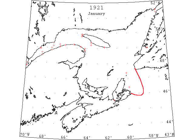
Jan 3 L’Islet: open ice. Cape Salmon: heavy open ice distant. Father Point: packed ice distant. Cap Chat: light open ice distant. Cape Magdalen: light open ice everywhere. Fame Point: light open ice everywhere. Southwest Point: light open ice inshore. (HB 1636 Jan 12 CSS)
Jan 5 Crane Island: not much ice. L’Islet: open ice. Cape Salmon: heavy close-packed ice inshore. Father Point: packed ice everywhere. Matane: heavy close-packed ice inshore. Cap Chat: light open ice distant. Rivière à la Martre: light open ice everywhere. Cape Magdalen: heavy open ice. Fame Point: heavy open ice everywhere. Pointe des Monts: light close-packed ice distant. Southwest Point: light open ice distant. Bersimis: heavy close-packed ice. Belle Isle: light open ice everywhere. Cape Salmon: heavy close-packed ice everywhere. Matane: heavy close-packed ice everywhere. Cap des Rosiers: light open ice distant. (HB 1637 Jan 19 CSS)
Jan 7 Crane Island: [St. Lawrence] river full of ice. L’Islet: open ice. Cape Salmon: heavy close-packed ice distant. Father Point: packed ice everywhere. Matane: heavy close-packed ice everywhere. Cap des Rosiers: light close-packed ice inshore. Bersimis: heavy close-packed ice everywhere. (HB 1637 Jan 19 CSS)
Jan 8 Crane Island: [St. Lawrence] river covered with ice. L’Islet: [St. Lawrence] river covered with ice. Cape Salmon: heavy close-packed ice everywhere. Father Point: packed ice everywhere. Matane: heavy open ice. Rivière à la Martre: light open ice everywhere. Cape Magdalen: heavy close-packed ice everywhere. Fame Point: heavy open ice everywhere. Cap des Rosiers: light open ice everywhere. Bersimis: heavy close-packed ice everywhere. Southwest Point: light open ice inshore. (HB 1637 Jan 19 CSS)
Jan 10 Crane Island: [St. Lawrence] river covered with ice. L’Islet: [St. Lawrence] river covered with ice. Cape Salmon: heavy close-packed ice distant. Father Point: packed ice everywhere. Matane: light open ice distant. Cap Chat: light open ice distant. Rivière à la Martre: light open ice everywhere. Cape Magdalen: heavy close-packed ice everywhere. Fame Point: heavy close-packed ice everywhere. Cap des Rosiers: light open ice distant. Bersimis: heavy close-packed ice everywhere. West Point: light close-packed ice everywhere. Southwest Point: light close-packed ice distant. (HB 1637 Jan 19 CSS)
Jan 11 Crane Island: open ice. L’Islet: open ice. Father Point: packed ice everywhere. Matane: heavy close-packed ice distant. Cap Chat: heavy open ice everywhere. Rivière à la Martre: heavy open ice everywhere. Fame Point: heavy open ice everywhere. Cap des Rosiers: heavy open ice everywhere. Bersimis: solid ice 2 miles off, no ice outside. Pointe des Monts: light open ice distant. Southwest Point: light open ice everywhere. Point Amour: light close-packed ice everywhere. Belle Isle: light close-packed ice inshore. (HB 1638 Jan 26 CSS)
Jan 12 Crane Island: [St. Lawrence] river covered with ice. L’Islet: open ice. Cape Salmon: heavy close-packed ice everywhere. Father Point: packed ice everywhere. Matane: heavy close-packed ice everywhere. Cap Chat: heavy close-packed ice everywhere. Cape Magdalen: heavy close-packed ice everywhere. Fame Point: heavy open ice everywhere. Bersimis: heavy close-packed ice everywhere. West Point: light close-packed ice everywhere. Southwest Point: light close-packed ice everywhere. (HB 1638 Jan 26 CSS)
Jan 13 Crane Island: light close-packed ice everywhere. L’Islet: light close-packed ice, stationary. Cape Salmon: heavy close-packed ice everywhere. Father Point: packed ice everywhere. Matane: heavy close-packed ice everywhere. Cap Chat: heavy close-packed ice everywhere. Rivière à la Martre: heavy close-packed ice everywhere. Cape Magdalen: heavy close-packed ice everywhere. Fame Point: heavy close-packed ice everywhere. Cap des Rosiers: light close-packed ice inshore. Pointe des Monts: light open ice everywhere. Southwest Point: light open ice distant. Point Amour: light close-packed ice everywhere. Belle Isle: light open ice everywhere. (HB 1638 Jan 26 CSS)
Jan 14 Crane Island: open ice. L’Islet: heavy close-packed ice. Cape Salmon: heavy close-packed ice everywhere. Father Point: packed ice everywhere. Matane: heavy close-packed ice everywhere. Cap Chat: heavy close-packed ice everywhere. Rivière à la Martre: heavy close-packed ice everywhere. Cape Magdalen: heavy close-packed ice everywhere. Fame Point: heavy close-packed ice everywhere. Cap des Rosiers: light close-packed ice everywhere. Bersimis: heavy close-packed ice everywhere. Pointe des Monts: light open ice distant. West Point: light close-packed ice everywhere. Southwest Point: light open ice inshore. Point Tupper: light ice. St. Paul Island: light ice in sight to north and northwest. Point Amour: light close-packed ice everywhere. Belle Isle: light close-packed ice inshore. (HB 1638 Jan 26 CSS)
Jan 15 Crane Island: light open ice. L’Islet: open ice. Cape Salmon: heavy open ice everywhere. Father Point: packed ice distant. Cap Chat: light open ice distant. Rivière à la Martre: heavy close-packed ice everywhere. Cape Magdalen: heavy open ice everywhere. Fame Point: heavy open ice everywhere. Cap des Rosiers: light open ice distant. Bersimis: heavy close-packed ice inshore. Pointe des Monts: heavy close-packed ice everywhere. Southwest Point: light close-packed ice everywhere. (HB 1638 Jan 26 CSS)
Jan 17 Cape Salmon: heavy close-packed ice everywhere. Father Point: packed ice everywhere. Cap Chat: light open ice distant. Rivière à la Martre: heavy open ice everywhere. Cape Magdalen: heavy close-packed ice everywhere. Fame Point: heavy open ice everywhere. Cap des Rosiers: light close-packed ice everywhere. Bersimis: close-packed ice everywhere. Pointe des Monts: heavy close-packed ice everywhere. Point Amour: light close-packed ice everywhere. Belle Isle: light close-packed ice inshore. (HB 1638 Jan 26 CSS)
Jan 18 Crane Island: [St. Lawrence] river covered with ice. L’Islet: light close-packed ice everywhere. Cape Salmon: heavy close-packed ice everywhere. Father Point: packed ice everywhere. Matane: heavy close-packed ice everywhere. Cap Chat: heavy close-packed ice everywhere. Rivière à la Martre: heavy close-packed ice everywhere. Cape Magdalen: heavy close-packed ice everywhere. Fame Point: heavy close-packed ice everywhere. Bersimis: close-packed ice everywhere. Southwest Point: light open ice inshore. Point Amour: light close-packed ice everywhere. Belle Isle: light close-packed ice everywhere. (HB 1638 Jan 26 CSS)
Jan 19 One of the ponies employed on Sat. hauling herring to the sable broke through the ice (Curling) about halfway from the wharf to the ship. Several other teams broke through closer to the shore. (TWS, pg. 2, Col. 2)
Jan 19 The SS “Sable” on Fri. had little difficulty in breaking the ice to A.E. Brake’s wharf in Meadows, and landing a quantity of freight for different parties. (TWS, pg. 2, Col. 3)
Jan 19 Crane Island: [St. Lawrence] river covered with ice. L’Islet: light close-packed ice, stationary. Cape Salmon: heavy close-packed ice everywhere. Father Point: packed ice everywhere. Matane: heavy close-packed ice everywhere. Rivière à la Martre: heavy close-packed ice everywhere. Cape Magdalen: heavy close-packed ice everywhere. Fame Point: heavy close-packed ice everywhere. Cap des Rosiers: light open ice inshore. Pointe des Monts: ice making fast, moving to southeast. West Point: North Channel, light close-packed ice everywhere, and South Channel, heavy open ice inshore. (HB 1638 Jan 26 CSS)
Jan 20 Crane Island: light close-packed ice everywhere. Cape Salmon: heavy open ice everywhere. Father Point: packed ice everywhere. Cape Magdalen: heavy close-packed ice everywhere. Fame Point: heavy close-packed ice everywhere. Cap des Rosiers: light open ice everywhere. Bersimis: close-packed ice everywhere. Pointe des Monts: light close-packed ice inshore. West Point: North Channel, light close-packed ice inshore. Point Tupper: strait full of ice. Point Amour: light close-packed ice everywhere. Belle Isle: light close-packed ice everywhere. (HB 1638 Jan 26 CSS)
Jan 21 Crane Island: light open ice. L’Islet: light open ice. Cape Salmon: heavy open ice everywhere. Father Point: packed ice everywhere. A schooner passed in the ice about 8 miles west, 6 miles from shore, slowly drifting eastward. Matane: heavy close-packed ice everywhere. Cap Chat: heavy close-packed ice everywhere. Rivière à la Martre: heavy open ice everywhere. Cape Magdalen: heavy close-packed ice everywhere. Fame Point: heavy close-packed ice everywhere. Cap des Rosiers: light open ice distant. Bersimis: heavy close-packed ice everywhere. Pointe des Monts: heavy close-packed ice inshore. Southwest Point: light close-packed ice everywhere. Point Amour: light close-packed ice everywhere. (HB 1639 Feb 2 CSS)
Jan 22 Crane Island: open ice. Cape Salmon: heavy open ice everywhere. Father Point: packed ice everywhere. A schooner in the ice 4 miles west, slowly drifting eastward. Matane: heavy open ice. Cap Chat: heavy close-packed ice everywhere. Rivière à la Martre: heavy close-packed ice everywhere. Cape Magdalen: heavy close-packed ice everywhere. Fame Point: heavy close-packed ice everywhere. Cap des Rosiers: light open ice distant, moving southward. West Point: light close-packed ice everywhere. North Shore: ice passed 2 miles off; clear outside. Southwest Point: light open ice distant. Point Tupper: loose ice. Point Amour: light close-packed ice everywhere. Belle Isle: light close-packed ice inshore. (HB 1639 Feb 2 CSS)
Jan 24 Crane Island: [St. Lawrence] river covered with ice. Father Point: packed ice everywhere. Matane: light close-packed ice everywhere. Cap Chat: light open ice distant. Rivière à la Martre: heavy close-packed ice everywhere. Cape Magdalen: heavy open ice everywhere. Fame Point: heavy close-packed ice everywhere. Cap des Rosiers: light close-packed ice everywhere. Bersimis: heavy close-packed ice everywhere. Pointe des Monts: heavy open ice distant, moving southwest. West Point: light close-packed ice everywhere. Point Amour: light close-packed ice everywhere, moving southeast. Belle Isle: light close-packed ice everywhere. (HB 1639 Feb 2 CSS)
Jan 25 Crane Island: [St. Lawrence] river covered with ice. Cape Salmon: heavy close-packed ice distant. Father Point: packed ice everywhere. Matane: heavy close-packed ice everywhere. Cap Chat: heavy close-packed ice everywhere. Rivière à la Martre: heavy close-packed ice everywhere. Cape Magdalen: heavy close-packed ice everywhere. Fame Point: heavy close-packed ice everywhere. Cap des Rosiers: light close-packed ice everywhere. Bersimis: heavy close-packed ice everywhere. Pointe des Monts: heavy open ice distant, moving southwest. West Point: light close-packed ice everywhere. Point Tupper: light open ice everywhere. Point Amour: light close-packed ice everywhere. (HB 1639 Feb 2 CSS)
Jan 26 Parties from outer part of the Bay yesterday told us that there was no sign of drift ice off Bay of Islands yet this season. (TWS, pg. 2, Col. 1)
Jan 26 L’Islet: heavy close-packed ice. Cape Salmon: heavy close-packed ice distant. Father Point: heavy close-packed ice everywhere. Cap Chat: heavy close-packed ice everywhere. Rivière à la Martre: heavy close-packed ice everywhere. Cape Magdalen: heavy close-packed ice everywhere. Fame Point: heavy close-packed ice everywhere. Cap des Rosiers: light open ice everywhere, moving south. Bersimis: heavy close-packed ice everywhere. Pointe des Monts: heavy open ice distant, moving southwest. West Point: light close-packed ice everywhere. Southwest Point: light open ice everywhere. Point Tupper: strait full of ice. Point Amour: light close-packed ice distant. Belle Isle: light close-packed ice everywhere. (HB 1639 Feb 2 CSS)
Jan 27 Crane Island: considerable ice. Father Point: packed ice distant. Matane: ice moving to the northward. Cap Chat: heavy close-packed ice everywhere. Rivière à la Martre: heavy close-packed ice everywhere. Cape Magdalen: heavy close-packed ice everywhere. Fame Point: heavy close-packed ice everywhere. Cap des Rosiers: light open ice inshore, moving southeast. Bersimis: heavy close-packed ice everywhere. West Point: light close-packed ice everywhere. South Point: light close-packed ice everywhere. Point Amour: light close-packed ice everywhere. Belle Isle: light open ice everywhere. Scatari: ice making fast. (HB 1639 Feb 2 CSS)
Jan 28 Scatari, ice making fast. Point Amour, light close packed ice everywhere. (HB 1640 Feb 9)
Jan 28 Crane Island: light open ice. L’Islet: heavy close-packed ice everywhere. Cape Salmon: heavy close-packed ice everywhere. Father Point: close-packed ice everywhere. Matane: heavy close-packed ice everywhere. Cap Chat: heavy close-packed ice everywhere. Rivière à la Martre: heavy close-packed ice everywhere. Fame Point: heavy close-packed ice everywhere. Cap des Rosiers: light open ice everywhere. North Shore: heavy close-packed ice everywhere. Pointe des Monts: heavy close-packed ice distant. Southwest Point: light open ice distant. South Point: light open ice everywhere. Point Tupper: loose ice. (HB 1640 Feb 9 CSS)
Jan 29 Scatari, light close packed ice inshore. Point Amour, light close packed ice everywhere. (HB 1640 Feb 9)
Jan 29 Crane Island: very little ice. L’Islet: open ice. Cape Salmon: heavy open ice everywhere. Father Point: heavy close-packed ice distant, clear inshore. Matane: heavy close-packed ice everywhere. Cap Chat: heavy open ice distant. Rivière à la Martre: heavy close-packed ice everywhere. Fame Point: heavy close-packed ice everywhere. Cap des Rosiers: light open ice everywhere. North Shore: heavy close-packed ice everywhere. Southwest Point: light close-packed ice inshore. South Point: light close-packed ice everywhere. (HB 1640 Feb 9 CSS)
Jan 31 Flat Point, light open ice distant. Scatari, light open ice. (HB 1640 Feb 9)
Jan 31 The only steamship arrival yesterday was the Farquhar line steamer “Sable I.” from St. John’s Nfld, she was 4 days steaming through ice off Scatterie, but from there to port had a good run. (HH 31/01/1921 p11 #7)
Jan 31 Crane Island: [St. Lawrence] river covered with thin ice. L’Islet: light close-packed ice everywhere. Cape Salmon: heavy open ice everywhere. Father Point: packed ice everywhere. Matane: heavy close-packed ice everywhere. Cap Chat: heavy open ice distant. Rivière à la Martre: heavy close-packed ice everywhere. Fame Point: heavy close-packed ice everywhere. North Shore: heavy close-packed ice everywhere. Pointe des Monts: ice moving southeast. West Point: light close-packed ice everywhere. South Point: light close-packed ice everywhere. Point Tupper: loose ice. Cape Ray: ice making fast. (HB 1640 Feb 9 CSS)
Jan 31? Cap des Rosiers: light close-packed ice everywhere. (HB 1640 Feb 9 CSS)
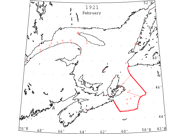
Feb 1 Flat Point, light close packed ice everywhere, stationary. Point Amour, light close packed ice everywhere. (HB 1640 Feb 9)
Feb 1 Crane Island: considerable light open ice. L’Islet: [St. Lawrence] river covered with vapor. Cape Salmon: heavy open ice everywhere. Father Point: packed ice everywhere. Matane: heavy close-packed ice everywhere. Rivière à la Martre: heavy close-packed ice everywhere. Fame Point: heavy close-packed ice everywhere. Cap des Rosiers: heavy close-packed ice everywhere. North Shore: heavy close-packed ice everywhere. Pointe des Monts: heavy close-packed ice distant. West Point: North Channel, heavy close-packed ice everywhere; and South Channel, light close-packed ice inshore. Southwest Point: light close-packed ice distant. South Point: light close-packed ice everywhere. Point Tupper: strait clear. (HB 1640 Feb 9 CSS)
Feb 2 Ice has been reported as follows: 45°20’N 59°36’W, passed through field ice. (HB 1641 Feb 16)
Feb 2 Crane Island: open ice. Cape Salmon: heavy close-packed ice everywhere. Father Point: packed ice everywhere. Matane: heavy close-packed ice everywhere. Cap Chat: heavy close-packed ice everywhere. Rivière à la Martre: heavy close-packed ice everywhere. Cape Magdalen: heavy close-packed ice everywhere. Fame Point: heavy close-packed ice everywhere. Cap des Rosiers: heavy close-packed ice everywhere. North Shore: heavy close-packed ice everywhere. West Point: light close-packed ice inshore. Southwest Point: light close-packed ice distant. South Point: light loose-packed ice everywhere. Point Tupper: Strait clear. Flat Point: light close-packed ice distant, moving east. Scatari: heavy close-packed ice everywhere, stationary. Point Amour: light close-packed ice everywhere. Belle Isle: heavy close-packed ice everywhere. Four icebergs. (HB 1641 Feb 16 CSS)
Feb 3 Crane Island: open ice. L’Islet: light open ice. Cape Salmon: heavy close-packed ice everywhere. Father Point: packed ice distant, open water inshore. Matane: light open ice. Cap Chat: light open ice distant. Rivière à la Martre: heavy close-packed ice distant. Cape Magdalen: heavy close-packed ice everywhere. Fame Point: heavy close-packed ice everywhere. Cap des Rosiers: heavy close-packed ice everywhere. West Point: heavy close-packed ice inshore. Southwest Point: light close-packed ice distant. Point Tupper: Strait clear. Cape Ray: light open ice everywhere. Flat Point: light close-packed ice everywhere, stationary. Scatari: heavy open ice everywhere. Point Amour: light close-packed ice everywhere. (HB 1641 Feb 16 CSS)
Feb 4 Crane Island: very little ice. L’Islet: light open ice. Cap Chat: heavy open ice everywhere. Rivière à la Martre: heavy open ice everywhere. Cape Magdalen: heavy close-packed ice everywhere. Fame Point: heavy close-packed ice everywhere. Cap des Rosiers: heavy close-packed ice everywhere. North Shore: heavy close-packed ice everywhere. Southwest Point: light close-packed ice everywhere. South Point: light open ice inshore. Point Tupper: Strait clear. Flat Point: light close-packed ice everywhere, stationary. Scatari: heavy close-packed ice everywhere, stationary. Point Amour: light close-packed ice everywhere. Belle Isle: heavy close-packed ice everywhere. Four icebergs. (HB 1641 Feb 16 CSS)
Feb 5 Crane Island: light open ice. L’Islet: light open ice. Father Point: packed ice everywhere. Matane: light open ice distant. Cap Chat: open ice everywhere. Rivière à la Martre: heavy open ice everywhere. Cape Magdalen: heavy close-packed ice everywhere. Fame Point: heavy close-packed ice everywhere. Cap des Rosiers: heavy close-packed ice everywhere. North Shore: heavy close-packed ice everywhere. West Point: light close-packed ice everywhere. Southwest Point: light close-packed ice everywhere. South Point: light open ice inshore. Point Tupper: Strait clear. Flat Point: light close-packed ice everywhere, stationary. Scatari: heavy open ice inshore. Point Amour: light close-packed ice everywhere. Belle Isle: heavy close-packed ice everywhere; four icebergs. (HB 1641 Feb 16 CSS)
Feb 6 Ice has been reported as follows: 45°30’N 58°50’W, large fields of sludge ice. (HB 1646 Mar 23)
Feb 7 Crane Island: light open ice. L’Islet: light open ice. Cape Salmon: heavy close-packed ice everywhere. Father Point: packed ice everywhere. Matane: packed ice everywhere. Cap Chat: packed ice everywhere. Rivière à la Martre: heavy open ice everywhere. Cape Magdalen: heavy close-packed ice everywhere. Fame Point: heavy close-packed ice everywhere. Cap des Rosiers: heavy close-packed ice everywhere. North Shore: packed ice distant. Point des Monts: light close-packed ice everywhere. West Point: North Channel, light close-packed ice everywhere; South Channel, heavy open ice inshore. Southwest Point: no ice in sight. Point Tupper: strait clear. Flat Point: heavy close-packed ice everywhere, stationary. Scatari: heavy close-packed ice everywhere. Point Amour: light close-packed ice everywhere, moving west. Belle Isle: light close-packed ice everywhere. (HB 1642 Feb 23 CSS)
Feb 7 Ice has been reported as follows: 44°50’N 55°20’W, a large field of sludge ice. (HB 1646 Mar 23)
Feb 8 Crane Island: open ice everywhere. L’Islet: light close-packed ice everywhere. Cape Salmon: heavy close-packed ice everywhere. Father Point: packed ice everywhere. Matane: heavy close-packed ice everywhere. Cap Chat: heavy close-packed ice everywhere. Rivière à la Martre: heavy open ice everywhere. Cape Magdalen: heavy close-packed ice everywhere. Fame Point: heavy close-packed ice everywhere. Cap des Rosiers: heavy close-packed ice everywhere. West Point: heavy open ice westward. Southwest Point: no ice in sight. Point Tupper: strait clear. Flat Point: heavy close-packed ice everywhere. Scatari: heavy close-packed ice everywhere. (HB 1642 Feb 23 CSS)
Feb 9 Teams from Middle Arm were here (Meadows) for the first time this season by ice on Fri. (TWS, p. 2, Col. 4)
Feb 9 The “Kyle” was unable to reach North Sydney on her last Thur.’s trip owing to ice, and had to go to Louisburg. (TWS, pg. 3, Col. 5)
Feb 9 The harbor (Lark Harbor) is now frozen over, and the drift ice is visible from shore, and it looks as though it is going to remain for a while. (TWS, pg. 3, Col. 5)
Feb 9 Crane Island: considerable light open ice. L’Islet: light close-packed ice everywhere. Cape Salmon: heavy close-packed ice everywhere. Father Point: packed ice everywhere. Matane: heavy close-packed ice everywhere. Cap Chat: heavy close-packed ice everywhere. Rivière à la Martre: heavy close-packed ice everywhere. Cape Magdalen: heavy close-packed ice everywhere. Fame Point: heavy close-packed ice everywhere. Cap des Rosiers: heavy close-packed ice everywhere. North Shore: heavy close-packed ice everywhere. Point des Monts: open ice everywhere, moving east. West Point: North Channel, no ice in sight; South Channel, light close-packed ice everywhere. Southwest Point: light open ice everywhere. Point Tupper: strait clear. Flat Point: heavy close-packed ice everywhere. Scatari: heavy close-packed ice everywhere. (HB 1642 Feb 23 CSS)
Feb 10 North Sydney, while ice occurring off the coast as originally formed is not heavy the rafted the ice heavily to a pieces [sic] has created difficult conditions, and in some instances the ice projects 14 ft out of the water. Prevailing winds have rafted ice heavily to a distance of about 4 miles out. Beyond this ice is everywhere extending out to Nfld. (HH 10/02/1921 p1 #3)
Feb 10 Crane Island: open ice. L’Islet: open ice. Cape Salmon: heavy open ice everywhere. Father Point: packed ice distant, open water inshore. Matane: heavy close-packed ice everywhere. Cap Chat: broken ice. Rivière à la Martre: heavy close-packed ice everywhere. Cape Magdalen: heavy close-packed ice everywhere. Fame Point: heavy close-packed ice everywhere. Cap des Rosiers: heavy close-packed ice inshore. North Shore: heavy close-packed ice everywhere. West Point: light close-packed ice everywhere; South Channel, heavy open ice. Southwest Point: light close-packed ice everywhere. Point Tupper: strait clear. Flat Point: heavy close-packed ice everywhere. Scatari: heavy close-packed ice everywhere, stationary. Point Amour: heavy close-packed ice everywhere. (HB 1642 Feb 23 CSS)
Feb 11 Crane Island: light open ice. Cape Salmon: heavy close-packed ice everywhere. Father Point: close-packed ice everywhere. Matane: close-packed ice everywhere. Cap Chat: heavy close-packed ice everywhere. Rivière à la Martre: heavy close-packed ice everywhere. Cape Magdalen: heavy close-packed ice everywhere. Fame Point: heavy close-packed ice everywhere. Cap des Rosiers: heavy close-packed ice everywhere. North Shore: heavy close-packed ice everywhere. Southwest Point: light open ice everywhere. Point Tupper: strait clear. Flat Point: heavy close-packed ice everywhere, moving southeast. Point Amour: heavy close-packed ice everywhere. (HB 1642 Feb 23 CSS)
Feb 12 Crane Island: light open ice. L’Islet: light open ice everywhere. Cape Salmon: heavy close-packed ice distant. Father Point: close-packed ice everywhere. Matane: heavy close-packed ice everywhere. Cap Chat: heavy close-packed ice everywhere. Rivière à la Martre: heavy open ice everywhere. Cape Magdalen: heavy close-packed ice everywhere. Fame Point: heavy close-packed ice everywhere. Cap des Rosiers: heavy close-packed ice everywhere. North Shore: heavy close-packed ice everywhere. West Point: North Channel, light close-packed ice everywhere; South Channel, no ice in sight. Southwest Point: no ice in sight. Point Tupper: strait clear. Scatari: heavy close-packed ice inshore, moving northeast. (HB 1642 Feb 23 CSS)
Feb 13 Ice has been reported as follows: 45°28’N 58°18’W, entered field ice and steamed through it until Feb 14, 45°49’N 59°28’W, when it became too heavily packed to proceed further. (HB 1643 Mar 2 CSS)
Feb 14 Cape Ray, light open ice everywhere. Flat Point, heavy close packed ice distant. Scatari, heavy close packed ice everywhere. (HB #1643 Mar 2)
Feb 14 Father Point: packed ice everywhere. Matane: heavy close-packed ice everywhere. Cap Chat: heavy close-packed ice everywhere. Rivière à la Martre: heavy close-packed ice everywhere. Cape Magdalen: heavy close-packed ice everywhere. Fame Point: heavy close-packed ice everywhere. Cap des Rosiers: heavy close-packed ice everywhere. Cap d’Espoir: heavy close-packed ice distant. North Shore: heavy close-packed ice distant. West Point: North Channel: light close-packed ice everywhere. South Channel: heavy open ice everywhere. South Point: light close-packed ice everywhere. Crane Island: open ice. Cape Salmon: heavy close-packed ice distant. (HB 1643 Mar 2 CSS)
Feb 15 Point Tupper, loose ice. Flat Point, heavy close packed ice everywhere stationary. . Scatari, heavy close packed ice everywhere. (HB #1643 Mar 2)
Feb 15 The ocean off the Cape Breton coast is packed with ice as far as the eye can see. The steamer “Lady Laurier” was at Whitehead yesterday en route east. She encountered lots of ice. (HH 16/02/1921 p11#8)
Feb 15 Father Point: packed ice everywhere. Matane: heavy close-packed ice everywhere. Cap Chat: heavy close-packed ice everywhere. Rivière à la Martre: heavy close-packed ice everywhere. Cape Magdalen: heavy close-packed ice everywhere. Fame Point: heavy close-packed ice everywhere. Cap des Rosiers: heavy close-packed ice everywhere. North Shore: heavy close-packed ice everywhere. West Point: North Channel: light close-packed ice everywhere. South Channel: heavy open ice everywhere. Crane Island: considerable open ice. L’Islet: open ice. Cape Salmon: heavy open ice everywhere. (HB 1643 Mar 2 CSS)
Feb 16 There is now good walking on Bonne Bay. (TWS, pg. 2, Col. 4)
Feb 16 Point Tupper, loose ice. Flat Point, heavy close packed ice distant. (HB #1643 Mar 2)
Feb 16 Thirty-six hours late the steamer “Pro Patria” arrived from St. Pierre yesterday afternoon. She had a rough trip and besides was detained on account of ice conditions off the Cape Breton coast. (HH 17/02/1921 p11#7)
Feb 16 Father Point: packed ice everywhere. Matane: heavy close-packed ice everywhere. Cap Chat: heavy open ice, stationary. Rivière à la Martre: heavy close-packed ice everywhere. Cape Magdalen: heavy close-packed ice everywhere. Fame Point: heavy close-packed ice everywhere. Bersimis: heavy close-packed ice everywhere. West Point: North Channel: light close-packed ice everywhere. South Channel: no ice in sight. South Point: light close-packed ice everywhere. Crane Island: considerable ice. L’Islet: open ice. (HB 1643 Mar 2 CSS)
Feb 17 Flat Point, heavy close packed ice distant. (HB #1643 Mar 2)
Feb 17 The ice in the Gulf is still very heavy and the Magdalen Islands are reported to be completely surrounded and cut off by heavy floes from all communication by steamer from the outside world. (HH 17/02/1921 p11#4)
Feb 17 Father Point: packed ice everywhere. Matane: heavy open ice inshore. Cap Chat: heavy close-packed ice distant. Rivière à la Martre: heavy open ice everywhere. Cape Magdalen: heavy open ice everywhere. Fame Point: heavy open ice everywhere. Cap des Rosiers: heavy close-packed ice inshore, heavy open ice distant. Bersimis: heavy close-packed ice everywhere. West Point: North Channel: heavy open ice. South Channel: light open ice inshore. Southwest Point: light close-packed ice everywhere. L’Islet: open ice. (HB 1643 Mar 2 CSS)
Feb 18 “Stanley” coaled today at the Scotia pier for Louisburg, where she will engage in breaking passage for steamers out of that port. Ice is p[ack]ed heavily all along the coast much of it rafted 5 to 8 feet out of water. It has opened very slightly and westerly wind is needed to clear the coast. (HH 9/02/1921 p19#6)
Feb 18 Father Point: packed ice everywhere. Matane: heavy close-packed ice everywhere. Cap Chat: heavy close-packed ice everywhere. Rivière à la Martre: heavy packed ice everywhere. Cape Magdalen: heavy close-packed ice everywhere. Fame Point: heavy close-packed ice everywhere. Cap des Rosiers: heavy close-packed ice inshore. Bersimis: heavy close-packed ice everywhere. West Point: North Channel: light close-packed ice everywhere. South Channel: light close-packed ice inshore. Southwest Point: light open ice distant. South Point: light open ice inshore. Crane Island: [St. Lawrence] river covered with ice. L’Islet: light close-packed ice everywhere. Cape Salmon: heavy close-packed ice distant. (HB 1643 Mar 2 CSS)
Feb 19 Flat Point, heavy close packed ice everywhere moving SE. (HB #1643 Mar 2)
Feb 19 Father Point: packed ice everywhere. Matane: heavy close-packed ice everywhere. Cap Chat: heavy close-packed ice everywhere. Rivière à la Martre: heavy close-packed ice everywhere. Cape Magdalen: heavy open ice distant. Fame Point: heavy open ice everywhere. Cap des Rosiers: heavy close-packed ice, stationary. Bersimis: heavy close-packed ice inshore. West Point: light close-packed ice everywhere. Southwest Point: heavy close-packed ice everywhere. South Point: heavy close-packed ice everywhere. Crane Island: [St. Lawrence] river covered with heavy ice. Cape Salmon: heavy open ice everywhere. (HB 1643 Mar 2 CSS)
Feb 19 Ice has been reported as follows: 45°42’N 57°40’W, heavy slob ice, checked to half speed. (HB 1649 Apr 13)
Feb 20 Ice has been reported as follows: 45°21’N 59°15’W, stuck in solid ice, unable to make any headway, ice drifting to the south and east. (HB 1649 Apr 13)
Feb 21 Issue: SS “Delco” from Gothenburg via St. John’s for New York was caught in the ice off Louisburg for ~1 week. (NYMR)
Feb 21 Flat Point, heavy close packed ice everywhere. Scatari, heavy close packed ice everywhere. (HB #1643 Mar 2)
Feb 21 Father Point: packed ice everywhere. Matane: heavy close-packed ice everywhere. Cap Chat: heavy close-packed ice everywhere. Rivière à la Martre: heavy close-packed ice everywhere. Cape Magdalen: heavy close-packed ice everywhere. Fame Point: heavy close-packed ice everywhere. Cap des Rosiers: heavy close-packed ice everywhere. Bersimis: light ice packed everywhere. Southwest Point: heavy open ice distant. South Point: heavy open ice inshore. Crane Island: [St. Lawrence] river covered with light ice. Cape Salmon: heavy close-packed ice distant. (HB 1643 Mar 2 CSS)
Feb 21 Ice has been reported as follows: 45°02’N 59°37’W, stopped in solid ice, no headway. (HB 1650 Apr 20)
Feb 22 Flat Point, heavy close packed ice everywhere moving SE. Scatari, heavy close packed ice everywhere stationary. (HB #1643 Mar 2)
Feb 22 The steamer “Sable I,” arrived from St. John’s, Nfld. Off the Cape Breton coast, the ship steamed through sixty miles of slob ice. (HH 23/02/1921 p11#7)
Feb 22 Father Point: packed ice distant, clear open water inshore. Matane: light open ice distant. Cap Chat: heavy open ice everywhere. Rivière à la Martre: heavy close-packed ice everywhere. Cape Magdalen: heavy close-packed ice everywhere. Fame Point: heavy open ice everywhere. Cap des Rosiers: heavy close-packed ice everywhere. Bersimis: heavy open ice. West Point: heavy close-packed ice everywhere. Southwest Point: heavy close-packed ice everywhere. South Point: light close-packed ice everywhere. L’Islet: open ice. Cape Salmon: heavy close-packed ice everywhere. (HB 1643 Mar 2 CSS)
Feb 22 Ice has been reported as follows: 44°46’N 60°32’W, clear of ice. (HB 1649 Apr 13)
Feb 22 Ice has been reported as follows: 44°40’N 58°39’W to 44°32’N 60°15’W, field ice to northward. From the latter position to Cape Canso, sludge ice. Pack ice all along the Cape Breton and Nova Scotia coasts. The body of the ice seemed to be moving in a southwesterly direction. (HB 1649 Apr 13)
Feb 23 Tack’s Beach [Placentia Bay?](Feb 18)- 2 men are missing from here. It is feared they have fallen through the ice
There was very good skating on the Humber Arm ice last week. (TWS, pg. 4, Col. 3) [NOTE: Bottom half of pages 3 & 4 are missing]
Feb 23 Cape Ray, heavy close packed ice distant. Flat Point, heavy close packed ice everywhere moving SE Scatari, heavy close packed ice everywhere stationary. (HB #1643 Mar 2)
Feb 23 Matane: heavy open ice inshore, moving north. Cap Chat: heavy open ice everywhere. Rivière à la Martre: heavy open ice everywhere. Cape Magdalen: heavy close-packed ice everywhere. Fame Point: heavy close-packed ice everywhere. Cap des Rosiers: heavy close-packed ice inshore, heavy open ice distant. Bersimis: open ice 1 mile off, moving south. West Point: North Channel: light open ice inshore. South Channel: heavy open ice everywhere. Southwest Point: heavy close-packed ice everywhere. South Point: heavy close-packed ice everywhere. Crane Island: open ice. Cape Salmon: heavy close-packed ice distant. (HB 1643 Mar 2 CSS)
Feb 24 West Point, heavy close packed ice everywhere. (HB #1644 Mar 9)
Feb 24 Cape Salmon: heavy close-packed ice distant. Father Point: open ice. Matane: heavy close-packed ice everywhere. Cap Chat: heavy open ice everywhere. Rivière à la Martre: heavy close-packed ice inshore. Cape Magdalen: heavy open ice everywhere. Fame Point: heavy close-packed ice inshore. Cap des Rosiers: heavy open ice everywhere. Bersimis: heavy open ice everywhere. Point des Monts: ice moving eastward. Southwest Point: light close-packed ice everywhere. Point Tupper: scattered ice. Flat Point: heavy close-packed ice distant. East Scatari: heavy open ice. (HB 1644 Mar 9 CSS)
Feb 25 West Point North Channel westward, light open ice distant. (HB #1644 Mar 9)
Feb 25 L’Islet: light open ice. Crane Island: [St. Lawrence] river covered with open ice. Cape Salmon: heavy close-packed ice distant. Father Point: close-packed ice everywhere. Matane: heavy close-packed ice everywhere. Cap Chat: heavy close-packed ice everywhere. Rivière à la Martre: heavy close-packed ice everywhere. Cape Magdalen: heavy close-packed ice everywhere. Fame Point: heavy close-packed ice everywhere. Cap des Rosiers: heavy close-packed ice everywhere. Bersimis: heavy close-packed ice everywhere. Point des Monts: heavy close-packed ice distant. Southwest Point: heavy close-packed ice distant. Point Tupper: strait clear. Flat Point: heavy close-packed ice distant, moving south. East Scatari: heavy open ice everywhere, moving south. Point Amour: heavy close-packed ice everywhere, moving east. Belle Isle: heavy open ice everywhere, five bergs. (HB 1644 Mar 9 CSS)
Feb 26 West Point North Channel` heavy close packed ice everywhere; South Channel, light open ice everywhere (HB #1644 Mar 9)
Feb 26 The French three masted schooner “Mousquetaire,” is stuck in the ice twenty eight miles off Louisburg. (HH 28/02/1921 p11#1)
Feb 26 L’Islet: open ice. Crane Island: open ice. Cape Salmon: heavy close-packed ice distant. Father Point: packed ice everywhere. Matane: heavy close-packed ice moving west. Cap Chat: heavy open ice everywhere. Rivière à la Martre: heavy open ice. Cape Magdalen: heavy open ice distant. Fame Point: heavy close-packed ice everywhere. Cap des Rosiers: heavy close-packed ice everywhere, moving west. Bersimis: heavy open ice everywhere. Southwest Point: heavy open ice everywhere. Point Tupper: strait clear. Flat Point: heavy close-packed ice distant, moving southeast. East Scatari: heavy close-packed ice everywhere, heavy close-packed ice stationary. (HB 1644 Mar 9 CSS)
Feb 27 The steamer “J L Nelson” made an attempt yesterday to go to Prospect and Terrance bay. The “Nelson” found the whole coast a mass of ice, in some places almost solid and there was a very heavy sea running outside, it being impossible for several larger steamers to continue their voyages. The “Nelson” put into Sambro and then returned to Halifax, arriving back late in the evening and encountered much difficulty in getting into the harbor on account of the ice which, however, did not interfere with the larger craft. The conditions must have been pretty bad when Capt. Wrayton was forced to give up the fight. (HH 28/02/1921 p15#7)
Feb 28 West Point North Channel, light open ice inshore; South Channel, heavy close packed ice everywhere. (HB #1644 Mar 9)
Feb 28 Ice conditions are delaying the arrival of the steamer “Coban,” and the barge “Laugen,” both from Louisburg. (HH 28/02/1921 p15#8)
Feb 28 Crane Island: open ice. Cape Salmon: heavy open ice everywhere. Matane: heavy open ice everywhere. Cap Chat: heavy open ice distant. Rivière à la Martre: heavy open ice everywhere. Cape Magdalen: heavy close-packed ice distant. Fame Point: heavy open ice everywhere. Cap des Rosiers: heavy close-packed ice everywhere, heavy open ice distant. Southwest Point: heavy close-packed ice everywhere. Point Tupper: strait clear. Flat Point: heavy close-packed ice distant. East Scatari: heavy close-packed ice everywhere. Point Amour: heavy close-packed ice everywhere, moving west. (HB 1644 Mar 9 CSS)
Mar 1 West Point North Channel, light open ice inshore; South Channel, heavy close packed ice everywhere. (HB #1644 Mar 9)
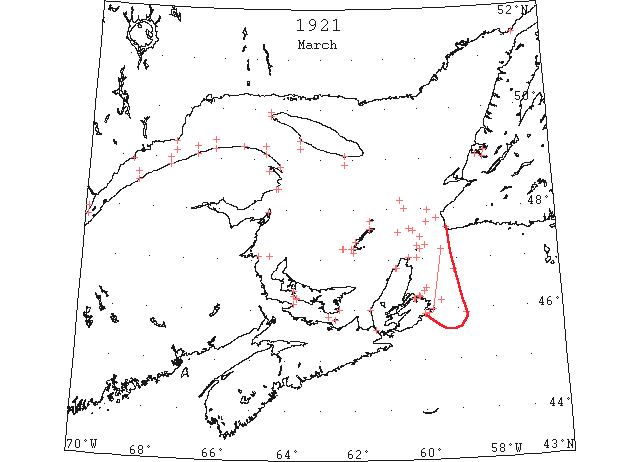
Mar 1 Crane Island: open ice. Cape Salmon: heavy open ice everywhere. Father Point: light open ice everywhere. Matane: heavy open ice everywhere, moving north. Cap Chat: heavy open ice distant. Rivière à la Martre: heavy close-packed ice inshore. Cape Magdalen: heavy open ice everywhere. Fame Point: heavy open ice everywhere. Cap des Rosiers: heavy close-packed ice everywhere, heavy open ice distant. Bersimis: heavy close-packed ice everywhere. Point des Monts: light close-packed ice distant. Southwest Point: heavy close-packed ice everywhere. Point Tupper: strait full of ice. Flat Point: heavy close-packed ice distant 10 miles, moving southeast. East Scatari: heavy close-packed ice inshore, moving northeast. (HB 1644 Mar 9 CSS)
Mar 2 Flat Point, heavy close packed ice distant moving SW. (HB #1645 Mar 16)
Mar 2 Father Point: light open ice distant. Matane: heavy open ice everywhere. Cap Chat: heavy open ice distant. Fame Point: light open ice everywhere. Cap des Rosiers: heavy close-packed ice everywhere, heavy open ice distant. Point des Monts: heavy close-packed ice distant. West Point: heavy close-packed ice everywhere. Southwest Point: heavy close-packed ice everywhere. South Point: heavy close-packed ice everywhere. Magdalen Islands: Grosse Isle, heavy open ice, moving easterly; Étang du Nord, heavy open ice stationary; West Point, heavy close-packed ice everywhere; Pleasant Bay, same condition. St. Paul Island: heavy open ice. Money Point: ice offshore. (HB 1645 Mar 16 CSS)
Mar 3 Flat Point, heavy close packed ice distant. Point Amour, close packed ice everywhere moving E. East Scatari, heavy open ice inshore moving N. (HB #1645 Mar 16)
Mar 3 Sydney, ice conditions in Cabot Strait are the worst in ten years according to news brought to Louisburg by ship masters who have succeeded in getting through the packs within the past few days. Newfoundland is reported to be entirely surrounded by impenetrable floes stretching from the Arctic circle to the Gulf, and dotted with monster bergs, some of them over two hundred feet high. This condition is expected to make the opening of navigation in Cape Breton ports much later than usual this spring. The collier “Hochelafa” which was yesterday morning stuck in heavy ice fifty miles off from Louisburg, has released herself and is now at Louisburg. (HH 04/03/1921 p1#6)
Mar 3 Cape Salmon: heavy open ice everywhere. Matane: heavy open ice everywhere, moving north. Fame Point: light open ice everywhere. Cap des Rosiers: heavy close-packed ice everywhere, heavy open ice distant. West Point: North Channel, heavy open ice inshore; South Channel, light close-packed ice everywhere. South Point: heavy close-packed ice everywhere. Cape Magdalen: heavy open ice everywhere. St. Paul Island: light open ice everywhere, moving north. Money Point: open ice distant. (HB 1645 Mar 16 CSS)
Mar 4 Crane Island: light ice. L’Islet: light close-packed ice distant. Cape Salmon: heavy close-packed ice distant. Father Point: packed ice everywhere. Cap Chat: heavy close-packed ice everywhere. Fame Point: light open ice everywhere. Cap des Rosiers: heavy close-packed ice inshore. West Point: light close-packed ice everywhere. Southwest Point: heavy close-packed ice everywhere. Cape Magdalen: heavy close-packed ice inshore. Money Point: heavy close-packed ice north and south. (HB 1645 Mar 16 CSS)
Mar 5 Flat Point, light open ice distant moving SW. East Scatari, heavy open ice inshore moving S. (HB #1645 Mar 16)
Mar 5 Crane Island: open ice. L’Islet: light some scattered ice fields. Cape Salmon: heavy close-packed ice everywhere. Father Point: packed ice everywhere. Matane: light open ice distant. Cap Chat: heavy close-packed ice everywhere. Fame Point: heavy open ice everywhere. Cap des Rosiers: heavy close-packed ice everywhere. West Point: heavy close-packed ice everywhere. Southwest Point: heavy open ice distant. South Point: light open ice distant. Cape Magdalen: heavy close-packed ice everywhere. Magdalen Islands: Grosse Isle, close-packed ice, going east; Étang du Nord, close-packed ice, stationary; West Point, heavy open ice everywhere; Pleasant Bay, still solid bridge of ice. St. Paul Island: heavy close-packed ice. Money Point: heavy close-packed ice everywhere, moving southeast. (HB 1645 Mar 16 CSS)
Mar 6 The furious gale which sprang up from the southwest and blew steadily all day Sunday had a great effect in driving the ice fields out of the Gulf and Cabot Strait. Reports from coast towns show that the floes were driven far out to sea by the storm. At New Waterford where floes were packed on the shore on Saturday there was yesterday open water as far as the eye could reach. At Glace Bay only scattered floes could be observed on the horizon. The Arctic ice packs in the Gulf and off Newfoundland are reported by incoming ship masters to be the worst in ten years (HH 09/03/1921 p13#5)
Mar 6 Yesterday at Louisburg a diver made an examination of the damaged “Turret Cape” which stove a hole in her bow through contact with ice floes off Louisburg on Sunday. The “Turret Cape” was on her way to St. John, NB, from Louisburg when she ran into the ice field when only a short distance from port. (HH 11/03/1921 p13 #2)
Mar 7 Cape Ray, heavy close packed ice everywhere moving SE. East Scatari, light open ice distant moving SW. (HB #1645 Mar 16)
Mar 7 Crane Island: open ice. Cape Salmon: heavy close-packed ice distant. Father Point: packed ice inshore. Matane: heavy close-packed ice everywhere. Cap Chat: heavy close-packed ice everywhere. Fame Point: heavy open ice everywhere. Cap des Rosiers: heavy close-packed ice inshore, heavy open ice distant. Point des Monts: close-packed ice everywhere. West Point: heavy close-packed ice everywhere. Southwest Point: heavy open ice distant. South Point: light open ice inshore. Cape Magdalen: heavy close-packed ice everywhere. Magdalen Islands: Grosse Isle, heavy open ice, moving east; Étang du Nord and West Point, heavy close-packed ice everywhere; Pleasant Bay, ice about 2 miles offshore. St. Paul Island: heavy close-packed ice, moving south. Money Point: heavy close-packed ice everywhere. (HB 1645 Mar 16 CSS)
Mar 8 Cape Ray, heavy open ice distant moving SE. Point Amour, heavy close packed ice stationary. East Scatari, light open ice distant (HB #1645 Mar 16)
Mar 8 Crane Island: open ice. Cape Salmon: heavy open ice everywhere. Father Point: heavy close-packed ice everywhere. Matane: heavy open ice everywhere. Cap Chat: heavy open ice. Fame Point: heavy open ice everywhere. Cap des Rosiers: heavy close-packed ice inshore, heavy open ice distant. Point des Monts: heavy close-packed ice distant. West Point: light open ice everywhere. South Point: light open ice inshore. Cape Magdalen: heavy open ice everywhere. Magdalen Islands: Grosse Isle, heavy close-packed ice, stationary; South Side of West Point, about 4 miles of heavy open ice. St. Paul Island: heavy close-packed ice everywhere, moving southeast. Money Point: heavy close-packed ice everywhere. (HB 1645 Mar 16 CSS)
Mar 9 The rains of last week followed by little frost has made it good skating on the Humber Arm. (TWS, p.Col. 2)
Mar 9 Heavy ice and fog in the Strait is hampering the car-ferry “Prince Edward Island.” One night she was help up at a point two miles off Borden and was unable to dock for several hours. (HH 09/03/1921 p13#4)
Mar 9 Matane: heavy open ice everywhere. Cap Chat: heavy open ice, stationary. Fame Point: heavy open ice everywhere. Cap des Rosiers: heavy close-packed ice inshore, distant. West Point: light close-packed ice everywhere. Southwest Point: light close-packed ice everywhere. Cape Magdalen: heavy open ice everywhere. St. Paul Island: heavy close-packed ice everywhere. Money Point: heavy close-packed ice everywhere. (HB 1645 Mar 16 CSS)
Mar 10 Cape Salmon: heavy open ice everywhere. Father Point: open ice inshore, moving east. Matane: heavy open ice inshore. Cap Chat: heavy open ice, stationary. Rivière à la Martre: heavy close-packed ice everywhere. Cape Magdalen: heavy close-packed ice everywhere. Fame Point: heavy open ice everywhere. Cap des Rosiers: heavy open ice everywhere. Bersimis: ice broken ½ mile from shore, no ice outside. West Point: heavy close-packed ice everywhere. Southwest Point: heavy close-packed ice everywhere. South Point: heavy close-packed ice everywhere. Magdalen Islands: West Point, about 2 miles of heavy open ice inshore, conditions unchanged elsewhere. St. Paul Island: heavy close-packed ice north, open south. Cape Ray: heavy close-packed ice, moving southeast. (HB 1646 Mar 23 CSS)
Mar 11 SS “Turret Cape” at Louisburg damaged by ice. (NYMR)
Mar 11 Father Point: light open ice inshore. Matane: heavy close-packed ice inshore. Cap Chat: heavy open ice everywhere Rivière à la Martre: heavy close-packed ice everywhere. Cape Magdalen: heavy close-packed ice everywhere. Fame Point: heavy open ice everywhere. Cap des Rosiers: heavy open ice everywhere. Cap d’Éspoir: ice moving out. West Point: North Channel, heavy close-packed ice everywhere; South Channel, heavy open ice inshore. Southwest Point: heavy open ice distant. South Point: light open ice inshore. Magdalen Islands: Grosse Isle, heavy close-packed ice, moving east; West Point, heavy close-packed ice everywhere; Pleasant Bay and Étang du Nord, conditions unchanged. St. Paul Island: heavy close-packed ice, moving southeast. Money Point: heavy close-packed ice, moving south. Cape Ray: freezing ice, making fast; heavy close-packed ice everywhere, moving southeast. Point Amour: heavy close-packed ice everywhere, moving east. (HB 1646 Mar 23 CSS)
Mar 12 Cape Salmon: heavy open ice everywhere. Father Point: open ice everywhere, moving with tides. Matane: heavy close-packed ice everywhere, moving north. Cap Chat: heavy open ice everywhere. Rivière à la Martre: heavy open ice distant. Cape Magdalen: heavy close-packed ice everywhere. Fame Point: heavy open ice everywhere. Cap des Rosiers: heavy open ice everywhere. West Point: North Channel, heavy close-packed ice everywhere; South Channel, heavy open ice inshore. Southwest Point: light open ice distant. South Point: heavy open ice inshore. Magdalen Islands: Étang du Nord and West Point, packed ice everywhere; Grosse Isle, close-packed ice, moving easterly; Pleasant Bay, about ½ mile of shore ice; steamer “Viking”, 25 miles southeast of Bird Rock, ice close-packed. St. Paul Island: heavy close-packed ice, moving east. Money Point: heavy close-packed ice north, open south. Cape Ray: heavy close-packed ice everywhere, stationary. Point Amour: heavy close-packed ice everywhere, moving east. Belle Isle: heavy close-packed ice everywhere. (HB 1646 Mar 23 CSS)
Mar 14 Signal Service reports concerning ice conditions in the St. Lawrence gives out the statement that from the port of Quebec east to Father Point the ice is light and open. From Father Point to Cabot Straits, there is heavy and close packed ice everywhere. From the port of Quebec west to Point du Lac the channel is open and practically free of ice, but from Point du Lac (near Three Rivers) west to the port of Montreal, the channel is frozen over. This ice, however, is not as thick as in previous years. (HH 14/03/1921 p11#5)
Mar 14 Matane: heavy open ice everywhere. Cap Chat: heavy open ice everywhere. Cape Magdalen: heavy close-packed ice everywhere. Fame Point: heavy open ice everywhere. Cap des Rosiers: heavy close-packed ice everywhere. West Point: North Channel, heavy close-packed ice everywhere; South Channel, light open ice inshore. Southwest Point: heavy close-packed ice inshore. South Point: light open ice distant. Magdalen Islands: Grosse Isle, packed ice, stationary; Étang du Nord, heavy close-packed ice everywhere; West Point, heavy open ice everywhere; Pleasant Bay, about 1 mile of shore ice; steamer “Viking”, 30 miles northeast of Bird Rock, close-packed ice. St. Paul Island: heavy open ice inshore, moving south. Money Point: heavy close-packed ice everywhere, moving south. Cape Ray: freezing ice, making fast. Point Amour: heavy close-packed ice everywhere, moving east. (HB 1646 Mar 23 CSS)
Mar 15 Crane Island: open ice. Father Point: light open ice distant. Matane: ice moving southeast. (HB 1646 Mar 23 CSS)
Mar 15 Cap Chat: heavy open ice everywhere. Rivière à la Martre: heavy open ice everywhere. Cape Magdalen: heavy open ice everywhere. Fame Point: heavy open ice everywhere. Cap des Rosiers: heavy close-packed ice everywhere, moving southeast. Cap d’Éspoir: sea covered with open ice. West Point: North Channel, light close-packed ice everywhere; South Channel, heavy open ice inshore. Southwest Point: light open ice distant. South Point: heavy open ice inshore. Magdalen Islands: West Point, ice about 12 miles from shore, ice conditions unchanged at other points; steamer “Viking”, 34 miles ESE of Bird Rock. St. Paul Island: heavy close-packed ice, moving south. Money Point: heavy open ice, moving south. Cape Ray: heavy close-packed ice everywhere, heavy close-packed ice, stationary. East Scatari: heavy close-packed ice distant. Point Amour: heavy close-packed ice everywhere, moving east. (HB 1646 Mar 23 CSS)
Mar 16 There was very good ice boating and skating on the Humber last week. The little snow that fell on Sun. spoiled it, and rain is now needed to put the ice in good trim again. (TWS, pg. 2, Col. 2)
Mar 16 There was good skating in the Bay the first part of the week. (TWS, pg. 2, Col. 3)
The Middle Arm is covered with a splendid sheet of very smooth ice, which extends out the Bay as far as one can see. (TWS, pg. 2, Col. 4)
Mar 16 The ice still blocks North Sydney and it is likely that the “Kyle” will have to continue her trips to Louisburg for some days yet (TWS, pg. 2, Col. 2)
Mar 16 Crane Island: light open ice everywhere. Matane: light southeast, heavy open ice inshore. Cap Chat: heavy close-packed ice distant. Rivière à la Martre: heavy open ice distant. Cape Magdalen: heavy open ice everywhere. Cap des Rosiers: heavy close-packed ice everywhere. Point des Monts: heavy close-packed ice everywhere, moving west. West Point: North Channel, heavy close-packed ice everywhere. Magdalen Islands: steamer “Viking” same position [34 miles ESE of Bird Rock], ice conditions unchanged. St. Paul Island: heavy close-packed ice, moving north. Money Point: heavy open ice, stationary. Cape Ray: heavy close-packed ice everywhere, moving northwest. East Scatari: heavy close-packed ice, moving southeast. (HB 1646 Mar 23 CSS)
Mar 17 Crane Island: [St. Lawrence] river covered with ice. Matane: light scattered ice. Cap Chat: heavy open ice everywhere. Rivière à la Martre: heavy open ice everywhere. Cape Magdalen: heavy open ice everywhere. Fame Point: heavy open ice everywhere. Cap des Rosiers: heavy close-packed ice everywhere. Cap d’Éspoir: ice all packed in cove. Bersimis: ice broken right inshore, moving east. Pointe des Monts: ice moving northeast. West Point: North Channel, heavy close-packed ice everywhere. Southwest Point: light open ice everywhere. South Point: heavy open ice inshore. Magdalen Islands: Grosse Isle: heavy distant ice, moving east. Étang du Nord: heavy open ice everywhere. Pleasant Bay: heavy scattered ice; steamer “Viking”, position about 28 miles east-northeast of Bird Rocks, ship jammed. St. Paul Island: heavy close-packed ice moving southeast. Money Point: heavy open ice inshore. Point Tupper: strait clear. Cape Ray: heavy open ice, moving southeast. Flat Point: heavy close-packed ice distant, moving southeast. East Scatari: heavy open ice distant. Point Amour: heavy close-packed ice everywhere. Belle Isle: heavy open ice distant, two bergs. (HB 1647 Mar 30 CSS)
Mar 18 Delayed by ice and fog the steamer “Pro Patria,” was late in arriving from St. Pierre on this trip, docking at the Plant wharf Wednesday night. They intended leaving the “Pro Patria’ at Louisburg but on account of weather and ice conditions the steamer did not call at the Cape Breton port. (HH 18/03/1921 p13#1)
Mar 18 Crane Island: [St. Lawrence] river covered with ice. L’Islet: [St. Lawrence] river covered with ice. Father Point: light packed ice everywhere. Matane: light open ice distant. Cap Chat: heavy close-packed ice everywhere. Rivière à la Martre: heavy open ice everywhere. Cape Magdalen: heavy close-packed ice inshore. Fame Point: heavy open ice moving east. Cap des Rosiers: heavy close-packed ice everywhere. Cap d’Éspoir: ice all packed in cove. West Point: North Channel, heavy close-packed ice everywhere; South Channel, heavy open ice. Southwest Point: light open ice everywhere. South Point: light close-packed ice everywhere. Magdalen Islands: Grosse Isle: heavy ice distant. Étang du Nord: heavy close-packed ice. West Point: heavy open ice. Pleasant Bay: about 1 mile shore ice, rest clear; steamer “Viking” 40 miles east-southeast[sic] of Bird Rocks, still jammed. Money Point: heavy open ice, moving southeast. Point Tupper: strait clear. Flat Point: heavy close-packed ice, moving southeast. East Scatari: heavy open ice everywhere. Point Amour: heavy close-packed ice everywhere, moving east. (HB 1647 Mar 30 CSS)
Mar 19 Crane Island: scattered ice. L’Islet: scattered ice. Father Point: packed ice everywhere. Matane: heavy close-packed ice everywhere. Cap Chat: heavy close-packed ice everywhere. Rivière à la Martre: heavy close-packed ice everywhere. Cape Magdalen: heavy close-packed ice everywhere. Fame Point: heavy open ice everywhere. Cap des Rosiers: heavy close-packed ice everywhere, moving southeast. West Point: North Channel, 1 mile with heavy broken ice alongshore. South Point: heavy open ice inshore. Magdalen Islands: Grosse Isle: heavy close-packed ice. Étang du Nord: heavy close-packed ice. West Point: heavy close-packed ice. Money Point: heavy close-packed ice, moving southeast. Point Tupper: strait clear. Cape Ray: steamer “Viking” 30 miles northwest; heavy open ice distant, moving south. Flat Point: heavy close-packed ice everywhere, moving southeast. (HB 1647 Mar 30 CSS)
Mar 21 Crane Island: heavy open ice moving north. L’Islet: light scattered ice moving down. Father Point: light open ice everywhere. Matane: heavy open ice everywhere. Cap Chat: heavy open ice distant. Rivière à la Martre: heavy open ice distant. Cape Magdalen: heavy open ice everywhere. Fame Point: heavy open ice inshore. Cap des Rosiers: heavy close-packed ice inshore. Bersimis: heavy close-packed ice everywhere. West Point: heavy open ice inshore. Southwest Point: light open ice everywhere. Magdalen Islands: Grosse Isle: heavy open ice, moving west. West Point: close-packed ice everywhere. Pleasant Bay: loose drift ice; steamer “Viking” 30 miles north-northeast of St. Paul Island. Money Point: heavy open ice, moving north. Point Tupper: strait clear. Flat Point: heavy open ice everywhere, moving east. East Scatari: heavy open ice everywhere, moving east. (HB 1647 Mar 30 CSS)
Mar 22 Cape Ray: Heavy close packed ice, distant, moving south; E.Scatari: everywhere. (NYMR)
Mar 22 Crane Island: open ice everywhere. L’Islet: [St. Lawrence] river covered with ice. Father Point: light open ice inshore. Matane: heavy open ice everywhere. Cap Chat: heavy close-packed ice everywhere. Rivière à la Martre: close-packed ice everywhere. Cape Magdalen: heavy close-packed ice everywhere. Fame Point: heavy open ice everywhere, moving east. Cap des Rosiers: heavy open ice everywhere, moving southeast. Bersimis: heavy close-packed ice everywhere. West Point: South Channel, very light ice everywhere. South Point: heavy open ice inshore. Magdalen Islands: Grosse Isle: heavy open ice, moving west. West Point: heavy ice distant. Pleasant Bay: about 1 mile of shore ice; steamer “Viking” 10 miles north-northeast of St. Paul [Island]. Money Point: close-packed ice everywhere, heavy close-packed ice, stationary. Point Tupper: strait clear. Cape Ray: heavy close-packed ice distant, moving south. Flat Point: heavy close-packed ice everywhere, moving south. East Scatari: heavy open ice everywhere, moving south. (HB 1647 Mar 30 CSS)
Mar 23 L’Islet: [St. Lawrence] river covered with ice. Matane: heavy open ice distant. Cap Chat: heavy close-packed ice everywhere. Rivière à la Martre: heavy close-packed ice everywhere. Cape Magdalen: heavy close-packed ice everywhere. Fame Point: heavy open ice everywhere. Bersimis: heavy close-packed ice everywhere. South Point: light open ice everywhere. Magdalen Islands: Grosse Isle: heavy close-packed ice everywhere. Étang du Nord: heavy close-packed ice everywhere. West Point: heavy close-packed ice everywhere. Point Tupper: strait clear. Cape Ray: heavy close-packed ice distant, moving south. Flat Point: heavy close-packed ice everywhere, moving southeast. East Scatari: heavy open ice everywhere, moving southeast. Point Amour: heavy close-packed ice, moving east. Belle Isle: heavy close-packed ice everywhere. (HB 1647 Mar 30 CSS)
Mar 24 L’Islet: open ice. Cape Salmon: heavy open ice distant. Father Point: light open ice inshore. Matane: heavy open ice everywhere, moving north. Cap Chat: heavy open ice distant. Rivière à la Martre: heavy close-packed ice everywhere. Cape Magdalen: heavy close-packed ice everywhere. Fame Point: heavy open ice everywhere, moving east. Cap des Rosiers: heavy open ice everywhere, moving northeast. Cap d’Éspoir: clear of ice 3 miles from shore. Southwest Point: very light ice everywhere with open water. Magdalen Islands: Grosse Isle and Étang du Nord, heavy open ice, moving east; West Point, heavy loose-packed ice everywhere; SS “Viking” 5 miles southeast of St. Paul [Island]. Money Point: heavy close-packed ice everywhere. Point Tupper: loose ice. Cape Ray: heavy open ice everywhere. Flat Point: heavy close-packed ice distant, moving southeast. East Scatari: heavy close-packed ice everywhere, moving east. Point Amour: heavy close-packed ice everywhere, moving east. (HB 1648 Apr 6 CSS)
Mar 25 Ice conditions in the Gulf and off the mouth of Sydney Harbor are reported to be very much worse that than any time before this season. The northeast wind which had prevailed for the past two days is jamming the heavy ice floes down heavily on the north shore of Cape Breton and the harbor, so as to be impregnable. The prevailing wind is also making matters much worse for the sealing steamers in the north. The ice is forcing them closer to land each hour, and lessens their chance of ever reaching the seals herds. The steamers when last heard of were reported to be lying too [sic], waiting for ice conditions to better. (HH 25/03/1921 p11#1)
Mar 25 Cape Salmon: heavy open ice distant. Magdalen Islands: Grosse Isle and Étang du Nord, ice conditions same as yesterday; steamer “Viking” 10 miles east of St. Paul [Island]. Money Point: heavy open ice, stationary. Point Tupper: scattered ice. Cape Ray: heavy close-packed ice distant, moving southeast. Summerside, P.E.I.: channel opening inside, harbour breaking up outside. Cape Bear, P.E.I.: strait full of scattered ice. Point Escuminac, N.B.: heavy close-packed ice distant. Port Hood, N.S.: bay full of ice. (HB 1648 Apr 6 CSS)
Mar 26 Cape Salmon: light open ice everywhere. Cap Chat: heavy open ice distant. Cap d’Éspoir: clear of ice 3 miles from shore. Southwest Point: light open ice everywhere. Magdalen Islands: Étang du Nord, light open ice; West Point, heavy close-packed ice everywhere; Grosse Isle, heavy ice distant, moving east; Pleasant Bay, scattered ice. Money Point: heavy close-packed ice, moving southeast. Flat Point: heavy close-packed ice distant for 10 miles, moving southeast. Summerside, P.E.I.: harbour ice going out fast. Cape Bear, P.E.I.: strait full of loose ice. (HB 1648 Apr 6 CSS)
Mar 28 North Sydney, the Newfoundland steamer “Kyle” arrived here at 5:30 this afternoon, her first trip to this port since January. She left Port-aux-Basque at five o’clock yesterday afternoon and was delayed by having to go through a considerable field of ice in Cabot Strait, as well as encountering fog. There is only a little scattered ice off this port and once through the ice in the strait the “Kyle” had no difficulty in making North Sydney. In fact, as far as concerns ice conditions at this port and in its immediate vicinity, she might have come here regularly during at least the past month. (HH 29/03/1921 p11#2)
Mar 28 Cap Chat: open ice distant. Cap des Rosiers: heavy close-packed ice inshore. Southwest Point: light close-packed ice everywhere. Flat Point: heavy close-packed ice distant. Summerside, P.E.I.: ice going fast. Cape Bear, P.E.I.: open ice. Cape Tormentine, N.B.: light close-packed ice everywhere. Port Hood, N.S.: bay full of stationary ice. Borden, P.E.I.: not much ice. (HB 1648 Apr 6 CSS)
Mar 29 Cap Chat: heavy open ice distant. South Point: light open ice inshore. Summerside, P.E.I.: ice breaking up. Port Hood, N.S.: scattered ice. Borden, P.E.I.: ice breaking up fast. (HB 1648 Apr 6 CSS)
Mar 29 From Feb 14, 1922 report on ‘Ice Conditions, Montréal, Canada’.-The following was received from the American consul general, Montréal: “… In 1921 the port was opened on March 29, an especially early date”. (HB 1696 Mar 8, 1922)
Mar 30 L’Islet: [St. Lawrence] river partly covered with scattered ice. Cap Chat: heavy open ice distant. Rivière à la Martre: heavy close-packed ice everywhere. Fame Point: light open ice inshore. South Point: heavy open ice inshore. Magdalen Islands: Grosse Isle and Étang du Nord, heavy close-packed ice everywhere. Point Tupper: strait full of drift ice. Flat Point: heavy close-packed ice inshore, moving southeast. Summerside, P.E.I.: harbour open. Cape Tormentine, N.B.: light close-packed ice distant. Port Hood, N.S.: ice breaking up and moving. Borden, P.E.I.: not much ice in strait to-day. (HB 1648 Apr 6 CSS)
Mar 30 [April 1 report] Louisburg, N.S.: SS “Kyle” left Port aux Basques, Newfoundland; Mar 30, steered south 55° west magnetic for 25 miles, met heavy drift and northerly gale, hauled south for Louisburg, and encountered heavy ice with large lake of water up to Scattorio[sic = Scatari?] Island. No ice westward off there. (HB 1649 Apr 13 CSS)
Mar 31 Fame Point: light open ice distant. Cap des Rosiers: light open ice everywhere. Point Escuminac: heavy open ice inshore. West Point: heavy open ice everywhere. Southwest Point: light open ice everywhere. South Point: heavy open ice inshore. Magdalen Islands: about same ice conditions, steamer “Viking” 10 miles east [of] St. Paul Island. Money Point: heavy close-packed ice moving southeast. Point Tupper: loose ice. Cape Ray: heavy close-packed ice distant, heavy open ice stationary. Flat Point: heavy open ice distant. East Scatari: heavy open ice everywhere moving southeast. Point Amour: heavy close-packed ice everywhere. Cape Tormentine: light open ice distant. Cape Bear: scattered ice few miles west. Summerside, P.E.I.: floating ice in harbour. Port Hood: not much ice in sight to-day. Borden, P.E.I.: strait full of ice. (HB 1649 Apr 13 CSS)
Apr 1 J.A. Ward, Lightkeeper, Miscou Point, New Brunswick: Opening date. (CIS IC0756_2)
Apr 1 Point Escuminac: heavy close-packed ice. Southwest Point: light open ice everywhere. Summerside, P.E.I.: floating ice in harbour. Port Hood: ice moving off. Borden, P.E.I.: harbour full yet. (HB 1649 Apr 13 CSS)
Apr 2 Ice has been reported as follows: 44°45’N 57°15’W to 44°58’N 56°29’W, field ice. (HB 1649 Apr 13)
Apr 2 Point Escuminac: heavy open ice inshore. West Point: North Channel, 1 mile wide, light broken ice along shore. Southwest Point: light open ice everywhere. South Point: light open ice everywhere. Money Point: heavy close-packed ice stationary. Point Amour: heavy close-packed ice everywhere moving southeast. Belle Isle: heavy open ice everywhere. Heath Point: open ice distant. Summerside, P.E.I.: floating ice in harbour. Port Hood: some drift ice along shore. West Point: light open ice along shore. (HB 1649 Apr 13 CSS)
Apr 4 Southwest Point: light open ice everywhere. South Point: light close-packed ice distant. Magdalen Islands: Grosse Isle, open ice moving. Étang du Nord and Northwest Point, close-packed ice. South Side West Point, open ice distant, and Pleasant Bay, all clear. Money Point: heavy close-packed ice moving southeast. Point Tupper: strait full of ice. Flat Point: heavy open ice distant moving south. East Scatari: light open ice distant moving south. Point Amour: heavy close-packed ice stationary. Belle Isle: ice moving southeast. Cape Tormentine: light close-packed ice distant. Port Hood: some drift ice along coast, clear outside. Borden, P.E.I.: considerable ice on this shore. (HB 1649 Apr 13 CSS)
Apr 5 Southwest Point: light open ice everywhere. Money Point: heavy close-packed ice moving southeast. Flat Point: heavy close-packed ice distant moving southeast. East Scatari: heavy close-packed ice moving southeast. Borden, P.E.I.: ice packed inshore. Cape Magdalen: light open ice distant. (HB 1650 Apr 20 CSS)
Apr 6 The ice in the Humber is cutting down very rapidly and were we to have a couple more weeks of weather such as last week we would soon have open navigation. (TWS, pg. 2, Col. 2)
Apr 6 Montreal , “Cassandra” may be first up the St. Lawrence, in spite of the early opening of navigation – without precedent since 1850 – none of the shipping companies seem disposed to take advantage of the fact, and send their ships up the river much, if any, earlier that is usual. The reason generally stated is the possibility of ice in the gulf making navigation there dangerous for some time yet, but the present small amount of freight offering is undoubtedly a prime factor. The port of Montreal was open this year on March 29th, but will nevertheless experience little shipping activity before the first of May, after which date there will be plenty of vessels moving. (HH 08/04/1921 p13#6)
Apr 6 Fame Point: light open ice inshore. Magdalen Islands: Grosse Isle: close-packed ice everywhere, stationary; Pleasant Bay, north side of West Point, about 12 miles close-packed ice; Étang du Nord, open ice everywhere. Money Point: heavy close-packed ice everywhere. Flat Point: heavy close-packed ice distant, moving southeast. Point Amour: heavy close-packed ice distant, moving east. Cape Ray: heavy close-packed ice distant, moving southeast. Port Hood, N.S.: scattered ice inshore. Cape Tormentine, N.B.: light close-packed ice inshore. Borden, P.E.I.: considerable light-packed ice. (HB 1650 Apr 20 CSS)
Apr ~7 North Sydney, N.S. [April 8 report]: steamer “Kyle” left Port aux Basques, Newfoundland, Apr. 5, at midnight, steered south 55° west in open water for 9 miles, then small pan ice until abeam of Cape North, then large unbroken sheet ice to within 2 miles of Flat Point. (HB 1650 Apr 20 CSS)
Apr 7-13 Ice Reported by Steamers. from [or via] CGS “Kyle”: Left North Sydney Apr 7 for St. John’s, Newfoundland. Encountered heavy close-packed ice off Flat Point. Worked down through very heavy sheet ice to Scatari Island; took departure from there and worked out through 75 miles of heavy ice ESE (mag); from there to open water. Returning from St. John’s via Port aux Basques, met heavy pan ice 15 miles S 55° W of there, and held same until reached land on Cape Breton side. Sydney Harbour half full of ice. (HB 1651 Apr 27 CSS)
Apr 8 Money Point: heavy open ice. Flat Point: heavy close-packed ice everywhere. Point Maquereau: open ice everywhere, moving east. East Scatari: heavy close-packed ice everywhere. Cape Ray: heavy open ice distant, moving north. Port Hood, N.S.: scattered ice inshore. Cape Tormentine, N.B.: light open ice everywhere. Borden, P.E.I.: heavy loose ice in strait. (HB 1650 Apr 20 CSS)
Apr 9 Money Point: heavy open ice moving southeast. Flat Point: heavy close-packed ice distant, moving southeast. Rivière à la Martre: light open ice inshore. East Scatari: heavy open ice inshore. Cape Ray: steamer “Viking” about 15 miles west this a.m., in heavy sheet ice. Borden, P.E.I.: heavy loose ice in strait. (HB 1650 Apr 20 CSS)
Apr 10 North Sydney, exceedingly heavy ice prevails between here and the steamer “Kyle,” which left here for St. John’s at 5 a.m. is still in sight of land and may be obliged to return to port. W F Coaker, Minister of Marine and Fisheries; Sir John Crosbie, member of the Newfoundland house of assembly, and several other prominent Newfoundland people are on board and it is presumed that on their account the steamer was ordered to Newfoundland. (HH 11/04/1921 p11#3)
Apr 11 Cape Magdalen: light open ice distant. Magdalen Islands: Pleasant Bay, side of West Point, about 5 miles scattered ice; Grosse Isle and Étang du Nord, scattered ice everywhere. Flat Point: heavy open ice moving south. Point Maquereau: light open ice distant. Cape Tormentine, N.B.: light close-packed ice distant. (HB 1650 Apr 20 CSS)
Apr 12 The first vessel to arrive in Charlottetown this spring was the “Lady May” which came from Belle River on Tuesday, 12th. (Pat 14 Apr p8 c3)
Apr 12 The harbour opened on April 12th, in 1921 (Pat 21 Apr 1923 p6 c4)
Apr 12 Cape Magdalen: some ice distant. Flat Point: heavy open ice everywhere. Point Maquereau: light open ice everywhere. Cape Tormentine, N.B.: light close-packed ice inshore. Borden, P.E.I.: not much ice this side. (HB 1650 Apr 20 CSS)
Apr 13 Coming in from Penguin Arm at the end of last week it was reported that there was no sign of the ice breaking up at that point of the Bay. Around Middle Arm Point there was not a rent in the ice. (TWS, pg. 2, Col. 1)
Apr 13 The SS “Kyle” was stuck in the ice a couple of days last week off North Sydney. She got clear and proceeded to St. John’s. (TWS, pg. 3, Col. 7)
Apr 13 Cape Magdalen: open ice distant, moving east. Fame Point: little broken-up ice offshore. Magdalen Islands: Grosse Isle, 7 miles broken ice inshore, stationary; Étang du Nord and Northwest Point, about 1 mile of light scattered ice. No change elsewhere. Money Point: open ice everywhere, moving east. Flat Point: heavy open ice everywhere. Point Maquereau: light open ice distant, moving east. Cap des Rosiers: light open ice distant. Cape Tormentine, N.B.: light close-packed ice inshore. (HB 1650 Apr 20 CSS)
Apr 14 45°40’N 59°08’W heavy drift ice with small growlers. (HB #1655 May 25)
Apr 14 Magdalen Islands: Grosse Isle, about 7 miles open ice, moving east; Étang du Nord, scattered ice from west to north everywhere. Money Point: heavy close-packed ice everywhere. Flat Point: heavy open ice everywhere, moving southeast. Cape Tormentine: light open ice inshore. Borden: some scattered ice. (HB 1651 Apr 27 CSS)
Apr 15 47°10’N 58°30’W heavy field ice with small growlers moving SE. (HB #1655 May 25)
Apr 15 45°36’N 60°W field ice in a 10 mile radius. (HB #1654 May 18)
Apr 15 Magdalen Islands: Grosse Isle, scattered ice about 8 miles. West Point, about 6 miles scattered ice; Étang du Nord, scattered ice about 5 miles. Point Maquereau: light open ice distant. Money Point: heavy close-packed ice, stationary. Cape Tormentine: light close-packed ice distant. CGS “Stanley”: position this a.m., 5 miles NE Scatari Island, N.S. Heavy open ice everywhere. (HB 1651 Apr 27 CSS)
Apr 16 47°33’N 60°05’W heavy field ice moving northerly. (HB #1655 May 25)
Apr 16 The first schooner of the season arrived in Summerside on 16th. She came from Buctouche and her captain reports little ice in the Strait. (Pat 21 Apr p8 c3)
Apr 16 Georgetown – Schooner “Ryse” arrived from Pictou on 16th bound for Magdalene Islands. The captain has already made one trip down the Nova Scotia shore. He holds the record for the latest crossing of the Gulf in a schooner for the last 30 years having crossed from Guysborough to Georgetown about 20 years ago in schooner “Marcella Butler” on 22nd January. (Pat 22 Apr p2 c4)
Apr 16 Ice Reported By Steamers. from [or via] CGS “Kyle”: Left Port aux Basques and steered south 55°W. Met small open ice to 14 miles off, then heavy open and scattered ice to within 1 mile of Flat Point. (HB 1651 Apr 27 CSS)
Apr 16 CGS “Stanley”: at 8 a.m. [Saturday, April 16], 20 miles east of Eastpoint, Magdalen Islands; light SW wind. Clear from Cape North on a line from Bird Rocks by west. Heavy open and thin scattered ice to Magdalen Islands. At 4 p.m. [Saturday, April 16], 4 miles SE Entry Island; wind light, SW; overcast. Loose field ice everywhere, some ridges of heavy ice; lot of open water between ice fields between Magdalen Islands and Cape Breton coast. At 8 p.m. [Saturday, April 16] anchored at Amherst Island. From 4 miles SE Entry Island to Entry Island, passed through loose field ice. Strong west wind; foggy. (HB 1651 Apr 27 CSS)
Apr 16 SS “W.H. Tilford”: passed through 30 miles of heavy field ice in a line 48°30’N 59°55’W, 48°30’N 60°50’W; thence clear water to a point 10 miles south to off Bird Rocks. Steamed NNE (mag) through heavy field ice to a point SE 1/4 E 5 miles from Bird Rocks; thence 18 miles through heavy packed ice to clear water in 48°N 61°20’W. No ice to-day. (HB 1651 Apr 27)
Apr 17 Heavy field ice N and NW of Bird Rock. (HB #1655 May 25)
Apr 17 CGS “Stanley”: at 9 p.m. [Saturday, April 16], approximately 21 miles NW (mag) off Cape Ray. Was stalled in field ice 15 miles north by west off Cape Anguille; ice all the way to Cape George. Trying to find an opening towards St. Paul Island. At noon, 47°34’N 60°03’W. At 4 a.m. Sunday morning [April 17], at anchor Amherst Island; strong gale SE. At 8 a.m. have moved to new anchorage off Point Basse. Strong gale NE; sleeting, cloudy, and raining. Sunday at noon anchored off Port Basse. Distant ice to east of us moving south. At 4 p.m. [Sunday], 5 miles ESE of Entry Island; wind strong, east; light patches of open ice, mostly clear water. At 8 p.m. Sunday, 10 miles ESE end Magdalen Islands; heavy open ice. Thirteen miles east of Entry Island passed through 5 miles of heavy open ice. Thirteen miles SE of East Point, Magdalen Islands, very heavy ice with large herds of seals. Have steamed for 15 miles in heavy open ice. Clear; wind light, NE. (HB 1651 Apr 27 CSS)
Apr 17 CGS “Stanley”: [Sunday, p.m.] stopped in heavy close-packed ice 8 miles south of Bird Rocks, waiting for daylight. From 10 miles ESE from East Point, Magdalen Islands, passed through heavy close-packed ice. (HB 1651 Apr 27 CSS)
Apr 18? The Canadian government icebreaker “Stanley” has reported for ice duty in Cabot Straits and is ready to supply incoming ships with information regarding ice conditions in the Gulf.(Pat 18 Apr p4 c6)
Apr 18 The steamer “Harland” left yesterday on her first trip of the season going to China Point. (Pat 19 Apr p8 c3)
Apr 18 Money Point: heavy open ice north, heavy close-packed ice south and east. Flat Point: heavy open ice everywhere, moving to the south. Point Amour: heavy open ice everywhere. Belle Isle: heavy open ice distant. (HB 1651 Apr 27 CSS)
Apr 18 Ice Reported By Steamers. from [or via] CGS “Kyle”: Left Port aux Basques and steered south 55°W. Met small open ice to 14 miles off, then heavy open and scattered ice to within 1 mile of Flat Point. (HB 1651 Apr 27 CSS)
Apr 18 CGS “Stanley”: at 4 a.m. [Monday, April 18], in same position; clear; wind light, NW. At 8 a.m., 10 miles north (mag) from Bird Rocks, no ice in sight from Bird Rocks. Passed through from 25 to 30 miles heavy open ice everywhere; clear; wind light, NW. At noon, in 48°46’N 61°33’W; wind light, north. No ice between here and Bird Rocks. Ice seems to be south of Magdalen Islands and Bird Rocks. (HB 1651 Apr 27 CSS)
Apr 18 CGS “Stanley”: at 4 p.m. [Monday, April 18], in 48°50’N 61°10’W. At 1.35 p.m. was 2½ miles from Heath Point Light. Now steaming towards Cape Ray. No ice in sight between Bird Rocks and Heath Point. At 8 p.m., in 48°20’N 60°22’W; in heavy open ice extending in all directions as far as can be seen. Steamed 70 miles SSE (mag) before meeting ice. At 9 p.m. [Monday] steamed into heavy ice, 48°15’N 60°15’W. Stopped until daylight. (HB 1651 Apr 27 CSS)
Apr 18 SS “Manola”: from Louisburg, N.S., through Canso Gut and Northumberland Straits up to West Point of Prince Edward Island to Cape Gaspé, around Gaspé Coast to Father Point, sighted no ice. Sixty miles ESE of Scatarie on Mosaine[sic = Misane] Bank also Banquereau Bank, heavy ice field, the limit of the ice 10 or 15 miles west of St. Pierre Banks. This ice is heavy but with much open water. The ice is beginning to disappear. (HB 1651 Apr 27)
Apr 19 First arrival of season at Quebec. (WBB)
Apr 19 Magdalen Islands: Grosse Isle, 2 miles loose ice, stationary; West Point, about 4 miles loose ice; Étang du Nord, 1 mile loose ice. Money Point: heavy open ice everywhere. Flat Point: heavy open ice everywhere, stationary. Cape Tormentine: not much ice in sight. Cape Bear: not much ice in sight. (HB 1651 Apr 27 CSS)
Apr 19 CGS “Stanley”: at 4 a.m. [Tuesday, April 19] stopped in heavy ice waiting for daylight. At 8 a.m., 8 miles north of Cape Ray; no ice in sight on a line from Heath Point to Cape Anguille. Steamed 70 miles from Heath Point in clear water; then 15 miles of heavy and light ice; then clear water to Cape Anguille to the eastbound. Could see ice moving out from Bay St. George, Newfoundland. At noon [Tuesday], St. Paul Island bearing west 8 miles, light field ice, very open. From Cape Ray west 28 miles met no ice. (HB 1651 Apr 27 CSS)
Apr 19 CGS “Stanley”: at 4 p.m. [Tuesday, April 19], in 47°25’N 60°32’W, in heavy ice. There is a field of ice extending from Magdalen Islands east to Cape Anguille, and from 15 to 20 miles wide. Ships should keep to Cape Ray entering Gulf [of St. Lawrence], as that is the clearer water. (HB 1651 Apr 27 CSS)
Apr 19 CGS “Stanley”: at midnight [Tuesday], 35 miles NNE of St. Paul [Island]; heavy ice. Wind strong, ES; overcast, with snow squalls. (HB 1651 Apr 27 CSS)
Apr 19 SS “Venusia”: approaching Begot Point, steered from Cape Ray to pass 10 miles off Bird Rocks. Entered into large field ice 20 miles from Cape Ray; passed into open water after steaming 15 miles through loose ice. (HB 1651 Apr 27)
Apr 20 The ice in Humber Arm broke on Mon. Considerable ice still blocks the Bay. It moved off on Mon., but yesterday’s in wind brought it to the shore again. (TWS, pg. 2, Col. 2)
Apr 20 North Sydney, steamer “Huntaago” arrived Sunday morning from Bergen; had a good trip over till nearing Flint Island she was caught in the ice. The steamer “Stanley” went to her assistance and cut her out and pulled her clear. It was a stiff and four hausers parted getting her out. The Norwegians were amazed at the facility with which the ice breaker cleared a path to Sydney for them. Gulf of St. Lawrence, north of Bird Rocks, is clear of ice. (HH 26/04/1921 p11#6 )
Apr 20 Magdalen Islands: Grosse Isle, about 3 miles loose ice, moving east; Étang du Nord, about 2 miles loose ice. (HB 1651 Apr 27 CSS)
Apr 20 Money Point: ice offshore. Flat Point: heavy open ice. Steamer 10 miles east working through ice. Cape Ray: heavy open ice everywhere, moving southeast. (HB 1651 Apr 27 CSS)
Apr 20 CGS “Stanley”: ten miles north of Cape North. Wind light, north; misting, heavy open ice everywhere. At noon, 3 miles south of St. Paul [Island], Cape Breton, pass all clear water. (HB 1651 Apr 27 CSS)
Apr 20 CGS “Stanley”: [evening of Wednesday, April 20] stopped in heavy open ice everywhere till daylight, 25 miles north by east off Cape North; east wind and misty. (HB 1651 Apr 27 CSS)
Apr 20 CGS “Stanley”: in ice … 12 miles east [of Flat Point from an April 21 report]. (HB 1652 May 4 CSS)
Apr 21 Money Point: very little ice to be seen north, heavy close-packed ice south and east. Flat Point: heavy open ice everywhere. Point Amour: heavy close-packed ice everywhere, moving southeast. (HB 1652 May 4 CSS)
Apr 22 Money Point: little ice to the south. Flat Point: heavy open ice distant, moving southeast; CGS “Stanley” in ice since yesterday, 12 miles east. Point Amour: heavy close-packed ice everywhere, moving to the west. Belle Isle: ice moving south. (HB 1652 May 4 CSS)
Apr 22 North Sydney, the Quebec schooner “Maria Lydia” deserted and adrift in the gulf ice fields, was picked up about 20 miles from Bird Rock on Saturday last by the Canadian Government ice breaker “Stanley”. It is supposed she was anchored in the river St. Lawrence and when the ice broke up her chains parted and drifted down with the current. (HH 23/04/1921 p1#3,4)
Apr 23 Money Point: some ice north and east. [Saguenay River:] Anse St. Jean: ice in bay still holding; not expected to clear before early next week. Flat Point: heavy open ice. (HB 1652 May 4 CSS)
Apr 25 Flat Point: scattered and heavy open ice distant. (HB 1652 May 4 CSS)
Apr 25 CGS “Stanley”: Point Aconi to Cape Smokey, loose open ice. (HB 1652 May 4 CSS)
Apr 26 SS “Waalhaven” at Halifax with propeller damage having been caught in ice fields off Cape Breton. (NYMR)
Apr 26 Heavy field ice for 34 miles S 34 E from Cape North. (HB #1655 May 25)
Apr 26 SS “W.H. Tilford” 10 miles south (mag) from Cape North, passing through field ice and small growlers. (HB 1652 May 4)
Apr 26 SS “Canadian Trader”: encountered heavy ice in 47°16’N 58°46’W. (HB 1652 May 4)
Apr 26 SS “Kiaora”: close-packed and very small ice in 46°42’N 38°22’W[sic = 58°22’W]. (HB 1652 May 4)
Apr 27 Bergs: 46°43’N 58°32’W. (NYMR)
Apr 27 Point Amour: heavy close-packed ice everywhere, moving southeast. Belle Isle: light close-packed ice distant. (HB 1652 May 4 CSS)
Apr 28 Point Amour, heavy close packed ice everywhere moving. (HB #1653 May 11)
Apr 29 Flat Point, scattered broken ice distant. (HB #1653 May 11)
Apr 30 Reports coming to hand show that the ice situation in the lower part of the Gulf is much better than in normal years. The “Minnedosa” has already clipped a day off her sailing schedule and every indication points to her making a record run through the gulf and up the St. Lawrence. (HH 30/04/1921 p15#4)
May 4 Navigation will be open shortly. (TWS, pg. 1, Col. 7)
May 4 Capt. Joseph Petipas, who arrived in Bay St. George, said that he sighted ice off Port au Port Bay and at one time he feared his vessel would be caught but a change of wind took the floe off shore, and he thought there would be no further ice trouble along that part of the coast this season. (TWS, pg. 2, Col. 3)
May 4 Point Amour, heavy open ice everywhere moving SE. (HB #1653 May 11)
May 11 The mailman from Bonne Bay on Mon saw no ice coming up. (TWS, pg. 2, Col. 2)
May 13 Point Amour, heavy open ice everywhere. (HB #1655 May 25)
May 21 Point Amour, heavy close packed ice inshore. (HB # 1656 Jun 1)
Jun 1 44°02‘N 56°08’W a piece of ice about 45 feet long and 20 feet wide. (HB #1666 Aug 10)
Jun 7 Point Amour, no ice in sight. (HB #1659 Jun 22)
Jun 16 First Westbound steamer through the strait of Belle Isle. (WBB)