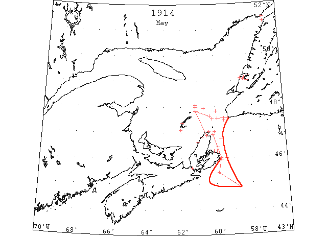
1914 Season
Nov 10 Last eastbound steamer through the Strait of Belle Isle. (WBB)
Nov 30 Last departure of the season from Quebec. (WBB)
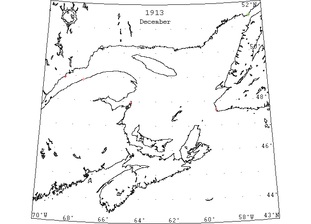
Dec 10 Belle Isle: a berg. (HB 1269 Dec 24 CSS)
Dec 11 Belle Isle: a berg. (HB 1269 Dec 24 CSS)
Dec 12 Belle Isle: a berg. (HB 1269 Dec 24 CSS)
Dec 13 Belle Isle: two bergs. (HB 1269 Dec 24 CSS)
Dec 16 Belle Isle: two bergs. Cape Ray: ice making fast. L’Islet: light sheet ice. (HB 1269 Dec 24 CSS)
Dec 17 J.A. Ward, Lightkeeper, Miscou Point, New Brunswick: Closing date. (CIS IC0756)
Dec 17 Belle Isle: two bergs. Point Amour: two bergs. (HB 1269 Dec 24 CSS)
Dec 18 Belle Isle: slob ice and two bergs. Point Amour: a berg. (HB 1270 Dec 31 CSS)
Dec 20 Belle Isle: two bergs. Crane Island: light scattered ice. Matane: ice making [fast] inshore. (HB 1270 Dec 31 CSS)
Dec 21 Belle Isle: four bergs. (HB 1271 Jan 7 1914 CSS)
Dec 22 Belle Isle: three bergs. Point Amour: a berg. (HB 1270 Dec 31 CSS)
Dec 23 Belle Isle: scattered sheets of slob ice and a berg. Point Amour: three bergs. (HB 1270 Dec 31 CSS)
Dec 23 Crane Island: light close packed ice. (HB 1270 Dec 31 CSS)
Dec 24 Belle Isle: four bergs. Crane Island: light close packed ice. (HB 1271 Jan 7 1914 CSS)
Dec 26 Point Amour: strait full of thin sheets of slob ice moving west. Belle Isle: light close packed ice inshore, two bergs. (HB 1271 Jan 7 1914 CSS)
Dec 27 Crane Island: light close packed ice. L’Islet: heavy open ice. (HB 1271 Jan 7 1914 CSS)
Dec 28 Point Amour: strait full of thin slob ice stationary. Belle Isle: light close packed ice everywhere, two bergs. Crane Island: heavy close packed ice inshore. L’Islet: light open ice. Bersimis: thin sheet of ice everywhere. HB 1271 Jan 7 1914 CSS)
Dec 29 Crane Island: heavy packed ice. L’Islet: light scattered ice. (HB 1271 Jan 7 1914 CSS)
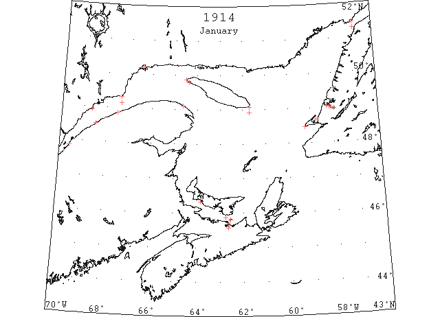
Jan 1 Coated heavily with ice from stem to stern, the steamer “Zeal [Seal]” reached port Sunday from Newfoundland and ports enroute, five days overdue. The passage of the “Seal” was on of the hardest ever experienced by Captain Murley, terrific gales from all quarters impeding the progress of the steamer all along the route of call. At Bonne Bay the ice was so much in evidence that it was impossible to get the steamer closer than ten miles to the proper landing place and more than fifteen passengers were forced to walk ten miles over the ice. Leaving her[e] on New Year’s day. The first called into on the Newfoundland coast was at Bay of Islands and in order to reach the landing there it was necessary to steam through several miles of solidly packed ice. (HH 20/01/1914 p11#5)
Jan 1 Crane Island: heavy packed ice. Father Point: light packed ice inshore. Matane: ice making fast everywhere. (HB 1271 Jan 7 CSS)
Jan 2 Point Amour: light open ice everywhere. Fame Point: light open ice everywhere. (HB 1271 Jan 7 CSS)
Jan 3 Belle Isle: three bergs. L’Islet: heavy open ice everywhere. Father Point: light open ice moving east. Fame Point: light open ice. Point Amour: straits full of thin slob ice. (HB 1272 Jan 14 CSS)
Jan 4 Father Point: light open ice inshore moving west. Belle Isle: light close packed ice distant. (HB 1272 Jan 14 CSS)
Jan 5 Fame Point: light open ice everywhere. Matane: ice packed inshore. (HB 1272 Jan 14 CSS)
Jan 6 Father Point: light open ice everywhere. Fame Point: light open ice everywhere. Matane: ice moving east. Point Amour: light close packed ice distant moving south. (HB 1272 Jan 14 CSS)
Jan 7 The harbor was caught over for the first time last night. (TWS, pg. 1, Col. 5)
Jan 7 Fame Point: light open ice everywhere. Matane: heavy open ice moving east. Point Amour: light open ice everywhere. Belle Isle: light close packed ice distant. (HB 1272 Jan 14 CSS)
Jan 8 Father Point: close packed ice. Fame Point: light open ice everywhere. Point Amour: light open ice everywhere moving west. Belle Isle: one berg. (HB 1272 Jan 14 CSS)
Jan 9 L’Islet: heavy open ice. Matane: heavy open ice everywhere. Father Point: light packed ice everywhere. Belle Isle: light close packed ice inshore. (HB 1273 Jan 21 CSS)
Jan 10 Matane: ice moving west. Point Amour: light close packed ice distant, moving west. Belle Isle: light close packed ice distant. (HB 1273 Jan 21 CSS)
Jan 12 L’Islet: river covered with ice. Father Point: light close packed ice. Fame Point: heavy close packed ice everywhere. Belle Isle: two bergs. (HB 1273 Jan 21 CSS)
Jan 13 Father Point: light close packed ice. Fame Point: heavy open ice everywhere. Point Amour: light close packed ice distant, moving west. Belle Isle: light close packed ice distant; two bergs. (HB 1273 Jan 21 CSS)
Jan 14 The Humber Sound is now bridged by a sheet of ice ranging from 2 to 5 inches in thickness (TWS p 2, Col.4)
Jan 14 Halifax, today the steamer “Stanley” inaugurates the winter mail service to the Magdalen Islands, leaving Sydney on the arrival of the mail train. Upon the arrival of the “Stanley” the islanders will receive their first postal communication from the outside world since the close of navigation about the first of December. This will be one of the earliest, if not the earliest, date for the delivery of the mails in the history of the Magdalens. During the winter months the islands are fringed with great ice fields that forbid navigation and often the inhabitants have been long periods without the mails although in recent years wireless and the cable heave afforded daily communication with the mainland. (HH 15/01/1914 p11#5)
Jan 14 The “Earl Grey” arrived here from New Glasgow, N.S. There was ice all the way to the east end of Pictou Island. (Pat 14 Jan p2#4)
Jan 14 The recent cold spell has been followed by the formation of a considerable quantity of ice in the Straits, and the “Minto” had a hard time of it yesterday. She arrived at Tormentine at 3:45 p.m. and left again at 5:00 on return to Summerside. She got stuck in the ice off Sea Cow Head and did not dock until 4:00 this morning. (Pat 15 Apr p1#3)
Jan 14 L’Islet: river covered with ice. Matane: heavy, close packed ice everywhere. Heath Point: light close packed ice distant. Point Amour: light close packed ice distant. (HB 1273 Jan 21 CSS)
Jan 15 L’Islet: river covered with thin ice. Matane: close packed ice everywhere. Fame Point: heavy close packed ice everywhere. (HB 1274 Jan 28 CSS)
Jan 16 L’Islet: heavy open ice. Fame Point: heavy open ice everywhere. Father Point: light open ice. (HB 1274 Jan 28 CSS)
Jan 17 L’Islet: open ice. Matane: heavy open ice everywhere. Fame Point: heavy close packed ice everywhere. Heath Point: heavy close packed ice distant, moving south. Father Point: heavy close packed ice everywhere stationary. Bersimis: ice everywhere. Point Amour: light open ice everywhere, moving west. Belle Isle: light close packed ice distant. (HB 1274 Jan 28 CSS)
Jan 20 The straits are full of heavy ice. (Pat 20 Jan p8#4)
Jan 20 Passengers who arrived on the “Minto” yesterday testify to the excellent work done by that steamer against the closely packed ice. She left Pictou at 7:00 am on Monday and it took all day to get six miles. The battle was continued during the entire night, and three more miles were covered. By noon, open water was reached and it was then full steam ahead for Georgetown. (Pat 2 Jan p5#3)
Jan 21 The recent northerly gales have brought along the drift ice, and now the coast to Cape St. George is blocked. (TWS, pg. 2, Col. 2)
Jan 21 On Saturday the ice in Humber Arm extended to John’s Beach. (TWS, pg. 3, Col. 3)
Jan 24 Matane: ice moving east. Fame Point: heavy open ice everywhere. Father Point: heavy packed ice inshore. Fame Point: heavy open ice everywhere. Point Amour: light close packed ice distant. (HB 1275 Feb 4 CSS)
Jan 25 Point Amour: light close packed ice distant. (HB 1274 Jan 28 CSS)
Jan 26 Three fishing schooners from Halifax, including the “Frances S Willard,” from Halifax, are frozen in at Bay of Islands, Nfld., where they were being loaded with herring. The vessels were imprisoned on Thursday by ice floes drifting from the Gulf of St. Lawrence, and it is feared the trio will not be able to work free again until spring. The last time the fleet was caught on the Newfoundland coast was in 1912, although most of them later succeeded in getting to sea after forcing their way thru the ice-floes. (HH 26/01/1914 p11#3)
Jan 26 Father Point: heavy close packed ice. L’Islet: heavy open ice everywhere. (HB 1275 Feb 4 CSS)
Jan 27 Father Point: heavy close packed ice. Matane: light open ice inshore. Fame Point: heavy open ice everywhere. Pointe des Monts: light open ice inshore. (HB 1275 Feb 4 CSS)
Jan 28 Now that Port au Port Bay is filled with ice, it looks as though the smelt industry… is at an end for this season. (TWS, pg. 2, Col. 3)
Jan 28 Father Point: heavy close packed ice. Fame Point: heavy open ice everywhere. Rivière du Loup: very little ice. Point Amour: light open ice inshore. Belle Isle: light close packed ice distant; four bergs. (HB 1275 Feb 4 CSS)
Jan 29 Father Point: heavy close packed ice. Matane: ice everywhere. Fame Point: heavy open ice everywhere. West Point: North Channel, light open ice inshore; South Channel, heavy close-packed ice inshore. Seven Islands: ice still solid to the outer end of the island. Belle Isle: light close packed ice distant; four bergs. (HB 1275 Feb 4 CSS)
Jan 30 Father Point: heavy open ice. Matane: heavy open ice everywhere moving west. Fame Point: heavy open ice everywhere. Pointe des Monts: light open ice distant. West Point: South Channel, light close packed ice. Ellis Bay: heavy packed ice. Heath Point: heavy close packed ice inshore. (HB 1275 Feb 4 CSS)
Jan 31 L’Islet: heavy close packed ice everywhere. Father Point: heavy close packed ice everywhere. Matane: ice packed everywhere. Fame Point: heavy close packed ice everywhere. Seven Islands: bay still solid. Belle Isle: four bergs. (HB 1276 Feb 11 CSS)
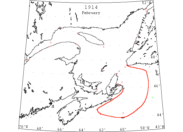
Feb 1 L’Islet: river covered with ice. Cape Salmon: very little ice. Matane: ice packed everywhere. Fame Point: heavy close packed ice everywhere. West Point: North Channel, heavy open ice; South Channel, light open ice. Heath Point: heavy close packed ice distant; heavy close packed ice everywhere. Pointe des Monts: light open ice distant, moving west. Seven Islands: bay still solid. Point Amour: heavy close packed ice everywhere moving west. (HB 1276 Feb 11 CSS)
Feb 3 L’Islet: river partly clear. Father Point: heavy close packed ice everywhere. Matane: packed ice everywhere. Heath Point: heavy close packed ice distant; heavy close packed ice everywhere. Pointe des Monts: light open ice distant. Seven Islands: bay still solid. Point Amour: heavy close packed ice everywhere moving west. Belle Isle: light close packed ice distant. (HB 1276 Feb 11 CSS)
Feb 5 Curling: U.S. naval tug “Potomac” failed to free the ice bound fishing schooners “Hiram Lowell” and “Frances Willard” in the Bay of Islands today. The tug narrowly escaped being caught in the ice which was driven in heavily from the Gulf of St. Lawrence before a NW gale. (NYMR)
Feb 10 L’Islet: light open ice. Rivière du Loup: heavy open ice. Father Point: heavy close-packed ice everywhere. Matane: ice packed everywhere. Fame Point: heavy close-packed ice everywhere. Flat Point: light open ice inshore. Seven Islands: bay still solid. Belle Isle: heavy close-packed ice. Five bergs. (HB 1277 Feb 18 CSS)
Feb 11 Bonne Bay, Nfld., several of the crew of the American naval tug “Potomac,” which is fast in the ice off here, came ashore today and are at Lobster [Cove] Head light station. The light-keeper at Lobster Head sighted the “Potomac” miles north, northwest of the light early yesterday. The vessel was jammed in the ice and showed signals which, however, could not be read because the flags were flying direct from the viewpoint at the station. When night fell the vessel had drifted considerably northward and bore north by west of the light station. The men arriving here made their way over the ice to the shore this forenoon. (HH 12/02/1914 p1#2)
Feb 13 Canadian Signal Service reports: L’Islet, heavy close packed ice everywhere; Riviere du Loun [Loup], heavy open ice; Father Point, heavy close packed ice everywhere; Matane, ice packed everywhere; Fame Point, heavy close packed ice everywhere; Flat Point, light open ice everywhere; Seven Is., bay still solid; Point Amour, heavy close packed ice distant. (NYMR 25 Feb)
Feb 16 Canadian Signal Service stations report: Rivier du Loup, heavy open ice; Father Point, heavy close packed ice everywhere, stationary; Fame Point, heavy open ice; Heath Point, heavy close packed ice everywhere; Flat Point, heavy close packed ice inshore; Belle Isle, heavy close packed ice everywhere, 4 bergs. (NYMR 4 Mar)
Feb 20 Halifax, The government steamer “Stanley” returned from sea this morning after quite an eventful trip. She left here before the big storm came on for Sable Island via Sydney, going to the latter port to assist in breaking the ice. When the storm came on it played havoc with some of the large coast buoys and the “Stanley” was ordered to look after them. Besides attending to the buoys she cut two steamers out of the ice. It was Thursday morning when she reached Sable Island and found the landing very favorable for this season. He [the keeper John Grigoire] says there is an ice wall on the north side of the main island and ice about half a mile off shore. The weather has been very severe on the island, the thermometer reaching zero, which is something unusual. It is expected that the hard weather will kill off many of the ponies. (HH 21/02/1914 p13#3)
Feb 21 SS “Lackawanna” 45°14’N 56°55’W passed 2 bergs ~150′ in diameter. (NYMR 11Mar)
Feb 21 L’Islet: light open ice. Rivière du Loup: heavy open ice. Father Point: heavy close-packed ice everywhere stationary. Fame Point: heavy open ice everywhere. Cape Ray: heavy close-packed ice distant moving SW. Flat Point: heavy close-packed ice distant. Light close-packed ice inshore. Money Point: heavy close-packed ice inshore. Seven Islands: bay still solid. (HB 1278 Feb 25 CSS)
Feb 22 Canadian Signal Service Stations report: Matane, ice making fast; Point Amour, heavy close packed ice distant, moving east; Belle Isle, heavy close packed ice everywhere, 3 bergs. (NYMR 4 Mar)
Feb 23 At 8:00 the “Earl Grey” left Pictou for Georgetown with 24 passengers and mails. At 9:00 the “Minto” was stuck in heavy ice five miles off Cape Bear. (Pat 23 Feb p5#4)
Feb 24? SS “Minia” passed 50m of Gulf field ice off Bank Queno [Banquereau]. Off Louisburg the ice has imprisoned a large fleet of steamers and sailing vessels. (NYMR 4 Mar)
Feb 24 SS “Bergensfjord” 44°16’N 62°08’W for 4 hours passed through field ice; near Sable Is, some heavy pieces were sighted. (NYMR 4 Mar)
Feb 25 SS “Armenia” at Halifax from Hamburg sighted field ice 40m off shore. (NYMR 4 Mar)
Feb 25 At noon today, the “Earl Grey” was on the move and expected to dock in Pictou today. The “Minto” was still stuck off Cape Bear. (Pat 25 Feb p5#2)
Feb 26 Belle Isle, light open ice everywhere. (NYMR 11Mar)
Feb 26 Belle Isle: light open ice everywhere. Three bergs. (HB 1279 Mar 4 CSS)
Feb 27 Canadian Signal Service reports: L’Islet, river clear; Riviere du Loup, heavy open ice; Father Point, open ice inshore; Matane, light open ice; Fame Point, heavy close packed ice everywhere; West Point, very little ice; Heath Point, heavy close packed ice distant; Money Point, heavy close packed ice inshore; Magdalene Is., heavy close packed ice everywhere; Cape Ray, heavy close packed ice everywhere; Flat Point, heavy close packed ice everywhere, moving SE; Seven Is., bay still solid; Point des Monts, light open ice distant; Point Amour, heavy close packed ice distant moving W. (NYMR)
Feb 27 L’Islet: river clear. Rivière du Loup: heavy open ice. Father Point: open ice inshore. Matane: light open ice. Fame Point: heavy close packed ice everywhere. West Point: very little ice. Heath Point: heavy close packed ice distant. Money Point: heavy close packed ice inshore. Magdalen Islands: heavy close packed ice everywhere. Cape Ray: heavy close packed ice everywhere. Flat Point: heavy close packed ice everywhere moving SE. Seven Islands: bay still solid. Pointe des Monts: light open ice distant. Point Amour: heavy close packed ice distant moving west. (HB 1279 Mar 4 CSS)
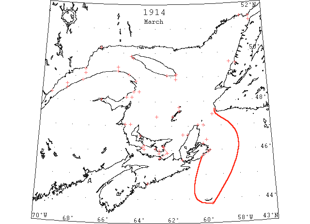
Mar 1 The “Minto” which left Georgetown on Sunday morning succeeded in reaching Pictou at 1:00 pm the same day, the southwest wind loosening the ice and making conditions favourable for crossing. She left at 7:00 am today for Georgetown. At 11:00 she was 11 miles south east of Cape Bear moving slowly in very heavy ice. (Pat 3 Mar p8#2)
Mar 2 Harbor Point – Light open ice inshore. Fame Point – Heavy open everywhere. Anticosti and Heath Point – Heavy close packed everywhere. Cape Ray – Heavy open ice everywhere. Point Escuminac – Heavy close packed everywhere. Flat Point – Heavy close packed distant. Magdalen Islands, Grosse Island – Heavy open ice everywhere. Grindstone – Heavy close packed everywhere. (HH 03/03/1914 p11#3)
Mar 2 Halifax, considerable apprehension is felt in local shipping circles regarding the safety of the steamer “Easington” and those on board. The “Easington,” under sailed from Yarmouth for Louisburg on Saturday, February 21st and under ordinary conditions should have reached her destination Sunday night. Reports recently received in the city were to the effect that the “Easington” was caught in the ice outside of Louisburg. Latest advices received, it was reported were to the effect that the “Easington” was in the ice somewhere off the Cape Breton coast in a disabled condition owing to the blades of her propeller coming in contact with the ice. (HH 04/03/1914 p13#7)
Mar 4 Canadian Signal Service Stations: L’Islet and Riviere du Loup, no ice; Father Point, light open ice; Matane, heavy open ice everywhere, moving W; Point Manquereau, heavy open ice; West point, heavy open ice inshore; Ellis Bay, no ice outside bay; Money Point, heavy open ice inshore; Magdalen Is., heavy close packed ice everywhere; Gross Isle, heavy close packed ice, moving W; Cape Traverse, heavy open ice distant; Cheticamp, ice off shore; Cape Ray, heavy open ice distant; Flat Point, heavy close packed ice everywhere, stationary; Point Amour, heavy close packed ice distant; Belle Isle, light close packed ice distant, 2 bergs. (NYMR 11Mar)
Mar 4 Louisburg, Mate Saborne and three sailors of steamer “Easington” landed near Gabarus Cape yesterday morning. They report having left their ship at two o’clock Monday to ascertain their position form Guyon Island light and report the ship short of coal and water. They were unable to make land or return to their ship on account of storm wind and after spending the night in an open boat they were rescued from the ice yesterday morning. They also report two other ships caught in the ice near Fourchu. (HH 05/03/1914 p11#6)
Mar 4 Father Point – Light, open ice, distant. Money Point – Heavy, open ice, inshore. Cape Ray – Heavy, open ice, distant. Point Amour – Blinding snow storm, gale east. Magdalen Islands – Heavy closed packed ice, moving west. Cape Traverse – Heavy ice, distant. Cheticamp – Ice off shore. (HH 05/03/1914 p11#6)
Mar 4-15 Gloucester, Mass., Mar 15.- … fishing schooner “John Hays Hammond”, that arrived today from a fishing trip, reports … On Mar. 4 he sailed for home over the northern edge of the Grand Bank, over Green Bank, St. Pierre Bank, and Quero Bank [Banquero], coming close to and south of Sable Island, and over that stretch saw no ice. He spoke with several fishermen on the above banks, all of whom reported seeing no ice. [Report by Mr. Geo. W. Scott, Gloucester, Mass.] (HB 1282 Mar 25)
Mar 5 Point Amour, heavy close packed ice distant; Belle Isle, light close packed ice distant, 2 bergs. (NYMR 18 Mar)
Mar 6 Halifax, a private message received at Halifax yesterday afternoon reports that the United States naval tug “Potomac” which was abandoned ice-bound off Bonne Bay, Nfld., a short time ago, had drifted 20 miles further south of where she was last reported. Her present position is about ten miles northwest of Trout River, and she is drifting in close packed ice. (HH 06/03/1914 p11#4)
Mar 6 Fame Point – Heavy open ice everywhere. Anticosti – Open ice inshore. Point Misquash – Large open ice, inshore. Magdalen Islands – Heavy close packed ice everywhere. Money Point – Heavy packed ice everywhere. Flat Point – Heavy close packed ice everywhere. Cape Traverse – Heavy, open ice distant. (HH 07/03/1914 p15#4)
Mar 9 Fame Point, Point Maquereau – Heavy open ice everywhere. Cape Despair, Point Escuminac south, Heath Point, Anticosti, Grindstone, Magdalen Islands – Heavy close packed ice everywhere. West Point, Anticosti – Light, close packed inshore. South Channel – Heavy open ice everywhere. North Channel, Grosse Isle, Magdalen Islands – Heavy open ice, distant. Cape Traverse – Heavy open ice, distant. Point Tupper – No ice. Cape Ray – Dense fog. Money Point – Light close packed ice inshore. Flat Point – Heavy close packed ice distant. (HH 10/03/1914 p13#3)
Mar 9 Ships entering and leaving the ports of Georgetown and Pictou. (Pat 9 Mar p8#4)
Mar 13 Canadian Signal Service reports; L’Islet, no ice; Riviere du Loup, no ice; Matane, heavy open ice everywhere; Father Point, no ice; Cape Magdelen, heavy close packed ice everywhere, Fame Point, light open ice everywhere; Point Escuminac, heavy close packed ice everywhere; Pointe des Monts, heavy close packed ice everywhere; West Point, light scattered ice; South Point, light open ice inshore; Heath Point, heavy open ice everywhere; Cape Ray, no ice; Money Point, heavy close packed ice distant; Flat Point, heavy close packed ice stationary; Scatari, heavy close packed ice everywhere; Point Amour, heavy close packed ice distant, moving west. (NYMR 25 Mar)
Mar 13 Halifax, the “Louisburg,” one of the ships arriving yesterday from Louisburg, reported large fields of slob ice, many of these slobs were of large size, some of them being hundreds of feet in length and breadth. The “Louisburg” was forced to reduce speed. (HH 13/03/1914 p5#6)
Mar 13 Quebec to Father Point – Very little ice. Matane, Cape Despair, Point Escuminac, Point Desmonts, East Scatari – Heavy close packed ice, everywhere. Cape Magdalen, Cape Maquereau, Heath Point, Grindstone – Heavy open ice everywhere. West Point, Anticosti, Point Tupper – No ice. Fame Point, South Point, Anticosti – Light open ice everywhere. Grosse Isle, Magdalens – Heavy open, distant. Cheticamp – Light open, inshore. Cape Ray – Light close packed distant. Money Point – Light close packed ice inshore. Flat Point – Heavy close packed ice distant. (HH 13/03/1914 p15#6)
Mar 14 SS “Batsford” at Halifax from Sunderland via Louisburg had hull and propeller damage off Halifax. (NYMR)
Mar 16 It is expected that the winter steamers will try for Charlottetown as soon as there is a change of wind. Conditions are at present unfavourable the straits between Wood Islands and Point Prim being reported blocked with ice today. (Pat 16 Mar p8#3)
Mar 18 The Pontiac is at present off Bonne Bay in the grip of the ice floes, which are supposed to be 30 feet in thickness (TWS, pg. 1, Col. 5)
Mar 18 The Gulf fleet were on Thursday reported 40 miles off Grindstone Island, inside the Magdalene Islands. Ice was very heavy; no seals (TWS, pg. 2, Col. 3)
Mar 18 Cape Magdalen – Light close packed distant. Fame Point – Light open inshore. Cape Despair, West Point, South Point, Anticosti, Point Escuminac – Heavy close packed everywhere. Heath Point, Anticosti, Grindstone, Magdalen Islands, Scatari – Heavy open ice, everywhere. Grosse Isle, Magdalen Islands – Heavy open ice distant. Cape Tormentine – Light open ice. Point Tupper – No ice. Cape Ray – Light open ice everywhere. Money Point, Flat Point, Point Amour – Heavy close packed, distant. (HH 19/03/1914 p11#5)
Mar 19 Cape Magdalen – Scattered ice inshore. Point Escuminac, Scattarri, Point Amour – Heavy close packed ice everywhere. Point Maquereau, South and East Point, Anticosti, Cape Magdalen, Grosse Isle – Heavy open ice everywhere. Magdalen Islands, Cape Traverse, Cheticamp, Point Tupper – Light open ice, distant. Cape Ray – No ice. Money Point – Heavy close packed, distant. Flat Point – Heavy open ice distant. (HH 20/03/1914 p11#6)
Mar 19 Rivière du Loup: no ice. Matane: heavy open ice everywhere moving west. Cape Magdalen: light scattered ice. Pointe des Monts: heavy close packed ice everywhere moving west. South Point: heavy close packed ice everywhere. Heath Point: heavy open ice everywhere. Grindstone: heavy open ice everywhere. Grosse Isle: open ice distant moving east. Cape Traverse: heavy open ice. Cheticamp: ice off shore. Cape Ray: no ice. Money Point: heavy close packed ice distant. Flat Point: heavy open ice distant moving north. Scatari: heavy close packed ice everywhere. Point Amour: heavy close packed ice everywhere moving west. (HB 1282 Mar 25 CSS)
Mar 20 The “Earl Grey” left Pictou at 7:00 this morning for Charlottetown and as the wind is westerly it is hoped that she may be able to reach here. At noon she was off Point Prim, fighting heavy ice. (Pat 20 Mar p8#3)
Mar 21 The easterly wind is giving the steamers trouble today, as it has packed the ice on the Island shores. At 10:00 am the Grey bound to Pictou was off Cape Sharpe in heavy ice. The “Minto” at the same time was off Panmure Island, also stuck. (Pat 21 Mar p9#2)
Mar 23 Quebec to Matane – Very little ice. Cape Magdalen, Point Maquereau – Heavy open ice everywhere. Point Escuminac, Money Point – Heavy close packed inshore. Point Desments, Grosse Isle – Heavy close packed, distant. Grindstone – Open ice, everywhere. Cape Traverse – Open, distant. Point Tupper – No ice. Cape Ray – Light open ice, everywhere. Flat Point – Heavy open ice. (HH 24/03/1914 p13#4)
Mar 23 The Ice Boats Have Trying Experience – … The other three got caught in a large field of lolly and the rising gale compelled them to turn back and try to reach Cape Traverse. They were blown down the Straits and after a trying experience in the broken ice, eventually made land at Crapaud bout 11:00 at night. The failure of the three boats to get across was due to unavoidable circumstances. They were the last three in the line, and by the time they got through a stretch of lolly near the New Brunswick shore, the rising wind compelled Captain Allan to adopt the course that seemed safest to him, that was to get back to Cape Traverse. (Pat 23 Mar p1#7)
Mar 24 Halifax, reporting a tempestuous voyage, the steamer “Manchester Inventor,” from Manchester, arrived at Halifax yesterday morning. She encountered heavy head seas and terrific gales during the whole voyage. She also reported foggy weather and a large field of ice was sighted southeast of Sable Island. (HH 24/03/1914 p13#4)
Mar 25 Cape Magdalen – Heavy close packed everywhere. Fame Point – Light close packed everywhere. Cape Despair – Very little ice. Point Maquereau, Point Escuminac – Heavy open ice inshore. Point Tupper, Anticosti, Scattarri – No ice. Grindstone – Heavy open ice everywhere. Grosse Isle, Magdalen Islands – Heavy close packed ice everywhere, moving east. Cheticamp– Ice packed inshore. Cape Traverse – Strait full broken ice. Cape Ray – Light open ice everywhere. Flat Point – Heavy open ice distant. (HH 26/03/1914 p11#4)
Mar 26 Cape Magdalen, Fame Point, Cape Ray – Heavy open ice everywhere. Point Maquereau, Grindstone – Heavy open ice everywhere. Cape Despair, Point Escuminac – Heavy close packed ice distant. Grosse Isle, Magdalen – Heavy open ice moving east. Heath Point, Anticosti – Heavy open distant. West, Southwest and South Point – No ice. Money Point – Heavy close packed, inshore, stationary. Flat Point – No ice. Scattarri – Clear variable, heavy close packed northward; heavy open ice everywhere, southward. (HH 27/03/1914 p11#3)
Mar 26 Cape Magdalen: heavy open ice everywhere. Fame Point: light open ice everywhere. Point Maquereau: heavy open ice everywhere. Point Escuminac: heavy close packed ice distant. Seven Islands: bay still solid. Heath Point: heavy open ice distant. Grindstone: heavy open ice everywhere. Grosse Isle: heavy open ice moving east. Cape Ray: light open ice everywhere stationary. Money Point: heavy close packed ice inshore. Heavy close packed ice stationary. Scatari: heavy close packed ice. Point Amour: heavy close packed ice everywhere moving SE. Belle Isle: light close packed ice stationary. (HB 1283 Apr 1 CSS)
Mar 28 The twenty-eighth of March in the year 1914 will be memorable as the day upon which the magnificent ice fighting steamer “Earl Grey” came into the harbour of Charlottetown. It was the eighteenth of March last year, ten days earlier than this season. (Pat 28 Mar p4#4)
Mar 31 Cape Magdalen, Fame Point, – Light open ice everywhere. Point Maquereau – Heavy close packed distant. Point Edesmont, West, Southwest and South Point, Anticosti, Point Tupper – No ice. Grindstone, Grosse Isle, Magdalen Islands, Cape Ray, Money Point, Scattarri – Blinding snow storms. (HH 01/01/1914 p13#4)

Apr 1 Cape Magdalen, Fame Point – Light open ice everywhere. Cape Despair – Very little ice. Point Maquereau, Point Escuminac – Heavy close packed, distant. Anticosti, Heath Point – Heavy open distant. Scattarri – heavy, close packed, northeast. Grindstone – Heavy open everywhere. Grosse Isle, Magdalen Islands – Heavy close packed everywhere, stationary. Point Tupper, Cape Ray, West to South Point, Magdalen Islands, Anticosti – No ice. Flat Point – Heavy close packed everywhere; stationary. Amherst Harbor – Island surrounded with ice as much as ever; no bait. Souris – Heavy packed ice north coast; no ice eastern coast, except bay; no herring. Queensport – No ice. (HH 02/04/1914 p11#6)
Apr 1 The “Minto” docked in Georgetown today. The “Earl Grey” was expected to dock in Pictou at noon. The “Minto” intended to come here but owing to the ice conditions was obliged to change her plans. (Pat 1 Apr p8#3)
Apr 3 Canadian Signal Service: Cape Magdelen, light open ice; Fame Point, light open ice everywhere; Point Maquereau, heavy open ice everywhere; Point Escuminac, heavy close packed ice inshore; Heath Point, heavy open ice distant; Entry Island, heavy close packed ice everywhere; Grindstone, heavy close packed ice stationary; Grosse Isle, heavy close packed ice stationary; Cape Tormentine, heavy close packed ice everywhere; Cape Traverse, ice 5 miles off; Money Point, heavy close packed ice inshore; Flat Point, heavy close packed ice everywhere; Scatari, heavy close packed ice everywhere; Point Amour, heavy close packed ice distant, light open ice inshore moving west. (NYMR 15 Apr)
Apr 3 Halifax, the ice conditions in the vicinity of Louisburg and North Sydney are again proving a serious handicap to navigation and several steamers, including two government boats, are held up. The steamer “Stanley” which left Louisburg a week ago for the Magdalen Islands has not yet been successful in getting there. C H Harvey received work last night to the effect that the “Stanley” was fifteen miles southeast of the Magdalen’s and is expected that she will be able to reach port tonight. Mr. Harvey also received word that ice is beginning to close in the vicinity of Louisburg. The steamer “Bruce,” from Port Aux Basque, was reported last night to be five miles off North Sydney and unable to reach there owing to ice conditions. The steamer “Minto” is unable to leave North Sydney for the same reason. (HH 04/04/1914 p15#6)
Apr 4 Quebec to Fame Point – Very little ice. Point Maquereau – Heavy open ice everywhere. Point Escuminac, Money Point – Heavy, close packed inshore. West to South Point, Anticosti, Point Tupper – No ice. Grindstone, Grosse Isle, Magdalen Islands, Cape Tormentine, Scattarri, Flat Point – Heavy close packed everywhere. Cape Traverse – Ice five miles off. Cape Ray – Blinding snow storm, gale northwest. Heath Point, Anticosti – Heavy open ice distant. (HH 04/04/1914 p15#7)
Apr 6 Martin River, Cape Magdalen, Cape Traverse – Light, scattered ice. Point Maquereau, Point Escuminac, Grindstone, Scattarri – Heavy open ice everywhere. Grosse Isle, Magdalen Islands, Cape Tormentine, Cape Ray, Money Point, Flat Point, Point Amour – Heavy close packed everywhere. Cape Bear – Loose ice, inshore. Fame Point, Cape Despair, Point Edesmonts, Anticosti – No ice. Steamer “Stanley” 15 miles southwest of Cape North 3 a.m. reports heavy close packed ice everywhere, bound Louisburg. (HH 07/04/1914 p13#6)
Apr 7 Canadian Signal Service: L’Islet, river partly clear; Cape Magdelen, light scattered ice; Grosse Isle, heavy close packed ice moving E; Cape Tormentine, heavy open ice everywhere; Cape Traverse, light scattered ice; Cape Ray, heavy open ice moving SE; Money Point, heavy close packed ice moving SE; Flat Point, heavy close packed ice everywhere moving SE. (NYMR 15 Apr)
Apr 7 “Seneca”: Cruised between Banks and Gulf north to 43°30’N; saw no ice. (NYMR 15 Apr)
Apr 7 Halifax, a wireless report received last evening states that the sealing steamer “Seal” was 25 miles south of Entry Island, in the Magdalens and is now free from the ice, where she had been jammed. (HH 07/04/1914 p13#6)
Apr 8 Quebec to Cape Rosier and Anticosti, Bersisnis, Point Edesmonts, Point Tupper, Cape Race – No ice. Cape Despair, Point Maquereau, Point Escuminac, Grindstone – Heavy open ice everywhere. Grosse Isle, Magdalen Islands, Cape Tormentine, Cape Ray, Point Amour – Heavy close packed everywhere. Money Point, Scattarri – Heavy close packed inshore. Cape Bear – Heavy ice, inshore. Cape Traverse – Heavy ice, distant. (HH 09/04/1914 p11#5)
Apr 9 Halifax, the steamer “Bruce” arrived at Louisburg Tuesday and sailed in the afternoon for Port Aux Basque. The “Lintrogg” was reported in the ice Tuesday about seven miles off Low Point trying to make North Sydney. The ice condition[s] are still unfavorable. (HH 09/04/1914 p11#6)
Apr 9 Grindstone, Cape Bear, Cheticamp – Heavy open ice everywhere. Grosse Isle, Magdalen Islands – Heavy open ice, distant. Anticosti, Point Tupper – No ice. Cape Race, Cape Ray – Dense fog. Cape Tormentine, Money Point – Heavy close packed ice everywhere. Flat Point – Heavy, close packed distant. (HH 11/04/1914 p15#5)
Apr 11 SS “Erodiade” 32°55’N 62°11’W apparently river ice about the size of a lifeboat. (JH).
Apr 11 Canadian Signal Service: L’Islet, very little ice; Point Escuminac, heavy close packed ice distant; Grindstone, heavy open ice everywhere; Grosse Isle, heavy open ice moving E; Cape Tormentine, heavy close packed ice everywhere; Cape Bear, light scattered ice in shore; Cape Ray, heavy close packed ice everywhere, stationary; Money Point, heavy close packed ice everywhere; Flat Point, heavy close packed ice everywhere, moving SE; Scatari: Heavy close packed ice everywhere. (NYMR 22 Apr)
Apr 13 J.A. Ward, Lightkeeper, Miscou Point, New Brunswick: Opening date. (CIS IC0756)
Apr 13 Grindstone – Heavy open everywhere. Grosse Isle – Heavy close packed, stationary. Cape Traverse – Light, scattered everywhere. Point Tupper – Light, scattered inshore. Cape Bear – Loose ice, everywhere. Cape Ray – Snow storm. Money Point, Flat Point – Heavy, close packed, distant. Scatteri – Light, open inshore. Anticosti – No ice. (HH 14/04/1914 p8#5)
Apr 14 Ice is reported as follows: Point Masquereau, heavy open ice; Grindstone, heavy open ice everywhere, Gross Isle, broken ice in shore; Cape Tormentine, light close packed ice inshore; Cape Traverse, heavy broken ice; Cape Ray: Heavy close packed ice everywhere, moving SE; Money Point, heavy close packed ice inshore; Flat Point, heavy close packed ice 10 miles off moving SE; Scatari; heavy open ice moving S; Point Amour; heavy close packed ice distant; Belle Isle, heavy close packed ice distant. (NYMR 22 Apr)
Apr 14 Queensport, no ice. Amherst Harbor, Etang du Nord, lots of ice, no bait. House Harbor, short ice solid yet; Amherst Harbor frozen also Pleasant Bay; ice seems to scatter. (HH 15/04/1914 p15#5)
Apr 15 There was good ice boating and skating on the ice of the Humber Arm the middle of last week. (TWS, pg. 2, Col. 4)
Apr 15 Point Maquereau – Ice everywhere. Point Escuminac, Grosse Isle, Magdalen Islands, Cheticamp – Light, open ice, inshore. Cape Tormentine – Light, close packed, inshore. Cape Bear, Anticosti – No ice. Cape Ray, Money Point – Heavy close packed everywhere. Flat Point, Scatteri – Heavy, close packed, distant. (HH 16/04/1914 p13#6)
Apr 15 Queensport, no ice. Amherst Harbor, Amherst no change since yesterday; Etang du Nord, seven miles shore ice, stationary; House Harbor, no change since yesterday; Grand Entry, ice ten miles off harbor, clear. (HH 16/04/1914 p13#3)
Apr 16 SS “Californie”, 45°20’N 57°46’W encountered field ice trending NNW and SSE as far as could be seen and was obliged to steer SSE to clear it. A few blocks of the ice were quite high and small growlers were seen in it. 45°15’N 57°34’W encountered field ice similar to the above and had to run 20 miles to the SSE to clear it, passing the southern extremity in 44°45’N 57°33’W. (HB #1287 Apr 29)
Apr 18 SS “Honoreva” 45°24’N 60°W saw field and slob ice extending as far to the eastward and southward as could be seen and to within 12 miles of the shore. (HB #1288 May 6)
Apr 20 Canadian Signal Service: Grindstone, heavy open ice distant; Cape Tormentine, light close packed ice inshore; Cape Traverse, light scattered ice in Straits; Grosse Isle, close packed ice inshore; Pleasant Bay, still jammed with ice; Point Tupper, loose ice in Straits; Cape Ray: Light open ice stationary; Money Point, heavy close packed ice, distant; Flat Point, heavy open ice distant moving SE; Belle Isle, slob ice; Scatarie, heavy open ice distant. (NYMR 29 Apr)
Apr 20 Souris, heavy ice Eastport and north coast, none here; Queensport, no ice. Amherst Harbor, – Drift ice seems to move away; Peasant Bay an harbor still frozen in same place; shore ice is going away; no bait. (HH 21/04/1914 13#4)
Apr 21 Canadian Signal Service: Cape Tormentine, light open ice, stationary; Cape Traverse, light open ice; Summerside Harbour, now open; Cheticamp, light open ice inshore; Point Tupper, strait full of ice; Flat Point, heavy open ice everywhere, moving S; Point Amour, heavy close packed ice, distant, moving S. Belle Isle, slob ice; 3 bergs. (NYMR 29 Apr)
Apr 21 Halifax, on the arrival of the steamer “Seal” from her sealing in the gulf on Saturday morning, her commander, Captain George Murley, reported a fair catch of seals. The “Seal” left Halifax on March 2 and proceeded to Channel, Nfld., via Louisburg, making a very good run up, and immediately on clearing Channel to commence operations met with many obstacles in the way of heavy ice, which delayed the vessel in reaching the sealing grounds. They did not sight the seals until March 17, and made their first catch on the following day, bagging some two thousand. On the 19th they were not quite so successful, killing only one thousand, and the next day taking some eight hundred. Captain Murley then decided to change his position and go in search of better luck, where they could “Put out a plank and let the seals walk aboard,” but his vessel stuck in heavy ice 45 miles northwest of Brian Island and was held there for three days. The captain said that the ice was in great fields four to five miles wide. When released from the ice the “Seal” shaped her course to the eastward and caught another 1,000 seals. She was stuck again in the ice at various times and finished up by being held fast for nearly two weeks. (HH 21/04/1914 p13#4)
Apr 22 The ice in the Humber Arm is cutting down very slowly. The water now extends to the railway pier. (TWS, pg. 2, Col. 3)
Apr 22 Grindstone, about 10 miles of open ice to the northward; no ice in sight south and west. Point Tupper, loose ice. Money Point, heavy close packed ice distant. Flat Point, heavy open ice everywhere moving SE. Scatari, heavy close packed ice distant moving S. Point Amour, heavy close packed ice distant moving W. (HB #1287 Apr 29)
Apr 22 Grindstone – Open ice northward; no ice southward. Cape Traverse – Ice distant. Cape Ray, Cape Verd, Anticosti – No ice. Point Tupper –Loose ice. Money Point, Scatarri – Heavy close packed, distant. Flat Point – Heavy, open ice everywhere. No change west of Quebec. (HH 23/04/1914 p15#4)
Apr 22 The “Heathcote” is still discharging her cargo of sand, after which she will probably sail for Sydney, although owing to ice conditions on the route between the two ports, it may be found expedient to embark her cargo of pig iron at the ancient and historic port. (HH 23/04/1914 p15#5)
Apr 22 Souris, Northeast wind; heavy ice, East Point and north coast; distant ice, Souris; no bait. Amherst Harbor – Loose ice around island yet, but moving down gulf shore, ice breaking up; ice in Pleasant Bay too solid; no bait. (HH 23/04/1914 p15#5)
Apr 23 Grindstone, ice drifting out of Pleasant Bay. Money Point, heavy close packed ice everywhere. Flat Point, heavy open ice everywhere moving SE. Scatari, ice about 2 miles from shore moving S. Point Amour, heavy close packed ice distant moving W. (HB #1287 Apr 29)
Apr 23 C.G.S. “Stanley”: 8 am, open water 3 miles offshore from White Point to Flint Island. Close packed ice both sides. Noon, 8 miles SE of Scatari Island, ice heavy, but loose to the S and E with some open water. (HB #1287 Apr 29)
Apr 23 C.G.S. “Earl Grey”: About 7 miles of ice along Nova Scotia shore extending to Cape Breton. (HB #1287 Apr 29)
Apr 23 SS “Lintrose”: Heavy loose ice from Channel Head to within 5 miles of Flat Point. (HB #1287 Apr 29)
Apr 23 Grindstone – No ice in sight. West Tormentine – Light, close packed, distant. Cape Bear, Cape Traverse, Anticosti, Grose Isle, Cape Ray – No ice. Flat Point – Heavy, open ice distant. Money Point – Heavy, close packed, everywhere. Point Tupper –Strait full of ice. Scatarri – Ice two miles from shore moving south. Steamer “Stanley” reports ice three miles off shore from White Point to Print [Flint] Island; close packed ice both sides. Steamer “Lintrose” reports heavy, close ice from Channel Head to within five miles of Flat Point. (HH 24/04/1914 p13#6)
Apr 23-24 C.G.S. “Minto”: George Bay packed with heavy ice. (HB #1287 Apr 29)
Apr 24 Point Escuminac, light close packed ice inshore. Grindstone. Ice inshore on N side ~4 miles; some ice in Pleasant Bay. Cape Traverse, half mile of broken ice in bay. No other ice to be seen. Cheticamp, ice on shore. Point Tupper, drift ice in strait. Money Point, heavy close packed ice everywhere. Flat Point, heavy open ice everywhere moving S. Scatari, heavy close packed ice distant. Point Amour, heavy close packed ice distant moving S. (HB #1287 Apr 29)
Apr 24 SS “Bruce”: Loose ice from 15 miles off Channel Head to within 10 miles of Cape Smoke. Open water from there to Flat Head. (HB #1287 Apr 29)
Apr 24 Magdalen Islands – Close, packed ice inshore, north side. Money Point – Heavy, close packed everywhere. Flat Point – Heavy open distant. Scatarri, Cape Ray – Heavy, close packed, distant. Point Tupper – Drift ice in strait. Cape Tormentine – Light open distant. Cape Traverse – Very little ice. Steamer “Minto” reports ice jammed in George’s Bay. Steamer “Earl Grey” reports ice in Northumberland Strait. (HH 25/04/1914 p15#3)
Apr 24 Amherst Harbor – Ice running further, Amherst Island, Pleasant Bay. Stationary up to Grindstone, Grand Entry harbor. Clear ice out of sight. (HH 25/04/1914 p15#6)
Apr 25 SS “Montfort” from Antwerp to Montreal in Cabot Strait entered heavy field ice apparently blocking the strait and along the Newfoundland shore east of Cape Ray to a distance of 30m; 26th, cleared the ice; Cabot Strait was apparently clear as far as could be seen to the S and W, but an ice field extended as far as could be seen along the NW shore of Newfoundland. (NYMR 6 May)
Apr 25 Grindstone, ~4 miles ice inshore on N side. Some board ice in Pleasant Bay. Cape Tormentine, light open ice distant. Cape Traverse, scattered ice in straits. Money Point, light open ice distant. Scatari, heavy close packed ice everywhere. Point Amour, heavy close packed ice distant. (HB #1288 May 6)
Apr 25 C.G.S. “Minto”: George Bay packed with heavy ice. (HB #1288 May 6)
Apr 25 C.G.S. “Earl Grey”: Strait full of ice from Pictou to Tormentine. (HB #1288 May 6)
Apr 25 “Touraine” 45°22’N 57°30’W, 1 am saw field ice ~8m distant; from 2 pm to 2:40 pm another field of ice. (NYMR & HB #1288 May 6)
Apr 25-29 C.G.S. “Stanley”: 25th, heavy close packed ice from Cape North to Bird Rocks. Wind NE, driving ice on shore. 27th[26th?] loose ice extends 6 miles off E side of St. Pauls Island. No ice between this and Cape Ray. Light scattered ice extends 20 miles from St. Pauls Island and to NW, which is the end of the Gulf pack. 27th, strip of open water about 15 miles wide from St. Pauls Island to Cape Anguille. Scattered loose ice coming down Gulf. 29th, Cabot Strait clear of ice from Cape Ray to within 6 or 7 miles of St. Pauls Island. Ships are having no difficulty navigating Strait night or Day. (HB #1288 May 6)
Apr 26 Canadian Signal Service: Point Escuminac, light close packed ice inshore; Point Amour, heavy close packed ice distant, moving west; Belle Isle, heavy close packed ice distant, 7 bergs. (NYMR 6 May)
Apr 26 Grindstone, ~4 miles ice inshore on N side. Point Amour, heavy close packed ice distant. (HB #1288 May 6)
Apr 26 SS “Stanley” reports: loose ice extends 6m off E side of St. Paul’s Is. No ice between this and Cape Ray. Light scattered ice extends from St. Paul’s Is. toward the NW, which is the end of the Gulf Pack. (NYMR)
Apr 27 Point Escuminac, light close packed ice inshore. Grindstone, ~4 miles ice inshore on N side. Some board ice in western side of Pleasant Bay. Cape Tormentine, light open ice distant. Grosse Isle, light close packed ice 2 miles wide inshore moving E. Scatari, heavy open ice. Point Amour, heavy close packed ice distant. Point Tupper, Straits full of ice. (HB #1288 May 6)
Apr 28 First arrival of season at Quebec. (WBB)
Apr 28 Halifax: SS “Nordkap”, rivets loosened in ice Harbour Breton to Louisburg. (NYMR)
Apr 28 Grosse Isle, scattered ice moving E. Cape Tormentine, light open ice distant. Cape Ray, light open ice distant moving E. Money Point, heavy close packed ice everywhere. Flat Point, heavy open ice distant. Point Amour, light close packed ice distant. (HB #1289 May 13)
Apr 28 C.G.S. “Stanley”: From St. Pauls Island no ice to eastward, light open ice along Cape Breton shore. (HB #1289 May 13)
Apr 28 SS “Lintrose” strip of loose ice from Cape Ray to within 50 miles of Flat Point, from that in light close packed ice. (HB #1289 May 13)
Apr 28 Halifax, the White Star liner “Teutonic,” bound for Montreal made her way up the gulf as far as Cape Ray, but was compelled by ice conditions to shape her course for Halifax. (HH 28/04/1914 p15#5)
Apr 28 Amherst Harbor – Loose ice moving away all the time, part of Pleasant Bay still frozen. (HH 29/04/1914 p11#3)
Apr 28-29 Drift ice having been reported in March and early April as far south as Sable Island, coming out of St. Lawrence gulf, I went north of that [Sable] island when we sailed from Halifax on April 28 [1914] to see what conditions were. We found no ice worth reporting. On the east side of Banquereau bank we did see a few scattered pieces of ice, but they were not dangerous. (from a May 18, 1914 report of Captain Johnston of the U.S. Revenue Cutter “Seneca” entitled, “Second ice-patrol cruise [of 1914]” addressed to The Honorable Secretary of the Treasury, Washington, D.C., U.S. National Archives and Records Administration, Archives I, College Park, Maryland, Record Group 37, Hydrographic Office, General Correspondence 1907-1924, Box 149, [Ice] Patrol Ship Reports, file 92506-2995psr, second item, p. 1 of 7 pp.)
Apr 29 There are 22 inches of good hard ice in Benoit’s Cove last week. (TWS, pg. 3, Col. 3)
Apr 29 Most of the snow that fell last week has since disappeared, but there is yet about 18 inches of ice in the Humber Sound. (TWS, pg. 3, Col. 3)
Apr 29 Grindstone, ~2 miles ice inshore on N side. Western part of Pleasant Bay still blocked. Scatari, ice moving off. Point Tupper, Straits full of ice. (HB #1288 May 6)
Apr 29 SS “Bruce”: Came through 35 miles loose ice 10 miles off Flat Point; ice close and heavy. (HB #1288 May 6)
Apr 29 House Harbor,– Loose ice disappearing. Pleasant Bay frozen from Sandy Hook head to Havre Aux Basques. Grand Entry, ice out of sight. (HH 30/04/1914 p15#5)
Apr 30 Grindstone, ~2 miles ice inshore on N side. Western part of Pleasant Bay still blocked. Money Point, heavy close packed ice everywhere. Scatari, heavy close packed ice everywhere. Point Tupper, Straits full of ice. (HB #1288 May 6)
Apr (probably late) SS “Pomeranian” 48°16’N 49°20’W an ice field, no passage to westward; recommend going well south to clear ice fields; passed through ~10m of fairly heavy field ice when ~20m NW of Cape Ray. (NYMR)
May 1 Grindstone, ~2 miles ice inshore on N side. Western part of Pleasant Bay still blocked. Grosse Isle, no ice. Money Point, heavy close packed ice inshore, heavy open ice distant. Scatari, heavy close packed ice everywhere. Point Tupper, Straits full of ice. (HB #1288 May 6)
May 1 SS “Lintrose”: Very little ice 50 miles SW of Channel Head. Met heavy close packed ice 35 miles off Flat Head. (HB #1288 May 6)
May 1-3 SS “Sargasso” 44°51’N 58°43’W encountered dense field ice, and May 2, 45°26’N 59°53’W dense field ice and May 3, 46°55’N 60°11’W passed the last of the field ice. (HB #1292 Jun 3)
May 2 Point Tupper, strait full of ice. Scatari, heavy close packed ice everywhere SE. Money Point, heavy close packed ice everywhere. Point Amour, heavy close packed ice distant moving E. (HB #1289 May 13)
May 3 Point Amour, heavy close packed ice distant; 4 bergs. (HB #1289 May 13)
May 4 Canadian Signal Service: Grindstone, 1 mile of ice inshore; Scatari, heavy close packed ice inshore; Cape Ray, loose strings distant; Money Point, heavy close packed ice inshore; Flat Point, heavy close packed ice everywhere; Point Amour, heavy close packed ice everywhere, moving west, 3 bergs; Belle Isle, heavy close packed ice distant, 3 bergs; C. Race, several small strings loose ice drifting SW. (NYMR 13 May)
May 4 SS “Wabana” 47°33’N 59°30’W and 5th , 45°57’N 59°42’W steamed through field ice. (HB #1289 May 13)
May 5 Point Tupper, strait packed with ice. Scatari, heavy close packed ice distant. Money Point, heavy close packed ice inshore. Flat Point, heavy close packed ice everywhere stationary. Point Amour, heavy close packed ice everywhere stationary. (HB #1289 May 13) (HB #1289 May 13)
May 6 The rain and hot sun of late have taken away considerable of the ice and snow. On Saturday the ice to Woods Island was considered unsafe to pass over. Some holes have appeared in the Humber Arm, present and should present favorable weather conditions continue it is quite likely the bridge will be entirely removed by the middle of the month. (TWS, pg. 3, Col. 1)
May 6 Point Tupper, strait clear of ice. Scatari, ice scattered all around. Money Point, heavy open ice inshore. Flat Point, heavy close packed ice everywhere stationary. Point Amour, heavy close packed ice everywhere; 3 bergs. (HB #1289 May 13) (HB #1289 May 13)
May 6 Sydney, on the arrival of the government steamer “Stanley,” at Sydney Monday, her commander, Captain Blois gave a very interesting account of the ice conditions this winter. The business of the “Stanley” this winter has been the carrying of the mails to the somewhat isolated islands and sea port towns of the eastern coast, the breaking up of ice packs and general patrol duty. Asked if the ice was heavy this season he said: “Yes, heavier than for many years. The ice on this coast is different from that in the straits because there the tide moves it twice a day. Here it is quieter but it shifts a great deal. One night on our recent trip to the Magdalens, we got jammed on a raft of ice just off the islands, and supposed we would have to stay there until daybreak, at any rate. We all turned in and at daybreak there was scarcely a cake of ice in sight. Another night while jammed in we shifted 5 points from our course. On being asked if there was much more ice to come down, he replied: “Not a cake. It is all down and twenty –fours hours of westerly wind would clear it all off the coast. You see from Gaspe to Cape Breton form a sort of a bight and the ice is packed there. All that is needed is a westerly wind.” Did you meet the “Bruce” or “Lintose” yesterday morning?” “Yes, the “Lintose” came in after us but the “Bruce” is stuck yet. She will likely get clear today.” “How about the Magdalens? Did you find it hard to land there?” “We did not land at all. We simply docked in the ice. They signalled us from the wireless station that a dock had been bushed out for us in the board ice which is pretty heavy up there, and after we got clear of the drift, a bit we simply ran tilt for this dock. The ice was very heavy. We had as many as sixteen teams alongside at one time and they didn’t even quiver. (HH 06/05/1914 p11#5)
May 6 Queensport, no ice. Amherst Harbor – Ice in Pleasant Bay breaking up; ice in sight south of Amherst Island; Grindstone, broken ice on shore. (HH 07/05/1914 p11#3)
May 7 SS “Victorian” about 10 miles N of Bird Rocks, a small patch of field ice, and about 15 miles N of Bird Rocks, a small patch of ice 3 miles long. (HB #1290 May 20)
May 8 SS “Montfort” about 30 miles WNW of Cape Ray passed a patch of field ice about 2 miles in extent; 47°32’N 60°12’W an extensive patch of field ice. (HB #1293 Jun 10)
May 8 SS “Jacona” an open field about 20 miles N 69° E of Great Bird Rock. (HB #1290 May 20)
May 8 Grindstone, western part of Pleasant Bay still packed with ice. Point Tupper, strait packed with ice. Scatari, light close packed ice inshore. Point Amour, heavy open ice inshore, close packed ice distant. (HB #1289 May 13)
May 9 Canadian Signal Service: about 30 miles NW Cape Ray, field ice extending 20 miles. (NYMR 20 May p. 11, col. 2)
May 9 Point Tupper, strait packed with ice. Money Point, light open ice inshore moving N. Cheticamp, still blocked with drift ice along shore. Scatari, ice floating off and scattered. Flat Point, heavy close packed ice inshore stationary. (HB #1289 May 13)
May 11 Canadian Signal Service reported ice as follows: – Cheticamp, drift ice moving north outside, but mouth of harbor barricaded with grounded ice; Money Point, light open ice distant; Flat Point, heavy open ice distant, moving southeast; Point Amour, heavy close packed ice everywhere, two bergs. (NYMR 20 May p. 11, col. 1)
May 11 SS “Athenia” from 43 miles W of Cape Ray to 2 miles E of Bird Rocks steamed through 29 miles of detached field ice. (HB #1293 Jun 10)
May 12 Flat Point, heavy open ice distant, moving southeast. (HB #1290 May 20)
May 13 Lark Harbor on Monday reported drift ice 4 miles off, with the bay inside full. It is now all open water in the Humber Arm, but there is a bar of ice across the Bay from Woods Island. The ice in the Humber Arm moved off shore on Sunday, and the rain on that and the following day melted most of it. (TWS, pg. 2, Col. 5)
May 13 Issue: SS “Athenia” passed through open field ice from Cape Ray to 25 miles westward. (NYMR 13 May)
May 13 Str. “Pomeranian” reports… passed through about 10 miles of fairly heavy field ice when about 20 miles NW of Cape Ray. [probably late April] (NYMR, p. 10, col. 5)
May 13 Flat Point, heavy open ice everywhere, stationary. Point Tupper, strait full of ice. Money Point, open ice inshore. Point Amour, heavy open ice distant, 1 berg. Scatari, heavy close packed ice NE within 2 miles off shore. (HB #1290 May 20)
May 14 Flat Point, heavy open ice everywhere moving N. Point Tupper, strait clear of ice. Point Amour, heavy close packed ice distant. Scatari, scattered ice about ½ mile off shore. (HB #1290 May 20)
May 15 Flat Point, heavy open ice everywhere moving SE. Point Amour, heavy open ice everywhere, moving W. (HB #1290 May 20)
May 16 Flat Point, heavy open ice everywhere. Point Tupper, strait clear of ice. Money Point, light open ice distant. Point Amour, heavy open ice everywhere stationary, 2 bergs. (HB #1290 May 20)
May 16 Halifax, one hundred fishing schooners, bound north for bait were reported to have been caught fast in drift ice in the strait of Canso while on their way to the Gulf of St. Lawrence. Some of the schooners were said to be in danger of being crushed in the heavy floes. (HH 18/05/1914 p11#5)
May 18 Flat Point, heavy open ice distant. Point Tupper, strait clear of ice. Scatari, scattered ice. Point Amour, heavy open ice everywhere. (HB #1291 May 27)
May 19 SS “Kendall Castle” arrived at Montreal with forepeak filled with water having had about a dozen plates smashed and other damage done while plowing through heavy field ice between Cape North and Bird Rock. (HB #1292 Jun 3)
May 20 The strong southwest winds of yesterday and Monday packed the ice hard on the shore of the north side of the Bay (Bay of Islands) (TWS, pg. 2, Col. 2)
May 21 Point Amour, heavy close packed ice everywhere. (HB #1291 May 27)
May 22 Flat Point, scattered ice to the eastward. (HB #1291 May 27)
May 27 There was good sign of herring at Penguin Arm last week, but the people had to up take their nets owing to drifting ice (TWS, pg. 3, Col. 3)
May 31 Point Amour, heavy open ice everywhere. (HB #1292 Jun 3)
Jun 3 After the ice moved out, herring stuck in rather plentiful in this bay (Port au Port) (TWS, pg.3, Col.3)
Jun 3 Point Amour, heavy open ice distant moving E. (HB #1293 Jun 10)
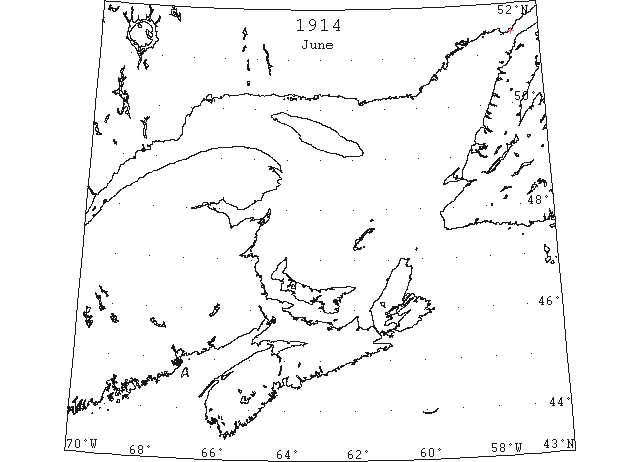
Jun 27 First Westbound steamer through the strait of Belle Isle. (WBB)