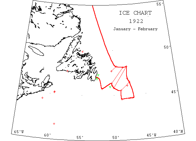
January/February

Jan 24 4810’N 4930’W to 4740’N 5020’W passed through fields and bands of ice; also Jan 28, 4515’N to 4511’N 5920’W passed through bands of field ice.
Jan 28 4650’N 4750’W encountered fields of ice and steamed through it 12m.
Jan 29 4738’N 573’W passed through heavy ice fields extending ~50m N and S; Feb 1, 4425’N 6107’W passed through heavy ice fields extending ~65m NE and SW.
Feb 3 St. John’s: The harbour blocked by ice for several days now, is cleared a 6 steamers previously unable to get in arrived.
Feb 3 SS “Weehawken” 4142’N 5859’W ice, sustained bow damage. (JH).
Feb 13 SS “Prospero” caught in the ice in Notre Dame Bay during a storm several weeks ago is still fast in the floe. Some of the crew walked the 20m to shore.
Feb 16 SS “Sisto” 19 days from Cardiff for St. John’s caught in heavy ice off St. John’s with her bows damaged. Feb 19, Mail SS “Kyle” forced her way through the ice and got in today to St. John’s from Louisburg.
Feb 18 “Seneca” 455’N 5150’W field ice; Feb 20, searched edge of Grand Banks to 45N 47W and found no field ice.
Feb 19 4715’N 5229’W, 2 bergs; 4650’N 5241’W a berg.
Feb 24&25 “Seneca” no ice observed or reported. Position 4355’N 5413’W.
Feb 27 St. John’s: SS “Sisto” still stuck. Ice in this harbour is heavier than for many years. SS “Bornholm” which arrived here yesterday was unable to force her way through and unloaded part of her cargo by sleigh. (“Sisto” arrived St. John’s Mar 8.)
Feb 27 2 bergs south of Cape Race 4555’N 5035’W.
Feb 28 4443’N 4655’W to 4432’N 4846’W saw field ice.
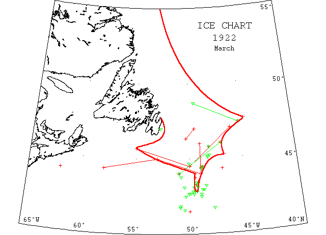
March

Mar 1 St. John’s: Ice floes now extend from the Newfoundland coast southward virtually to Halifax and eastward over the Grand Banks.
Mar 1-5 4420’N 47W saw a large field of ice ~45 to 50m long and 3/4 to 1m wide, extending in WSW to SW direction; 4th, 4342’N 5906’W saw a small patch of field ice ~3/4m long and 600′ wide; 5th, 4410’N 62W encountered patches of soft field ice.
Mar ~1 4659’N 5244’W a berg and field ice 6m off Cape Spear, 11m off Bay of Bulls and from 47N 4930’W to 4620’N 5020’W.
Mar 2 SS “Grantoft” in sinking condition with lifeboats smashed in 4748’N 4124’W. Ship which went to help found no trace. (No mention of ice).
Mar 6 Halifax: The Red Cross liner “Rosalind” which has arrived here from St. John’s reports that she had only 60m of open water out of 540m covered on the trip. She had to run south nearly as far as Sable Island to get round the heavy ice floes. Most of the trip she was steaming through ice.
Mar 6 SS “Bornholm” 5 days out of St. John’s for Halifax is stuck fast in slob ice 70m SW of Cape Race. Other ships unable to get close to her.
Mar 7 “Seneca”: Field ice may be met within following: 47N 46W to 4430’N 50W to 4540’N 55W thence to Cape Canso. 2 bergs 4512’N 4808’W; southern limit ice field 4420’N 49W.
Mar 8 4515’N 4645’W large field of ice; 44N 49W ice fields.
Mar 8 44N 4930’W saw field ice.
Mar 8 4345’N 4931’W sighted sludge ice.
Mar 9 Between 46N 47W and 44N 51W an ice field and 2 bergs; 4505’N 4819’W, 3 growlers.
Mar 10 SS “Oscar” 44N 4856’W passed through field ice.
Mar 10 St.John’s sealing fleet of 9 steamers sailed.
Mar 11 “Seneca” reports field ice may be met with 46N to 44N 49W to 45N 53W to 4420’N 58W to Cape Canso; 4510’N 4820’W, 2 bergs and growlers.
Mar 14 4256’N 4844’W berg sighted.
Mar 16 SS “Diana” caught in the ice and squeezed, held for 10 days. Abandoned, crew picked up by the SS “Sagona” and landed at Bay de Verde. (NW).
Mar 17 “Seneca”: 4311’N 4833’W a growler.
Mar 18 Sealer SS “Diana” tail shaft broken 10m E of Cabot Island (St. John’s reports); burnt at sea ~ Mar 8.
Mar 18-19 44-2’N 4855’W saw double peaked berg ~400′ high and 4426’N 4857’W encountered an extensive and impassable field of ice; 19th, from 44N 4856’W to 4316’N 4929’W saw an extensive field of ice containing growlers; also a berg about midway between and to the southwestward of the two last named positions.
Mar 18-19 “Seneca”: 4324’N 4925’W, 2 bergs; 4546’N 4808’W bergs and field ice; 4428’N 4850’W berg and field ice; 4256’N 4854’W berg; 4305’N 4940’W growler, and southernmost verified position of ice. 19th, 4324’N 4915’W berg and field ice; 4250’N 4924’W bergs and field ice; 4238’N 49W growler; 4439’N 5007’W berg. Mar 19 SS “West Quechee” at Boston from Liverpool was delayed on account of poor quality of fuel oil and obliged to burn cattle fittings; on Monday last, while trying to clear ice fields, a radio message was picked up from SS “Indier” from Antwerp for Philadelphia whose captain reported he was fast in the ice and could make no progress (arrived 21st.).
Mar 20 4250’N 4924’W encountered a field of ice of considerable extent and in which and some distance to the northward 3 bergs ~80′ high were seen. This position was apparently the southeasterly corner of the field which extended in a westerly direction for ~8m. From the southwestern corner of the field a narrow strip of small ice extended in a southwesterly direction for ~4m and beyond which in 4239’N 5007’W a double peaked berg was seen.
Mar 20 4304’N 4918’W passed close to 2 large bergs marking the southern end of broken ice field extending as far as could be seen.
Mar 21 “Seneca”: 4237’N 4942 berg; between 4840’N 4930’W and 472-‘N 4510’W bergs, growlers and field ice.
Mar 23 “Seneca”: 4250’N 4935’W berg.
Mar 24 “Seneca”: 4247’N 4945’W berg (same as yesterday).
Mar 25 “Seneca”: 4240’N 50W berg (same as yesterday).
Mar 26 “Seneca”: 4304’N 5031’W berg (same as yesterday); 4345’N 5051’W berg; 4135’N 5032’W berg.
Mar 27 SS “Diana” (neé “Hector”) became jammed in ice at the Front and lost her tail shaft. Abandoned and sank while burning. (SR).
Mar 27 4130’N 5005’W.
Mar 28 4142’N 4751’W berg 50′ long & 15′ high.
Mar 29 “Seneca”: 4145’N 5055’W southernmost berg; 4151’N 5053’W large berg; 4228’N 49W growler.
Mar 30 4228’N 5026’W berg.
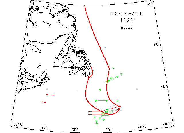
April

Apr 2 SS “Lord Ormonde” 4228’N 5002’W passed a large berg ~250′ long and 50′ high; also several growlers extending ~10m to the northwestward.
Apr 3 “Seneca”: heavy ice fields extend north from 4355’N 4940’W; large berg 4238’N 5002’W; dangerous for vessels to pass south of 42N between 40N and 51W; no ice reported west of 40N, south of 42W.
Apr 3 “Tampa”: Southern limit of ice field 43N 4910’W; position of southernmost berg 4228’N 5021’W.
Apr 5 SS “Thetis”, sealer, put into St. John’s with 16,000 pelts and bows badly battered by ice. Other ships moderately successful.
Apr 5 4730’N 4845’W several bergs in vicinity; 4139’N 5117’W small berg; 4146’N 5203’W berg.
Apr 5 SS “Minnekahda” 4118’N 5148’W a berg.
Apr 5 SS “Old North State” 4125’N 5145’W passed a berg ~150′ long and 60′ high [same as above ?].
Apr 7 SS “Canadian Carrier” 4316’N 6005’W to 4320’N 6035’W saw scattered and closely packed field ice extending north and east.
Apr 9 SS “Homeric” 4345’N 5011’W passed a growler.
Apr 10 SS “Estonia” 4414’N 5845’W to 4414’N 5950’W passed a large ice field.
Apr 10 4225’N 5011’W growlers; 4345’N 5155’W, 2 bergs; growlers between 5009’W and 5155’W in 4345’N.
Apr 11 Steam trawler “Raymond Or” encountered heavy ice extending southward to within 15m of Sable Island.
Apr 11 Cape Race, heavy open ice distant; Point Amour, heavy close packed ice moving west.
Apr 11 “Tampa”: drifting near berg 4220’N 4937’W; another small berg and 3 growlers scattered in vicinity 4215’N 5030’W.
Apr 13 Many small bergs and growlers observed around and south of the Tail of the Grand Banks.
Apr 15 4202’N 5042’W a small low berg.
Apr 16 “Tampa”: drifting near same berg 4230’N 4917’W; 4202’N 5042’W small berg.
Apr 17 5 growlers scattered along 42N between 50W and 51W.
Apr 17 Issue: SS “Sachem” reported stretches of field ice interspersed with growler and small bergs off Newfoundland coast; ice extended a distance of 150m south of Cape Race and steamer had to make long detour to southward to get clear.
Apr 17 4335’N 4820’W large berg.
Apr 19 4219’N 5046’W,1 small growler.
Apr 21 4556’N 5001’W numerous bergs and growlers.
Apr 22 Ice within following boundary line- southward on 48W to 43N, thence to 4230’N 51W, thence 4230’N 53W thence northward 53W.
Apr 23 4647’N 4725’W, 2 bergs and 1 growler; 4502’N 5108’W, 5 bergs and many growlers; between 4630’N 4809’W and 4557’N 4954’W, 10 bergs.
Apr 25 “Seneca”: reports ice area as follows – 4210’N 49W to 4210’N 53W then northward on 53W.
Apr 26 4102’N 5147’W, 4 bergs; southern limits of ice 43N 48W to 4210’N 49W to 4210’N 53W.
Apr 29 4718’N 5224’W small berg; 4602’N 4940’W growler; 4620’N 4915’W, 2 bergs; 4605’N 4945’W, 3 bergs.
May 2 SS “Erholm” 4608’N 5937’W held in heavy ice and heavy ice fields as far as could be seen.
May 2-3 SS “Canadian Volunteer” 4535’N 5825’W to 4520’N 5825’W open field ice; thence to May 3, 4620’N 5852’W, occasional field ice and through open field and slob ice to 4655’N 5855’W.
May 3 SS “Nervier” jammed in ice in Cabot Strait drifting oceanward.
May 3 SS “Montcalm” from 4646’N 6005’W to 4620’N 5947’W heavy close packed field ice; 4608’N 5937’W observed heavy fields of close packed ice as far as could be seen.
May 3 Point Amour, heavy close packed ice distant, 3m.; Belle Isle, heavy open ice everywhere; numerous bergs and growlers.
May 4 SS “Seneca” (Br) disabled in heavy pack in 4541’N 6045’W.