January/February
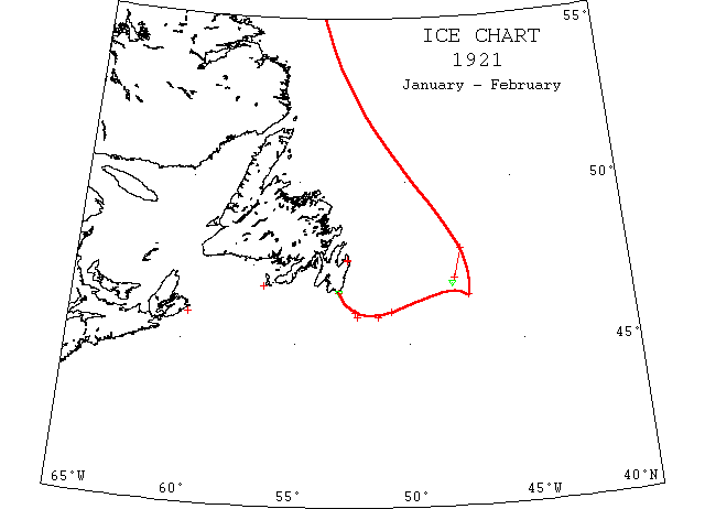
Jan 12 SS “Thorsberg” from Helsingor to Hampton Roads passed icefield approaching Cape Spear form northerly track. (#564).
Feb 12 Tern schooner “Marion Grace” wrecked at Miquelon in storm having been delayed 10 days at St. Pierre by ice fields, from Newfoundland to Halifax.
Feb 17 SS “Prospero” docked at St. John’s extensively damaged by ice.
Feb 21 Issue: SS “Delco” from Gothenburg via St. John’s for New York was caught in the ice off Louisburg for ~1 week.
Feb 22 St. John’s: SS “Kyle” held in harbour by ice pack which completely blocks it
Feb 22 Cape Race: slob ice was in sight everywhere.
Feb 24 4629’N 4719’W slob ice; 46N 5045’W to 4551’N 5121’W an ice field.
Feb 24 4755’N 4735’W encountered heavy sludge and field ice ~3′ or 4′ thick; cleared it 47N 4755’W.
Feb 24 4650’N 48W a small berg ~20′ high.
Feb 26 SS “Princess Matioka” at Boston from Naples struck berg or submerged wreck off Cape Race.
Feb 28 4559’N 5223’W sludge ice in rifts extending north and east.
Feb 28 4550’N 5217’W field ice & sludge extending continuous along edge of Bank.
March
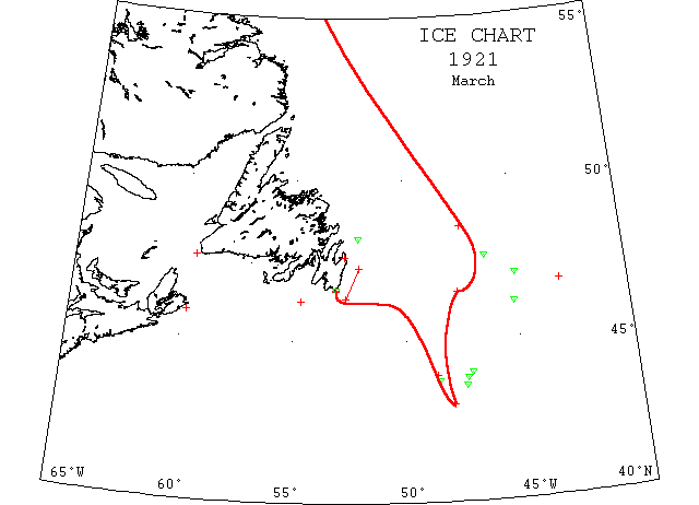
Mar 1 SS “Roald Jarl” at St. John’s damaged by ice, from Philadelphia for St. John’s
Mar 4 Schooner “Tipperaray” crushed in ice off Cape Race.
Mar 5 Halifax: North Atlantic ice floes which yesterday crushed 2 vessels off the Newfoundland coast, today were reported by Captain Mitchell of SS “Rosalind”, the worst he ever had experienced. He said that on his way here from St. John’s, after once having been forced to put back, he ran into heavy slob ice off Cape Race and sighted many growlers.
Mar 6 4613’N 5440’W and alongside NW edge of Grand Banks to 4716’N 5206’W field ice; 4810’N 5206’W, 2 bergs.
Mar 7 4735’N 4620’W a large growler.
Mar 8 4630’N 4740’W steamed through field ice.
Mar 10 Because of heavy ice off the Newfoundland coast steamship service between Boston and St. John’s has been suspended.
Mar 10 Schooner “Barbara” forced over a reef at Cape Race by ice and leaking. Schooner “Retraction” is caught in the same floe ~2m away.
Mar 11 SS “Turret Cape” at Louisburg damaged by ice.
Mar 15 4640’N 43W field ice.
Mar 15 SS “Rhode Island” encountered field ice 4830’N 4725’W and had to steer south to clear it.
Mar 19 SS “Bergensfjord” a large berg off the Flemish Cap.
Mar 19 4355’N 4840’W steamed through thick field ice.
Mar 19 Schooner “Roberta Ray” 43N 48W run into heavy field ice and crushed; abandoned and fired.
Mar 19 4350’N 4723’W a large berg ~300′ long and 120′ high; 4335’N 4727’W a berg ~100′ long and 50′ high.
Mar 20 4607’N 4509’W a large berg.
Mar 21 4345’N 4835’W a medium sized berg.
Mar 21 SS “Hollandia” 3750’N 4723’W a berg. (JH).
Mar 22 Cape Ray: Heavy close packed ice, distant, moving south; E. Scatari: everywhere.
Mar 25 4358’N 4711’W a berg ~400′ long & 80′ high; some growlers near it.
Mar 28 St. John’s: The Newfoundland sealing fleet which for many days has been in the grip of the coastal ice pack, at last has freed itself and located the seal herds. Mar 31 A small iceberg off Cape Race.
April
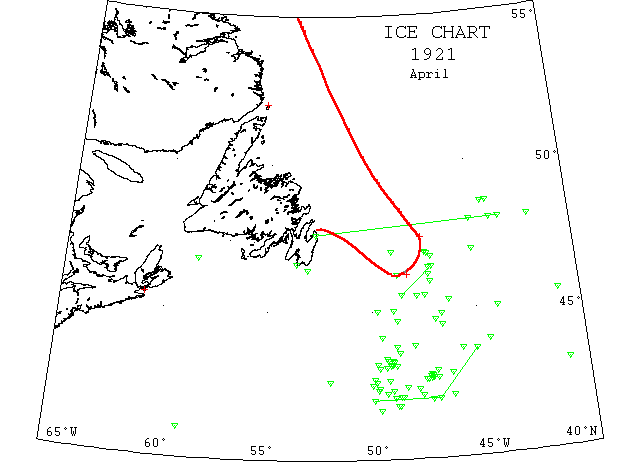
Apr 4 St. John’s: The first of the sealers to return “Diana” has bows damaged by ice which held the sealing fleet for several days.
Apr 4 Schooner “Gladys N. Hallet” damaged by ice between Burin and Martinique.
Apr 4 SS “Hollandia” 4335’N 3557’W a large berg. (JH).
Apr 9 SS “Castle Point” 4814’N 4713’W enmeshed in ice, short of fuel and propeller damaged.
Apr 9 “Seneca”: 4615’N 4815’W extending northward, field ice, limits undetermined; vessels on westbound tracks should observe extreme caution.
Apr 9 4207’N 4620’W a small berg; 4244’N 47W, 2 large bergs; 4257’N 4703’W a medium sized berg; 4240’N 4735’W a small berg; 4252’N 4630’W a berg; 4243’N 4713’W a berg; 4248’N 4716’W a berg; 4251’N 4719’W a growler; 4241’N 4728’W a berg.
Apr 10 Hydrographic Office: Many bergs have been reported within the following limits: 42N from 50W to 47W, thence through 4338’N 4509’W; many bergs within these limits and the Banks.
Apr 10 “Seneca”: Standing for 4814’N 4713’W where SS “Castle Point” short of fuel and propeller damaged. Bergs drifting rapidly toward lanes. SS’s “Sutherland”, “Victorian” and “Corsican” report bergs 4219’N 4907’W; 4205’N 4841’W and 4205’N 4901’W. Apr 10 4242’N 4721’W a berg ~60′ high; 4246’N 4722’W a berg ~75′ high; 42ΨN 4719’W a berg ~140′ high; 4148’N 4850’W bergs and several small growlers.
Apr ~10 SS “La Bourdonnais” between 4442’N 47W and 4428’N 4810’W bergs and growlers.
Apr 10-11 Icebergs sighted by “Seneca” and SS “Genesee”: 4656’N 4717’W; 4614’N 4714’W; 4659’N 4723’W; 4649’N 4705’W; 4627’N 4713’W; 46N 4710’W; 4531’N 4727’W; 4531’N 4749’W; 4528’N 4720’W; also field ice extending 20m E of 100 fathom curve above 45N, 30m wide, was traversed in 4730’N.
Apr 11 Cape Race: 1 berg in sight 10m S.
Apr 11 41N 59[!]W a berg 200′ long and 50′ high.
Apr 12 4355’N 4430’W a large berg.
Apr 13 “Seneca”: Icefields reported yesterday traced south to 44N, limits undetermined. Bergs reported this day: 1 large and 2 small bergs in 4209’N 4745’W; large bergs and growlers in 4206’N 4344’N; 4138’N 4941’W southernmost and westernmost berg.
Apr 14 4148’N 4855’W berg.
Apr 15 4148’N 4855’W a growler; 4453’N 4640’W a berg.
Apr 19 “Seneca”: 4225’N 4827’W a berg; several bergs and growlers along line from 4630’N 4704’W to 4532’N 4835’W.
Apr 20 4440’N 4850’W small growlers and medium sized berg 50′ high.
Apr 21 4835’N 4408’W a small berg and a heavy ice field extending ~10m to the westward.
Apr 22 IP cutter “Yamacraw”: Bergs in 4320’N 4920’W; 4323’N 4922’W; 4348’N 4852’W; 4335’N 4845’W; 4350’N 48W; 4520’N 4618’W; 4309’N 4910’W; 4317’N 4902’W; 4308’N 4855’W; 4309’N 4912’W large growler; 4312’N 4947’W berg aground on bank.
Apr 22 SS “Sachem” from Liverpool to Boston passed ~25 bergs east of Newfoundland in 38[!]N 4332’W until reaching St.John’s.
Apr 22 4340’N 4548’W a berg.
Apr 25 “Yamacraw”: bergs: 4220’N 4946’W; 4238’N 4917’W; 4305’N 4943’W.
Apr 26 SS “Waalhaven” at Halifax with propeller damage having been caught in ice fields off Cape Breton.
Apr 26 4320’N 4904’W, 2 bergs; 4310’N 4906’W, 2 bergs.
Apr 27 Bergs: 4222’N 4756’W; 4259’N 40[!]53’W; 4242’N 4957’W; 4306’N 4922’W; 4238’N 5162[!]’W; 4643’N 5832’W.
Apr 27 Point Amour, heavy close packed ice everywhere, moving SE; Cape Race, berg ENE 9m; Belle Isle, light close packed ice distant.
Apr 27 4613’N 4845’W a number of bergs and growlers.
Apr 28 Numerous bergs and growlers reported in following area- along 48N to 45W, then S to 47N, then W to 49W, the S to 45N, then E to 44W, then N to 48N.
Apr 29 Observed small bergs 4406’N 4934’W drifting southwest. Numerous bergs reported between 4430’N 4640’W and 45N 4945’W.
Apr 29 4223’N 4945’W a berg; 4230’N 5002’W a large berg; 4235’N 4953’W, 3 bergs aground.
Apr 29 4758’N 4203’W growler ~30′ long and 10′ high.
Apr 30 4212’N 4924’W bergs.
Apr 30 4520’N 41W a berg ~30′ high.
May 2 4148’N 4825’W a large berg.
May 2 4610’N 4505’W bergs and growlers.
May 3 4201’N 4942’W and 44N 5005’W bergs.
May 3 4433’N 4645’W a berg; 4429’N 4655’W large bergs.
May 4 SS “Gyp” from Halifax for Aberdeen reports by wireless via Cape Race that her bow plates have been dented by ice.
May 4 Bergs: 4203’N 5113’W; 4212’N 4926’W; 4230’N 5025’W; 4222’N 5035’W; 4134’N 4725’W; 4143’N 4906’W; 4146’N 4841’W; 4123’N 5128’W; 4151’N 4858’W; 4131’N 5123’W; 5 bergs within 5m radius of 4207’N 4843’W; bergs and growlers and pack ice 20m each side of track between 4630’N 46W and 4530’N 4950’W; bergs and growlers between 40N 4524’W and 4430’N 5839’W.
May 7 4020’N 4724’W growlers and packed field ice.
May 10 SS “Carmania” at Halifax from Liverpool passed through a heavy field of ice south of Cape Race. Many large bergs were sighted [edge bank and approximately 47N] and the vessel was held up by fog and ice for 8 hours.
May 11 SS “Lexington” at Boston from Glasgow passed a large number of bergs and growlers from 4737’N 49W and extended to a point 80m NE of that position; great stretches of field ice extended as far as the eye could reach, and for nearly 2 days the steamer was in ice fields interspersed with growlers and huge bergs; between 250 and 300 bergs were sighted; 1 large berg seen 7m NE of Cape Race, has been there since last June, which Capt. Ledsome reports has melted about half its original size.