January/February
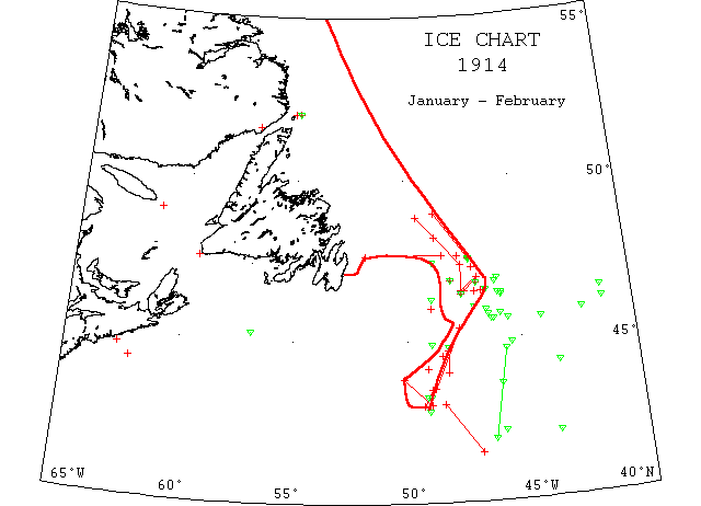
Jan 30 SS “Czar” from Libau 4812’N 4840’W encountered a big field of ice, berg dangerous to navigation; was obliged to steer 30m out of her course to the SE to find clear water.
Feb — SS “Lackawanna” from Manchester 4514’N 5655’W passed 2 bergs.
Feb 3 SS “Conrad Mohr” 4554’N 4628’W passed a small berg.
Feb 3 SS “Teutonic” 4646’N 4653’W a large berg; 4624’N 4733’W a large berg; also field ice and numerous growlers between the above positions.
Feb 4 Issue: SS “Megantic” from Liverpool reports that she has received by wireless from steamers: 46[?]N 47W, 2 bergs; 4615’N 4854 a berg 25′ high and 100′ long; 4650’N 48W, 1 large and 3 small bergs and field ice; 4646’N 4653’W, 1 large berg, field ice and numerous growlers. In one area of ice from 40 to 250m E of St. John’s was a berg 150′ high and 1/4m long.
Feb 4 Issue: SS “Cornishman” from Liverpool to Portland reports by wireless, 4630’N 4724’W passed a large field of drift ice and several bergs.
Feb 4 SS “California” 4630’N 4640’W passed S of large ice fields and through lines of pieces, some of which were large and dangerous [cf Feb 8].
Feb 5 Curling: U.S. naval tug “Potomac” failed to free the ice bound fishing schooners “Hiram Lowell” and “Frances Willard” in the Bay of Islands today. The tug narrowly escaped being caught in the ice which was driven in heavily from the Gulf of St. Lawrence before a NW gale.
Feb 5 SS “Deutschland” 4631’N 4629’W passed a berg.
Feb 6 SS “Sachem” from Liverpool to Boston 4546’N 4623’W passed several bergs.
Feb 6 SS “Cornishman” 4655’N 4650’W to 4630’N 4724’W passed large fields of drift ice and several bergs.
Feb 6 SS “Lord Antrim” from Narvik to Philadelphia 4850’N 4930’W encountered very solid and thick field ice and had to alter course to E and S, skirting the edge of the field to 4719’N 4732’W, thence due S to 4629’N 4732’W when ice was cleared. The above ice was in an immense continuous field, with spurs stretching even to the eastward of the above positions and extended possibly 50m westward.
Feb 7 SS “Mongolian”, 200m E of St. John’s, saw slob ice; 4725’N 4850’W a large berg.
Feb 8 SS “Caledonia” 4646’N 4603’W saw a large berg; 4630’N 4640’W field ice; 4547’N 4553’W a large growler; 4646’N 4653’W open field ice, numerous growlers and a large berg.
Feb 8 SS “Shenandoah” 4621’N 4547’W passed 8 of an iceberg.
Feb 8 SS “Grampian” 4538’N 4616’W passed a growler and a berg.
Feb 8 SS “California” 4630’N 4658’W passed S of a large field of ice; 4631’N 4629’W a berg ~700′ long and 40′ high.
Feb 8 SS “Kanawha” 4559’N 4855’W passed small pieces of ice.
Feb 9 SS “Texas” 4546’N 4623’W passed a large berg and from 4655’N 4650’W to 4630’N 4734’W saw field ice.
Feb 10 SS “Pretorian” 4337’N 4559’W large growlers reported; 4625’N 4547’W and 4538’N 4616’W large growlers.
Feb 12 SS “Columbia” from Glasgow 4536’N 4406’W passed a small berg.
Feb 12 SS “Grampian” 4538’N 4610’W saw a berg and a growler.
Feb 12 SS “Willesden” 4855’N 4839’W ran into a large body of field ice; altered course to S and E and continued to pass large quantities of ice until 14th, 4730’N 4710’W, numerous small bergs were sighted in the ice; a large berg ~100′ high and 250′ long was sighted 13th in 4728’N 4710’W.
Feb 13 Canadian Signal Service reports: L’Islet, heavy close packed ice everywhere; Riviere du Loun, heavy open ice; Father Point, heavy close packed ice everywhere; Matane, ice packed everywhere; Fame Point, heavy close packed ice everywhere; Flat Point, light open ice everywhere; Seven Is., bay still solid; Point Amour, heavy close packed ice distant.
Feb 13 SS “Zijldyk” 4544’N 4216’W passed a large berg.
Feb 14 SS “Helios” from Rotterdam 46N 4120’W passed a small iceberg.
Feb 15 SS “Nieuw Amsterdam” 4210’N 4559’W passed a small berg, surrounded by a small quantity of field ice.
Feb 16 US Navy tug “Potemac” previously held fast in the Bay of Islands was abandoned.
Feb 16 Canadian Signal Service stations report: Rivier du Loup, heavy open ice; Father Point, heavy close packed ice everywhere, stationary; Fame Point, heavy open ice; Heath Point, heavy close packed ice everywhere; Flat Point, heavy close packed ice inshore; Belle Isle, heavy close packed ice everywhere, 4 bergs.
Feb 17 SS “Carthaginian” 4621’N 4120’W ice was sighted.
Feb 19 SS “Belfast” 4715’N 4701’W encountered a large quantity of field ice and a number of growlers.
Feb 19 SS “Athenian” 4655’N 4650’W field ice; 4630’N 4724’W field ice; 4537’N 4533’W growler and bergs; 4625’N 4557’W a berg; 4538’N 4616’W a berg.
Feb 20 SS “Iona” 4452’N 4855’W passed a small berg.
Feb 21 SS “Lackawanna” 4514’N 5655’W passed 2 bergs ~150′ in diameter. Feb 22 Canadian Signal Service Stations report: Matane, ice making fast; Point Amour, heavy close packed ice distant, moving east; Belle Isle, heavy close packed ice everywhere, 3 bergs.
Feb 22 SS “Athenia” 4452’N 4526’W passed a large berg; 4447’N 4815’W encountered field ice and proceeded south 60m to clear the same.
Feb 22 SS “Malvern Range” 4408’N 4909’W fell in with field ice at noon and must have struck the centre of the pan, as we were steering W by N and had to haul ship to the southward until 6:30 pm; from 3 pm to 4:30 pm we were steering SE and after that gradually bringing the vessel back to her course; after 6:30 pm we passed through small patches of pan ice and then saw no more.
Feb 23 SS “Cassandra” radioed that it was reported that in 4440’N 4815’W field ice had been met with, which necessitated proceeding 40m to the southward to clear it.
Feb 24? SS “Minia” passed 50m of Gulf field ice off Bank Queno. Off Louisburg the ice has imprisoned a large fleet of steamers and sailing vessels.
Feb 24 SS “Canada” 43N 4902’W passed through 10m of broken field ice. This position is 130m NW of the corner of 4130’N 47W and 90m northward of westbound tracks (approximately).
Feb 24 “Seneca”: ice field reported just north of one previously reported by SS “Canada”.
Feb 24 SS “La Savoie” between 4154’N 4623’W and 4440’N 4544’W sighted 3 bergs.
Feb 24 SS “Bergensfjord” 4416’N 6208’W for 4 hours passed through field ice; near Sable Is, some heavy pieces were sighted.
Feb 24 SS “Sloterdyk” from 4521’N 4743’W to 4330’N 4851’W saw much field ice in direction SSW, NNE; we were obliged to steer a southerly course, the ice being too thick to be crossed; saw a berg ~45′ high.
Feb 25 SS “Armenia” at Halifax from Hamburg sighted field ice 40m off shore.
Feb 26 SS “Ockenfels” at Philadelphia from Narvik 4653’N 4555’W passed 2 bergs, 1 was ~400′ long and 39′ high, the other was very small.
Feb 26 SS “Belfast” at Baltimore from Cardiff with some plates damaged by ice when off the Grand Banks.
Feb 27 Canadian Signal Service reports: L’Islet, river clear; Riviere du Loup, heavy open ice; Father Point, open ice inshore; Matane, light open ice; Fame Point, heavy close packed ice everywhere; West Point, very little ice; Heath Point, heavy close packed ice distant; Money Point, heavy close packed ice inshore; Magdalene Is., heavy close packed ice everywhere; Cape Ray, heavy close packed ice everywhere; Flat Point, heavy close packed ice everywhere, moving SE; Seven Is., bay still solid; Point des Monts, light open ice distant; Point Amour, heavy close packed ice distant moving W; Belle Isle, light open ice everywhere.
Feb 28 Cape Race: A small berg in 4315’N 4902’W; a large field of heavy ice just north of this; all moving south 10m a day; field ice melting rapidly; same day, a medium berg in 4249’N 4908’W in edge of Gulf Stream, moving ENE 6m a day.
Feb 28 “Seneca”: Ice fields 43 to 49.2. Found large field heavy ice extending N and W from 43 30 to 49. Recommended that all vessels cross 49 S of 43.
Feb 28 SS “Pretorian” 4202’N 4341’W passed a large berg.
Feb 28 4410’N 4327’W, 2 bergs were passed; 4315’N 4910’W another.
March
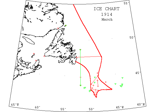
Mar 1 SS “Royal Edward” 4410’N 4327’W sighted 2 bergs [cf Feb 28].
Mar 1 SS “Principello” 43N 49W met thick field ice and proceeded 40m due S to clear it.
Mar 1 SS “Turcoman” 4240’N 4923’W skirted the edge of a large field of broken ice which extended northward as far as could be seen. Several detached pieces were also seen to the southward.
Mar 1-2 SS “Manchester Spinner” 4316’N 4939’W met broken field ice; 2nd, 4256’N 5006’W passed a berg ~400′ long and 90′ high; 4250’N 5013’W met another berg 300′ long and 100′ high.
Mar 2 SS “Turcoman” 4257’N 47W saw very thick field ice to the northward from this position until dark at 4259’N 46W.
Mar 4 SS “Caroline” 4338’N 4926’W saw field ice floating quite high out of the water.
Mar 4 SS “Chicago City” from Swansea 4458’N 4829’W sighted an ice field ahead, stopped the steamer and waited for weather to clear. 5 hours later, weather clear, ice extended north and south as far as could be seen. Proceeded S and saw last of ice in 4349’N 4950’W; 4444’N 4904’W saw a medium sized berg.
Mar 4 Canadian Signal Service Stations: L’Islet and Riviere du Loup, no ice; Father Point, light open ice; Matane, heavy open ice everywhere, moving W; Point Manquereau, heavy open ice; West point, heavy open ice inshore; Ellis Bay, no ice outside bay; Money Point, heavy open ice inshore; Magdalen Is., heavy close packed ice everywhere; Gross Isle, heavy close packed ice, moving W; Cape Traverse, heavy open ice distant; Cheticamp, ice off shore; Cape Ray, heavy open ice distant; Flat Point, heavy close packed ice everywhere, stationary; Point Amour, heavy close packed ice distant; Belle Isle, light close packed ice distant, 2 bergs.
Mar 5 SS “Cayo Domingo” 4401’N 4910’W passed a small berg and 4 growlers; also a large piece of ice ~10′ high and 150′ long. The night was dark but have every reason to believe that there was a large quantity of ice in the vicinity; 6th, 4321’N 5102’W saw a large berg 8m N 5W with a high pinnacle on each end; 4318’N 5114’W a large berg 2m N 5W, 80′ high and 243′ long, with a number of growlers around it. Mar 6 SS “Riverdale” at St. John’s reported ice fields extending 200m off the Newfoundland coast. It is seldom that field ice has been found so far off shore this early in the season.
Mar 10-Apr 2 SS “Newfoundland” disaster. 10th, left St. John’s for Wesleyville to pick up more sealers; 30th, in the vicinity of the Funks Is.; 31st, men left for SS “Stephano” about 4 hours away over rough ice, and then to hunt a small patch of seals. Storm got up. When over 2 days later, 77 men were dead. Survivors picked up by SS “Bellaventure”, “Florizel” and “Stephano”. (NW).
Mar 13 Canadian Signal Service reports; Cape Ray, no ice; Scatari, heavy close packed ice everywhere; Point Amour, heavy close packed ice distant, moving west. [ for other locations, see NYMR].
Mar 14 SS “Batsford” at Halifax from Sunderland via Louisburg had hull and propeller damage off Halifax.
Mar 14 SS “Ascania” 4220’N 4923’W and in 42N 49W field ice was sighted.
Mar 15 “Seneca”: saw no ice between 42N and 43N and 49W and 51W.
Mar 16 “Seneca”: Scouted between Bank and Gulf north to 4330’N. Ice field previously reported near 43N 49W melted, except few scattering pieces; not dangerous; saw no berg. Noon; found disconnected patches loose slob ice extending from 4340’N 4835’W, northward about 15m; no bergs seen or reported.
Mar 17 SS “Bohemian” 4255’N 4835’W slob ice was sighted.
Mar 18 “Seneca”: no new reports, ice melting fast.
Mar 19 SS “Digby” 4520’N 4832’W field ice.
Mar 20 SS “Ballanca” near 43N between 49W and 50W patches of field ice.
Mar 21 “Seneca”: field ice with 2 bergs in it, extends from 4340’N to 4840’N about 30m in stretch.
Mar 22 SS “Magdalene” passed through an ice field on the southern edge of the banks and received a heavy pounding loosening plates and leaking.
Mar 22 “Seneca”: Many growlers, widely scattered north of 43N, between Grand Banks and Gulf Stream; vessels should avoid this stretch, except in daylight and clear weather.
Mar 23 SS “Jacona” 44N 47W encountered loose field ice and passed along the edge of it for 6 hours; several small bergs and growlers were in the ice.
Mar 25 SS “Empress of Ireland” 4322’N 4356’W a large berg.
Mar 26? SS “Ruthenia” 4423’N 4343’W saw a very large berg.
Mar 30 SS “Ionian” 4330’N 4354’W and 4337’N 4512’W saw a berg.
Mar 31 SS “Cymric” 4317’N 4416’W a berg; 4313’N 4405’W, 2 growlers.
April
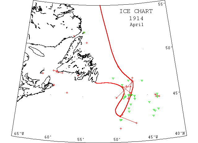
Apr (late) SS “Stanley” reports: loose ice extends 6m off E side of St. Paul’s Is. No ice between this and Cape Ray. Light scattered ice extends from St. Paul’s Is. toward the NW, which is the end of the Gulf Pack.
Apr (probably late) SS “Pomeranian” 4816’N 4920’W an ice field, no passage to westward; recommend going well south to clear ice fields; passed through ~10m of fairly heavy field ice when ~20m NW of Cape Ray.
Apr (probably late) SS “Athenia” reports: along 4506’N saw a growler in 4726’W, 2 growlers close to in 4732’W, a growler in 4738’W; passed through ½m strip of field ice, running NNE and SSW, in 4750’W; saw 6 bergs, 3 to the northward and 3 to the southward in 4754’W. From Cape Ray to 25m westward passed through open field ice.
Apr 2 Curling,NF: Sealing SS “Newfoundland” reported lost off Cape Race and the greater part of the 170 men perished.
Apr 3 St. John’s: Sealer “Southern Cross” bound for this port feared lost with 173 men. Passed by SS “Portia” Mar 31st, 6m SW of Cape Pine.
Apr 3 Canadian Signal Service: Scatari, heavy close packed ice everywhere; Pint Amour, heavy close packed ice distant, light open ice inshore moving west [for other locations see NYMR].
Apr 5 SS “Saturnia” 4411’N 4449’W a berg.
Apr 5 Revenue cutter “Seneca” no ice on the Tail of the Banks.
Apr 5 Schooner “Saint Solen” from Saint Malo to Newfoundland struck by ice in the North Atlantic. (PR).
Apr 7 “Seneca”: Cruised between Banks and Gulf north to 4330’N; saw no ice. Berg reported in 4317’N 4416’W and 2 growlers 4311’N 4404’W.
Apr 7 Cape Race: Heavy close packed ice everywhere.
Apr 10 “Seneca”: Scouted north to 4425’N 4815’W, no ice seen or reported.
Apr 10 SS “Californie” 4130’N[or 4430′?] 4920’W passed through field ice in fog.
Apr 11 SS “Erodiade” 3255’N 6211’W apparently river ice about the size of a lifeboat. (JH).
Apr 11 Scatari: Heavy close packed ice everywhere.
Apr 12 “Seneca”: Found field ice extending northward from present position 4445’N 4341’W; several small growlers in it and 3 small bergs.
Apr 13 “Seneca”: 1 large and 7 small bergs just east of Grand Banks between 4440’N and 45N; field of loose slob ice just east of these bergs extending 20m NNE and SSW.
Apr 13 SS “Tyrolia” 4240’N 4423’W and 4321’N 4331’W several bergs were sighted.
Apr 14 Cape Ray: Heavy close packed ice everywhere, moving SE; Scatari; heavy open ice moving S; Point Amour; heavy close packed ice distant; Belle Isle, heavy close packed ice distant. Apr 15-16 “Jethou” 4634’N 4540’W passed among small bergs, 40 being seen before dark; 16th, 4642’N 4750’W, 2 large bergs were sighted and 47N 5015’W, 2 more large bergs.
Apr 19 “Miami”: 4318’N 4758’W a berg.
Apr 19 SS “Mongolian” 4404’N 4739’W and 4339’N 4758’W a growler.
Apr 20 SS “California” at New York from Bordeaux and St. Pierre encountered large fields of rotten ice between Flemish Cap and Grand Banks damaging bow plates & propeller.
Apr 20 Cape Ray: Light open ice stationary; Belle Isle, slob ice; Scatarie, heavy open ice distant.
Apr 21 Point Amour: Heavy close packed ice, distant, moving south; Bell Isle, slob ice, 3 bergs.
Apr 22 SS “Canada” 4606’N 4812’W ice field and bergs extend in every direction for miles.
Apr 23 “Miami”: Heavy field ice and bergs from 4606’N to 4520’N and from 4850’W to 4734’W; 4454’N 4835’W berg sighted. SS “Canada” steamed 52m along south edge.
Apr 23-25 “Touraine” 4511’N 4840’W passed an icefield; 25th, 4522’N 5730’W, 1 am saw field ice ~8m distant; from 2 pm to 2:40 pm another field of ice.
Apr 24 “Miami”: Heavy field ice in 46N extends from 4850’W to 4734’W. The field ice also contains many bergs.
Apr 25 “Miami”: 11 bergs, 1 growler between 4457’N and 4015’N [or is it 4615′] and 4825’W and 4850’W; heavy field ice extends from 46N and 4840’W to 4734’W; field ice contains many bergs.
Apr 25 SS “Montfort” from Antwerp to Montreal in Cabot Strait entered heavy field ice apparently blocking the strait and along the Newfoundland shore east of Cape Ray to a distance of 30m; 26th, cleared the ice; Cabot Strait was apparently clear as far as could be seen to the S and W, but an ice field extended as far as could be seen along the NW shore of Newfoundland.
Apr 26 “Miami”: Position 4451’N 4948’W; field ice extends to 4636’N 4705’W.
Apr 26 Point Amour, heavy close packed ice distant, moving west; Belle Isle, heavy close packed ice distant, 7 bergs.
Apr 27 St. John’s: SS “Bonaventure” will go into dry dock here to have 2 new blades put on her propeller, replacing those that were carried away in ice fields.
Apr 28 Halifax: SS “Nordkap”, rivets loosened in ice Harbour Breton to Louisburg.
Apr 28 SS “Rappahannock” 43N 49W loose pieces of ice.
Apr 29 “Miami”: Field ice, numerous bergs and growlers extend south 4250’N 4920’W. Have advised steamers to keep south of 42N as far as 47W.
Apr 29 St. John’s: SS “Tritonia” caught in blizzard and moving ice 10m NE of Shag Rocks, Notre Dame Bay, situation dangerous.
Apr 29 “Miami”: Field ice and bergs last reported have probably drifted south with northerly gales.
Apr 30 St. John’s: SS “Tellus” arrived from Rotterdam with forepeak and bow damaged and in need of new propeller, probably caused by ice.
Apr 30 SS “Cameronia” 4225’N 4920’W a berg and several growlers. Recommend all vessels cross 47 south of 42.
Apr 30 SS “Cameronia” 4226’N 4911’W passed a low lying dangerous berg and numerous pieces of ice to the northward.
Apr 30-May 1 SS “Megantic” 4658’N 4711’W saw enormous ice field studded with bergs; steered in a southerly direction, skirting it all day, stopping for the night in 4445’N 48W; cleared ice field daylight May 1; saw many bergs in 4445’N 4842’W, but none afterwards.
May — SS “Royal Edward” hit a berg east of Cape Race and received extensive damage to bows. (IIP59).
May 1 SS “Numidian” 45N 4717’W passed a small berg; 4451’N 4810’W a long low berg ~500′ long and 20′ or 25′ high. Between the above positions saw several small bergs and growlers.
May 2 “Seneca”: Found bergs in 4249’N 4854’W and 4224’N 4847’W, 2 growlers near latter.
May 2 SS “Winifredian” 4215’N 4843’W a berg, and growlers from there NE to 43N 48W.
May 3 SS “Czar” from Libau to Halifax 4145’N 4755’W, 4 small bergs.
May 4 SS “Cotswold Range” 4220’N 4820’W passed a medium sized berg and numerous small bergs drifting south.
May 4 Scatari, heavy close packed ice inshore; Cape Ray, loose strings distant; Point Amour, heavy close packed ice everywhere, moving west, 3 bergs; Belle Isle, heavy close packed ice distant, 3 bergs; C. Race, several small strings loose ice drifting SW.
May 5 “Seneca”: Searched between 4130’N and 42N and 4740’W and 4830’W, no ice; SS “Montrose” reports crossed from 50W to 47W on 42N and saw no ice; previous report of ice below 42N evidently erroneous; found berg and 3 growlers 5th, 4234’N 4815’W moving slowly north.
May 8 St.John’s: SS “Tritonia” before reported caught in the ice off Notre Dame Bay in danger of sinking with sides crushed and some compartments flooded; 20m NE of Fogo wireless station.
May 18 St.John’s: SS “Tritonia” arrived damaged by ice.
May 29 Wood schooner “Golfino” 4529’N 4820’W hit a berg and sank. (IIP59).
Jul 14 Mission ship “Harmony” encountered thick heavy ice about 100m from the coast of Labrador stretching as far as the eye could see. 6 days in the ice before reaching Makkovic Jul 20, propeller blade broken and passed berg ½m long. The ice was later this year than the captain had seen in 13 years he had been on the coast.(EW).