This updated article was originally published in the March 2014 edition of the Atlantic Daily Bulletin of the British Titanic Society.
Captain E.J. Smith of the R.M.S. Titanic:
His previous ice experience
by Brian T. Hill and Alan Ruffman
Introduction
In reading any account, or following any of the discussion forums on the Internet, of Captain Edward John Smith, master of the RMS Titanic and his fateful encounter with the iceberg on the night of 14 April 1912, it is not uncommon to be told that he had never seen ice this far south, or that this year was an exceptionally bad year for ice. Capt. Smith was following the established steamship track across the North Atlantic, one agreed upon by the steamship lines not only to avoid ice hazards, but to avoid oncoming traffic heading in the opposite direction. Yet despite the assertion that this was an unusually bad year for ice, we are also told by the British Board of Trade inquiry into the sinking of the Titanic that, owing to the presence of ice in 1903, 1904 and 1905, the steamship tracks had been temporarily moved further south than the then-accepted track. So, the question arises just how bad were the ice conditions of 1912? Surely, if the shipping lanes had been moved south in previous years, then ships’ officers of any experience would be knowledgeable of this. Were the ice conditions in the winter/spring of 1912 anything really unusual, or were they part of the accepted variability and had that year’s conditions been exaggerated, perhaps to help exonerate those involved in the tragedy that ensued?
Ice in the North Atlantic and on the Grand Banks
Ice in the North Atlantic, as in many other areas of the world, originates from two main sources, sea ice and icebergs. Most extensive is the sea ice formed by the freezing of seawater, which freezes at a nominal -2°C depending on the salt content of the water. Most of the sea ice to be found on the Grand Banks formed much further north in the Arctic waters of Baffin Bay and the sub-Arctic waters off the coast of Labrador, drifting south in the Labrador Current as the winter progressed. The southward drifting sea ice mixes with locally formed sea ice on the near shore waters of Newfoundland, typically starting in January and reaching a maximum extent in late March, by which time the sea ice could be up to a meter thick. The sea ice then starts to melt and recede to the coast of Labrador by about June of the year. The variation from year to year can be considerable, with sea ice in some years covering essentially the whole area of the Grand Banks and in other years barely reaching the northern coasts of Newfoundland. The amount of ice depends on such variables as air and sea temperatures, ocean currents and wind.
The other form of ice is icebergs, calved principally from the huge Greenland glaciers as they meet and flow into the sea. The icebergs eventually cross to the western side of Baffin Bay and drift southwards along the Labrador coast towards the Grand Banks, on a journey that can take anything from one to three years or so. Icebergs can be huge with areas covering many square kilometers and weighing billions of tonnes, and with drafts extending deep into the sea, their progress is largely dictated by the ocean currents rather than surface winds. How far they drift south depends on the strength of the Labrador Current and sea and air temperatures. They are protected to a large degree by the presence of sea ice, indicative in itself of cold sea surface temperatures, which subdues the ocean swell and reduces the erosion through wave action. The number of bergs drifting south of the 48th parallel of latitude and thus threatening the trans-Atlantic shipping lanes can also vary enormously from near zero in some years, to thousands in others. The peak number of bergs south of 48° N is normally reached in May or June, and unlike sea ice, icebergs can be found there in any month of the year although they are unlikely in the months October to January especially in more recent years.
Ice in any form is a threat to mariners. As early as 1855 Lieutenant Matthew F. Maury of the United States Navy advocated ideas to separate eastbound and westbound traffic from each other, and also to avoid the foggiest and most iceberg prone waters[1]. By 1889 at least, shipping lanes were being suggested in the North Atlantic Pilot charts of the U.S. government[2] but was not until 1891 that a mutual agreement was drawn up between several of the major shipping lines to adhere to specific lanes. Eventually an agreement was formalized by all the steamship companies in 1898 to instigate shipping lanes, routing ships to and from the major North American and European ports, and which could be adjusted as necessary as the ice season progressed[3]
Sources of ice and iceberg data in the North Atlantic
The authors have been documenting historical ice conditions off the Canadian east coast and the Grand Banks area for several decades now, and have compiled tens of thousands of ice reports[4]. Many sources have been gleaned for ice reports including contemporary newspapers and shipping gazettes or journals. The most significant of the sources was the finding of the weekly Hydrographic Bulletin (HB) of the U.S. Hydrographic Office published from 1889 until 1954, which was found at the U.S. National Archives and Records Administration[5]. This service and publication were in many ways precursors of the International Ice Patrol (IIP), which was formed after the sinking of the Titanic. It provided information on the hazards to navigation which include such things as ice and the presence of floating derelicts in the North Atlantic. These had long been a concern and had already provoked the need for some kind of early warning system which the IIP would eventually fulfill. All the ice records, photographed and transcribed by the present authors, are available in the public domain, the Excel files of iceberg sightings, one file for each year, being available at the web site[6]. Many of the records include the sighting source when known, which is mainly the name of the reporting ship, so it is possible to search the data on that basis. Thus if we know the names of Capt. Smith’s ships prior to 1912 it is possible to find if that ship had reported ice.
Ships Capt. Smith sailed on and their encounters with sea ice and icebergs
Capt. Smith first went to sea as a 17 year old boy in 1867. The following is a list of his ships adapted from Gary Cooper’s excellent book “Titanic Captain: the Life of Edward John Smith”[7] and a posting of his on the Encyclopedia Titanica website forum[8]; “A Captain’s Career”[9] was also used for comparison and minor additions. Corrections by ourselves are indicated in the footnotes. The name of the ship is shown in bold, followed by the name of the Captain when known, Smith’s rank on the voyage in brackets, abbreviated notes of the voyages, and ice reports, if any. Occasionally the name and rank of the officer actually submitting the ice report is given. Our comments are added in italics at the end of an entry or between entries.
1867 – 1868 Senator Weber (Boy) Hong Kong – S.Francisco – Chile
1868 – 1870 Senator Weber (3rd Mate) Japan – Antwerp
1870 – 1871 Amoy (AB) Norfolk, Virginia
1871 Madge Wildfire (AB) Canada – Newfoundland
1871 – 1872 Record (2nd Mate) New Orleans
1872 Agra (2nd Mate) ?
1872 – 1873 N. Mosher (2nd Mate) New Orleans
1873 – 1875 Arzilla (Mate, registered Liverpool) Bremerhaven – Canada – Peru
1876 – 1879 Lizzie Fennell (Captain) Callao and Atlantic run
1880 Lizzie Fennell (Captain) home run from Virginia
There is no record of any of the above ships encountering ice in the North Atlantic in these years. Capt. Smith joined the White Star Line in 1880, the SS Celtic being his first steamship
1880 March – December SS Celtic, Gleadell,(4th-3rd Officer) North Atlantic No ice reports.
1881 January – December Celtic (4th-3rd Officer) North Atlantic No ice reports.
1882 January – March Celtic (4th-3rd Officer) North Atlantic No ice reports.
March – December Coptic, Kidley, (2nd Officer) Pacific Service Hong Kong Japan No ice reports.
1883 January – December Coptic (2nd Officer) Pacific Service No ice reports.
1884 January – March Coptic (2nd Officer) Pacific Service No ice reports.
March – December Britannic, Perry, (2nd Officer) North Atlantic
6 March 42°16´N 48°03´W passed an iceberg about 70 feet high and 250 feet long; 42°06´N 50°´W passed 2 small bergs. Monthly Weather Review (MWR) Feb. p.39.
15 May 44°35´N 49°08´W passed 2 large bergs. MWR May p.119.
18 June 43°50´N 48°42´W passed several icebergs. Lloyd’s List (LL) Jul 4 p.6 c.18. New York Maritime Register (NYMR) Jun 25 p.3. MWR p.142 but reports the ice in 48°49´W.
For a total of 4 ice reports, the 2 small bergs on 6th March being a mere 27 miles to the NW of where the Titanic would eventually meet its fate[10], and this over a month earlier in the season.
1885 January – July Britannic, Perry,(2nd Officer) North Atlantic
17 February 45°30´N 45°10´W 3 bergs at 2 p.m. MWR Feb. p.35.
18 February 43°00´N 49°15´W at 5 a.m. passed one berg & a quantity of field ice; 42° 51´N 50°03´W at 9 a.m. passed 2 bergs; 42°37´N 50°45´W passed a berg. MWR Feb. p.35
25 March 44°07´N 48°50´W large berg; 44°07´N 49°05´W small berg; 44°47´N 48°50´W large berg. MWR Mar. p.62
26 March 42°48´N 54°02´W small berg. MWR Mar. p.62
22 April 45°03´N 47°30´W 2 large bergs; 44°44´N 48°40´W small berg. MWR Apr. p.89
20 May 44°58´N 49°08´W a berg. MWR May p.119
3 June from 42°25´N 51°27´W at 1 p.m. to 42°43´N 49°40´W at 7:40 p.m. passed 25 bergs of various sizes; 42°53´N 48°06´W at 9:25 p.m. a berg. MWR June p.146 and LL Jun 10 p.7 c.22 [which reports initial lat. at 1 p.m. as 42°45´N which is less likely].
4 June 43°02´N 47°52´W at 1:50 a.m. a berg. MWR p.146
17 June from 43°21´N 48°00´W at 9:54 a.m. to 42°50´N 49°03´W at 1:56 p.m. passed 13 icebergs and some detached ice. MWR June p.147
22 July at 3:45 p.m. 42°50´N 49°56´W a small iceberg; 42°45´N 50°16´N at 4.45 p.m. a large berg & several pieces. MWR July p.173
For a total of 17 ice reports comprising 57 icebergs of various sizes plus smaller pieces of ice and field ice.
July – December Republic, Irving, (1st Officer) North Atlantic No ice reports.
1886 January – December Republic (1st Officer) North Atlantic
23 March 44°20´N 49°02´W growlers. Capt. Irving. MWR Mar pp 66&67
One ice report.
1887 January – April Republic (1st Officer) North Atlantic
22 March 43°N 49°W to 43°30´N [likely 42°30´W] 50°W bergs; Capt. Irving. MWR Mar p.74
23 March 42°33´N 56°40´W bergs. MWR Mar p.74
Two ice reports comprising several bergs.
April – August Republic (Temporary Command) North Atlantic
25 May 43°27´N 48°53´W medium sized berg. MWR May p.133
On his first command he passes an iceberg in late May.
August – December Britannic (1st Officer) North Atlantic No ice reports
1888 January – February Britannic (1st Officer) North Atlantic No ice reports
April – May Baltic (Captain) North Atlantic No ice reports
June – September Britannic (Perhaps Acting Captain) North Atlantic No ice reports
December – Cufic (Captain) North Atlantic No ice reports
Captain Smith is now captain for the remainder of his voyages.
1889 16 January – 11 February Republic North Atlantic No ice reports
10 April – 26 August[11] Celtic North Atlantic No ice reports
23 October – 4 December – Adriatic [12] North Atlantic No ice reports
12 – 31 December – Coptic New Zealand route No ice reports
1890 1 January – 8 April Coptic[13] New Zealand route No ice reports
24 – 31 December – Adriatic North Atlantic No ice reports
1891 1 January – 16 March[14] Adriatic North Atlantic No ice reports
March – April[15]
27 May – 31 December Britannic North Atlantic
28 July 43°16´N 49°25´W E.J. Smith (RNR [Royal Naval Reserve]) large berg HB 101 Aug 5
One ice report
1892 January – December Britannic North Atlantic No ice reports
1893 January – May Britannic North Atlantic No ice reports
June – Adriatic North Atlantic No ice reports
12 July – December Britannic North Atlantic No ice reports
1894 January – December Britannic North Atlantic
No ice reports (but to help confuse the issue there is another SS Britannic out of Sunderland and another White Star Liner SS Cufic is commanded by an H. Smith)
1895 January – April Britannic North Atlantic No ice reports
May – June Germanic North Atlantic No ice reports
July – December Majestic (won race against St. Louis thus securing U.S. mail service for next 10 years) No ice reports
1896 January – December Majestic North Atlantic
27 April 42°45´N 48°27´W to 42°26´N 52°05´W 12 large bergs & growlers. HB 349 May
19 December 45°50´N 47°14´W large berg HB 385 13 Jan. 1897
Two ice reports.
1897 January – December Majestic North Atlantic No ice reports
1898 January – December Majestic North Atlantic
18 September 45°20´N 49°14´W large berg, Smith, 4th Off. Crossland. HB 476 Oct 12
One ice report.
1899 January – December Majestic North Atlantic
27 March, Smith, 4th Off. Crossland, position 42°04´N 51°54´W large berg 13 miles[1] S [= 41°51´N.] HB 501 Apr 5
24 April, Smith, 4th Off. Crossland small berg 41°48´N 50°17´W. HB 505 May 3
Two ice reports, the first on 27 March being just 5 nm to the north of Titanic’s collision latitude. The next, on the 24th April is almost exactly at the same latitude but 22 nm to the west, and a mere 6 miles from where the Titanic thought she was when her distress calls were sent out (41°46´N, 50°14´W).
1900 January – December Majestic December 1899 – April 1900 Boer War service then N. Atlantic No ice reports
1901 January – December Majestic North Atlantic No ice reports
1902 January – November Majestic North Atlantic No ice reports
December Germanic North Atlantic No ice reports
1903 1 January – 6 May Germanic North Atlantic
14 April, Smith, Officer Moxon, position 42°02´N 53°50´W saw large berg 6 miles S [= 41°56´N.] Liverpool to New York. HB 712 Apr 22
One ice report of a large berg almost at the same latitude as the Titanic collision (41°46´36´´ N), the distance between latitudes being less than 10 nm.
May – December Majestic North Atlantic
13 July, Smith, Officer Robinson, growler 42°09´N 49°27´W. HB 725 July 22
One report of a growler just 27 nm away from the Titanic collision position.
1904 January – May Majestic North Atlantic
18 April, Smith, Officer Price, pieces of field ice 42°N 48°44´W. HB 765 Apr 27
One report of pieces of ice less than 50 nm away.
23 June – December Baltic North Atlantic No ice reports
1905 1 January – August Baltic North Atlantic
16 April, Smith, several small pieces of ice 41°32´N 51°19´W. Liverpool to New York. HB 817 Apr 26
16 April, Smith, 3 small bergs between 42°20´N 47°51´W and 42°01´N 49°11´W. Liverpool to New York. HB 817 Apr 26 & NYMR
16 May, Smith, Officer Simpson, berg 41°16´N 49°07´W. Liverpool to New York. HB 821 May 24
Three ice reports, the pieces of ice on the 16th April 14 nm further south by latitude on almost exactly the same day of year but some 70 nm away to the WSW from the Titanic collision point. The berg on 16 May is 30 nm further south in latitude and 43 nm away to the SE.
1906 January – December Baltic North Atlantic
9 January, Smith, 4th Officer Simpson, small berg 45°56´N 49°33´W. HB 855 Jan 17
20 August, [no names], large berg 46°30´N 46°53´W. HB 887 Aug 29
Two ice reports
1907 January – May Baltic North Atlantic No ice reports
May – June Adriatic North Atlantic
25 May, Smith, Officer Bate, large berg 41°14´N 48°15´W and very large berg 41°24´N 47°29´W. HB 929 Jun 19
10 June, Smith, Officer Bate, very large berg 43°18´N 44°38´W. HB 929 Jun 19
Three ice reports with both bergs sighted on the 25th May being further south by 32 and 22 nm respectively than the Titanic collision latitude.
1908 January – December Adriatic North Atlantic
8 June, Smith, Officer Price, growlers 42°16´N 48°34´W. HB 981 Jun 17
6 July, Smith, Officer Price, small berg 41°57´N 48°23´W. HB 985 Jul 15
Two ice reports with both the growlers and small bergs being just over 60 nm away from the Titanic collision point.
1909 January – December Adriatic North Atlantic
23 March, Smith, very large berg 1000 ft long and 170 ft high. 42°N 49°54´W. HB 1022 Mar 31
6 September, [no names], large berg (wireless message to Cape Race), 46°47´N 46°46´W. HB 1046 Sep 15
Two ice reports with the very large berg observed on the 23rd March which is quite early in the season just 14 nm away from the Titanic collision point. This is a huge iceberg and was also seen by the SS Prinz Friedrich Wilhelm a few days earlier.
1910 January – December Adriatic North Atlantic No ice reports
1911 January – February Adriatic North Atlantic No ice reports
May – December Olympic North Atlantic No ice reports
1912 January – 30 March Olympic North Atlantic No ice reports
April Titanic North Atlantic
No ice reports issued except for the distress calls.
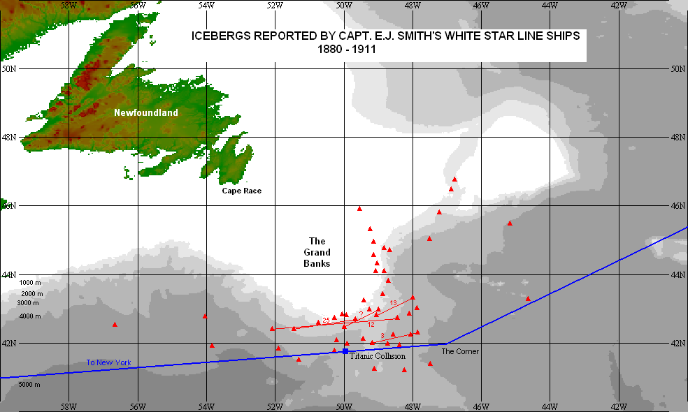
So, over the 31 years in service on steamships with the White Star Line prior to his fateful collision, Smith had seen ice during 15 of the years, or essentially half of them. Not all years were spent on North Atlantic runs. Not all ice observations may have been reported, and certainly not all would have necessarily been published, or found by the present authors. Nor did all our reports necessarily include the name of the ship. We can be sure that the nearly 50 ice reports recorded here are only part of what Capt. Smith encountered, and there can be no question that he was familiar with ice conditions in the North Atlantic. There is also no question that on several occasions he had encountered ice as far south as he would later do with the Titanic. All Captain Smith’s prior ice encounters are displayed in Figure 1 along with a typical east – west shipping route as taken by the Titanic, to give an idea of the relationship of the icebergs sighted to the ship’s track.
The ice conditions of 1912
Both the Titanic’s surviving deck officers, 2nd officer Charles Lightholler, and 4th officer Joseph Boxhall, as well as Capt. Dow of the SS Carmania which passed through the ice on 11 April, and Capt. James Moore of the SS Mount Temple which passed by the Titanic area just some hours before the collision, are quoted, or sometimes misquoted, as having never seen quantities of ice this far south. Such comments have even been attributed to Capt. Smith himself[17][18] . The authors involved do not cite their sources and it is unclear at what moment in time and to whom Capt. Smith may have made such a remark.
Describing his colourful and remarkable career Lightholler[19] recounts that in his 15 years on North Atlantic runs he had never seen ice like it before or since. Junior officer Boxhall had less experience than Lightholler and had been with White Star Lines since 1907. He too, testified at the British Wreck Commissioner’s Inquiry that he had no recollection of ice ever having been as far south as 42 N[20]. However, at the earlier U.S, Inquiry he stated that this was the first time he had seen field ice on the Grand Banks in his nine years of running to New York, although he had seen icebergs before[21].
Capt. Dow of the Carmania, on arriving at New York, is quoted as saying “I never saw so much field ice so far south before”[22], and “I have never seen so much ice and so little whisky and lime juice in all my life before”[23]. He was likely no stranger to ice on his North Atlantic runs, and as master of the Carmania had filed an ice report of an iceberg in this very area in May of the previous year[24].
At the British Inquiry Captain James H. Moore of the SS Mount Temple testified that he had never seen ice this far south in his 27 year experience, and that he had company instructions to not go into field ice no matter how light it may appear[25]. Ironically, the International Ice Patrol has the Mount Temple listed as an iceberg casualty in 1913,[26] but the authors have been unable to confirm this. The casualty list in which it appears was drawn up for publication in late 1973, and the authors suspect it may have been confused with the SS Templemore which did file ice reports in March1913, but on 30 September caught fire and was abandoned, later to be towed into Boston to the underwriters.[27] Certainly, the Mount Temple submitted ice reports in a number of years and interestingly in 1905 noted icebergs just 40 miles north of the Titanic location though with a different master at that time[28]. The ship was later to be sunk by an enemy raider in 1916.
From the above sample of quotes it appears that ice conditions in April 1912 were unusual, somehow different from the norm, but just how different were they? Basically, the recommended route for westbound traffic was to follow the Great Circle route, a sweeping arc from the south west tip of Britain to a point off the Grand Banks at 42° N 47° W known as the “corner” from which the ships resumed a more westerly course to New York, or similarly situated ports. The 42nd parallel then has become a measure of how far south to expect the ice to advance in the course of the season. This was just a guide, however, as was made clear in the final report of the Board of Trade inquiry which stated:
“It must not be supposed that the lane routes referred to had never been changed before. Owing to the presence of ice in 1903, 1904 and 1905 from about early in April to mid-June or early in July, westward-bound vessels crossed the meridian of 47° W. in lat. 41° N., that is 60 miles further south than the then accepted track.”[29]
Also:
“…. From [this chart] it would appear that whilst the southern and eastern limits of field ice are about lat. 42° N. and long. 45° W., icebergs may be met with much farther from Newfoundland; in April, May and June they have been seen as far South as lat. 39° N., and as far east as long. 38° 30´ W.”[30]
and:
“It is, in fact, impossible to give, within the outer limits named, any distinct idea of where ice may be expected, and no rule can be laid down to ensure safe navigation, …… ”[31]
and importantly in concluding that section:
“The above extracts show that it is quite incorrect to assume that icebergs had never before been encountered or field ice observed so far south, at the particular time of year when the “Titanic” disaster occurred; but it is true to say that the field ice was certainly at that time further south than it has been seen for many years.”
All too often, however, in the many books and discussion forums on the Titanic these points point are often neglected or ignored leaving the reader the impression that ice conditions in 1912 were unique. They were not.
Using 42° N as a criterion for the expected normal southerly limit for ice, we went through our compilation of iceberg records to see in how many years of Capt. Smith’s 32 years of service with the White Star Line from 1880 to 1911, icebergs drifted south of 42° N. Our compilation for this period amounts to over 30,000 records. The result is interesting in that in only 2 years of the 32 icebergs did not cross the 42nd parallel, namely in 1881 and 1910, although in the latter year a piece of ice was found in July at 39°N and far to the west of the Titanic location at 62° W. Restricting the search to the end of April produced 7 more years, for a total of 9 years, with no icebergs crossing 42° N, or only 28% of the time. Therefore, by sticking to the recommended shipping lane, icebergs could be expected to be encountered in 7 out of 10 years up to the end of April, and pretty well every year during the iceberg season. Statistically, if only one or two or a handful of bergs drift to the shipping lanes the chance of hitting one may not be very high, but it only takes one to cause a disaster, as some 255 ships during that 32 year period found to their cost. The iceberg collision data compiled by the National Research Council Canada from contemporary sources, records 255 collisions, not all of them sinkings, in this time period[32]. A report to the British Board of Trade lists 858 contacts with ice by United Kingdom registered ships over the 20 year period ending in 1911[33]. While this includes collisions with all types of ice in all parts of the world, which would include the sea ice prone waters of the Baltic Sea and the iceberg studded Antarctic waters, there is little doubt most of the collisions would have occurred in the waters of the Grand Banks. It is an impressive number.
If, then, ice could reach as far south as the latitude of the Titanic collision in almost every year, then just how bad was 1912? And were there other years like it? It is a question difficult to answer objectively since numbers themselves may not provide the complete answer. The severity of ice conditions in 1912 was due largely to the combination of field ice and icebergs, and the rapidity with which they encroached upon the shipping lanes. We have over 2500 iceberg and field ice records for 1912 with some 650 up to the end of April. Many of the records describe more than one iceberg. No doubt many records describe the same berg or bergs seen by another ship perhaps on a different date, and no doubt the Titanic tragedy itself spurred on more ships to report, but nevertheless the large number of records does reflect the severity of the ice conditions.
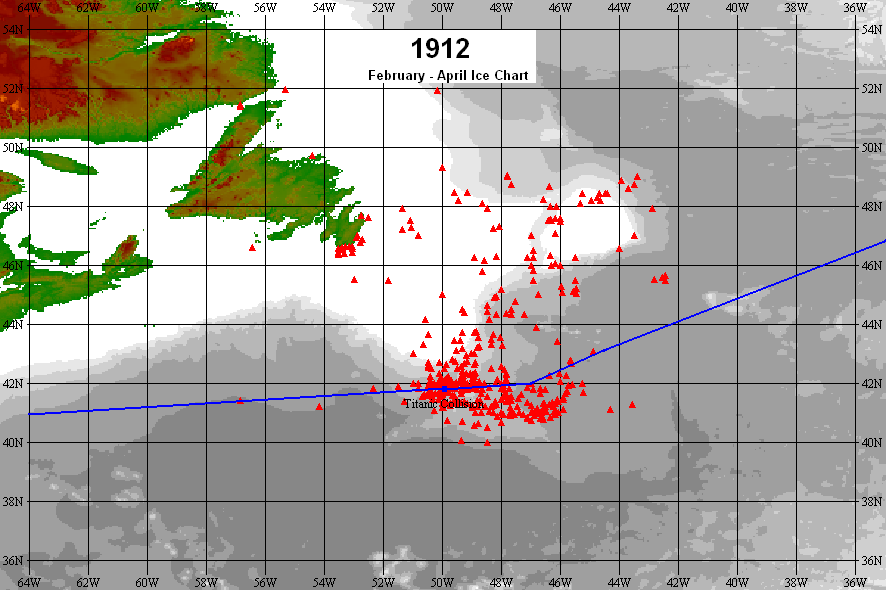
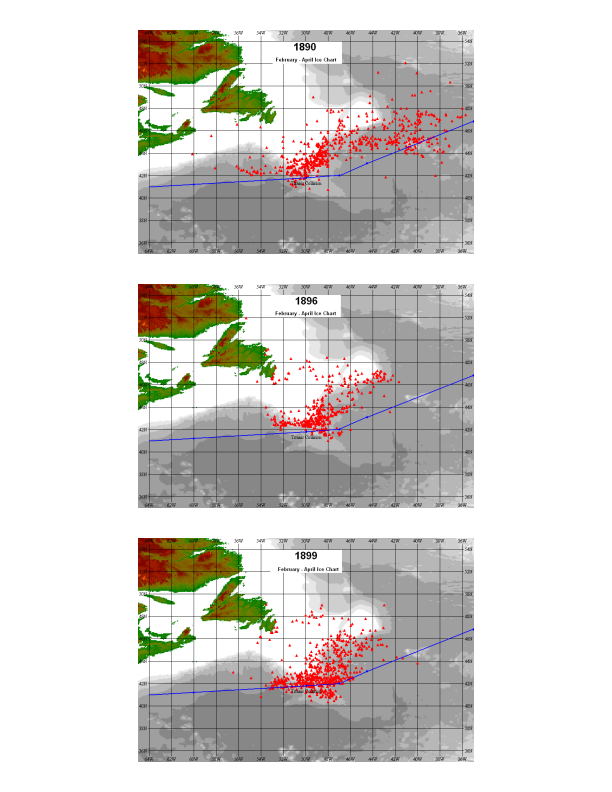
Figure 2 shows all the iceberg records for 1912 from February until the end of April along with the approximate track taken by steamers to the corner and beyond. This provides a reference in comparing with other years, and as an initial criteria we selected only those years in which the iceberg records were greater than 2000. This gave us 1890, 1896, and 1899, and the records for February through April for each of these years are shown in Figure 3. The iceberg distribution for each of these years differs slightly one from the other but there is little doubt of their severity and 1899 is remarkably similar to 1912. Two of those reports in 1899, very close to where the Titanic went down were provided by the SS Majestic, commanded by Capt. Smith. It is probably no coincidence that the first agreement to adopt specific shipping lanes began in 1891, after the catastrophic year of 1890 in which 18 ships collided with icebergs (mild in comparison to 32 in 1885)[34]. Those iceberg collision numbers are separate from those which were damaged by field ice. Any ship which sailed into field ice was likely to suffer damage to a greater or lesser degree and would be fortunate to escape with little more than a few dented plates, or bent, or broken propeller tips. Capt. Smith was on the SS Coptic on the New Zealand route for the first few months of 1890, and there is no evidence of him being back on the North Atlantic runs until December, so he missed this particularly heavy ice year though surely would have heard about it by word of mouth subsequently.
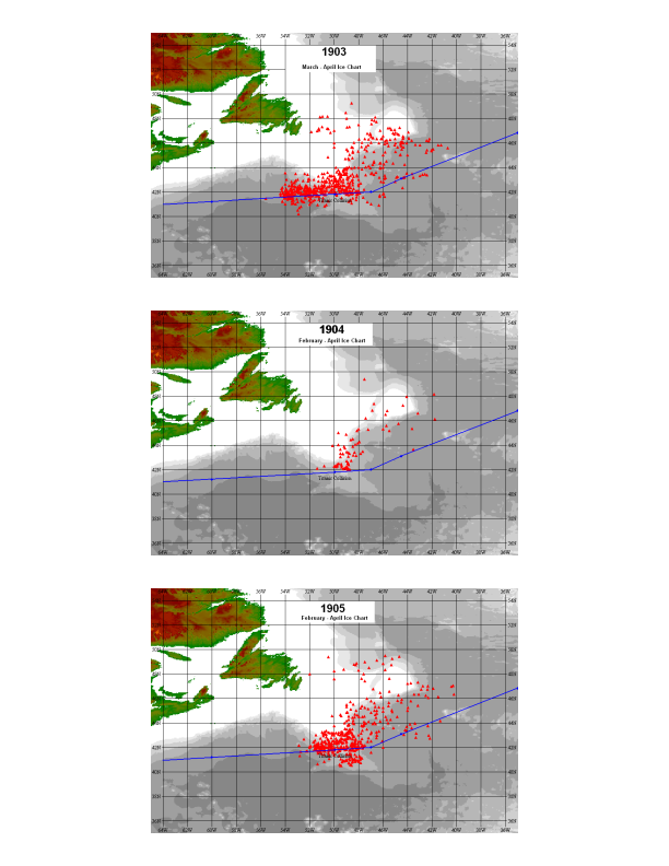
Those recommended tracks, however, were basically the shortest route to skirt the ice in an average year and required modification should a worse than average year occur. Such eventualities were noted at the British Board of Inquiry (BOT) into the sinking of the Titanic when it was pointed out that in 1903, 1904 and 1905 the westbound lane had been moved 60 miles further south to skirt the ice at some point during the ice season[35]. Charts of the iceberg conditions for February through April for these years are shown in Figure 4. It is apparent that while 1903 and 1905 were extensive in iceberg numbers, 1904 was not. Indeed there are only about 85 iceberg records for those months in 1904 out of a total of 500 for the season, compared with approximately 700 and 1500 respectively for 1903 and 1905. Evidently 1904 is a mistake in the commissioner’s report and there is nothing in the records we have that indicate a lane change in that year. Although noting changes to steamer routes was not an objective in our initial search of ice information in the Hydrographic Bulletin records, we can identify 1896[36] and 1897[37] as additional years in which lane changes were made. Although some text has been truncated in our photographic images there is enough evidence to suggest that this was the case in 1906 also. It may be that 1904 in the BOT report was mistaken for this year. Therefore, in the 21 years prior to 1912 since shipping lanes were adopted, there is evidence that the tracks were altered to the south in at least 5 of them or basically 25% of the time. This is not a huge number but enough to show that even with the new winter adopted steamer tracks, ice could still be a problem.
From the above, although 1912 was a very bad year for ice, we know of at least three years in the preceding 20 for which conditions were as severe, and ice reached 42° N in almost all years. But how about the years afterwards? If Charles Lightholler and others were not quite correct in suggesting that 1912 was the worst ice year up until that point, was he correct in saying that there was not a year like it since either? Although Lightholler did not see much more service on the North Atlantic runs, joining the Royal Navy in World War One he retired from active service in 1919. After an additional short time with the White Star Line he retired from that too, but he does appear to be essentially correct.
The severe ice conditions which had been plaguing the North Atlantic routes for the past three decades reached their nadir in 1912 after which conditions, although still bad, slowly began to improve. For the next decade or so bergs reached 42°N every year and in only one year did they not reach that latitude by the end of April. The steamer tracks were still repeatedly moved seasonally southwards but the bergs reaching this far south were dwindling. Ice reports were sometimes still in the thousands, over 3,400 in 1922, but only 57 passed south of 42° N in that year, as compared to the several hundred seen in some of the years during the 1900s and in 1912. Then, starting about 1924 conditions ameliorated even further in a trend seen universally across the North Atlantic sector at least. While the number of iceberg reports actually appears to increase in the following years this could be due to increased awareness and better ice observation programs. The number of bergs reaching 42°N dropped substantially in the 10 year span 1925 – 1934 with only one berg reaching 42°N by the end of April. Comparing the whole iceberg season, the number of bergs reaching 42°N was less than half that of the previous decade. The sea ice record for the Canadian east coast and Grand Banks area also shows a dramatic decline during this time.
In fact, the period of service Capt. Smith spent with the White Star Line was at a time when ice conditions in the western North Atlantic were the worst in the 200 year record starting from about 1810. Variability from year to year can be considerable but there appears to be a general downturn in conditions starting about 1880. In general, we appear to have better reporting of ice conditions from about that time. Prior to that time, even in years when conditions appeared to be fairly severe, records are often sparse. As ice conditions deteriorated after 1880, there not only appears to be an increasing awareness of floating dangers, but there had also been sufficient technological advances for information from steamers, to be easily passed between interested agencies and published in readily available journals and newspapers. The early 1880s saw a number of different publications in North America such as the New York Herald and the New York Maritime Register listing an increasing number of ice reports in their columns. The sudden increase of ice in 1882 saw the Monthly Weather Review of the General Weather Service of the United States[38] start publishing ice information under a separate heading of “Ocean Ice”. Spectacular evidence of the chilling of New England coastal waters was demonstrated by the finding of millions of floating dead tilefish described by Capt. J.W. Collins[39] in 1884 and discussed in detail more recently by Marsh et al,[40] and believed to be related to an increase in strength of the Labrador Current. The ash clouds from the catastrophic volcanic destruction of the island of Krakatoa in 1883 is thought to have lowered global temperatures by one degree Celsius, its affect lasting for the next few years and this undoubtedly had an additional influence on ice severity. Whatever other causes, and the reduction in solar activity may well be one of them[41], the era of anomalous ice conditions would last another 40 or so years until the early 1920s[42].
In the modern era, iceberg numbers remain very variable but there have been some instances recently with very few, if any, bergs drifting south to threaten the traditional shipping routes. One comment by Cunard’s Commodore Ronald Warwick in 2006is worth noting as on occasion he has been misquoted. As if giving credence to the notion that icebergs rarely now get as far south as the Titanic, it is implied that he had never seen any icebergs on this track. While true, it is not exactly what he said. He stated was that on receiving iceberg warnings from the International Ice Patrol he promptly diverted 20 to 25 miles to the south[43]. So heeding these warnings he would not have seen any icebergs, or have been anywhere near them – a sharp contrast to the attitudes of the shipping lines a hundred years previously, when they were quite willing to risk vessel and cargo rather than take that extra mile. This is quite evident from the ice charts reproduced here showing the location of the bergs in relation to a typical steamer track. The tracks are willfully designed, not to totally avoid the ice, but to skirt through its outer fringes as if in some reluctant gesture to reduce the chance of collision without actually eliminating it. While studying the ice charts one also has to remember that this is an era before the age of flight and that each one of the iceberg symbols represents an ice report from ships. Even if some of these ships were heading from, or to, ports more northerly than New York, if the shipping lines of the day had had the same attitude as Commodore Warwick, there were would be very few symbols on these charts. Even in the years before wireless communication there was sufficient high speed steamer traffic and telegraph communication that could fairly rapidly spread word of encroaching ice, which moves relatively slowly. The treacherous routing of ships did not go unnoticed at the British Inquiry which pointed out that moving the “corner”, or turning point, from 42° N 47° W to 38° N 45° W added only 220 miles to the route or 10 hours sailing to fast steamships. This route was subsequently adopted[44] though the reluctance in adding what amounts to about 7% more in distance and time and the resultant 7% additional expense in coal and commodities can be imagined.
The Winter of 1912
The ice conditions in 1912 were one of the worst known and it occurred during a 40 year period of generally bad ice years. Yet, it is curious to read in many books and articles, some recently published, of how the 1912 condition stemmed from an abnormally warm Arctic winter and spring, during which large amounts of ice had broken free and drifted south. It is something even Charles Lightholler stated in his narrative in 1935, so where did he get this information from? Who would have known this? The Arctic is a huge place and in 1912 was largely unoccupied, certainly in the western hemisphere. There were a few scattered communities along the sub-Arctic and Arctic coasts of western Greenland and along the sub-Arctic coast of Labrador but all of those, except for the southerly ports of Greenland, would be ice-bound and having no wireless would have no communication with the rest of the world until shipping resumed.
The origin of the mild winter theory appears to be a full page article entitled “Prevalence of Icebergs due to Warm Arctic Winter” which appeared in The New York Times[45] published on 5 May 1912 just three weeks after the Titanic collision. It is an interesting article for it displays the state of knowledge of icebergs and their drift at that time, which was basically correct but nevertheless displays inconsistencies and contradictions. A substantial part of their argument that a mild winter was the cause of the heavy ice lay with statements supposedly made by Donald B. MacMillan, companion of Robert Peary in his 1909 North Pole expedition. According to one paragraph he was currently then in Labrador and yet in another is recorded as stating that the past winter had been uncommonly mild in the entire Arctic. Since he was known to be in New York at an anniversary function of the polar journey just a month previously[46] it would be impossible to be in both places at the same time. Also, how could any one person know what the winter was like in the whole Arctic when there was no communication. There is much of merit in the newspaper article, but in its attempt to explain the severe ice conditions then prevailing in the North Atlantic, there is much muddling of details and of snapshots taken at different places and times, to arrive at the erroneous concept that mild winter weather was the cause. This is a mistaken concept which has survived a hundred years and is still repeated. But they were correct, however, in assuming that strong northerly and north-westerly winds would drive the ice to low latitudes.
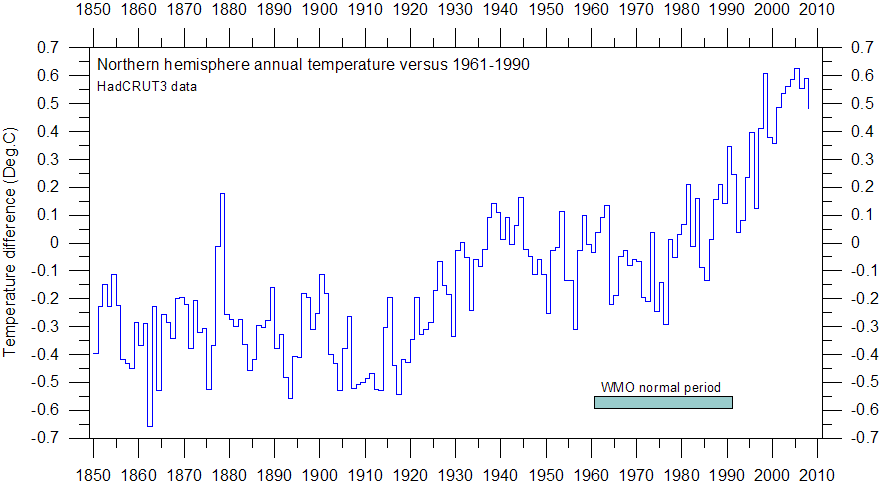
In fact, 1912 was one of the coldest years on record in the northern hemisphere[47] and globally[48], and was the second coldest in the mainland U.S., where the winter months set notable records[49] as Arctic air pushed southwards. Temperature data extending back to 1912 and earlier have been recorded at a number of stations in Western Greenland, from the sub-Arctic at 61° N to 72° N in the Arctic waters of Baffin Bay, as well as one station in Labrador and there is nothing to suggest unusually warm temperatures in 1911 or 1912. Indeed, the 12 year period from the early 1900s until 1914 is characterized by a strong winter North Atlantic Oscillation index, a measure of the atmospheric pressure gradient, during which northerly winds predominated. This cold northerly flow enhanced the growth of sea ice and this in turn protected the icebergs. This was the reason for the heavy ice conditions not some non-existent abnormally warm winter.
Concluding remarks
Captain Smith was a commander of considerable experience, had met ice on several occasions on his frequent voyages across the Atlantic and was well aware of how far south the ice could drift. Meeting ice on his Titanic voyage “so far south so early in the season” was undoubtedly of no surprise, although he might have been surprised at the large quantity as that was a relatively unusual occurrence. According to the testimonies at the inquiries it was normal procedure to continue into the ice zone until ice was observed, before taking any cautionary measures, and this Captain Smith chose to do regardless of warnings of ice ahead. It was standard procedure and the ice charts displayed here make it clear that the captains were little more than pawns in a game of chance in risking their ships and human cargo at the demands of their employers, who regarded safety as second place to maintaining fast transit times and rigidly prompt schedules. If the shipping lines had been serious about minimizing the risk of collision with ice there would be precious few ice reports, as even with late 19th and early 20th century technologies they were well forewarned and could easily have given the ice a wide berth. And they knew it, too.
An editorial appeared in the New York Times dated 25 June 1880[50], 32 years before the Titanic disaster, entitled “Ice in the Atlantic Ocean. The question of high speed and fogs. The Admiralty Charts – limits of ice – Are Captains reckless?– Who is to be blamed?” It is just one of many published critiques of the ensuing period questioning the wisdom of plowing across the Atlantic at ever increasing speeds regardless of fog, ice and derelicts, the last seen by many as an even greater problem. There were calls for some kind of Atlantic patrol to observe, monitor and warn of these navigational dangers. The publication of the Hydrographic Bulletin of the U.S. Hydrographic Office starting in 1889 warning of “obstructions and dangers along the coast and the principal ocean routes” was a direct response to some of those issues. It is interesting to note that the book “Futility” otherwise known as the “Wreck of the Titan”[51] was published a few years later anticipating with remarkable accuracy the disaster which was to occur with its near namesake 14 years later; a disaster which all too many by then were recognizing as unavoidable. A New York Times article on the dangers of ocean racing published in November 1890, just as the speed of transiting ships was reaching the 20 knot threshold stated, “… is especially true in in the case of submerged icebergs, where a crash at full speed, say twenty knots, would leave nothing of the ship, passengers, or freight except bills of lading, freight receipts, and insurance policies.”[52]
Acknowledgements
The authors would like to thank the staff of the Maritime History Archives of the Memorial University of Newfoundland and Labrador, St. John’s, and the National Archives and Records Administration, College Park, Maryland, for the friendly and efficient services. Accessing and photographing the Hydrographic Bulletins was funded in part by National Science Foundation grant 0629500 administered by the Institute for Arctic and Alpine Research at the University of Colorado. The charts and plotting software are provided by GEBCO Digital Atlas.
Endnotes
[1] Lieutenant Matthew M. Maury, Explanations and sailing Directions to accompany the Wind and Current Charts. Philadelphia, 1855, Steam Lanes Across the Atlantic, pp 308-321. Maury actually credits R.B Forbes, ship owner and builder of Boston , for proposing the idea.
[2] The New York Times 4 August 1889 p.15 c.3 “Slow Trips and Icebergs”.
[3] U.S. Hydrographic Office, Washington, 11 September 1912. The Titanic Disaster, Steamship Lanes, and the Establishment of the Ice Patrol: The 1912 report of the Hydrographer, U.S. Navy, accessed at http://www.history.navy.mil/faqs/faq94-1.htm October 2013.
[4] These are in collections called the Newfoundland Ice Extent, The Gulf of St. Lawrence Ice Exent, and the Iceberg Sightings Database which can be found at www.newicedata.com
[5] Record Group 287 in the College Park facility, found in Stack B190, Row 17, Compartments 5 and 6,
[7] History Press, UK. 2012
[8] http://www.encyclopedia-titanica.org/forums/captain-edward-john-smith/18874-captain-smiths-ships-2.html dated 17 September 2005 accessed November 2013
[9] John P. Eaton (2005) A Captain’s Career Voyage (ref: #4696, accessed 11th November 2013 at: http://www.encyclopedia-titanica.org/titanic-captain-smith-a-captains-career.html
[10] Ruffman, Alan. 2000. The position of Titanic’s lifeboats on recovery. Voyage 33, Titanic International Society, Inc., Summer, pp. 42-43. Estimated Titanic collision position of 41°46’36″N, 49°56’48″W
[11] Liverpool Telegraph & Shipping Gazette 26 August 1889 p.1 c.1, Entered Docks Since Our Last. Celtic, Smith
[12] According to the Liverpool Telegraph & Shipping Gazette 24 Oct, 16 Nov, 20 Nov and 14 Dec 1889 the Adriatic, Smith, made two voyages to New York in this period.
[13] Lloyd’s List 22 Feb 1890 p.7 c.12 departed Canterbury, NZ, Feb 20, Smith. LL 8 April 1890 p.4 c.1 arrived London. Smith does not appear to have made any further voyages until December.
[14] Liverpool Telegraph & Shipping Gazette 16 March 1891 p.1 c.1 Adriatic, Smith, Arrived in the River from New York.
[15] Both Gary Cooper & Charles Haas indicate that Smith commanded the Runic in March and April but it appears he may have only done so briefly while in dock. There is a largely illegible entry in Lloyd’s Captains Register which hints that he might have been in charge about March 26, maybe to oversee loading, as the departure according to the Liverpool Telegraph & Shipping Gazette 27 March 1891 p.1 c.1 has Capt. Thompson as its master on departure on the 26th March and master on its return on 29th April, in the 29 April issue p.1 c.1. However, the same newspaper lists the Adriatic, Smith, in the Alexandra Docks then the Hornby Docks continuously from its return on 16 March until at least the end of June.
[16] All miles in quoted text are taken as nautical miles (nm).
[17] Ballard, Robert D and Rick Archbold. Lost Liners. Madison Press. 1997. “ Never in Captain Smith’s experience had the ice been so far south this late in the season.” whereas, in fact, the peak of the iceberg season is normally May – June.
[18] Historic UK at http://www.historic-uk.com/HistoryUK/HistoryofBritain/RMS-Titanic-the-unsinkable-ship/ Titanic‘s Speed. “His years of experience at sea suggested little risk of ice so far south at that time of year.” accessed October 1913.
[19] Lightholler, Charles Herbert. Titanic and Other Ships. Gutenberg of Australia eBook, Chapter 31 at http://gutenberg.net.au/ebooks03/0301011h.html#ch31 accessed October 2013. 1st. Edition published 1935.
[20] British Wreck Commissioner’s Inquiry Day 14 Testimony of Joseph G. Boxhall questions 16962 & 16963 at http://www.titanicinquiry.org/BOTInq/BOTInq14Boxhall01.php accessed October 2013
[21] U.S. Senate Inquiry http://www.titanicinquiry.org/USInq/AmInq03Boxhall07.php accessed October 2103. However, a few days later he was to testify that he had quite a lot of experience in field ice: http://www.titanicinquiry.org/USInq/AmInq10Boxhall01.php . If he had not experienced field ice on the Grand Banks then without further investigation it is not clear where he got it though possibly it was spring runs up the Gulf of St. Lawrence or the summer northern route through the Strait of Belle Isle to Montreal.
[22] New York Times 16 April 1912 p.6 c.1 “Northern ice Packs Broke Up Very Early”
[23] New York Times 15 April 1912 p.2 c.1-2 “Carmania in Icefield”
[24] Hydrographic Bulletin No. 1134 24 May 1911. A berg about 300 feet long and 50 feet high in 42°06´ N 49°49´ W.
[25] British Wreck Commissioner’s Inquiry Day 8 Testimony of James H. Moore questions 9388 & 9412 at http://www.titanicinquiry.org/BOTInq/BOTInq08Moore01.php#a9388 accessed October 2013
[26] Report of the International Ice Patrol Service in the North Atlantic Ocean. Bulletin No.59. The Season of 1973. Appendix A p. A-3. The reference to the Mount Temple collision is unusually vague with no date except for 1913 with unknown damage somewhere on the Grand Banks.
[27] Irving H. King. The Coast Guard Expands: New Roles, New Frontiers. U.S. Naval Institute Press. 1996 pp.143-144. However, the given date of catching fire on 13 October appears to be wrong; see the Board of Trade Wreck Report for ‘Templemore’, 1913 at http://www.plimsoll.org/resources/SCCLibraries/WreckReports2002/20220.asp?view=text accessed December 2013
[28] HB 26 April 1905. Apr 13. Lat. 42°45´ lon. 49°, to lat. 42°20´, lon. 50°, passed several medium sized icebergs and numerous small ones – Mount Temple (Br. ss), [Capt.] Forrester.
[29] British Wreck Commissioner’s Inquiry final report Account of Ship’s Journey across the Atlantic/ Messages Received/ Disaster Route Followed at http://www.titanicinquiry.org/BOTInq/BOTReport/botRepRoute.php accessed Oct. 2013
[30] Ibid., quoting “United States Pilot (East Coast),” part I. (second edition, 1909, p.34)
[31] Ibid., quoting “United States Pilot (East Coast),” part I. (second edition, 1909, p.35)
[32] Hill, Brian T. Database of Ship Collisions with Icebergs. Report of the International Ice Patrol Bulletin in the North Atlantic. 2000 Season, Bulletin No.86, CG-188-55 updated on https://newicedata.com
[33] Report to the Merchant Ship Advisory Committee respecting The Statutory Regulations as to Boats and Life Saving Appliances and other means of ensuring Safety of Life at Sea. Merchant Shipping . His Majesty’s Stationary Office, London. 1912. Table 16. p.166.
[34] Hill, Brian T. Database of Ship Collisions with Icebergs. Report of the International Ice Patrol Bulletin in the North Atlantic. 2000 Season, Bulletin No.86, CG-188-55 updated on www.newicedata.com
[35] British Wreck Commissioner’s Inquiry final report Account of Ship’s Journey across the Atlantic/ Messages Received/ Disaster Route Followed at http://www.titanicinquiry.org/BOTInq/BOTReport/botRepRoute.php accessed Oct. 2013
[36] HB No. 35120 May 1896: “On May 14 a number of bergs showed themselves between 42°N and 43°N and 52° and 53½°, directly in the adopted steamship routes.”, and HB No. 353 3 June 1896. “The decrease in the number of ice reports is probably due to the fact that many transatlantic liners are now taking a more southerly course. … No icebergs have yet reached the 41st parallel.”
[37] HB No. 401 5 May 1897: “Temporary Change of Routes. Owing to the large amount of ice this year, the different trans-atlantic steamship companies have directed their steamers to cross the 49th meridian in lat 41°, westward bound, and lat 40°10´, eastward bound, during the ice season. J.E. Carr, Commander, U.S.N., Hydrographer.
[38] Monthly Weather Review (General Weather Service of the United States), War Department, Chief Signal Officer, Telegrams and Reports for the Benefit of Commerce and Agriculture, Washington, D.C., 1872
[39] Collins, J. W. 1884. History of the tile-fish. Rep. U. S. Comm. Fish. for 1882, App. B, p. 237-294. accessed at http://penbay.org/cof/COF_1882_XI.pdf December 2013
[40] Marsh, R., B. Petrie, C. R. Weidman, R. R. Dickson, J. W. Loder, C. G. Hannah, K. Frank, and K. Drinkwater. 1999. The 1882 tilefish kill – a cold event in shelf waters off the northeastern United States? Fisheries Oceanography 8:39-49.
[41] Hill, Brian T. and Stephen J. Jones. The Newfoundland Ice Extent and the Solar Cycle From 1860 to 1988 Journal of Geophysical Research: Vol. 95, No. C4, pp 5385-5394, April 15, 1990
[42] https://newicedata.com/newfoundland-ice-extent/
[43] Cunard’s Legendary Captain Warwick accessed November 2013 at www.cruisecritic.com/articles.cfm?ID=293:
[44] British Wreck Commissioner’s Inquiry final report Account of Ship’s Journey across the Atlantic/ Messages Received/ Disaster Route Followed at http://www.titanicinquiry.org/BOTInq/BOTReport/botRepRoute.php accessed Oct. 2013
[45] The New York Times 5 May 1912 Part 5 Magazine Section p.6.
[46] The New York Times 6 April 1912 p.11 c.3 “Peary sure Scott’s Party got to the Pole”.
[47] http://www.climate4you.com/images/NH%20MAATvs1961-1991since1850.gif accessed November 2013
[48] http://www.cru.uea.ac.uk/ accessed November 2013
[49] http://en.wikipedia.org/wiki/1912_United_States_cold_wave accessed November 2013
[50] The New York Times 25 June 1880 p.2 c.6
[51] Futility. Morgan A. Robertson. 1898. M.F. Mansfield. New York.
[52] The New York Times 13 November 1890 p.9 c.1 “The Risk in Ocean Racing”.