1950 Season
Dec 6 Last eastbound steamer through the Strait of Belle Isle. (WBB)
Dec 8 Last departure of the season from Quebec. (WBB)
Jan 2/3 Georgetown – The steamer to load potatoes is expected to dock here on Monday or Tuesday. (Pat 7 Jan p5 c6)
Jan 6 Issue: The St. Lawrence River was free of ice all the way to the Atlantic and weather officials said it was the greatest January warm spell in 75 years. (Pat 6 Jan p10, c6)
Jan 6 Grindstone, Magdalen Islands – “drowned yesterday when he fell through thin ice near his home at Etang Du Nord.” (Pat 7 Jan p5 c6)
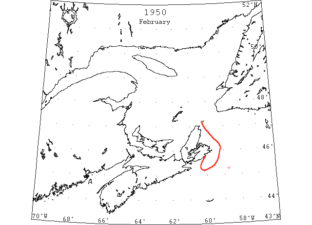
Feb Reports of ice in Cabot Strait and the Gulf of St. Lawrence were practically nonexistent. The only report received indicated that some drift ice had reached the vicinity of Misaine Bank on the 21st. (IIP, P6).
Feb 21 45°11’N 60°11’W. Encountered light close packed field ice with some heavy pieces. Signs of ice to north and west with patches to south and east. (IIP p23#26).
Mar From the 8th of March on reports of ice in Cabot Strait increased in frequency. On this latter date the limits were from Scatari Island to 45°30’N 59°35’W to 45°36’N 57°45’W to 46°00’N 57°10’W to 46°55’N 57°45’W to Cape Ray. Its maximum seaward extension for the month occurred in the 21st when it reached the vicinity of 44°20’N 57°00’W. It remained in this vicinity until the 28th when it southeastern limits were from 44°30’N 58°40’W to 44°35’N 57°30’W to 45°00’N 56°50’W. (IIP, P7).
Mar 8 DOT aerial survey: Outer limits from Cape Ray to 46°55’N 57°45’W to 46°04’N 57°08’W to 45°37’N 54[57?]°45’W to S extremity 45°30’N 59°36’W to vicinity of Scatari with strip along coast to St. Esprit. Within these limits to Cape Breton coast 70% heavy loose ice. (CIS IC0913_2)
Mar 8 DOT aerial survey: George Bay blocked. (CIS IC0958)
Mar 8 DOT aerial survey: Sydney harbour open to bar, approaches closed. (CIS IC1024_3)
Mar 8 DOT aerial survey: Survey gulf and Cabot Straits shows conditions about average for season. Whole area practically covered with light to heavy ice, light ice is of recent formation. (CIS IC0742_8)
Mar 8 DOT aerial survey: Heavy drift W of a line from North Point, PEI to Bonaventure Island, 60% newly formed sheets, 40% heavy. E of line heavy close pack with few strings of open water. Bonaventure Island to Fame Point heavy open and close pack. (CIS IC0784)
Mar 8 DOT aerial survey: From Fame Point across to Anticosti heavy sheets with numerous small lakes. Along S coast of Anticosti, SW to South Point open water extends southward 5 to 10 miles from Anticosti to Bird Rocks, Cape St. George, Cape Anguille, Cape Ray heavy sheets with numerous small lakes. (CIS IC0790_3)
Mar 12 45°35’N 57°59’W. Concentration of field ice. (IIP p26#117)
Mar 12 45°28’N 57°36’W. Heavy slob ice. (IIP p26#116)
Mar 16 45°17’N 58°14’W. Extensive ice with tongue extending southwest to 45°00’N 58°19’W. (IIP p27#139)
Mar 16 45°00’N 58°00’W. Edge of field ice. (IIP p27#140)
Mar 16 DOT aerial survey: Outer limits from Cape Ray to 47°50’N 57°40’W to 45°30’N 57°17’W to 44°41’N 57°30’W to 45°10’N 59°00’W to SW extremity, 45°15’N 60°20’W to 5 miles off St. Esprit taking shore at Guion Island. Within these limits to Cape Breton shore approximately 60% ice. (CIS IC0913_3)
Mar 16 DOT aerial survey: N side Bay of Chaleur opening, with slob extending 5 to 10 miles off coast to Cape Gaspe. (CIS IC0923_2)
Mar 16 DOT aerial survey: N entrance and George Bay close pack, extending up NW coast of Cape Breton and westward to within 2 to 10 miles of PEI coast. (CIS IC0958)
Mar 16 DOT aerial survey: A heavy movement of ice through Cabot Strait to Atlantic has relieved pressure in Gulf, and opened up large areas over steamer track and off Cape Breton coast. (CIS IC0742_8)
Mar 16 DOT aerial survey: W of a line from 5 miles off West Point to Miscou newly formed slob with open water along New Brunswick coast to limit of visibility. (CIS IC0784)
Mar 16 DOT aerial survey: From 48°24’N 64°14’W SE over steamer track to 40 miles NW of Bird Rocks, a track approximately 25 miles wide with scattered drift and slob. From this position to St. Pauls, Cape Ray and seaward, heavy ice. (CIS IC0790_4)
Mar 20 45°05’N 60°10’W to 44°55’N 59°35’W. Widely scattered areas, navigable field ice. (IIP p27#154)
Mar 21 45°04’N 60°10’W to 44°56’N 59°45’W to 44°56’N 57°30’W to 44°43’N 57°25’W. Southern limits of field ice. (IIP p28#163)
Mar 21 44°29’N 57°13’W to 44°14’N 57°00’W. Widely scattered ice. (IIP p28#164)
Mar 21 DOT aerial survey: Outside limits of gulf ice from Cape Ray to 46°40’N 57°40’W to 45°18’N 57°00’W to 44°35’N 57°05’W to 44°44’N 58°45’W to 45°03’N 60°14’W thence in northeasterly direction to vicinity of Scatari. Within these limits 70% ice in northern area, 50% in southern. (CIS IC0913_3)
Mar 21 DOT aerial survey: Continued improvement. Conditions in gulf compare favourably with same date last year. (CIS IC0742_8)
Mar 21 DOT aerial survey: Except for ice on harbours and Bay of Chaleur clear water W of line from North Point, PEI to Bonaventure Island, thence to Gaspe close pack. (CIS IC0784)
Mar 21 DOT aerial survey: From position 25 miles N of Cape Gaspe loose ice extends westward on Gaspe side to limit of visibility, 30 miles. Anticosti side newly formed slob from N shore. From this position eastward over steamer track there is a wide open track to 10 miles E of Bird Rocks. Thence to Cape Ray heavy ice with narrow leads. Northward to Cape St. George and southward to St. Pauls more closely packed. (CIS IC0790_4)
Mar 22 44°22’N 57°56’W. Detached areas of field ice 3 miles in diameter. (IIP p28#179)
Mar 22 44°35’N 56°35’W. Scattered ice extending 2 miles in a northerly direction. (IIP p28#180)
Mar 22 44°21’N 57°56’W to 44°25’N 57°19’W to 45°00’N 56°37’W. Large areas of drift ice. (IIP p28#187)
Mar 25 44°21’N 57°56’W to 44°25’N 57°19’W to 45°00’N 56°37’W. Southern limits of drift ice. (IIP p29#261)
Mar 26 Outer limits from 10 miles off Cape Ray to 46°58’N 57°57’W to 46°05’N 57°10’W to 45°30’N 57°00’W to 45°00’N 57°15’W to 44°48’N 58°58’W to 45°20’N 60°30’W to 15 miles off St. Esprit, thence to vicinity of Scatari. Within these limits and Cape Breton shore about 70% ice, northern area open and scattered in southern, very heavy on western edge S of St. Esprit. (CIS IC0913_3)
Mar 26 DOT aerial survey: N side of Bay of Chaleur open to limit of visibility, 40 miles. (CIS IC0923_2)
Mar 27 44°30’N 58°40’W. Southern edge of drift ice extending in a northwesterly and northeasterly direction. (IIP p29#264)
Mar 27 44°40’N 57°05’W. Strip of field ice. (IIP p29#265)
Mar 27 44°35’N 57°30’W. Encountered scattered fields of ice extending as far as eye can see northward and eastward. (IIP p29#266)
Mar 27 DOT aerial survey: From 20 miles N of Cape Gaspe eastward over steamer track clear track 30 miles wide to 15 miles N of Bird Rocks then 15 wide to 25 miles E of Bird Rocks. Thence to 10 miles off Cape Ray track blocked with heavy ice extending southward to Cape North and E to Cape Anguille. (CIS IC0790_4)
Mar 30 45°19’N 60°13’W. Entered southernmost edge of field of brash ice concentration 60 percent with few small growlers. (IIP p30#288)
Mar 31 USCGC “Sorrel”: Drift ice 45°23’N 60°10’N to 45°28’N 58°14’W. (IIP p30#292)
Mar 31 USCGC “Sorrel”: Close packed ice 45°28’N 58°14’W to 45°55’N 57°45’W. (IIP p30#293)
Mar 31 USCGC “Sorrel”: Scattered ice 45°55’N 57°45’W to 46°34’N 57°38’W. (IIP p30#294)
Mar 31 DOT aerial survey: W side of George Bay clear, E side close pack extending up coast of Cape Breton and westward to within 2 to 10 miles of PEI. (CIS IC0958_2)
Mar 31 DOT aerial survey: Outside limits of Gulf ice from 5 miles off Cape Ray to 47°05’N 57°55’W to 45°50’N 56°45’W to 45°05’N 58°05’W to 45°35’N 60°07’W to 15 miles off Guion Island to 5 off Scatari with shore lead 5 miles wide to Sydney. Within these limits and Cape Breton coast whole area covered with 80% ice in northern part, 60% in southern. (CIS IC1013_9)
Mar 31 DOT aerial survey: Entrance to river clear from Bonaventure Island to Anticosti and westward to limit of visibility (40 miles). Eastward from this position over steamer track wide open track to 10 miles N of Bird Rocks where string of loose ice stretches across the track, thence to 5 miles off Cape Ray track obstructed between 47°53’N 60°21’W and 47°50’N 59°40’W by 27 miles of heavy open ice. (CIS IC0790_5)
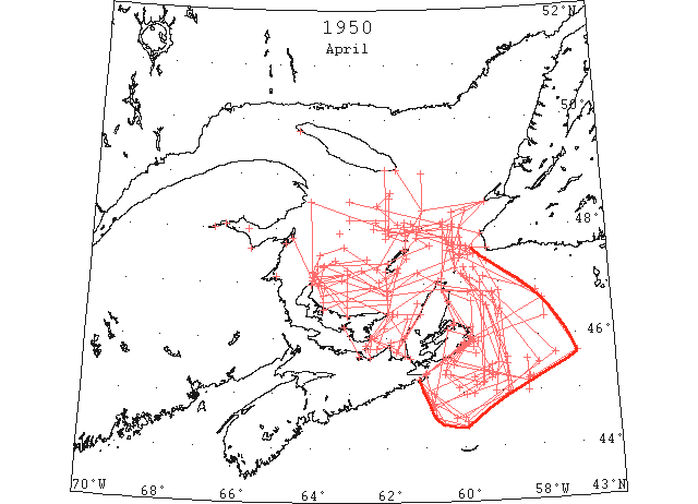
Drift ice in Cabot Strait gradually receded from its maximum seaward extension on 31 March at 56°50’W to 57°20’W on 5 April to 58°00’W on 15 April to 58°50’W on 22 April and for the last week of April it was west of 59°00’W. The southernmost latitude for drift ice in this area was reported on 17 April when it was 25 miles north of Sable Island. At the end of April the limits of drift ice were from 20 miles east of St. Paul to 46°40’N 59°10’W to 46°00’N 59°00’W to 45°00’N 59°10’W. (IIP, P8&9).
Apr 1 DOT aerial survey: N side of Bay of Chaleur navigable to Carleton. Dalhousie, Bathurst and Shippigan solid. (CIS IC0923_2)
Apr 2 DOT aerial survey: Inside the line from Scatari to 45°24’N 60°27’W numerous pieces of heavy ice. (CIS IC0913_4)
Apr 2 DOT aerial survey: George Bay full of loose ice extending up W coast of Cape Breton and westward to within 10 miles of PEI coast. (CIS IC0958_2)
Apr 2 DOT aerial survey: Heavy ice extends along E coast of Cape Breton, Cape North to Scatari. (CIS IC1021_4)
Apr 2 DOT aerial survey: Sydney harbour closed. (CIS IC1024_3)
Apr 2 DOT aerial survey: Steamer [track] from Fame Point eastward wide open and clear to 47°47’N 60°22’W where track is obstructed to 47°27’N 60°02’W with heavy loose drift and slob extending towards Cape George and taking shore at Cape Anguille. (CIS IC0790_5)
Apr 3 45°16’N 59°42’W to 45°22’N 59°20’W to 45°15’N 59°15’N thence northward. Limits drift ice. (IIP p31#342)
Apr 3 45°35’N 58°20’W to 45°13’N 58°18’W thence southward. Limits drift ice. (IIP p32#343)
Apr 3 45°15’N 58°16’W to 45°14’N 58°10’W. Limits drift ice. (IIP p32#344)
Apr 3 Ice extends along east coast Cape Breton, Cape North to Scatari. (IIP p32#357)
Apr 3 47°07’N 59°23’W to 46°50’N 58°00’W to 45°40’N 57°00’W to 45°10’N 58°20’W to 45°30’N 60°15’W to Scatari. Estimated outside limits drift ice. (IIP p32#358)
Apr 3 DOT aerial survey: George Bay about 75% loose drift extending up W coast of Cape Breton. (CIS IC0958_2)
Apr 3 DOT aerial survey: George Bay about 70% loose drift extending up W coast of Cape Breton and westward to PEI. (CIS IC0988)
Apr 3 DOT aerial survey: Sydney harbour opening, approaches closed. (CIS IC1024_3)
Apr 3 DOT aerial survey: W and N edge of ice from North Point, PEI to 5 miles off Bonaventure Island to 5 miles N of Brion Island to 10 miles S of Bird Rocks. S of this line continuous loose drift to PEI and Cape Breton coast. (CIS IC0742_8)
Apr 3 DOT aerial survey: Steamer track from Fame Point eastward wide open and clear to 47°36’N 60°20’W and closed from there to 47°32’N 60°00’W a distance of 16 miles. Closed area heavy loose drift with numerous lakes. (CIS IC0790_5)
Apr 3 DOT aerial survey: Miramichi solid. (CIS IC0801)
Apr 4 15 miles off Cape Ray to 46°50’N 58°00’W to 45°40’N 57°00’W to 45°10’N 58°20’W to 45°35’N 60°15’W. Estimated outside limits of drift ice. (IIP p32#361)
Apr 4 DOT aerial survey: Louisburg harbour and approaches, clear. Narrow shore lead westward from Louisburg inside ice. (CIS IC1083_2)
Apr 5 DOT aerial survey: Bathurst breaking up. (CIS IC0923_2)
Apr 5 DOT aerial survey: George Bay loosening up with southerly wind. (CIS IC0958_2)
Apr 5 DOT aerial survey: Louisburg harbour clear but ice in approaches moving on shore. (CIS IC1083_3)
Apr 5 DOT aerial survey: Some scattered ice at Ellis Bay and Heath Point, otherwise S coast of Anticosti clear. (CIS IC0755)
Apr 6 15 miles off Cape Ray to 46°40’N 57°50’W to vicinity Louisburg. Estimated outside limits drift ice. (IIP p32#375)
Apr 7 15 miles north-northeast of St. Paul to 46°40’N 57°50’W to 46°20’N 57°50’W to vicinity of Louisburg. Estimated outside limits of field ice. (IIP p33#394)
Apr 7 DOT aerial survey: E side of George Bay open to Henry Island. (CIS IC0958_2)
Apr 7 DOT aerial survey: Heavy ice Cape George, Cape Bear and towards East point. (CIS IC0988)
Apr 7 DOT aerial survey: Ice is moving on E coast of Cape Breton from Cape North to Scatari. Sydney harbour open but approaches closed. (CIS IC1021_5)
Apr 7 DOT aerial survey: Western and northern edges of gulf ice from Tracadie, PEI to 46°55’N 63°40’W to 47°41’N 60°48’W to Bird Rock. W and N of these lines practically clear to coast of Anticosti. (CIS IC0742_9)
Apr 7 DOT aerial survey: Steamer track from Fame Point to 10 miles off Bird Rocks to Cape Ray obstructed between 47°41’N 59°57’W and 47°40’N 59°50’W by 7 miles loose ice with open leads navigable with caution. (CIS IC0790_6)
Apr 8 East Coast Cape Breton from Cape North to Portnova. Close packed ice. (IIP p33#396)
Apr 8 DOT aerial survey: Heavy close packed in George Bay extending up NW coast to Port Hood and westward to East Point and Cape Bear, moved off shore further N to Cheticamp. (CIS IC0988)
Apr 8 DOT aerial survey: Louisburg harbour clear, ice 1 mile off shore from westward to limit of visibility. (CIS IC1083_3)
Apr 9 DOT aerial survey: Ice from the ice fields off the E coast of Cape Breton is moving S and westward from Scatari estimated 40 miles. (CIS IC0913_4)
Apr 9 DOT aerial survey: Sydney harbour and approaches blocked. (CIS IC1024_3)
Apr 10 East Coast Cape Breton from Cape North to Scatari. Close packed ice. (IIP p33#397)
Apr 10 60 miles north of Sable Island. Estimated outside limits of field ice. (IIP p33#398) (CIS IC0913_4)
Apr 10 DOT aerial survey: Heavy close packed ice along N shore of PEI extending westward to the New Brunswick coast S of Miscou and northward for about 50 miles. (CIS IC0810)
Apr 11 DOT aerial survey: George Bay close packed, extending up NW coast of Cape Breton to Margaree and westward to 5 miles off East Point and Cape Bear. (CIS IC0958_2)
Apr 11 DOT aerial survey: Louisburg harbour clear, ice 3 miles offshore from Port Nova to Guion Island. (CIS IC1083_3)
Apr 11 DOT aerial survey: Continuous northerly gales past 5 days has drifted ice, fields from NE area of gulf southward and blocked the steamer track between Bird Rocks and Newfoundland coast (Cape Ray) with 40 miles of close packed ice. Western and northern edge of ice in gulf today from a point 5 miles S of North Point, PEI to 47°15’N 62°40’W to 47°02’N 62°12’W passing about 5 miles off shore of Entry Island to N tip of Magdalens and extending northwards from Bird Rocks to a position 48°20’N 61°00’W and northward to the end of visibility 40 miles from this point. W of these positions no ice sighted. From position 48°20’N 61°00’W ice extends eastward to Cape St. George, Nfld. Open water E of a line from 48°20’N 59°50’W to 47°37’N 60°12’W to St. Paul’s. (CIS IC0742_9 & IC0846_2)
Apr 12 From 5 miles off Cape North to 46°48’N 59°10’W to 46°24’N 59°02’W. Outside limits field ice. (IIP p33#410)
Apr 12 DOT aerial survey: Close packed ice along E coast of Cape Breton, Cape North to Scatari extending S and W from Scatari. (CIS IC1021_5)
Apr 12 DOT aerial survey: Ice 8 miles off shore extending from Port Nova to 2 miles off Guion Island to a position – 18 miles ESE of Green Island. Louisburg harbour clear. (CIS IC1083_3)
Apr 12 DOT aerial survey: W and N edge of ice in gulf from a point 5 miles S of North point, PEI to 47°15’N 62°40’W to 47°02’N 62°12’W to 5 miles off Entry Island to N end of Magdalens, extending northward from Brion Island to 48°20’N 61°00’W and northward from this position to end of visibility 40 miles. W of these positions no ice sighted. (CIS IC0742_10)
Apr 12 DOT aerial survey: Over steamer track Bird Rocks to Cape Ray track obstructed by about 40 miles of open and close packed ice between 48°06’N 61°18’W and 47°44’N 60°13’W, clear E of this position. SS “Beaverglen” passed through this ice at noon today. (CIS IC0846_2)
Apr 13 DOT aerial survey: Cape North to 46°50’N 59°10’W to 45°40’N 57°35’W to 44°32’N 59°59’W (30 miles north of Sable Island) to 44°58’N 60°47’W to Whitehead. Outside limits field ice. (IIP, P34 #431). Within these limits and Cape Breton coast 30% to 70% ice. (CIS IC1013_10)
Apr 13 DOT aerial survey: N side of Bay of Chaleur navigable to Dalhousie ice breaker “Saurel” breaking harbour. (CIS IC0923_2)
Apr 13 DOT aerial survey: Sydney harbour closed. (CIS IC1024_3)
Apr 13 DOT aerial survey: Ice 1 mile off Guion Island to 2 off Green Island then scattered to White Head. (CIS IC1083_3)
Apr 13 DOT aerial survey: Western edge same as yesterday to Magdalen Islands but northwestwards from Brion Island ice from Heath Point extends southward into steamer track. (CIS IC0742_10)
Apr 13 DOT aerial survey: Over steamer track Fame Point to Bird Rocks to Cape Ray clear to the 63rd meridian then open and scattered to Bird Rocks, then about 40 miles loose and open ice with eastern edge a line from St. Pauls to 47°50’N 60°10’W to 48°17’N 60°10’W to Cape St. George. E of this line clear. (CIS IC0790_6)
Apr 13 First arrival of season at Quebec. (WBB)
Apr 14 DOT aerial survey: Little change in ice conditions. Low visibility over most gulf areas. 5 ships passed Bird Rocks inward to date. (CIS IC0742_10)
Apr 15 St. Paul to 46°30’N 59°00’W to 45°30’N 58°00’W to 30 miles north of Sable Island to 44°50’N 60°50’W to vicinity Whitehead. Outside limits of drift ice. (IIP, p34 #446). Within these limits and Cape Breton coast, 30% to 70% ice. (CIS IC0913_4)
Apr 15 DOT aerial survey: Bay of Chaleur navigable to Dalhousie, broken but drift in approaches. (CIS IC0923_3)
Apr 15 DOT aerial survey: Ice is close in on E and S coast of Cape Breton from Cape North to Scatari and more open westward to Canso. Louisburg ice 1 miles off shore, 2 miles off Canso. (CIS IC1021_5&IC1083_4)
Apr 15 DOT aerial survey: Over steamer track Fame point to Bird Rock clear to 62nd meridian then strings and patches extending southward from Anticosti into track. From Bird Rocks eastward about 35 miles loose open ice with eastern edge a line from St. Pauls to 47°30’N 60°00’W to 48°00’N 60°00’W to Cape St. George, Nfld. Clear E of this line. (CIS IC0790_6)
Apr 15 DOT aerial survey: Magdalens, Etang du Nord open ice, Grosse Isle no ice. (CIS IC0801)
Apr 15 Magdalens; Old Harry, Pleasant Bay, West Point, no ice. Southward to East Point, PEI and along N coast close packed. (CIS IC0820_2)
Apr 16 Cape North to 46°50’N 59°50’W to 46°35’N 59°20’W to 45°37’N 58°50’W to 45°17’N 59°10’W to 44°40’N 60°50’W to 10 miles southwest Cranberry Light, Canso. Outside limits of field ice. (IIP, P34 #467). Along outside edge of sea limits scattered loose ice but along coast from Cape North to Scatari close packed. (CIS IC1013_10)
Apr 16 DOT aerial survey: Ice extends in a line from East point to Cape Bear to Pictou Island closing entrance to Pictou Harbour. (CIS IC0988_2)
Apr 16 DOT aerial survey: From Scatari to 10 miles SW of Canso Light track 5 to 10 miles wide with numerous scattered pieces. Inside sea limits from 10 miles SW of Cranberry to Scatari is a clear track 5 to 10 miles wide with numerous scattered pieces of loose drift and a few narrow strings. (CIS IC1083_4)
Apr 16 DOT aerial survey: Best track today from 48°07’N 60°26’W to 47°56’N 61°28’W to 48°00’N 62°20’W. This track covers area where ice is most loose. Enter track at first position given about 50% ice on track. (CIS IC0790_7)
Apr 16 DOT aerial survey: Magdalens, Pleasant Bay, West Point to Etang du Nord clear. Grosse Isle loose broken ice. (CIS IC0801_2)
Apr 16 DOT aerial survey: From a position 48°04’N 61°41’W ice extends northwestward for 30 miles then northeastward to the extent of visibility. Clear E of a line from 48°07’N 60°20’W to 5 miles off Cape North. W of a line from 48°07’N 60°26’W to 5 miles off Cape North loose drift 60 to 65% ice. E of this line clear water. (CIS IC0820_3)
Apr 16 DOT aerial survey: Magdalens; Pleasant Bay, West Point to Etang du Nord clear. Entry Island light scattered ice. Open and close pack ice southward to East Point, PEI. S of a line from 5 miles S of North Point, PEI to 47°04’N 63°11’W to 20 miles N of East Point, PEI to Cape North, ice is close packed. N of this line 20 miles N of East Point to Cape North, loose ice with large lakes of open water. (CIS IC0828_3)
Apr 17 From St. Paul to 46°35’N 59°20’W to 45°00’N 58°48’W to 25 miles north of Sable Island to 46°26’N [44°26’N (CIS)] 60°31’W to vicinity Whitehead, outside limits field ice. (IIP, P35 #497). Ships for Montreal pass S and E of this ice to 48°04’N 60°12’W. (CIS IC0913_5)
Apr 17 DOT aerial survey: Bay of Chaleur navigable to Campbellton broken ice in river. (CIS IC0923_3)
Apr 17 DOT aerial survey: George Bay close packed extending off Cape Breton coast to Cape St. Lawrence and W to Cape Bear and East Point. (CIS IC0958_3 & IC0988_2)
Apr 17 DOT aerial survey: Close packed from Scatari to 7 miles off St. Esprit to Canso. (CIS IC1083_4)
Apr 17 DOT aerial survey: Western edge of ice in gulf a line from North Point, PEI to 47°10’N 63°02’W to 46°52’N 62°00’W to Entry Island then N from Brion Island to 47°53’N 61°54’W and continuing on bearing 343 from this position to end of visibility. Clear W of this line. (CIS IC0742_11)
Apr 17 DOT aerial survey: Best track today from 47°53’N 61°54’W to 48°02’N 60°12’W. Track narrow with 50% loose ice. N of track heavy ice to end of visibility 40 miles. S open ice with large lakes. (CIS IC0790_7)
Apr 17 DOT aerial survey: Ice runs in straight line from 48°04’N 60°12’W to 12 miles N of Cape North where it veers over to St. Pauls taking shore at North Point, St. Pauls Island, thence to sea limits. (CIS IC0820_3)
Apr 18 DOT aerial survey: George Bay beginning to loosen, otherwise same as yesterday. (CIS IC0958_3)
Apr 18 DOT aerial survey: Ice is still heavy from Cape North to Scatari but beginning to loosen up. (CIS IC1021_5)
Apr 18 DOT aerial survey: Sydney harbour full but noticeable loosening up. (CIS IC1024_3)
Apr 18 DOT aerial survey: Ice N of Magdalens same as yesterday except the ice but has loosened on the steamer track to about 35%. Still heavy on both sides of track. Best track today, enter 48°04’N 60°12’W to 47°59’N 61°55’W, close packed N and S. (CIS IC0790_7)
Apr 18 DOT aerial survey: Off N coast of PEI same as yesterday except the ice has loosened up and moved off 2½ miles. On N edge take shore today from Amherst Island. (CIS IC0828_3)
Apr 19 From St. Paul to 46°35’N 59°20’W to 45°30’N 58°50’W to 45°00’N 58°45’W to 25 miles N of Sable Island to 44°32’N 60°43’W to vicinity of Canso. Outside limits of field ice. (IIP, P35 #497).
Apr 19 DOT aerial survey: Steamer track today 47°58’N 60°17’W to 47°55’N 62°00’W. Track is in good condition at time observing but will likely narrow down and move southward. W end of track almost clear and E end about 30%. (CIS IC0790_7)
Apr 20 From St. Paul to 46°35’N 59°20’W to 45°30’N 58°50’W to 44°56’N 58°52’W to 44°32’N 60°12’W to vicinity of Whitehead. Outside limits of field ice. (IIP, P36 #563) (CIS IC0913_5)
Apr 20 DOT aerial survey: Best track through gulf from 48°04’N 60°30’W to 48°00’N 61°56’W, 10 to 25% ice on track. Clear W of the 62nd meridian. Clear E of a line from St. Pauls to 48°04’N 60°30’W to Cape St. George, Nfld. (CIS IC0790_8)
Apr 21 DOT aerial survey: Estimate ice limits 10 to 15 miles further NW on 21st. (CIS IC0913_5)
Apr 21 DOT aerial survey: George Bay opening up. Wide track from North Canso to 2 miles E of Cape George. (CIS IC0958_3)
Apr 21 DOT aerial survey: Ice is moving off the E coast from Sydney southward. Scattered ice around Flint Island. (CIS IC1021_6)
Apr 21 DOT aerial survey: Close packed from Scatari westward to St. Esprit and loose to White Head, clear vicinity of Canso. (CIS IC1083_4)
Apr 21 DOT aerial survey: Best track from 47°50’N 60°20’W to 48°00’N 61°30’W. (CIS IC0790_8)
Apr 21 DOT aerial survey: Ice off N coast of PEI has moved northward 8 to 10 miles. N edge a line W from Deadmans Island with scattered patches to 20 miles N of Brion Island. (CIS IC0828_4)
Apr 22 From 15 miles west of Cape Ray to 46°50’N 59°00’W to 45°10’N 58°50’W to 44°45’N 60°50’W to vicinity of Whitehead. Estimated outside limits of field ice. (IIP, P38 #661). [Apr 23 – CIS IC0913_5]
Apr 22 DOT aerial survey: Sydney harbour and approaches navigable. Scattered from Flint Island to Scatari. (CIS IC1021_6)
Apr 22 DOT aerial survey: Yesterday’s track obstructed. SS “Mont Clair” reports drift ice 47°37’N 59°42’W. (CIS IC0790_8)
Apr 22 DOT aerial survey: Southerly limits of ice off N shore of PEI run from 28 miles off Shipwreck Point to 15 miles off Malpeque Bay to 7 miles NE of North Point and extends to western limits 47°20’N 63°50’W. Estimate northern edge to run from latter position to 15 miles NW of Deadmans. The ice between these limits about 70%. Continuous loose and scattered drift along shore from North Point to near Malpeque Bay. This strip 2 to 3 miles wide. Strings and isolated pans from this field may be met W of Bird Rocks. (CIS IC0828_4)
Apr 23 DOT aerial survey: George Bay clear to 4 miles off Cape George where southern edge of ice extends from there to Henry Island. (CIS IC0958_3)
Apr 23 DOT aerial survey: Ice has moved off the east coast of Cape Breton from Cape North to Scatari. Sydney harbour and approaches clear. (CIS IC1021_6&IC1024_4)
Apr 23 DOT aerial survey: Close pack from Port Nova westward to St. Esprit and open westward to White Head. Louisburg full. (CIS IC1083_4)
Apr 23 DOT aerial survey: Western edge of ice in gulf a line from North Point, PEI to 47°20’N 63°50’W extending eastwards to Etang du Nord, Magdalens. Southward from this line 70% ice. (CIS IC0742_11)
Apr 23 DOT aerial survey: Over steamer track Fame Point to Cape Ray clear W of 48°00’N 61°30’W. Eastward from this position to Cape Ray, strings and patches with a large patch between 47°31’N 59°38’W to 47°38’N 59°48’W. (CIS IC0790_8)
Apr 23 The government owned MV “Eskimo” was blocked by ice from entering Charlottetown Harbour yesterday. The boat came over from Pictou early in the morning – after battling ice throughout the day was forced to return to Nova Scotia port. Another wind today could clear out harbour mouth. (Pat 24 Apr p5 c3)
Apr 24 DOT aerial survey: Outside limits estimated same as yesterday. (CIS IC0913_5)
Apr 24 DOT aerial survey: Ice is moving onshore off the E coast of Cape Breton with northerly winds. (CIS IC1021_6)
Apr 24 DOT aerial survey: Ice is loosening on S coast of Cape Breton; from Louisburg. Westward visibility poor. (CIS IC1083_5)
Apr 24 DOT aerial survey: Long narrow strip reported 47°55’N 63°15’W. (CIS IC0742_11)
Apr 24 DOT aerial survey: Large patch between 47°30’N 59°47’W and 47°41’N 60°02’W. (CIS IC0790_9)
Apr 25 10 miles east of St. Paul to 40 miles east and south of Scatari to 20 south of Canso. (IIP, P38 #716).
Apr 25 DOT aerial survey: George Bay 60% loose ice filling it up, fast extending up the NW coast of Cape Breton and across to 10 miles off East Point thence in a line to 2 miles off Cape Bear to 2 miles off E end of Pictou Island. (CIS IC0958_3)
Apr 25 DOT aerial survey: From Cape North to Cranberry Head continuous loose ice, from there to Scatari clear, some scattered drift in Mainadieu Passage and around Port Nova Rock. (CIS IC1021_6)
Apr 25 DOT aerial survey: A string of loose ice from Cape Gabarus to 15 miles off shore to 3 miles off Green Island, navigable on either side. (CIS IC1083_5)
Apr 25 DOT aerial survey: Ice off N coast of PEI extends from 15 miles off East Point to 8 miles off Malpeque Bay to 8 miles off North Point to 47°32’N 63°48’W to 47°40’N 63°08’W to Deadmans Island, to 8 miles S of Amherst Island to Entry Island, veering off in a north-easterly direction to end of visibility, 15 miles. (CIS IC0828_4)
Apr 26 From Scatari Light to 45°20’N 59°14’W to 45°04’N 60°08’W to 45°20’N 60°28’W. Small fields and narrow strings with clear water inside and outside this line. (IIP, P39 #758 & CIS IC0913_6).
Apr 26 DOT aerial survey: George Bay full except for a track on W side of Bay 2 miles wide. (CIS IC0958_4)
Apr 26 DOT aerial survey: Ice extends up the NW coast of Cape Breton to 8 miles off East Point to 5 miles off Cape Bear to 4 off Pictou Island to Merigomish. (CIS IC0988_2)
Apr 26 DOT aerial survey: Scattered ice along coast of Cape Breton from Cape North to 46°40’N 59°45’W to Scatari. Inside these limits navigable with caution in daylight. Sydney harbour clear. (CIS IC1021_7)
Apr 26 DOT aerial survey: N edge of ice in gulf N of PEI from North Point to 46°58’N 63°48’W to 47°18’N 63°41’W to 47°25’N 63°22’W to 46°47’N 52°00’W to 47°12’N 61°10’W to 5 miles off Cape North; 70% ice inside these limits. Patch between 48°33’N 62°25’W, 48°45’N 62°50’W extending NE. Conditions today comparable with 16th last year. With route through Canso not yet navigable, discontinued last year on the 26th, but due to excessive preliminary flights and great influx of shipping, score is higher than 23 to date, now in position to cut flights. (CIS IC0942_11-IC0742_12)
Apr 26 DOT aerial survey: Over steamer track Fame Point to 10 miles off Bird Rocks to Cape Ray clear. A patch reported 47°05’N 59°45’W. (CIS IC0790_9)
Apr 27 DOT aerial survey: There is still considerable ice on the N side of PEI and Cape Breton an in the NE area of the gulf. I doubt if this will bother us much unless we have a prolonged spell of easterly. The ice N of PEI must drift around Cape North, and Sydney will be blocked for some time yet, or until all the ice has passed. We had a good clear route on the Cape Ray – Bird Rocks track on the 8th but a week of northerly brought a tongue of ice 40 miles wide across the track and this did not clear in 10 days. The “Cornwallis” was active around Sydney and Louisburg, the “Saurel” is breaking up Gaspe. (CIS IC0742_12)
Apr 27 Ice conditions favourable for opening of Lobster Season. (Pat 27 Apr p1 c5)
Apr 28 45°07’N 59°41’W. Field ice running northeast and southwest. (IIP, P40 #806)
Apr 28 From St. Paul to 46°45’N 59°25’W to 45°10’N 59°28’W to 44°58’N 59°43’W to 45°20’N 60°20’W. Limits of open strings and patches of ice. (IIP, P40 #807). Navigable with caution. (CIS IC0913_6)
Apr 28 DOT aerial survey: Loose ice in Strait of Canso and George Bay extending up NW coast of Cape Breton and W to a few miles off the PEI coast. (CIS IC0958_4)
Apr 28 DOT aerial survey: Sydney harbour clear, open and scattered in approaches. (CIS IC1024_4)
Apr 28 DOT aerial survey: Louisburg and S coast clear. (CIS IC1083_5)
Apr 28 DOT aerial survey: N and S edges of ice in gulf, a line from 48°30’N 63°00’W to Cape Anguille and from North Point, PEI to 47°20’N 65[63?]°40’W to 25 miles N of East Point, PEI to St. Pauls. Between these lines mostly clear to 63rd meridian. W of 63 navigable to Montreal, Gaspe, Campbellton and ports on the W coast of New Brunswick and Northumberland Strait via West Point to Charlottetown. (CIS IC0742_13)
Apr 28 DOT aerial survey: Magdalens clear, some scattered ice at Entry Island. (CIS IC0828_4)
Apr 29 From 10 miles off St. Paul to 47°00’N 59°30’W to 46°00’N 59°30’W to 45°10’N 59°30’W to 45°20’N 60°20’W. Limits of open strings and patches of ice. (IIP, P40 #814). Moving offshore (CIS IC0913_6)
Apr 29 DOT aerial survey: George Bay clear W of a line Cape George to W side of N entrance, 80% ice E side. (CIS IC0958_4)
Apr 30 From 20 miles east of St. Paul to 46°40’N 59°10’W to 46°00’N 59°00’W to 45°00’N 59°10’W. Outside limits loose ice. (IIP, P40 #837). Moving rapidly SE. Inside these limits widely scattered strings and patches on outer fringe, closer packed Cape North to Flat Point. (CIS IC0913_6)
Apr 30 DOT aerial survey: George Bay close packed E of a line Cape George to Havre Boucher extending up Cape Breton coast and westward to a line 10 miles E of Pictou Island to 15 off Broughton Island to East Point. (CIS IC0958_4)
Apr 30 DOT aerial survey: Ice extends up the Cape Breton coast and westward to a line 10 miles E of Pictou Island to 15 off Broughton Island to East Point. (CIS IC0988_2)
Apr 30 DOT aerial survey: Sydney harbour clear. (CIS IC1024_4)
Apr 30 DOT aerial survey: Over steamer track 10 miles off Cape Ray to 10 off Bird Rocks to Fame Point strings of loose ice between 62nd and 63rd meridians 48°10’N. W of 63 practically clear to Montreal. (CIS IC0790_9)
Apr 30 DOT aerial survey: Close packed ice along the N coast of PEI and Cape Breton from Malpeque to 10 miles N of St. Pauls. (CIS IC0828_5)
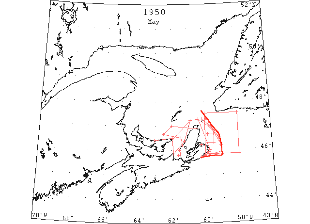
May Drift ice in Cabot Strait disappeared rapidly in May and on 16 May all routes to the Gulf of St. Lawrence were reported clear for navigation and reports by the Canadian Department of Commerce were discontinued. (IIP, P10)
May 1 10 miles west of St. Paul to 46°40’N 59°10’W to 45°50’N 59°00’W. Estimated outside limits widely scattered field ice. (IIP, P40 #846)
May 1 DOT aerial survey: Ice extends along E coast of Cape Breton from 10 miles W of St. Pauls to Scatari but is open and scattered between Flat Point and Scatari. (CIS IC1021_7)
May 1 DOT aerial survey: Over steamer track 10 miles off Cape Ray to 10 off Bird Rocks to Fame Point no ice reported. (CIS IC0790_9)
May 2 From St. Paul to 47°00’N 59°40’W to 30 miles off Flint Island. Outside limits field ice. (IIP, P41 #858).
May 3 From 10 miles east of St. Paul to 46°30’N 59°10’W to 44°50’N 59°00’W. Estimated outside limits field ice. (IIP, P41 #860). Moving SE. (CIS IC1013_11)
May 3 DOT aerial survey: Outside limits on W coast from Cape George to East point to 15 miles off Cape St. Lawrence. (CIS IC0988_2)
May 3 DOT aerial survey: except for ice in NE area of gulf the only ice liable to hinder navigation is located on the coast of Cape Breton and PEI, from Strait of Canso northward to Cape St. Lawrence to Cape North. (CIS IC0742_13)
May 3 DOT aerial survey: Strip along N coast of PEI about 10 miles wide westward from East Point to vicinity of Tracadie. This ice is close packed. Magdalen Islands clear. (CIS IC0828_5)
May 5 St. Paul to 46°30’N 59°10’W to 45°55’N 59°00’W to vicinity Forchu. Outside limits of field ice. (IIP, P41 #882).
May 5 DOT aerial survey: Sydney harbour clear, ice in approaches. (CIS IC1024_4)
May 5 DOT aerial survey: Louisburg ice is 3 miles off shore extending from Port Nova to 5 miles off Guion Island harbour and western approaches clear. (CIC IC1083_5)
May 5 DOT aerial survey: Strip of loose ice about 10 miles wide on N coast of PEI from East Point to vicinity of Tracadie, also belt surrounding island of Cape Breton except for 40 mile stretch between Chedabucto Bay and Guion Island. Outer limits from Cape George to East Point, PEI to 15 miles off Cape St. Lawrence to St. Pauls to 46°30’N 59°10’W to 45°50’N 59°00’W to vicinity of Forchu. Ice is for most part close packed on W coast, open and close packed on the E. (CIS 0742_13-IC0742_14)
May 6 DOT aerial survey: Ice is close on shore from Port Nova, westward to Forchu. (CIS IC1083_5)
May 7 45°50’N 58°00’W to 45°50’N 60°00’W. Scattered patches of strings and isolated heavy pieces. (IIP, P42 #961).
May 7 DOT aerial survey: Scattered patches and strings and isolated heavy pieces may be met anywhere between lats. 45°50’N and 47°30’N and lons. 58°00’W and 60°00’W. (CIS IC0913_7)
May 7 DOT aerial survey: E and S coasts of Cape Breton clear. Sydney harbour clear. (CIS IC1021_7&IC1024_4)
May 7 DOT aerial survey: Louisburg harbour clear. (CIS IC1083_5)
May 7 DOT aerial survey: Strong southerly and westerly winds and gales have broken up ice fields lately located on Cape Breton and PEI coasts and scattered ice over a wide area and NE of Cape Breton leaving one large field on NW coast of Cape Breton from 5 miles N of Mabou to 46°31’N 61°26’W to 46°40’N 62°30’W to 47°00’N 62°00’W to Cape North and a narrow string 1 or 2 miles wide from 10 miles S of Henry Island to Port Hood. (CIS IC0742_14)
May 8 58°00’W. Eastern limit widely scattered strings and isolated heavy pieces. (IIP, P42 #970).
May 8 DOT aerial survey: Narrow strip along shore between Judique and Port Hood may bring scattered ice in Strait of Canso. (CIS IC0958_4)
May 8 DOT aerial survey: Southward from Cape North ice has blown off the coast and widely scattered strings and isolated heavy pieces may be met to the 58th meridian. (CIS IC1021_7)
May 10 46°18’N to 46°40’N and 59°29’W to 59°50’W. Widely scattered pieces. (IIP, P42 #988). Isolated heavy pieces may be met to the 58th meridian. (CIS IC1013_11)
May 11 47°01’N 59°36’W. Heavy patches of drift ice stretching east and northward. (IIP, P43 #1011).
May 11 47°09’N 59°59’W. Strings heavy drift ice in south and westerly direction. (IIP, P43 #1012).
May 13 DOT aerial survey: Scattered strings and isolated heavy pieces may be met between last 46° and 47° and lons 59° and 60°. (CIS IC1013_11)
May 13 DOT aerial survey: Ice has moved off E coast of Cape Breton and Sydney excepted to remain clear. (CIS IC1021_7)
May 13 Last DOT flight of the season. (Pat 27 Apr 1959 p3 c2)
May 16 DOT aerial survey: Except for ice in NE area of gulf and Straits of Belle Isle all routes to River and Gulf are now clear for navigation. (CIS IC0742_14)
Jun 13 First Westbound steamer through the strait of Belle Isle. (WBB)
Jul 24 Gulf of St. Lawrence. No ice south of 51°30’N. (IIP, P57).