1947 Season
Dec 5 Last eastbound steamer through the Strait of Belle Isle. (WBB)
Dec 23 Last departure of the season from Quebec. (WBB)
Dec 23 SS “North Coaster” and the “Meigle” have arrived in port for the last trip of season. An oil tanker is expected tomorrow. (Pat 23 Dec p5 c3)
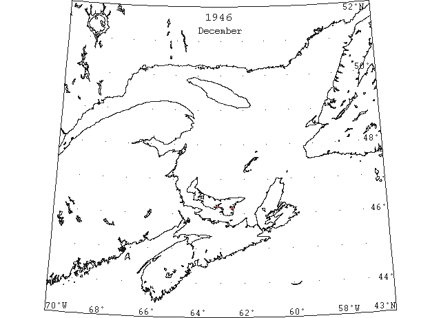
Dec 31 Georgetown – SS “Ulna” arrived in port on Monday (Dec. 31/46). The ferry boat to Montague is making regular trips although ice has formed in the harbour. (Pat 3 Jan 1947, p8 c4)
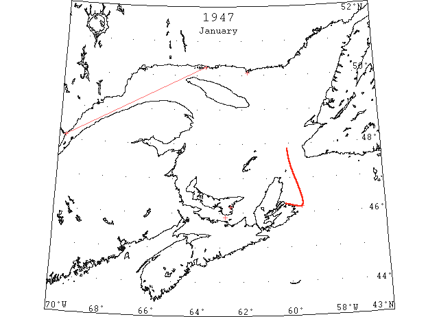
Jan No reports were received during January of the limits or movement of the field ice from the Gulf of St. Lawrence outward through Cabot Strait, but on the basis of the first aerial observation of the area on the 4th February, it is considered probable that the field had emerged through Cabot Strait soon after mid-January and had spread southeastward to the latitude of Flint Island by the end of the month. (IIP p6)
Jan 2 Ice breaker “Saurel” had reached the ice bound village of Natashquan – on the north shore of the Gulf of St. Lawrence yesterday morning. (Pat 3 Jan p5 c6)
Jan 7 Quebec – The ice breaker “Ernest La Pointe” sailed from here this morning to smash through ice fields to get supplies to the villages isolated along the north shore of the Gulf of St. Lawrence stretching from the estuary of the Saguenay to Havre St. Pierre, some 350 miles downstream from Quebec. (Pat 8 Jan p1 c1)
Jan 8 Ferry “Prince Edward Island” was held up by heavy ice on her 4:15 trip from Tormentine yesterday. (Pat 9 Jan p5 c4)
Jan 9 Georgetown – Montague ferry boat completed her service for the season on January 9th. (Pat 16 Jan p6 c7)
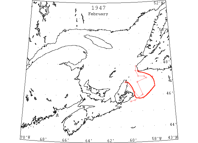
Feb The first available information was that obtained by aerial reconnaissance on the 4th. At that time the field emerging through Cabot Strait extended from Cape North to within 5 miles of the Newfoundland coast at Cape Ray and spread eastward past Burgeo Bank and southeastward almost to 44°50’N between 58°50’W and 59°12’W. Routes to Louisburg were free of ice and navigation apparently was possible to Sydney by rounding the southern edge of the field since a shore lead 10 to 15 miles wide was present along the coast as far as Cape North. No further information was obtained until the 21st when the area was again observed by aerial reconnaissance. The eastern limits of the field had receded 40 to 50 miles westward from those limits observed on the 4th, but the ice was now tightly packed along the beach northwest of Scatari Island and a tongue of slob ice diminishing to slush reached southwestward past Cape Breton to Guion Island, blocked the direct approaches to Louisburg. The inner and southern portion of this tongue, however, was so light as be no serious hazard to shipping and routes to Louisburg from the S or SE were considered to be navigable. While the plane was over the area a small freighter outbound from Louisburg was observed negotiating the inner portion of the tongue without apparent difficulty. The ice along the shore W of Flint Island was heavy and closely packed making access to ports W of that point impossible except for heavy ice-breaking vessels. The remainder of the field outward of Cabot Strait was lighter and more open. Scattered strings and patches extended to within 10 miles of the approaches to Port Aux Basques but the edge of the main field cleared the beach past Cape Ray, thence closing to within 3 to 5 miles of Cape Anguille. No further information was obtained during February. The next satisfactory coverage was obtained on the 13th and 14th March. The conditions observed at that time indicated that the field of ice outside Cabot Strait had probably continued to disintegrate and recede during the latter part of February, but that Sydney and other parts of Cape Breton Island W of Flint Island were inaccessible during the remainder of February and early March. The S coast of Newfoundland remained clear and the shore lead past Cape Anguille along the W coast of Newfoundland probably widened. (IIP p8-9)
Feb 4 From Cape Ray to Burgeo Bank to 46°35’N 57°45’W to 45°50’N 58°53’W to 45°50’N 59°13’W to 5 miles northeast of Flint Island, thence shore lead 5 to 10 miles wide closing to beach at Cape North. Outer limits field ice. Pans up to 100 yards in diameter. Coverage 10/10 in Cabot Strait decreasing to 7/10 eastward of 59 W. (IIP p33)
Feb 8 New England ice reported in Upper Chesapeake Bay, Potomac River and Tangier Sound. (HB #2997 Feb 15)
Feb 21 From 47°37’N 59°30’ W to 47°15’N 59°16’W to 47°14’N 58°43’W to 47°07’N 58°30’W to 46°52’N 59°22’W to 46°03’N 58°55’W to 45°42’N 59°40’W to 45°38’N 60°03’W. Eastern limit of St. Lawrence ice: Outer edge of ice is light and has many leads. Inner edge extends northerly with lead to Cape Breton. Closely packed bed of field ice 8 miles wide extends along beach northwestward of Scatari Island. (IIP p34#28)
Feb 21 The IIP #28 report should start 2 miles off beach at Cape Anguille. Also, ice SE of Cape Breton and E of 59°20’W is lighter and more open, becoming scattered at outer edge. (HB #2999 Mar 1)
Feb 26 Heavy drift ice in Chesapeake Bay, reported as improving. (HB #3000 Mar 8)
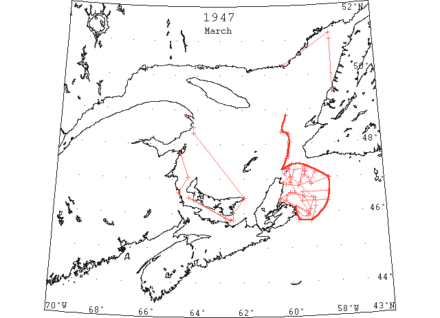
Mar In the St. Lawrence area the limits of the ice field continued to recede during early March but information concerning the change in the ice is very limited. On a flight on the 13th, the northeastern part of the gulf between Newfoundland and Quebec, little ice remained. The eastern half of this passage was entirely clear and the western half, outside of a narrow belt of fast ice along the shore, was about 5/10 to 7/10 cover of broken sheet ice, none of which appeared to be very heavy and evidence of rafting could be noted. The outer edge curved westward out of sight at a point 45 miles S of Cormorant Rocks. The area S and SE of Anticosti Island apparently was covered by field ice, the eastern edge of this field approaching to within about 40 miles of the Newfoundland coast west-northwest of Cape St. George thence curving westward. The edge curved eastward again to a point about 30 miles NW of Cape Anguille, then southward clearing Cape Anguille and Cape Ray by 30 miles, thence the edge again curved westward out of sight at a point about 7 miles W of St. Paul Island. Another closely packed field stretched southward from Cape St. Lawrence along the W coast of Cape Breton Island. A few broken strings were scattered in the area between St Paul Island and Cape North and scattered strings and patches could be seen to the limit of visibility SE along the Cape Breton coast.
The character and limits of this ice were better determined by an observation flight on the 14th covering the coastal area from Scatari Island to St. Paul Island. Closely packed ice was found to be close on shore in the bight between Scatari and Flint Islands and from Flint Island westward past Giboux Island this ice extended up to 12 miles seaward, blocking the approaches to Sydney. It is interesting to note that later this day the SS “Kyle” and SS “Caribou” which had been icebound at North Sydney, were able to get out through this ice. Strings and patches with a total cover of less than 1/10 were scattered up to 20 miles offshore from Scatari Island northward. The outer limit being approximately on a line from a point about 18 miles E of Scatari Island to St. Paul Island. The southeastern corner of that field stretching to the NW of St. Paul Island extended up to 10 miles farther E than the limits observed on the preceding day, and though no further reconnaissance but ice-patrol aircraft was carried out in this area, subsequent reports from naval air transport planes crossing from Sydney to Argentia indicate that this drift continued during March.
The NAT plane crossing the area on the 18th reported that the ice along the beach at Sydney was moving seaward leaving a shore lead inside Scatari Island and from Sydney westward. Subsequent reports indicate further scattering of ice that had been along the beach from Scatari Island past Sydney with some strings and patches reaching as far as 25 or 30 miles SE of Scatari Island and up to 60 miles or more E of that island. Other patches were moving out of the Cabot Strait and on the 29th the outer edge of an extensive field was reported extending from Cape North southeastward to the latitude of Cape Egmont and eastward to a point about midway between St. Paul Island and Burgeo Bank. At no time during the month did the ice menace the shipping routes inside of Sable Island nor block any of the ports south of Scatari Island. The S coast of Newfoundland was clear and a shore lead past Capes Ray and Anguille probably was present throughout the month. The Strait of Belle Isle, which had cleared to less than 5/10 cover in mid-March, was reported to be blocked on the 31st by ice moving southward along the Labrador coast. (IIP p12-14)
Mar 2 From 47°00’N 59°13’W to 47°06’N 59°23’W to 47°12’N 59°21’W to 47°20’N 59°23’W. Northern edge of field ice observed. Eastward of this edge strings and patches extended along latitude 47°20’ as far as 59°15’W, thence toward Burgeo Bank. (IIP p34#35)
Mar 10 All channels in Upper Chesapeake Bay clear of ice, broken drift ice along shores of Elk River. (HB #3002 Mar 22)
Mar 13 48°50’N 60°06’W. Eastern edge of sludge, the edge curved westward out of sight within 10 miles latitude north and south of this position. (IIP p34#45).
Mar 13 From 48°21’N 60°19’W to 48°17’N 60°00’W to 47°35’N 60°08’W to 47°15’N 60°20’W. Field of sludge ice to the westward of these points from last position trend was westward to limit of visibility. From 47°39’N 60°02’W to 48°03’N 59°57’W. Three small strings all near a … between these points. (IIP p34#46)
Mar 13 Ice Patrol plane: Quebec coast between 58°W and 60°W, scattered strings and patches of winter and sludge ice in belt 30 miles wide. Few isolated strings between 49°30’N and 51°N. (IIP_50)
Mar 14 From 47°17’N 60°06’W to 47°24’N 59°57’W. Eastern edge of field ice 9/10 cover. From 46°25’N 60°27’W to 46°29’N 60°00’W to Scatari Island. Outer limit belt of sludge 9/10 cover. From Scatari Island to 45°56’N 59°28’W to 46°02’N 59°17’W to 47°08’N 60°15’W. Widely scattered strings of sludge inside a line from these points to the outer limit of belt of sludge listed above. (IIP p35#52)
Mar 18 Beach at approx. 46°15’N 60°05’W to 46°22’N 60°12’W to 46°30’N 60°10’W to 46°36’N 60°00’W to 46°35’N 59°50’W to 46°28’N 59°27’W to 46°06’N 59°10’W to 45°57’N 59°15’W to Flint Island. Outer limits St. Lawrence ice. (IIP p35#55)
Mar 20 DOT aerial survey: From Pictou Island westward throughout Northumberland Strait drift ice with lakes of open water. Entrance to Charlottetown clear. (CIS IC0935_2)
Mar 20 DOT aerial survey: from East Point, PEI to Cape Bear to 3 miles E of Pictou Island, clear water. (CIS IC0978)
Mar 20 DOT aerial survey: From West Point, PEI to North Point, PEI ice extends off shore from 10 to 20 miles touching shore at Shippigan Island. Large lake of open water approximately 30 miles wide and 35 miles long off Bonaventure Island. (CIS IC0779)
Mar 21 From Scatari Island to 45°46’N 59°10’W to 46°10’N 58°57’W to 46°25’N 58°59’W to 46°35’N 60°00’W to beach at approx. 46°25’N 60°25’W. Outer limits of belt of sludge ice. From 46°50’N 59°07’W to 47°00’N 58°21’W. Narrow string of sludge ten miles on either side of line drawn between these points. From 47°13’N 59°22’W to 46°52’N 59°35’W to 47°15’N 59°28’W 47°15’N 59°50’W to 46°52’N 60°00’W to 47°18’N 60°03’W. Patch of sludge. (IIP p36#62)
Mar 25 From beach at approx. 46°53’N 60°20’W to 47°03’N 59°59’W to 46°25’N 59°02’W to 45°55’N 59°18’W to 45°48’N 59°43’W. Outer limits of slush and sludge. A 15-mile shore lead from beach at approximately 46°39’N 60°20’W southward. (IIP p36#64)
Mar 25 DOT aerial survey: From Pictou to Cape Egmont, PEI, N side of Strait clear, S side heavy drift ice. N entrance of Northumberland Strait blocked with heavy sheet and drift ice extending west to New Brunswick coast to 10 miles S of Bonaventure Island. (CIS IC0935_2-IC0935_3)
Mar 25 DOT aerial survey: Gaspe Bay full. (CIS IC0766)
Mar 29 Beach at Cape North to 46°50’N 60°10’W to 46°47’N 59°40’W to 46°53’N 59°10’W to 47°10’N 58°57’W. Field of ice approximately 10/10 cover. From 46°20’N to 46°36’N between 58°25’W and 59°30’W. Detached field of loose broken ice. Along 46th parallel between 57°30’W and 58°50’W. Loose scattered strings of ice. (IIP p36#69)
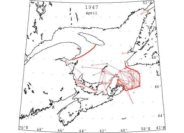
Apr The ice that emerged from the Gulf of St. Lawrence through Cabot Strait during the latter part of Mar. had covered the area off the north coast of Cape Breton Island as far south as Scatari Island by the 1st Apr. Reports of the seaward extent varied considerably, but the outer limits of this field were apparently comparatively constant during the first half of Apr. The average southerly limit was reported on the 6th about 40 miles east-southeast of Scatari Island and an extreme northeasterly limit about 10 miles southwest of Burgeo Bank was reported on the 8th. All reports during this interval indicated a shore lead 5 to 10 miles wide along the coast as far north as Cape Smoke. Following the 15th, the shape and extent of the field was apparently less static. The ice was becoming more broken and was being shifted offshore or onshore by changing winds. The field was sometime scattered over a wide area, but the scattering accelerated the weathering of the ice and the ice receded rapidly following 22 Apr until little or no ice remained in the area at the end of the month. At no time during the month had the ice extended along the coast south of Sactari Island nor had it endangered North Atlantic Track Agreement track “E”. Sydney was accessible to ice-worthy vessels most of the month by use of the shore lead from Scatari Island inward or by direct approach through the scattered patches forming the field ice during the latter part of the month.
The ice in the George-Northumberland Strait area was exceptionally light. A Swedish motor vessel was reported reached Georgetown Harbor, PEI, during the first week of Apr., which according to the news release, was the earliest date on record for a successful passage via the Gut of Canso and George Bay.
The St. Lawrence River also began to open at an early date. Local navigation was possible in some of the lower sections of the river as early as 4 Apr. A track of clear water 15 miles wide extended from St. Pauls Island to Bird Rocks to Fame Point to Quebec was reported to be so open as to be considered navigable. The first sea-going ship was reported to have arrived in Quebec on 20 Apr. On 26 Apr. the routes through the Gut of Canso to the St. Lawrence River via East Point or West Point, PEI, were reported open for navigation. At that time only a few broken fields or patches remained in the gulf and these were mostly in the eastern part. By the first of May, the only remaining patches of consequence were along the northeastern part of the gulf between NF and the mainland. (IIP p19-20)
Apr 1 From 5 miles off Cape Anguille to 15 miles off Cape Ray to St. Paul Island. Eastern limit of ice field. (IIP p37#73)
Apr 1 Off east coast Cape Breton Island. Field ice (outer limits not given). Shore lead 5 to 10 miles wide from Cape North to Sydney. (IIP p37#74)
Apr 1 From north to 46°50’N 59°10’W to 46°32’N 58°53’W to 46°00’N 58°56’W to 46°07’N 59°30’W thence to Cape Egmont. Limits of field ice (approximate). Shore lead 10 to 15 miles wide north to Cape Egmont. (IIP p37#75)
Apr 1 DOT aerial survey: E coast of PEI to Cape Bear clear, Georgetown harbour clear. (CIS IC0978)
Apr 2 From 8 miles off Cape Ray to 47°08’N 58°20’W to 46°30’N 58°20’W to 46°10’N 58°20’W. Eastern edge open field ice. Approaches to Sydney clear from southward. (IIP p37#76)
Apr 2 USCG Plane: Field ice southern shore of Strait of Belle Isle extending from Belle Isle to 51°20’N 56°50’W to 51°21’N 57°10’W to 51°07’N 57°32’W to beach at approximately 51°15’N 56°47’W. In Strait of Belle Isle from 57°W to Belle Isle 13 bergs and 6 growlers. (IIP p51)
Apr 4 20 miles off Cape Ray. Edge of field ice. Along east coast Cape Breton Island from Cape North to Scatari Island. Field ice. (IIP p37#80)
Apr 4 DOT aerial survey: From Woods Island westward to West Point, large fields of heavy ice moving E. (CIS IC0935_3)
Apr 4 DOT aerial survey: Cape North to Entry Island, Magdalens to 5 miles off East Point, PEI to Henry Island, heavy close packed ice. (CIS IC0823)
Apr 6 46°30’N 58°20’W. Eastern limit field ice. 45°43’N 58°50’W. Southern limit field ice. (IIP p37#81)
Apr 7 Scatari Island. Ice packed on Scatari Island and moving in on south coast Cape Breton. (IIP p37#82)
Apr 7 DOT aerial survey: N side of Northumberland Strait from Bell River to West Point heavy drift ice with scattered strings extending from Bell River eastward to Cape George. (CIS IC0935_3)
Apr 7 DOT aerial survey: Close packed ice extends northward off W coast of Cape Breton from Henry Island to Cape North. (CIS IC0982)
Apr 7 DOT aerial survey: Gaspe solid. (CIS IC0766)
Apr 8 47°00’N 59°05’W to 46°30’N 58°40’W to 46°20’N 58°40’W to 46°05’N 58°57’W to 46°32’N 60°10’W. Outer limits field ice. (IIP p37#83)
Apr 8 47°00’N 58°10’W. Eastern limit field ice. 46°10’N 58°20’W. Southern limit field ice. Ice extends down east coast Cape Breton Island to Scatari and is close on shore at White Point. (IIP p37#84)
Apr 8 DOT aerial survey: Pictou Island to Point Prim scattered strings; Point Prim to West Point heavy ice. (CIS IC0935_3)
Apr 8 DOT aerial survey: Pleasant Bay clear. (CIS IC0824)
Apr 9 Across mouth of St. George’s Bay. Occasional strings sludge. 20 miles west of Cape St. George. Tongue of field ice (apparently main pack with strings navigable ice extending eastward to Cape St. George. (IIP p38#94)
Apr 9 From northwest to 47°00’N 59°05’W to 46°20’N 58°40’W. Eastern edge field ice. 46th parallel. Southern limit field ice. From beach at Ingonish Island to 2 miles off Flint Island. Inner edge of field ice. (IIP p38#95)
Apr 10 46°05’N 59°00’W to 46°20’N 58°40’W to 47°00’N 59°05’W. Eastern limit of field ice. 46th parallel. Southern limit of field ice. (IIP p39#107)
Apr 10 DOT aerial survey: N entrance to Northumberland Strait closed. (CIS IC0935_3)
Apr 10 DOT aerial survey: S of a line from 47°41’N 63°00’W to Brion Island to St. Pauls to Cape North ice extends to N coast of PEI and W coast of Cape Breton, and is about 65% covered. (CIS IC0811)
Apr 11 70° 23 miles off St. Paul’s to 46°20’N 58°10’W. Eastern limit of field ice. 46th parallel. Southern limit of field ice. (IIP p39#108)
Apr 11 DOT aerial survey: Pictou harbour and approaches clear. (CIS IC0935_3)
Apr 13 25 miles off Cape Ray to 46°20’N 58°10’W. Eastern limit of field ice. 46th parallel. Southern limit of field ice. (IIP p39#109)
Apr 14 Along east coast Cape Breton Island from Cape North to Cape Pine [?] trending southeast 15 miles off Scatari Island. Loose field ice. 46th parallel. Southern limit of field ice. (IIP p39#110)
Apr 14 Georgetown – loaded first steamer of the year which left yesterday for England. (Pat 15 Apr p10 c3)
Apr 15 DOT aerial survey: Westward in Northumberland Strait loose open ice scattered at Summerside and Tormentine. (CIS IC0935_4)
Apr 16 From 25 miles off Cape Ray to 47°10’N 58°30’W south to line east true from Flint Island. Outer limit of field ice. This area very open and navigable with caution. (IIP p39#111)
Apr 16 DOT aerial survey: Loose drift ice from Cape Tormentine to 10 miles W of Cape Egmont. W of Cape Egmont, PEI, large patches and strings drifting from Bay of Chaleur, navigable today. (CIS IC0935_4)
Apr 16 DOT aerial survey: Magdalens report Pleasant Bay and Old Harry clear, with ice at all other points. (CIS IC0824)
Apr 16 CGS “Brant arrived in port yesterday (Charlottetown). (Pat 17 Apr p5 c3)
Apr 17 47°02’N 58°45’W to 46°30’N 58°45’W to 46°07’N 59°00’W. Eastern limit of field ice. 46th parallel. Southern limit of field ice. (IIP p39#118)
Apr 17 DOT aerial survey: Magdalens report Amherst ice about 10 miles off shore, all other points clear. (CIS IC0824)
Apr 18 47°16’N 59°03’W to 46°30’N 58°45’W to 46°07’N 59°00’W thence south to line east true from Flint Island. Outer limits field ice. 10 mile shore lead from Scatari Island to Cape North. (IIP p39#119)
Apr 18 DOT aerial survey: Main body of ice today is located S of a line from 30 miles off North Point, PEI to Magdalens to Cape North, extending southward to N coast of PEI and along W coast of Cape Breton to Sight Point. (CIS IC0824)
Apr 18 First arrival of season at Quebec. (WBB)
Apr 18 First cargo carrying vessel to sail out of Charlottetown Harbour this season for St. John’s, Newfoundland will leave today. (Pat 18 Apr p8 c3)
Apr 19 47°20’N 58°50’W to 46°30’N 58°40’W thence south to line east true from Flat Point [Flint Is?]. Outer limits of field ice. Shore lead 10-15 miles wide from Flat Point to Cape North. (IIP p40#143)
Apr 19 DOT aerial survey: Northumberland Strait clear from East Point to West Point with exception of small body of close packed ice between Cape Egmont and West Point. (CIS IC0935_4)
Apr 20 From St. Paul’s to 46°30’N 59°10’W to Ingonish Island. Outer limits ice off east coast to Cape Breton Island. (IIP p40#144)
Apr 20 DOT aerial survey: Gaspe open to ½ miles from harbour. (CIS IC0766)
Apr 20 DOT aerial survey: S of a line from 47°00’N 62°50’W to Amherst Island to Cape North ice extends to 5 miles off East Point and along W coast of Cape Breton to Margaree. (CIS IC0825)
Apr 21 From St. Paul’s Island to 47°00’N 59°00’W to 46°30’N 58°50’W to 46°20’N 59°30’W to Cape Egmont. Outer limits field ice. Shore lead 10 miles wide from Scatari Island to Cape Smoke. (IIP p40#145)
Apr 21 DOT aerial survey: W coast of Cape Breton clear to 5 miles S of Cheticanp. (CIS IC0982)
Apr 22 From 5 miles off Cape North to 46°10’N 58°10W south to 10 miles east of Scatari to 5 miles off Flat Point to Cape Smoke. Outer limits field ice. (IIP p40#146)
Apr 22 DOT aerial survey: [Northumberland] Strait clear except for patch of ice E of Egmont Bay. (CIS IC0935_4)
Apr 22 DOT aerial survey: Area within the following lines, from 15 miles W of East Point, PEI to Amherst Island, Magdalens to Cape North, to Seawolf Island to 3 miles S of East Point, PEI, open and close packed ice. (CIS IC0825)
Apr 23 From 5 miles south of St. Paul’s to 45°00’N 59°00’W to 3 miles off Scatari Island to 3 miles off Flint Island to 5 miles off Flat Point to St. Ann’s. Limits of field ice. (IIP p41#143)
Apr 24 DOT aerial survey: Cheticamp, ice off shore is moving east. (CIS IC0982)
Apr 24 DOT aerial survey: Northward from West Point to Cap des Rosiers some scattered patches between North Point, PEI and Bay of Chaleur. (CIS IC0779)
Apr 24 DOT aerial survey: At East Point, scattered drift ice in gulf, strait clear. (CIS IC0825)
Apr 25 From St. Paul’s to 47°10’N 59°20’W to 46°20’N 59°20’W. Eastern edge field ice. Shore lead 10 miles wide from Scatari Island to Cape North. (IIP p41#191)
Apr 25 DOT aerial survey: Northumberland Strait clear, and route via West Point and East Point navigable to Cape des Rosiers. (CIS IC0935_4)
Apr 25 DOT aerial survey: Southern limits of ice between East Point, PEI and Cape Breton from 12 miles off East Point to 15 miles off Sea Wolf Island to 5 miles off Cheticamp taking coast at Cape St. Lawrence. Western limits of this ice from 12 miles of East Point to Entry Island, Magdalens. (CIS IC0825)
Apr 26 From St. Paul’s to 46°40’N 59°00’W thence south to 46 N to Scatari Island. Outer limits field ice. (IIP p42#198)
Apr 27 8 miles north of Cape Ray light. Small berg. (IIP p42#199)
Apr 27 DOT aerial survey: Gaspe still holding. (CIS IC0766)
Apr 28 East coast of Cape Breton Island. Clear of ice except few scattered strings. (IIP p42#225)
Apr 29 Breton Island south of Aspy Bay. Clear of ice except for few scattered strings. (IIP p42#226)
Apr 29 DOT aerial survey: Extensive field on N coast of Cape Breton from 10 miles N of Cheticamp around Cape North. (CIS IC0982)
Apr 30 48°51’N 58°53’W. Small berg. (IIP p43#227)
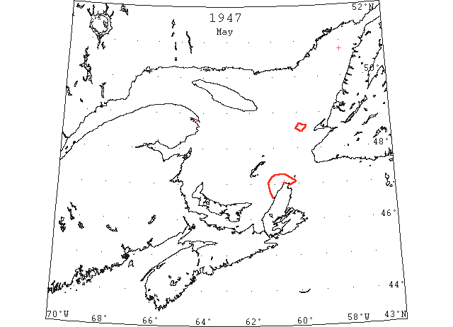
May 1 River and Gulf of St. Lawrence. Now clear for navigation to river ports via Bird Rocks and Fame Point and from Strait of Canso via East and West Points Prince Edward Island. Also clear to ports on west coast Cape Breton Island, Prince Edward Island, Magdalens, and New Brunswick. Northeast part of gulf, North coast of Cape Breton Island vicinity Cape St. Lawrence. Only areas where ice of consequence remains. (IIP p43#236)
May 1 DOT aerial survey: Gaspe breaking up but not sufficiently clear of ice for ships to enter. (CIS IC0766)
May 5 DOT aerial survey: Gaspe approaches breaking up, ice still in harbour. (CIS IC0766)
May 7 Last DOT flight of the season. (Pat 27 Apr 1959 p3 c2)
May 21 First Westbound steamer through the strait of Belle Isle. (WBB)