1942 Season
Normally, navigation may be expected to open up across the Gulf of St. Lawrence to the mouth of the St. Lawrence River about mid-April, the route becoming ice free prior to 10 May. In 1942 the ice in the central gulf broke up rapidly between 29 March and 4 April. On the latter date the shipping track from Cape Ray to Fame Point was navigable and the ice broken to Quebec. The next day the Cape Ray to Fame Point track was clear. Ice persisted S of Anticosti Island, and in the southern part of the gulf in the vicinity of PEI until early May. From time to time during April occasional patches of this ice drifted across the shipping track between Fame Point and Cape Ray but did not close it. On 22 April the St. Lawrence River was open to Montreal. On 6 May all gulf routes from the S were sufficiently clear of ice to permit discontinuing the ice surveys in that area. Excluding the northeastern section of the gulf near the Strait of Belle Isle, two bergs were reported.
On the banks SW of Nova Scotia and Cape Breton Island the southern extremity of the pack during March and April could usually be found between 44°30’N and 45°30’N. The ice never extended as far as Sable Island, and on only two occasions was there any threat of the ice forcing inshore traffic to the S of that island. The westerly extension of the ice stopped short of Halifax. Traffic E from that port was little inconvenienced by the ice and if so desired could always be routed S of the ice and N of Sable Island.
Light patches of ice were reported in the vicinity of Louisburg until 4 May, after which no more ice was reported S of the gulf. (IIP 1946 p1)
Nov 24 Last eastbound steamer through the Strait of Belle Isle. (WBB)
Dec 17 Reports reaching here state that Adies Lake had frozen over this year much ahead of schedule, so that teams are now able to cross the ice in delivering supplies to Camp 86. Adies Lake is 6 miles wide. (TWS, p.1).
Dec 24 Last departure of the season from Quebec. (WBB)
Dec 24-31 Georgetown – The SS “Ulna” carried another cargo of potatoes to Sydney last week. (Pat 5 Jan 1942 p8 c3)
Jan 13 Georgetown – ferry boat “Montague” made her last trip of the season on Tuesday (January 13th). The same date as last year (Ferry to Montague). (Pat 16 Jan p8 c5)
Jan 14 Two mail airplane trips to the Magdalene Islands. (means navigation is closed) (Pat 14 Jan p5 c3)
Jan 16 Ice warnings for New England coast and Chesapeake Bay which has ice 1 – 4 inches thick near Tolchester. (HB #2733 Jan 21)
Jan 16 The icebreaker “Fairview” made a round trip this forenoon; she returned this afternoon without much difficulty. Two foot passengers were walking along on the ice beside the boat (no info on location or where the vessel was going, “Fairview” was on the Charlottetown Harbour crossing). (Pat 16 Jan p5 c3)
Jan 16 Ferry “Fairview” made two trips to Rocky Point on Friday (January 16th). No further trips this season, closed one day later than last year. (Pat 21 Jan p5 c3)
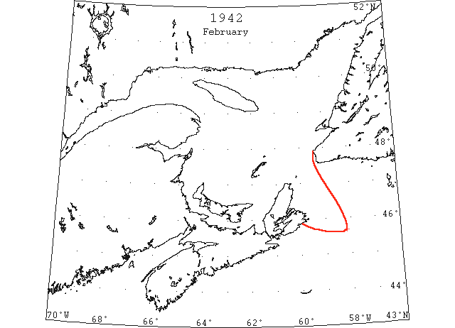
Feb 25 45°40’N 58°10’W heavy floes. (IIP 1946 p7)
Feb 25 45°40’N 58°10’W heavy floes of ice covering a large area. (NYMR)
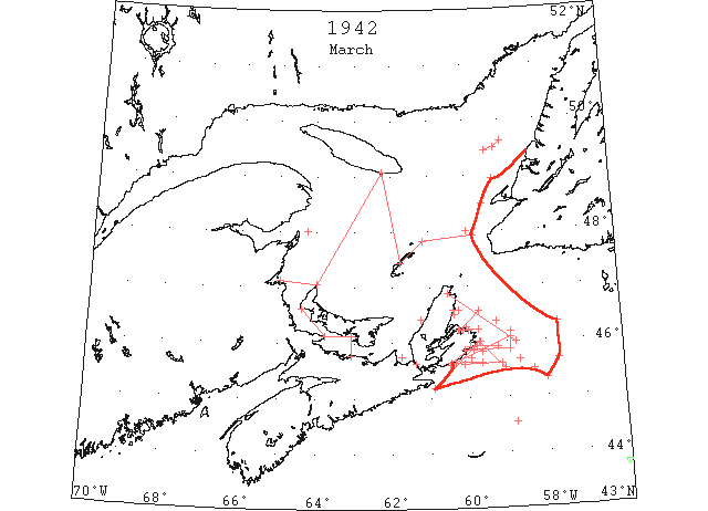
Mar 2 Cape Breton Island south to 45°20’N and east to 58°00’W. heavy field (IIP 1946 p7)
Mar 2 44°32’N 58°50’ drift area 2 miles long (IIP 1946 p7)
Mar 8 Cape Breton island field extends 50 miles south and east (IIP 1946 p7)
Mar 8 Sydney Harbour frozen. St. George Bay at March Point clear. (IIP 1946 p7)
Mar 9 67°N 57°W open water north and south visibility limit. West of 67°00’N58°30’W heavy ice no open leads. Cumberland Peninsula (67°N 62°W) winter ice 5 miles off (IIP 1946 p7)
Mar 10 Cape Breton Island to Prince Edward Island. North of Prince Edward Island open channel then broken ice (IIP 1946 p7)
Mar 11 From 49°30’N 59°10’W outer edge bearing 045° and 250°loose patches to Cape Breton coast (IIP 1946 p7)
Sydney Harbor Arms frozen. North Sydney open water to sea (IIP 1946 p7)
Mar 14 46°20’N 57°40’W west [east?] edge of pack. Narrow strings heavy pans, 50 to 60 feet across, 60% coverage extended south 40 miles 45°50’N 59°39’ west edge pack. Chedabucto Bay narrow strings. Gut Canso closed (IIP 1946 p7)
Mar 16 Sydney arms frozen. North Sydney to sea drift (IIP 1946 p7)
Mar 16 Cape Breton to 45°30‘N to 58°20’W pack. Light ice on 10 miles east. North Sydney seawards close packed drift (IIP 1946 p7)
Mar 18 Gabarus Bay field extends 50 miles E then N to limit of visibility. Sydney arms frozen, drift to horizon. Forchu Bay ice 12 miles off. (IIP 1946 p7)
Mar 18 45°51’N 59°53’W scattered drift. (IIP 1946 p7)
Mar 20 15 miles south of Gabarus Bay field to 40 miles seaward. 45°40’N 58°42’W heavy drift (IIP 1946 p8)
Mar 21 Mouth St. George Bay large floes. In gulf floes heavy ice. 75 miles S of Cape Ray large area thin ice. (IIP 1946 p8)
Mar 21 Sydney west arm frozen, drift to horizon. Louisburg Harbor drift 8 miles off. 46°35’N 60°23’W field extends south and east (IIP 1946 p8)
Mar 22 St. Esprit drift ice 5 miles off east to limit visibility (IIP 1946 p8)
Mar 23 Sydney west arm frozen, drift to horizon. (IIP 1946 p8)
Mar 24 Sydney west arm frozen, scattered drift to horizon. Louisburg Harbor close packed drift to horizon (IIP 1946 p8)
Mar 25 46°05’N 58°55’W ice to coast 45°35’N 60°30’W ice ends Cape Breton coast Scatari to St. Esprit open and close pack. Also 40 miles southeast of Scatari (IIP 1946 p8)
Mar 26 Sydney west arm frozen, drift on horizon. Louisburg scattered drift ½ mile off. (IIP 1946 p8)
Mar 26 DOT aerial survey: From Scatari westward along coast to St. Esprit open and close pack ice. (CIS IC1080)
Mar 28 Sydney scattered ice 3 miles off shore to 20 miles off. (IIP 1946 p8)
Mar 29 Sydney arms frozen heavy drift to horizon. Louisburg Harbor close packed drift 7 miles off Berg, growlers 43°42’N 56°05’W (IIP 1946 p8)
Mar 29 Northumberland strait from Cape Tormentine to Hillsborough Bay open then close packed ice to horizon. Cape Tormentine to west point Prince Edward Island close packed on south. Strings 10 miles east Birch Point. Chaleur Bay north side open. Gaspe open to 3 miles Sandy Beach Light House. East of North point PEI to South point Anticosti open and close packed ice toward Magdalens and Bird Rocks to Anticosti to 47°55’N 59°50’W to 48°30’N 59°33’W. Then north along Newfoundland coast to visibility limit. Cape North to 40 miles east Scatari along east coast Cape Breton Island heavy closed packed. South of line Scatari to 45°10’ 60°55’ open and close pack (IIP 1946 p8)
Mar 29 Scatari Island, 2-mile string 4- to 5- foot–thick ice, 2 miles off, running north to south (IIP 1946 p8)
Mar 30 Sydney ice packing into harbor, extends 10 miles off and along coast (IIP 1946 p8)
Mar 30 DOT aerial survey: Bay of Chaleur open water as far as can be seen. (CIS IC0919)
Mar 30 DOT aerial survey: Northumberland Strait from Cape Tormentine eastward to Hillsborough Bay, open water then close packed ice as far as can be seen. From Cape Tormentine westward through strait to West Point, PEI, close packed on S side and extending northward to a line from Miramichi Bay to North Point, PEI. (CIS IC0937)
Mar 30 DOT aerial survey: Westward of a line from North Point, PEI to South Point, Anticosti, open water with exception of a small string 10 miles E of Birch Point. (CIS IC0780)
Mar 31 48°00’N 60°00’W floe of 60 square miles. Ice floes through middle gulf (IIP 1946 p8)
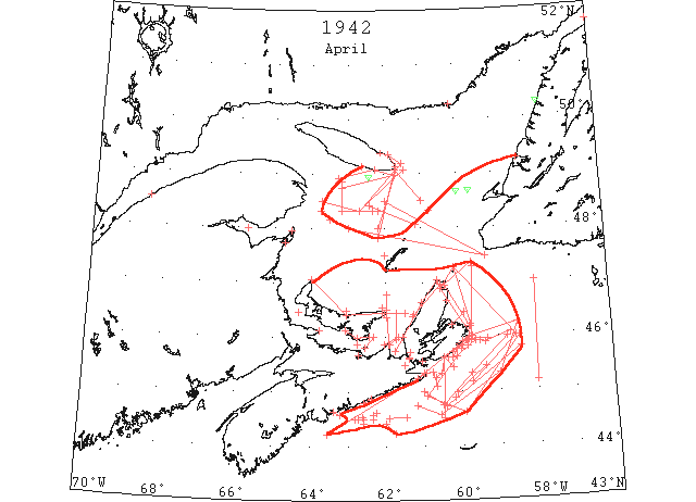
Apr 1 Sydney west arm frozen, arm packed drift. Heavy drift to horizon. 5 miles off Louisburg Harbor drift. Drift ice 30 miles south White Head. 10 miles off Greene Isle. 5 miles off St. Esprit. 5 miles off Guion Island (IIP 1946 p8)
Apr 2 Sydney same as 1 Apr. Louisburg light close pack drift shore to 3 miles (IIP 1946 p8)
Apr 2 Ice field north of 45°00’N 61°00’W, 44°44’N 60°26’W, 45°48’N 58°26’W (IIP 1946 p8)
Apr 2 Cape Breton to Madame Island broken pack and pancake extends off shore 20 to 50 miles, close packed
Apr 3 DOT aerial survey: Ice extends along S coast of Cape Breton and Nova Scotia to vicinity of County Harbour but is some distance off the coast from White Head westward; western edge running along 61st meridian and southern edge along northern edge of Middle Bank to 40 miles S of Scatari. (CIS IC0914 & 1090)
Apr 3 DOT aerial survey: Bay of Chaleur open to Maquereau Point. (CIS IC0919)
Apr 3 DOT aerial survey: Northumberland Strait clear. (CIS IC0937)
Apr 3 DOT aerial survey: Ice extends up W coast of Cape Breton from Port Hood to Cape North and southward along E coast. (CIS IC0997)
Apr 3 DOT aerial survey: From Father Point to 63rd meridian mostly clear water. (CIS IC0749)
Apr 3 DOT aerial survey: From 63rd meridian eastward over steamer track towards Cape Ray open and close packed ice at present not navigable. (CIS IC0794)
Apr 4 Above Quebec solid. Quebec to Father Point broken. Fame Point to 63°00’W mostly clear. Areas Northumberland Strait clear but still closed. George Bay ice loosening. West coast Cape Breton Island ice to Cape North. From 48°30’N 62°00’W to 10 miles south Cape Ray. Track Cape Ray to Frame Point navigable. To 40 miles south and east Scatari ice Artimon Bank strings and patches. West to Whitehead 20 miles off shore from Canso west. Louisburg and Sydney scattered ice to horizon. (IIP 1946 p8)
Apr 4 DOT aerial survey: Drift ice in Northumberland Strait from Cape Bear westward to Hillsborough Bay. (CIS IC0937)
Apr 4 DOT aerial survey: Ice extends westward along Cape Breton coast from Scatari to White Head but 20 miles off from Canso westward. (CIS IC1090)
Apr 4 DOT aerial survey: Narrow strip along shore of N side of PEI then open water for 8 miles in width then heavy open and close pack with large sheet to 47°30’N then clear water W of 62nd Meridian to Anticosti with a few scattered strips. (CIS IC0780)
Apr 4 DOT aerial survey: From 48°30’N 62°00’W over steamer track to Cape Ray open water; from 23 miles SW of Cape Ray ice extends southeastward and to Cape Breton coast. (CIS IC0840)
Apr 5 Sydney same as 1 Apr. Track Cape Ray to Fame Point clear. Pack from Cape Breton coast to 44°55’N 60°10’W thence edge trends 030° true. (IIP 1946 p8)
Apr 5 From 20 miles S true from White Head light ice extends in a southeasterly direction to 44°35’N 60°35’W to 45°19’N 59°00’W to 46°15’N 58°30’W and northwestward as far as can be seen and to the Cape Breton coast as Scatari and northward. (CIS IC0914)
Apr 5 DOT aerial survey: Bay of Chaleur navigable to New Carlisle with Aspe Bay open to 3 miles below Sandy Beach. (CIS IC0919)
Apr 5 DOT aerial survey: Large areas of Northumberland Strait clear but Strait not navigable at present. (CIS IC0937_2)
Apr 5 Ice is on the coast from Scatari westward to St. Esprit and 20 miles off Canso and White Head; this ice is fairly open from St. Esprit to Guion Island. This large body of ice is fairly open from Guion Island westward and southward from Louisburg consists of strings and patches with lakes of open water, loose ice in Louisburg. (CIS IC1090)
Apr 5 DOT aerial survey: From Cape Ray to Fame Point navigable at present. (CIS IC0794)
Apr 6 Sydney west arm frozen, south arm open. Drift to horizon. Louisburg packed drift to 6 miles off (IIP 1946 p8)
Apr 7 Shippigan full. Miscou, Pictou, drift outside. Elmira scattered drift in gulf (IIP 1946 p8)
Apr 7 Sydney same as Apr 6 (IIP 1946 p8)
Apr 7 45°21’N 60°45’W to 45°06’N 60°40’W heavy ice. 44°58’N 60°07’W, 45°27’N 59°22’W eastern edge. Northeastern and southeastern visibility limit. 45°54’N 59°22’W 30 mile wide belt 069° true (IIP p8)
Apr 8 Northumberland Strait closed. East point PEI scattered ice in gulf and strait. Cape North to St. Paul heavy ice. Also St. Paul to 50 miles east and south of Scatari, Middle Bank west to St. Esprit. Sydney same as 6 Apr. Heavy ice in Louisburg Harbor in all directions. (IIP 1946 p9)
Apr 8 DOT aerial survey: Bay of Chaleur is navigable to New Carlisle with broken ice in vicinity of Miscou and Shippigan. (CIS IC0919)
Apr 8 DOT aerial survey: Pictou harbour is open. (CIS IC0937_2)
Apr 8 DOT aerial survey: Ice at East Point, PEI loosening, only scattered drift ice visible in gulf and strait today but ice on horizon. (CIS IC0977)
Apr 8 DOT aerial survey: Louisburg light close pack extending S for 5 miles and E and W as far as can be seen. (CIS IC1080)
Apr 8 DOT aerial survey: From Scatari westward ice is close inshore to St. Esprit but is well off from there westward; ice off S coast of Cape Breton is loose and open. (CIS IC1090)
Apr 9 Artimon Bank to 47°N heavy pack ice in large pieces (IIP 1946 p9)
Apr 9 DOT aerial survey: Bay of Chaleur clear along N side to New Carlisle, some broken ice along S side; Shippigan Bay full. (CIS IC0919_2)
Apr 9 DOT aerial survey: Northumberland Strait drift ice on S side towards Pictou Island. (CIS IC0937_2)
Apr 9 DOT aerial survey: A large area of open water from East Point, PEI, and to the Cape Breton coast N of Port Hood to Seawolfe Island. (CIS IC0977)
Apr 9 DOT aerial survey: Very heavy close packed ice on W coast of Cape Breton from Seawolfe to 5 miles off Cape North trending eastward. (CIS IC0997)
Apr 9 DOT aerial survey: Father Point, Cape des Rosiers and over steamer track to Cape Ray practically clear. (CIS IC0794)
Apr 9 DOT aerial survey: Large field sighted southern limits 48°30’N 61°00’W. (CIS IC0840)
Apr 10 44°53’N 60°12’W extensive floe. Broken floes St. Paul Island to Sydney and seaward 20 miles. Clear track through gulf. Cape Breton Island west coast heavy pack. Heath Point large field to 48°30’N 61°00’W. Louisburg open (IIP 1946 p9)
Apr 10 DOT aerial survey: Limits of ice fields off Cape Breton coast as follows: N edge of ice from 25 miles S of Cranberry, Canso to 8 miles S of Guion Island to 7 miles SE of Scatari with large area of open water from Flint Island towards Sydney southern edge from 53 miles E of Scatari to 40 miles N of Sable Island to 25 miles S of Cranberry, Canso. This ice field is very open with leads and large lakes of open water. (CIS IC0914_2)
Apr 10 DOT aerial survey: No open water showing N and E from East Point, PEI, whilst S from East point, PEI, open water along E coast of PEI to Cape Bear. (CIS IC0977)
Apr 11 Sydney west arm frozen, south arm open to dockyard. Scattered drift to horizon. Cape Breton ice north edge 25 miles south Cranberry to 8 miles south Guion Island to 7 miles south-east Scatari. Area open water Flint Island to Sydney. Southern edge 53 miles east Scatari to 40 miles north Sable Island to 25 miles south Cranberry. Canso opening. Gulf no change. (IIP 1946 p9)
Apr 10[20?] DOT aerial survey: from Cap des Rosiers over usual steamer track ice may not be met east of 63rd meridian to Bird Rocks, Heath point reports heavy ice everywhere. Eastward from there to Cape Ray and S coast of Newfoundland clear. (CIS IC0794_2)
Apr 11 DOT aerial survey: Large areas in Northumberland Strait clear but not navigable throughout, Tormentine, Summerside and Pictou clear. (CIS IC0937_2)
Apr 12 Sydney as 11 Apr. Loose drift 3 miles off Louisburg extending all directions. Gut Canso, Northumberland Strait open ice. Flat Point close packed all sides. Cape Breton Island considerable ice both sides (IIP 1946 p9)
Apr 13 DOT aerial survey: Heavy close packed ice N and E of East Point, PEI, with 5 miles strip of open water along S side. (CIS IC0977)
Apr 13 DOT aerial survey: Heavy ice at Louisburg as far as can be seen from shore. (CIS IC1080)
Apr 14 51°42’N 56°00’W heavy pack Newfoundland almost to Labrador. 50°15’N 57°38’W berg. 49°15’N 58°18’W large patch loose ice. Loose ice 20 miles west and northwest of Gurney island (IIP 1946 p9)
Apr 14 Southern edge in Gulf 48°25’N 62°25’W to 15 miles north of Bird Rocks then northeast. Ice both sides Cape Breton Island. From 20 miles east St. Paul Island to southeastern Scatari to Whitehead and all sides Canso (IIP 1946 p9)
Apr 14 DOT aerial survey: Ice is close in on the coast also westward along S coast of Cape Breton to Whitehead. (CIS IC1080)
Apr 14 DOT aerial survey: Ice field with southern edge in 48°25’N 62°25’W extending to 15 miles N of Bird Rocks then trending northeastward, no ice at Cape Ray. (CIS IC0794)
Apr 15 PEI heavy packed to north. Anticosti to 48°25’N 62°25’W to 15 miles north Bird Rocks then northeast (IIP 1946 p9)
Apr 15 DOT aerial survey: Scattered ice all along shore as far as can be seen. (CIS IC1080)
Apr 16 Northumberland and Canso Straits drift ice (IIP 1946 p9)
Apr 16 DOT aerial survey: East point, PEI narrow strip of open water along shore in gulf and strait close packed off shore. (CIS IC0977_2)
Apr 17 DOT aerial survey: Light drift ice along S side of Northumberland Strait W of Tormentine, eastward fairly clear to Pictou, close packed ice from Pictou Island to 5 miles off Cape Bear. (CIS IC0937_3)
Apr 17 DOT aerial survey: Ice extends up S coast of Cape Breton and Nova Scotia to vicinity of County Harbour but is some distance off from Canso westward with ice visible from Canso to the N and stretching to the SE. (CIS IC1090_2)
Apr 17 DOT aerial survey: Large ice field with western edge in 48°52’N 63°10’W to 48°20’N 63°10’W and southern edge to 48°20’N 62°10’W then trending to the NE track from Cape de Rosiers. (CIS IC0749)
Apr 19 Sydney west arm partly open, south arm packed to limit visibility (IIP 1946 p9)
Apr 20 Pack ice 5 miles out of Louisburg thence St. Esprit thence 15 miles southeast (IIP 1946 p9)
Apr 20 Shippigan Bay full. Heath Point heavy close packed. Elmira heavy in gulf and strait. Strait Canso, Canso harbor drift ice (IIP 1946 p9)
Apr 20 DOT aerial survey: Bay of Chaleur open to Dalhousie with some ice in Shippigan Bay. (CIS IC0919_2)
Apr 20 DOT aerial survey: Northumberland Strait clearing, Escumiac and Summerside clear, some drift at Tormentine and off Pictou. (CIS IC0937_3)
Apr 20 DOT aerial survey: Heavy close packed in Gulf and Strait around East Point, PEI. (CIS IC0977_2)
Apr 20 DOT aerial survey: Ice extends up W coast of Cape Breton with heavy close packed in Gulf and Strait. (CIS IC0997)
Apr 20 DOT aerial survey: No ice in sight at Louisburg. (CIS IC1076)
Apr 21 Pack 3 miles off shore Louisburg to Cape Breton then 20 miles off shore (IIP 1946 p9)
Apr 21 8 miles loose ice 120° from Egg Island buoy. 44°25’N 62°00’W floe 15 miles seaward. 44°30’N 62°44’W pan ice 5 miles by 200 yards parallel to coast. 44°32’N 62°38’W loose cap ice 8 miles wide (IIP 1946 p9)
Apr 22 Navigable to Montreal. Elmira heavy close packed. Heath Point heavy broken. Strait Canso drift ice. Sydney Harbor full Aspy to Flint Island. Canso Harbor full 25 to 30 miles off Coast Spry Bay to Beaver Bay (IIP 1946 p9)
Apr 22 DOT aerial survey: Ice has moved off the W coast of Cape Breton, no ice at Cheticamp and Cape North. (CIS IC0997)
Apr 22 DOT aerial survey: No ice in sight at Scatari or Louisburg; some ice along S coast of Cape Breton, Canso harbour full. (CIS IC1080)
Apr 23 Gulf points as 22 Apr. Sydney both arms open. Close packed to horizon, 44°30’N 62°50’W loose ice 4 square miles. 44°37’N 62°15’W large areas loose ice. 44°35’N 62°20’W loose ice 10 by 5 miles. 44°30’N 62°20’W large area ice (IIP 1946 p9)
Apr 23 Halifax to Cape Breton 10 to 35 miles off coast light open strings (IIP 1946 p9)
Apr 23 44°30’N 62°36’W heavy broken field 5 miles to south. 44°31’N 61°55’W 090° true heavy broken field ice for 19 miles. (IIP 1946 p9)
Apr 23 DOT aerial survey: Ice 6 miles westward from Cape George along the coast to 5 miles westward of Port Hood. Narrow strip along S shore of Northumberland Strait from Tormentine westward. No ice from North Point, PEI to Malpeque Bay. (CIS IC0937_3)
Apr 23 DOT aerial survey: Narrow strip of ice across northern part from 5 miles W of Cape George to 5 miles W of Port Hood. (CIS IC0999)
Apr 23 DOT aerial survey: Ice along shore of S coast of Cape Breton from Union Island to Mainadieu Passage 25 miles in width. Large area of open water from SW edge towards Louisburg. (CIS IC1080)
Apr 23 DOT aerial survey: Large field with southern edge 48°10’N 63°30’W trending northeastward edge 48°20’N 63°45’W then trending northeastward; scattered pieces off the S and western edges. Occasional strings off entrance to Bay of Chaleur. (CIS IC0749)
Apr 23 DOT aerial survey: No ice between St. Pauls and Bird Rocks. (CIS IC0840)
Apr 24 Berg southeast Fame point. Heath Point heavy broken ice everywhere. Elmira heavy broken (IIP 1946 p9)
Apr 24 DOT aerial survey: Loose ice from 10 miles off St. Esprit to Union Island, open water in vicinity of Louisburg, loose ice 10 miles in width to Scatari. (CIS IC1080_2)
Apr 24 DOT aerial survey: From 25 miles S of Halifax to Cranberry, isolated strings, very large patch 7 miles off Cranberry and entrance to Chedabucto Bay. (CIS IC1090_2 & 0914_2)
Apr 24 DOT aerial survey: Large field 10 miles of Heath Point extending to Table Head then southwestward to 48°20’N 62°40’W to 48°30’W 63°43’W to 48°55’W 63°15’W to South Point and eastward to 48°20’N 62°20’W. This field has mostly strings on S and W edges. (CIS 0749_2)
Apr 24 DOT aerial survey: On a line from Cape St. George, Nfld. To Heath Point 2 small growlers 48°40’N 59°40’W, 48°40’N 60°00’W. W coast of Newfoundland clear to vicinity of Bay of Islands, strings and patches 40 miles off Heath Point N and S of this line then large field 10 miles off Heath Point extending to Table Head then southwestward to 48°20’N 62°40’W to 48°30’N 63°43’W to 48°55’N 63°15’W to South Point. (CIS IC0840_2)
Apr 25 DOT aerial survey: Loose ice in Louisburg harbour. (CIS IC1076)
Apr 25 DOT aerial survey: Ice field to the SW of Heath Point is bounded by the following lines from 10 miles E of Heath Point to 48°20’N 62°40’W to 48°30’W, 63°43’N to 48°55’N 63°15’W to South Point, Anticosti. Ships from Bird Rocks to Fame Point pass S of this ice. (CIS IC0749_2)
Apr 26 Heath Point field broken into strings. Have crossed track from Cape des Rosiers to Bird Rocks. George Bay and Strait Canso full; Sydney Harbor full (IIP 1946 p9)
Apr 26 DOT aerial survey: Northumberland Strait fairly clear from Escumiac to Summerside and along N side to Cape Bear, heavy ice has moved into George Bay. (CIS IC0937_4)
Apr 26 DOT aerial survey: Large ice field which was SW of Heath Point has now broken up into strings and moving rapidly in a southerly direction, these strings have moved across the track from Cape des Rosiers to Bird Rocks but are widely separated and considered navigable. No ice from Heath Point westward along coast of Anticosti from 61°30’N to Bird Rocks to Cape Ray clear. (CIS IC0749_3)
Apr 27 47°50’N 62°10’W to Heath Point strings and patches open. Strait Canso open to along west Cape Breton Island. Sydney Harbor close packed (IIP 1946 p9)
Apr 27 Quebec coast solid (IIP 1946 p10)
Apr 27 DOT aerial survey: Northumberland Strait fairly clear from Escumiac to Pictou some drift around Tormentine. (CIS IC0937_4)
Apr 27 DOT aerial survey: Close packed ice from Cape George to 5 miles off Henry Island to 10 miles eastward of East Point, PEI with drift ice in Strait of Canso. (CIS IC0977_3)
Apr 27 DOT aerial survey: W coast of Cape Breton clear of ice. (CIS IC0997)
Apr 27 DOT aerial survey: From Montreal to Cape des Rosiers to 40 miles E of Gaspe clear, eastward from there to a line from 47°50’N 62°10’W to Heath Point open strings and patches with large areas of open water easily navigable in daylight, eastward from there to Bird Rocks to Cape Ray practically clear. (CIS IC0749_3)
Apr 27 Government ice breaker banged for days at a wall of ice to take plebiscite voting facilities in the nick of time to 5,000 voters of the Magdalene Islands; the ice breaker fought the Gulf of St. Lawrence within sight of the islands for 3 or 4 days before making port in Grindstone. Ballots marked on Monday (April 27th). (Pat 30 Apr p3 c1)
Apr 28 As 27 Apr except Sydney Harbor and to horizon scattered drift ice (IIP 1946 p10)
Apr 28 DOT aerial survey: Drift ice in Chedabucto Bay, small strips off St. Esprit. From Forchu to 3 miles off Scatari loose ice, Louisburg harbour and entrance clear. (CIS IC1080_2)
Apr 28 DOT aerial survey: From 48°00’N 62°10’W to 6 miles S of Heath Point and within 40 miles off Gaspe isolated strings easily navigable; within this area there are several small growlers menace to navigation. Close packed ice from 6 miles S of Heath Point along S shore to South point, 2 small growlers, 1 small berg 10 miles SW of South Point. (CIS IC0749_4)
Apr 28 DOT aerial survey: Close packed ice from 6 miles S of Heath Point along N shore of Anticosti as far as can be seen. (CIS IC0857)
Apr 29 DOT aerial survey: No ice W of a line from East Point, PEI to 2 miles W of Cape George. (CIS IC0937_4)
Apr 30 Heath Point tight broken. Tupper light close packed. Shippigan Bay full. Sydney Harbor both arms open scattered drift to horizon. Gulf route practically clear. Northumberland Strait fairly clear Escuminac to Cape George. Heavy ice George Bay and Canso Strait. East Point PEI ice loosening. Ice 3 miles off Scatari, 2 miles off Flint island. Cape Breton coast clear from Cheticamp to Cape North to Sydney. Canso no ice (IIP 1946 p10)
Apr 30 DOT aerial survey: Ice surrounds the E end of Anticosti Island from Heath Point along N coast and westward to Point Bilodeau. This strip of ice is about 6 to 8 miles wide. (CIS IC0857)
Apr 30 DOT aerial survey: Northumberland Strait fairly clear from Escumiac eastward to Cape George. (CIS IC0937_4)
Apr 30 DOT aerial survey: Route via East Point, PEI or into Northumberland Strait not navigable at present. Ice in vicinity of East Point is loosening up and moving eastward. (CIS IC0977_3)
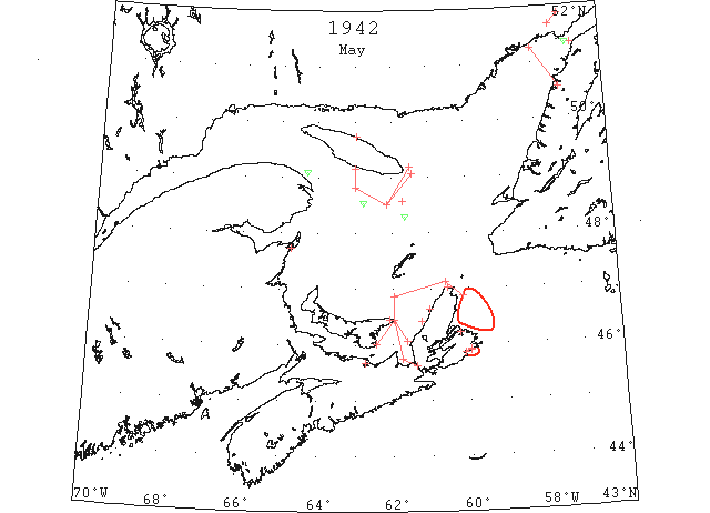
May The gradual clearing of the gulf from the S and W in the 1943 season is a sharp contrast to that of the 1942 season in which the Cape Ray to Fame Point track opened first, and the Gut of Canso – Northumberland Strait track was blocked by ice until early May. (IIP 1943 p17)
May 1 DOT aerial survey: East Point, PEI heavy drift and field ice closely packed in gulf and strait narrow lane of water along shore in strait. (CIS IC0977_3)
May 1 First arrival of season at Quebec. (WBB)
May 2 Canso Strait full heavy drift. East Point PEI heavy drift and field close packed gulf and strait. East coast Cape Breton ice moved off. Sydney, Canso no ice in sight (IIP 1946 p10)
May 2 Shippigan Bay full. Pictou ice outside. Entrance Louisburg Harbor scattered drift. 30 miles south of Heath Point patches and strings. Sydney harbor open. Elmira heavy close packed in gulf and strait (IIP 1946 p10)
May 2 DOT aerial survey: Few scattered pieces in Sydney harbour. (CIS IC1026_2)
May 2 DOT aerial survey: Clear westward to Canso with exception of a little ice in Gabarus and entrance to Louisburg harbour. (CIS IC1080_2&IC1090_2)
May 2 DOT aerial survey: 2 growlers 48°18’N 61°40’W. Patches and strings from 10 miles NE of Heath Point to 48°31’N 62°08’W to 48°50’N 63°00’W and along the 63rd meridian to Anticosti. Within this area easily navigable. (CIS IC0794_2)
May 2 DOT aerial survey: Sighted 3 growlers westward of Table Head, Anticosti, (CIS IC0857)
May 2 Lobster season opened, no mention of ice. (Pat 2 May p8 c3)
May 3 DOT aerial survey: Large body of ice to the N of Cape George now moving northward and is close packed on E coast of PEI from Cape Bear to East point and route via East Point not navigable at present. (CIS IC0977_4)
May 4 Gulf route open except pack from 10 miles east Heath Point to 48°31’N 62°08’W, 48°50’N 63°00’W north to Anticosti. Chedabucto Bay and Strait Canso to George Bay to East Point PEI considerable drift ice. Closed packed vicinity PEI. Gabarus Bay and entrance Louisburg light patches (IIP p1946 10)
May 4 Pictou heavy drift outside. Meat Cove open ice to shore. Cheticamp ice off shore fast. (IIP 1946 p10)
May 4 Woods Islands – Caribou ferry yesterday and took up regular service. (Pat 5 May p8 c3)
May 5 DOT aerial survey: Large body of ice which was in the vicinity of East Point, PEI and George Bay is now loosening up and moving rapidly eastward. This ice is bounded by the following lines today from 5 miles NW of Port Hood Island to East point, PEI to 25 miles N of East Point to 5 miles off Cape St. Lawrence with loose ice and string extending to 15 miles E of Cape North. Within this area loose and open ice with large lakes of open water. This ice will move down E coast of Cape Breton and is liable to block Sydney Harbour. (CIS 0977_4)
May 6 Pack 5 miles northwest of Port Hood Island to east point PEI to 25 miles off 15 east Cape North. Other gulf routes clear (IIP 1946 p10)
May 7 Pictou drift ice outside. Elmira scattered drift off shore in strait. Cheticamp ice on shore. Berg 49°06’N 64°18’W. (IIP 1946 p10)
May 10 48°33’N 62°47’W berg. (IIP 1946 p10)
May 15 50°33’N 57°15’W to Canadian coast floes 15 to 20 miles. 51°20’N 56°50’W floe (IIP 1946 p10)
May 21 Pack begins 51°51’N[?] 57°10’W extends southwest 15 miles, width 300-500 yards. South 50°45’N only few scattered bergs (IIP 1946 p11)
May 26 51°10’N 57°15W Belle Isle Strait west end clear. 51°20’N 57°00’W bergs in channel and by north shore, broken floe in channel (IIP 1946 p11)
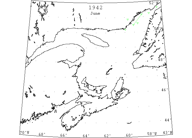
Jun 2 Berg 50°51’N 59°40’W, 50°10’N 59°57’W, several 50°28’N 59°06’W to 51°10’N 58°09’W (IIP 1946 p11)
Jun 17 Berg 51°12’N 57°23’W. 2 bergs 51°34’N 56°32’W (IIP 1946 p11)
Jun 23 50°34’N 58°38’W berg (IIP 1946 p11)
Jun 29 First Westbound steamer through the strait of Belle Isle. (WBB)