1939 Season
Dec 1 Last eastbound steamer through the Strait of Belle Isle. (WBB)
Dec 5 Last departure of the season from Quebec. (WBB)
Dec 26-29 Schooner Nellie Dixon, Capt Trenholm carrying a cargo of potatoes from Charlottetown and bound for Sydney, C.B., sailed from here Monday the 26th for that port. Other vessels sailed 29th. (Pat 3 Jan 1939 p2 c3)
Dec 31 Motor Vessel O.K. Service loaded with produce, sailed from Lower Montague for Halifax Saturday morning (31 Dec.). (Pat 5 Jan 1939 p2 c2)
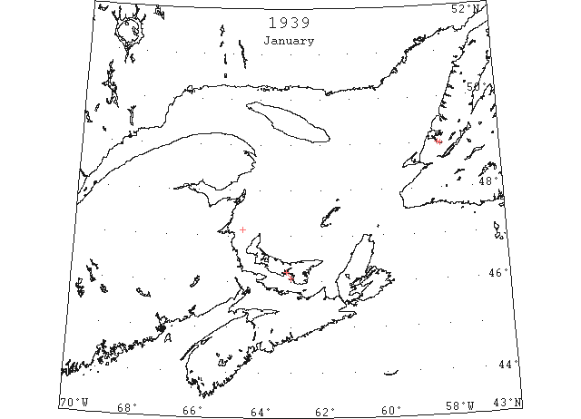
Jan 4 “Brant” had to break ice between Charlottetown Harbour and Point Prim. Open water 6 miles outside Point Prim ice 5″ thick rafted to 12″. (Pat 4 Jan p1 c4)
Jan 6 SS “Surf” sailed from Georgetown this morning for Sydney. (Pat 6 Jan p5 c7)
Jan 7 “Karmoy” and the “Brant” were both fast in heavy ice nine miles south west of Point Prim. (Pat 7 Jan p1 c8)
Jan 8 Off Cape Bear there was open water. “Karmoy” arrived at Souris on 8th. (Pat 9 Jan p1 c9)
Jan 10 “Karmoy” reached Georgetown this morning. (Pat 10 Jan p1 c5)
Jan 12 SS “Karmoy” cleared Georgetown for Newark, N.J; clear water outside Georgetown. (Pat 12 Jan p1 c1)
Jan 18 Last year a coating of ice formed on Humber Arm out to Meadows on 2nd Jan. This afterwards broke up, but on the 16th people were skating, and crossings could be made over the Arm from Summerside to Curling. This year there has been no ice to date except just a little shifting slob. (TWS, pg. 2, Col. 4)
Jan 28 The first ice boat of the season was on Humber Arm yesterday. The frost of last Tuesday night and Wed. made a sheet of ice over Humber Arm and extended beyond Frenchman’s Head and on Thursday people were able to cross it between Curling and Summerside, while there was good skating near the shore at Sprucy Point. Sun. night’s gale broke it and formed several lanes. These were closed again, however, by Mon night’s frost. (TWS, pg. 2, Col. 3)
Feb 1 The ice is in good condition for skating, but people have been prevented from enjoying it owing to high winds (Codroy). (TWS, pg. 1, Col. 6)
Feb 1 The SS ”Humber Arm” passed outward on Sat. closing navigation for this season. The frost the past few days has made the ice over Humber Arm quite firm It extends to Meadows. Many people are now fishing through the ice in Humber Arm. (TWS, pg. 2, Col. 2)
Feb 1 Eli Blagdon, 30, and his 17-year old companion Gordon Blagdon, no relation, after one unsuccessful attempt today crossed about a mile and a half of treacherous ‘lolly’ or shore ice to land at McNeil’s Point near here to seek aid for their ice-encircled ship, the 35-ton auxiliary schooner “Alfred Keepin.” The “Keepin,” victim of several misfortunes this year, became involved in the ice pack that forms a chain several miles wide along the shore between here and Sydney as soon as she cleared Sydney Harbor Monday evening for English Harbor, Nfld., with 26 tons of coal aboard. Drifting helpless along the shore she sighted Glace Bay Tuesday night. This morning Eli and Gordon Blagdon volunteered to try the perilous hike over the ice to shore in search of aid in the from of an ice breaker to open a path to ice-free water. The ‘lolly’ ice seemed fast enough but the risk of a changing wind and consequently loosening of pack present a hazard to the pair who went about a quarter miles before returning to the ice-bound ship. About 4:30 this afternoon the venturesome couple again left the schooner and after jumping a mile and a half of piled up ice cakes reached shore. (HH 02/02/1939 p9#7,8)
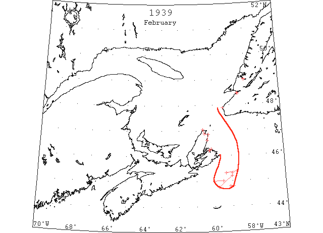
Feb 7 Cape Race: Streaks and patches pancake ice 45°19’N 59°20’W to 45°22’N 58°45’W. (IIP p35#26)
Feb 8 Ice compels SS. “Caribou” call at Louisburg- Owing to the Gulf coast of Cape Breton being blocked with heavy ice, the SS “Caribou” has not been able to get into North Sydney on her trips across Cabot Strait the past week, as a result the ship has had to go to Louisburg on her last three trips. (TWS, pg. 1, Col. 6)
Feb 8 During the week the Harbor has completely frozen over and teams can be seen daily crossing to Sandy Point (St. Georges’). (TWS, pg. 2, Col. 6)
Feb 9 Cape Race: Field ice 44°47’N 59°07’W to 44°48’N 58°57’W. (IIP p35#28)
Feb 9 Cape Race: Slob ice 45°18’N 59°00’W. (IIP p35#31)
Feb 9 Cape Race: Broken ice 45°12’N 59°00’W to 44°45’N 59°45’W. (IIP p35#32)
Feb 9 The following ice information has been received from Cape Race Radio Station (VCE) through the Department of Transportation, Canada: Field ice from 44°47’N 59°07’W to 44°48’N 58°57’W; slob ice, 45°18’N 59°00’W; field of broken ice north of line from 45°12’N 59°00’W to 44°45’N 59°45’W. (HB 2580 Feb 15)
Feb 11 Cape Race: Patches field and slob ice 45°00’N 59°30’W to 45°00’N 60°00’W. (IIP p35#33)
Feb 15 The drift ice has made its appearance in Codroy and for a few days the temperature at times has dropped below zero. (TWS, pg. 1, Col. 3)
Feb 27 Cape North: coast line here is entirely blocked with heavy drift ice, making navigation extremely difficult. The blocked area extended from Bay St. Lawrence on the extreme North Eastern tip of Cape Breton Island to beyond Cape Smokey. The heavy drift ice has been brought to the coast by prevailing Northerly winds. Navigation ceased early this month and will not be resumed again until sometime in April. (HH 28/02/1939 p12#8)
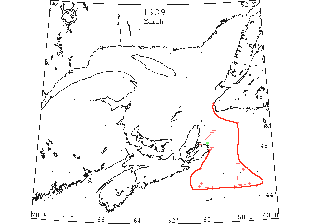
Mar Heavy pack ice was reported on the 13th off Cape Breton but inasmuch as the St. Lawrence River was not open to shipping no reports were received regarding ice conditions in the Gulf of St. Lawrence. (IIP p7)
Mar 1 The ice is packed in close to the land putting a stop to the fishing. (TWS, pg. 1, Col. 5)
Mar 1 SS “Corner Brook” damaged by ice- yesterday the SS “Corner Brook” was at LaPoile in a disabled condition owing to her steering gear having while the ship was in heavy ice, outward bound from that place. (TWS, pg. 7, Col. 7)
Mar 5 Glace Bay: Two large mountains of ice disappeared to the south Saturday after hoving into view of the coast near here Friday. Local fishermen said it was unusually early for northern ice to arrive this far south. The icebergs were first sighted off the coast in a position that led observers to believe them to be schooners. They followed the path where coastal shipping is usually seen. During Saturday they came closer to shore and continued southward. (HH 06/03/1939 p9#6)
Mar 9 Cape Race: Heavy drift ice 45°30’N 58°00’W. (IIP p35#60)
Mar 10 North Sydney: The position of the “Caribou” held fast in the close-packed drift ice 40 miles off this port, remained unchanged from a report at 3 pm Wednesday [Mar 8]. Bearing 20 passengers and a crew of 42 from Port aux Basques, Nfld., bound for North Sydney, the “Caribou” left the Newfoundland port early Wednesday morning and 61-2 [6 ½] hours later reported herself making little progress through the increasingly heavy drift ice. In the next wireless communication, at 12:30, Wednesday afternoon, her position indicated she had gone seven miles in the intervening five hours. At 3 pm the same day she reported no further progress. Ice continued to pack around the sturdy 2,222 ton ship, built to withstand the pressure of ice, but no fear were held for the 62 souls aboard. Getting stuck in the ice is unusual for the “Caribou” but not without precedent. Last year she was halted by the tightly compressed ice of the Cabot Strait for 48 hours but nearer shore. Several more impatient passengers undertook on that occasion to walk over the ice to shore. A change in wind has been pushing the ice inshore that last few days will release the ship, it is expected but just when the right wind will free the imprisoned craft, no local weather-wise longshoreman was willing to predict today. (HH 11/03/1939 p9#8)
Mar 10 The following radiogram [was] received from the U.S. Coast Guard cutter “Chelan”: a.m. position, 42°20’N 67°42’W. [No ice seen.] p.m. position, 42°26’N 64°34’W. [No ice seen.] (HB 2584 Mar 15)
Mar 10 The following radiogram [was] received from the U.S. Coast Guard cutter “Chelan” [on Mar 11]: Ice reported Mar. 10, heavy drift ice, 47°03’N 58°00’W. (HB 2584 Mar 15)
Mar 11 The following radiogram [was] received from the U.S. Coast Guard cutter “Chelan”: a.m. position, 42°38’N 60°34’W. [no ice reported from this vessel position] p.m. position, 42°42’N 56°52’W. No ice sighted or reported sighted. (HB 2584 Mar 15)
Mar 12 “Manchester City” open pan ice extending north 44°30’N 60°25’W to 44°25’N 59°40’W. (IIP p35#65)
Mar 12 “New Texas” Field ice all directions 45°38’N 60°00’W. (IIP p36#66)
Mar 12 “Manchester City” heavy field ice all directions 44°25’N 57°08’W to 44°30’N 58°05’W. (IIP p36#68)
Mar 12 “Beaverbrae” field ice extending south 44°25’N 58°24’W to 44°32’N 57°31’W. (IIP p36#70)
Mar 12 The following radiogram [was] received from the U.S. Coast Guard cutter “Chelan”: Ice reported sighted today: Heavy field ice extending in all directions from 44°25’N 57°08’W to 44°30’N 58°05’W; field ice extending east and west as far as can be seen from 45°08′ 53°40′; field ice in all directions as far as can be seen from 45°38’N 60°00’W; open pan ice extending north as far as can be seen from 44°30’N 60°25’W to 44°25’N 59°40’W. (HB 2584 Mar 15)
Mar 12 The following radiogram [was] received from the U.S. Coast Guard cutter “Chelan”: Ice reported sighted late [today]: Field ice, extending south from 44°25’N 58°24’W to 44°32’N 57°31’W. (HB 2584 Mar 15)
Mar 12 Louisburg: Sailing from this port at one o’clock today the Newfoundland steamer “Caribou” was making ‘progress’ through heavy field ice, message received here early this evening stated. Closely packed ice held up the 2,222 ton ship from early Wednesday [8th] morning until late Friday night when she managed to work her way out of the field and warped into the terminus wharf here at 10 o’clock Saturday morning. After arrival, 24 passengers disembarked and were transported by rail to Sydney. The “Caribou” carries a crew of 42. Between four and five o’clock today port officials here were notified by the master of the “Caribou” that the steamer was making her way slowly through the field which extends for miles off the coast, and was experiencing no difficulty so far on the return journey to Port aux Basques. The ship left Port aux Basques for North Sydney shortly after midnight on Wednesday morning and at 7:30 reported heavy ice delaying progress. Five hours later she ‘spoke’ to shore and had only negotiated seven miles since the previous message. At 3:30 Wednesday afternoon the “Caribou” reported no further progress through the wind packed drift ice. From that time until Friday night the sturdy little craft, built in the Netherlands especially for the Newfoundland-Canada run, was held fast. Emerging from the blockade of ice just off the harbor mouth of Sydney, she made for Louisburg, her usual port of call when the North Sydney Harbor is not navigable, arriving here Saturday morning. (HH 13/03/1939 p9#7,8)
Mar 13 Cape Race: Heavy rafted pack ice south Scatari Island. (IIP p36#74)
Mar 13 Cape Race: Heavy rafted pack ice east coast Cape Breton Island. (IIP p36#75)
Mar 13 The following radiogram [was] received from the U.S. Coast Guard cutter “Chelan”: a.m. position, 43°00’N 53°00’W; Ice reported late March 13: heavy rafted pack ice south of Scatari and along east coast of Cape Breton. (HB 2585 Mar 22)
Mar 14 “Vingaren” slob ice 45°22’N 58°07’W to 45°07’N 57°49’W. (IIP p36#77)
Mar 14 The following radiogram [was] received from the U.S. Coast Guard cutter “Chelan”: a.m. position, 42°56’N 52°45’W. Ice reported sighted late March 14: Slob ice from 42°22’N 58°07’W to 45°07’N 57°49’W. (HB 2585 Mar 22)
Mar 15 The SS “Caribou” on her way across Cabot Strait on Wed. become jammed in heavy ice off Satterie and did not reach Louisburg until Sat. She left on return trip shortly afternoon on Sun and in 24 hours made only 16 miles progress. (TWS, pg. 1, Col. 6)
Mar 15 After about 40 hours crossing the Cabot Strait from Louisburg the SS “Caribou” reached Port aux Basques yesterday morning after being about 6 days the round trip. (TWS, pg. 2, Col. 3)
Mar 15 North Sydney: The “Caribou” last week involved in heavy ice off Sydney Harbor, almost 60 hours reported today she was again held up by the abnormal ice conditions and was making for Louisburg on the south coast. The ice was encountered about 40 miles off shore, approximately the same spot where the vessel was hemmed in by ice a week ago. (HH 16/03/1939 p9#1)
Mar 16 “Brant County” heavy field ice 46°05’N 59°36’W to 45°15’N 60°20’W. (IIP p36#82)
Mar 16 “Brant County” heavy field ice south southwest 45°00’N 60°50’W. (IIP p36#83)
Mar 16 The following radiogram [was] received from the U.S. Coast Guard cutter “Chelan”: heavy field ice extending south-southwest from 45°00’N 60°50’W; heavy field ice as far as can be seen from 9 miles east of Cape Breton to 45°15’N 60°20’W. (HB 2585 Mar 22)
Mar 22 Due to heavy ice in the Straits, the SS “Caribou” has made only 2 trips during the past 2 weeks (TWS, pg. 1, Col. 3)
Mar 22 The SS “Caribou” which sailed from Channel-Port aux Basques on Wed. became jammed in the ice and did not reach Louisburg until Sat. (TWS, pg. 3, Col. 1)
Mar 22 Drift ice is packed tight to the land in Codroy. (TWS, pg. 4, Col. 5)
Mar 24 “Liberty” patches slob ice 45°15’N 57°46’W. (IIP p37#125)
Mar 28 “P.N. Damm” scattered ice 44°34’N 56°43’W. (IIP p37#154)
Mar 29 Cape Race: Large ice field 44°24’N 60°41’W. (IIP p37#155)
Mar 29 The SS “Caribou” was so delayed by the ice crossing Cabot Strait that the express train bringing her mails and passengers arrived 38 hours behind schedule. (TWS, pg. 3, Col. 2)
Mar 31 “Duchess of York” patches of slob ice 44°37’N 60°17’W and 44°46’N 58°12’W. (IIP p37#160&179)
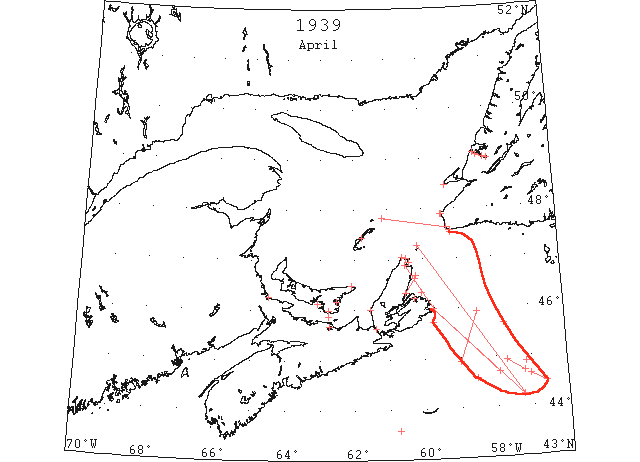
Apr The Canadian icebreaker “N.B. McLean” commenced Ice Patrol in the Gulf of St. Lawrence on Apr.9. Strings and patches of field ice were reported extending 150 miles SE of Scatari Island and heavy solid pack ice extended across the entrance of the bay. Navigation in the Gulf of St. Lawrence and St. Lawrence River was delayed this year, the first vessels passing up the Gulf on Apr. 20th escorted by the “N.B. McLean”. (IIP p7&8)
Apr The State of the Arctic Seas, Copenhagen, 1939: … after passing South Point, Anticosti, until arrival off Cape Ray, no open water was seen, the eastern part of the Gulf from Anticosti Isle southward to Magdalen and eastward to Newfoundland being completely covered with ice of various thicknesses. (CIS IC0712)
Apr 1 “Fort Amherst” heavy broken ice extending N and S 44°53’N 57°10’W. (IIP p38#189)
Apr 1 “Norwegian” pieces broken ice 43°35’N 60°45’W. (IIP p38#197)
Apr 4 Cape North: Seal fishermen of Bay St. Lawrence reported yesterday they had ‘talked’ to members of the crew of the Newfoundland sealer “Terra Nova” while they were at work some seven miles off the coast Tuesday [4th] evening. The fishermen stated that the sealer had had very good luck during the past few days and that they had captured more than 5,000 seals. The sealer set out from St. John’s early last month on the annual seal hunting expedition and later was reported caught in the ice near the Magdalen Islands. However, she managed to free herself and continue the expedition. Residents of Meat Cove, Capstick and Bay St. Lawrence have caught and slaughtered over three hundred seals within the past few weeks. Old residents around here declared that the large number of seals could be attributed to the heavy ice that has surrounded the shore all along the Cape Breton coast. Some of the old timers here say they cannot recall when seals came so near shore and in such large numbers as is the case this year. (HH 07/04/1939 p15#7)
Apr 5 The SS “Caribou” due to reach Port aux Basques on Thur. owing to ice did not arrive until Fri afternoon. (TWS, pg. 1, Col. 6)
Apr 5 Ice conditions interfere Cabot Strait service- The ice blockade along Cape Breton coast continues to interfere with the Cabot Strait service, preventing the SS “Caribou” to reach North Sydney, and the ship has to make Louisburg each trip. (TWS, pg. 2, Col. 4)
Apr 5 Three ice breakers are employed clearing the St. Lawrence River ship channel. It is expected to have the channel to Montreal opened three days earlier than last year. (TWS, pg. 2, Col. 4)
Apr 5 It is many years since we have seen the harbor channels frozen solid as late as this date in the year. (Codroy) (TWS, pg. 8, Col. 3)
Apr 6 Montreal Gazette: At the moment it appears doubtful that the St. Lawrence will open for navigation next week but nothing definite is known, Cold weather has set back the season more than 2 weeks, and steady warmth will be required to guarantee the opening of navigation on the expected date, which is around April 16. There is still considerable ice in the river but it is breaking up and moving out gradually. (CIS IC0711)
Apr 6 “John W. Mackay” scattered ice 45°43’N 59°45’W. (IIP p38#204)
Apr 6 “P.N. Damm” field ice extending eastward 2 miles offshore Port Aux Basques. (IIP p38#206)
Apr 6 Department of Transport officials at Halifax said yesterday the Canadian Government ice-breaker “Montcalm” was on her way to St. Paul’s Island with John Stevenson, light keeper, shown above, who had been receiving treatment at North Sydney for an injured ankle. She reached a point five miles from Cape Smokey when the ice closed in on her. Since then she has drifted back to within three or four miles of Big Bras d’Or, one of the entrances to the Bras d’Or lakes, about 25 miles. (HH 07/04/1939 p9#1,2)
Apr 7 Montreal Gazette: There is information to the effect that ice in the straits (Cabot) is much thicker than it was last year. (CIS IC0711)
Apr 8 “Beaverbrae” brash ice extending north 44°55’N 59°00’W to 45°55’W 58°30’W. (IIP p38#245)
Apr 10 The Canadian Government ice-breaker “Montcalm” was still outside North Sydney harbor last night after battling closely-packed drift ice off Cape Breton since March 12. The “Montcalm” was on her way to the Gulf of St. Lawrence when she ran into the ice. Aboard was a St. Paul’s Island light keeper who had been under treatment at North Sydney for an injured ankle and who was to be dropped at the island. The “Montcalm” managed to get within 45 miles off St. Paul’s before the ice closed in on her and since then she has been fighting a losing battle. (HH 10/04/1939 p9#4)
Apr 10 Halifax Port: Thick, heavy ice on the St. Lawrence River, that refused to budge against the onslaught of powerful Canadian Government ice-breakers may prove to be a boom to Halifax stevedores and port workers as officials of several shipping companies announced over the week-end that liners scheduled to go to Montreal next week-end may come to Halifax. The “Montcalm” of the Canadian Pacific Line, together with the “Duchess of York” are en route to Canada from Antwerp, Cherbourg and Southampton and Greenock, Belfast and Liverpool, respectively, and were originally scheduled to go up the St. Lawrence to Montreal. However, unless the ice conditions on the river better during the first two days of the week, the liners will dock at Halifax instead. The two vessels are due to arrive at the port of Montreal on Saturday of next week, so if they are forced to dock here, they will arrive Thursday. (HH 10/04/1939 p12#8)
Apr 10 Louisburg: After spending almost a month stuck in heavy drift ice off the Cape Breton coast, the Canadian Government icebreaker “Montcalm” limped into this port Saturday night with a broken rudder. The government ship was brought in by using her screws for steering and tonight was ‘awaiting orders.’ Commanded by Captain John Hearn, the ship was en route to isolated St. Paul’s Island, 13 miles off the extreme tip of Cape Breton with a lighthouse keeper. When 45 miles from that island she was obliged to turn back and became involved in the ice floes. Unable to enter the heavily iced entrance of Sydney harbor, the sturdy icebreaker proceeded to this port where she bunkered today. (HH 11/04/1939 p9#4)
Apr 10 North Sydney: Fishermen and residents of Capstick, Victoria County, generally have reaped a good harvest this Spring from the close-packed ice surrounding Cape Breton island. More than 2,000 seals inhabiting the floes along the coast near that northern village have been taken by residents. Still more seals are expected to be taken before the Cabot Strait is clear of the seal-bearing ice. The unexpected catch was to many residents the first source of income during this year. (HH 11/04/1939 p9#5)
Apr 11 “Lord Kelvin” field ice extending north 44°35’N 58°33’W. (IIP p39#261)
Apr 12 The drift ice is packed tight to land (TWS, pg. 2, Col. 2)
Apr 12 Montreal Gazette: The icebreaker “N.B. McLean” working her way slowly through Cabot Strait yesterday could give no indication as to when the route through the Gulf would be opened to navigation. In the meantime, Montreal-bound vessels were ordered diverted to Saint John and Halifax… Last message from the “McLean” yesterday stated : “24 miles from St. Pauls Island. Light SW wind, clear. Heavy close-packed ice in all directions. Complete barrier of heavy ice blocks Cabot Strait and no ships can get through at present. Now working slowly through.” Previously she had reported from a position near Bird Rock, stating, ‘Very large unbroken sheets packed between snow and slob; all very soft, but becoming harder as we proceed southward, and too heavy for ordinary ships to pass through. A few hot days with a swell through this ice and it would disappear, but under present conditions, and unless we find a better route further south, chances for other ships getting through are not promising!’ Reports from the Great Lakes were not encouraging, with temperatures in the Lake Superior regions averaging below freezing. (CIS IC1010-1010_2)
Apr 12 Halifax: Prevailing ice conditions in the Gulf of St. Lawrence caused officials of the Cunard White Star Company, Limited, and the Canadian Pacific Steamships to make a hurried change in plans yesterday concerning the Canadian terminal of their westward bound liners, originally due at the port of Montreal this coming week-end. (HH 12/04/1939 p12#5)
Apr 12 Pictou: The Pictou-Pictou Landing Ferry “Ashagola” made her first harbor crossing yesterday. The first trip last year was made April 6. The upper harbor is still ice-locked but Northumberland Strait was reported clear of ice today. (HH 13/04/1939 p9#8)
Apr 14 “N.B. McLean” Gulf St. Lawrence and Cabot Strait covered with ice. (IIP p39#296)
Apr 14 “N.B. McLean” ice extending SE East coast Cape Breton and Scatari Islands. (IIP p39#297)
Apr 14 Canadian Ice Patrol vessel “N.B. McLean”: Navigation in the St. Lawrence River and Gulf is much delayed this year and the eastern part of the Gulf and Cabot Straits are still covered with ice, and passage is not possible for ordinary ships at present. Ice extends along the east coast of Cape Breton to Scatari and beyond and some of this ice was reported on April 13, 110 miles southeast of Scatari. With fresh northwest winds in the Gulf today, there is a slight improvement in ice conditions. Vessels via Cape Race bound for the Gulf should not pass to the westward of St. Pierre for the present. Route by way of Canso is still blocked. Louisburg Harbour is clear. (HB 2589 Apr 19)
Apr 15 “N.B. McLean” Gulf St. Lawrence and Cabot Strait covered with ice. (IIP p39#315)
Apr 15 “N.B. McLean” ice extending SE East coast Cape Breton and Scatari Islands. (IIP p39#316)
Apr 15 The following radiogram [was] received from the U.S. Coast Guard cutter “Chelan”: Ice reported sighted late April 15: Slob ice, 44°55’N 57°42’W. (HB 2589 Apr 19)
Apr 16 “Beaverdale” slob ice extending NW 44°42’N 57°12’W to 44°55’N 57°42’W. (IIP p40#337)
Apr 16 Cape Race: Gulf St. Lawrence covered with ice. (IIP p40#339)
Apr 17 Montreal Gazette: Several freight ships stood off Cape Race yesterday, waiting hopefully for a change in conditions that would make navigation possible through Cabot Strait and into the Gulf of St. Lawrence. But last report from the icebreaker “N.B. McLean”, received by Signal Service yesterday morning said that the Strait was still close packed with ice. (CIS IC1010_2)
Apr 18 “N.B. McLean” Gulf St. Lawrence covered with ice. (IIP p40#364)
Apr 19 “N.B. McLean” Gulf St. Lawrence covered with ice. (IIP p40#372)
Apr 19 “N.B. McLean” patches ice extending 150 miles SE Scatari Island. (IIP p40#373)
Apr 19 “Catla” heavy field ice 44°38’N 57°03’W to 44°28’N 56°37’W. (IIP p40#385)
Apr 19 The ice in Humber Arm shows little or no signs of “giving up” and there is little likelihood of navigation opening before the early part of May. The ice extends to Lark Hr., but the easterly winds of late have taken it from the islands. After nearly2 months ice blockade the port of North Sydney was opened to navigation last week by the Canadian icebreaker Mont Calm and the SS “Caribou” made that port last Wed. morning on her trip across Cabot Strait from Port aux Basques, for the first time since early Feb. (TWS, pg. 2, Col. 5)
Apr 19 The ice conditions in the Bay at the present time are causing a delay in the preparations for the drive in the various rivers. Until such a time as the Corner Brook boom area is clear of ice so that driven wood may be boomed, there is not much likelihood of the drive on the rivers being started. Apparently this will not be until the first past of May. (TWS, pg. 5, Col. 7)
Apr 19 Last year boats crossed from Petipas Cove to Curling on Apr. 19. The previous year the Arm was clear on Apr. 23. (TWS, pg. 5, Col. 7)
Apr 19 Montreal Gazette: The icebreaker “N.B. McLean” patrolling Cabot Strait, reported yesterday she was still in the ice, but had steamed for a long distance at 10 knots, which indicated the field was soft and brought hope of better conditions within a short time. Captain Balcom stated that much of the ice then encountered was soft and looked like “second crop”. In a previous message he said that conditions were fairly good around Cape Anguille on Newfoundland Coast, but that ice was jammed to the shore farther north. (CIS IC1010_3)
Apr 20 “N.B. McLean” Gulf St. Lawrence eastern part covered with ice. (IIP p41#389)
Apr 20 “N.B. McLean” patches ice extending 150 miles SE Scatari Island. (IIP p41#390)
Apr 20 Canadian Ice Patrol vessel “N.B. McLean”: Navigation in the St. Lawrence River and Gulf is much delayed this year and the eastern part of the Gulf and Cabot Straits are still covered with ice and passage through is not possible. Clear water extends from Fame Point to south true from Heath Point. Eastward of that the Gulf and Cabot Strait is[sic] covered with ice extending with strings and patches 150 miles southeast of Scatari. Conditions are improving and it is expected that passage through will be possible shortly. Ships via Cape Race bound for the Gulf should not pass to the westward of St. Pierre for the present. Route by the way of Canso is still blocked, Louisburg clear. (HB 2590 Apr 26)
Apr 20 Halifax: Only four ocean vessels are scheduled to arrive here over the weekend to load or discharge cargo, it was learned today from agents. However, local Department of Marine officials declared yesterday afternoon that the ice was still thick on the Gulf of St. Lawrence and it is very probably that the Cunard White Star liners “Aurania” and “Athenia” will arrive here. (HH 20/04/1939 p14#5)
Apr 21 “N.B. McLean” Field ice extending S and SE St. Paul’s and Scatari Islands. (IIP p41#419)
Apr 21 “N.B. McLean” considerable ice in eastern part Gulf St. Lawrence. (IIP p41#420)
Apr 21 Montreal Gazette: The 4 ships which had stood off Cape Race on the Newfoundland coast for several days owing to an ice blockade in Cabot Strait, were escorted through there yesterday by the “N.B. McLean”. She took them through the ice to open water in the vicinity of Bird Rock, and they proceeded from there unescorted” (CIS IC1010_3-1010_4)
Apr 21 Canadian Ice Patrol vessel “N.B. McLean”: Navigation in the St. Lawrence River and Gulf is much delayed this year and the eastern part of the Gulf and Cabot Straits has still considerable ice over the route, but conditions have improved. Open water extends from Fame Point to Bird Rocks this morning and strong southeast winds today have broken up the pack ice in Cabot Straits. The first ships are passing up the Gulf today convoyed by the “N.B. McLean”. There is still a large body of ice south of St. Paul [Island] extending out to the southeastward and strings and patches of this ice have been reported 150 miles southeast of Scatari. Route by the way of Canso via East Point and Northumberland Straits not navigable; Louisburg and Canso Harbours are open. (HB 2590 Apr 26)
Apr 22 First arrival of season at Quebec. (WBB)
Apr 22 Cunard White Star port workers and Canadian National Steamship employees made a general exodus from Halifax yesterday as official word was received from Montreal that the Gulf of St. Lawrence was open and that ships would be docking at least at Quebec this weekend. (HH 22/04/1939 p17#8)
Apr 23 “N.B. McLean” considerable ice in eastern part Gulf St. Lawrence. (IIP p41#446)
Apr 23 “N.B. McLean” St. Paul’s, large body ice S of and ice extending 150 miles SE from Scatari. (IIP p41#447)
Apr 23 The following radiogram [was] received from the U.S. Coast Guard cutter “Chelan”: large body of ice south of St. Paul [Island] and extending southeast 150 miles from Scatari Island. Considerable ice on eastern part of Gulf of St. Lawrence. (HB 2590 Apr 26)
Apr 24 Halifax Chronicle: Route by way of Canso via East Point and Northumberland Strait not navigable but conditions clearing up. Louisburg and Canso harbours are open. Canso, moderate SW winds, no ice in sighted, Port Hood, bay full of ice, Mulgrave NW wind, some scattered ice in Strait. (CIS IC0967)
Apr 24 Halifax Chronicle: Port Hood; bay full of ice, Elmira PEI, ice 1 to 2 miles N, clear in Strait. Georgetown, PEI, the C.G.S. “Montcalm” will proceed immediately to Georgetown to clear the harbour of ice so that fishermen can work offshore in their small boats. (CIS IC0984)
Apr 24 Halifax Chronicle: Navigation in the Gulf and river is much delayed and the eastern part of the Gulf and Cabot Strait has still considerable ice over the route but conditions are improving. Open water extended down from Fame Point to Bird Rocks and strong SE wind has broken up the pack in Cabot Strait and ships are now passing up the Gulf. There is still a large body of ice S of St. Pauls extending out to the SE and strings and patches of this ice have been reported 150 miles SE of Scatari. (CIS IC0711)
Apr 24 Ice needs to be broken in Georgetown for the purpose of the fishermen moving their boats. (Pat 24 Apr p1 c6)
Apr 25 Charlottetown Harbour was clear of ice. SS “Montcalm” working outside the harbour (Charlottetown) breaking up the ice across Brighton Range channel. reports the ice there “very hard” in places. The ice from Wood Islands … more or less broken pans. (Pat 25 Apr 1939, p1 c6)
Apr 25 Grindstone, MI – Magdalen Islands surrounded with drift ice. Pleasant Bay clear. (HH 25/04/1939 p15#6)
Apr 26 Last year navigation in Humber Arm opened on 22nd Apr. and the following day the first steamer arrived. The previous year it opened 23rd Apr. This year it is not likely to open before sometime in May. Even points of water are not yet showing up. (TWS, pg. 2, Col. 3)
Apr 26 There has been a few fine days the past week, but the ice is still around, preventing the men in getting out to the fishing grounds. (TWS, pg. 7, Col. 5)
Apr 26 Grindstone, MI – Magdalen Islands surrounded with drift ice. Pleasant Bay pretty well clear. (HH 26/04/1939 p13#6)
Apr 27 “Trontolite” field ice 45°40’N 57°45’W. (IIP p42#488)
Apr 27 Canadian Ice Patrol vessel “N.B. McLean”: The Gulf and Canso Strait have still considerable ice extending from Bird Rocks eastward but this ice is loosening up and ships are now passing through unassisted. The route by way of Canso to Charlottetown and Pictou is now navigable but the route [via] East Point, Northumberland Straits is not recommended yet. The ice extends out to the southeast of Scatari. Ice reported today, 45°40’N 57°45’W, by M.S. “Trontolite”. Several ships passed from Scatari to Cape Ray without much difficulty. Ships should time their voyage to pass from Cape Ray to Bird Rocks in daylight. (HB 2591 May 3)
Apr 27 Grindstone, MI – Magdalen Islands surrounded with drift ice. Pleasant Bay clear. (HH 27/04/1939 p15#6)
Apr 28 “N.B. McLean” light open ice from Cape Ray to Bird Rocks. (IIP p42#521)
Apr 28 Canadian Ice Patrol vessel “N.B. McLean”: Clear water extended from Fame Point down to Bird Rocks and beyond. From there to Cape Ray light open ice with large leads. Ships bound up gulf from Cape Race steer to pass 12 miles off St. Pierre, to 5 miles off Cape Ray, to 15 miles off Bird Rocks to Fame Point. Several ships have passed through Canso Strait to Northumberland Straits with progress westward of Wood Island not possible yesterday. No definite information on the East Point, P.E.I., route. (HB 2591 May 3)
Apr 28 North Sydney: The schooner “Susan Benette” for North Sydney and Sydney reported considerable ice along the Victoria County coast line. A large amount of drift ice is still floating around Aspy Bay and at Cape St. Lawrence. The ice appears to be exceptionally heavy and is closely packed. The coastal steamer “Aspy,” owned and operated by the North Shore Steamship Company is expected to make her first trip of the season from Sydney, late this week to Ingonish, Neil’s Harbor, White Point and Dingwall providing the conditions are favorable. Pictou, April 28 – Scattered drift ice in Northumberland Straits delayed the SS “Manchester Spinner” after she left port yesterday. Heavy ice is reported in the Straits, and the big collier anchored for several hours off the Bay View shore before proceeding towards Levis, Que., her destination. Ingonish, April 28 – A quantity of drift-ice is still in sight from here, but fairly strong off-shore winds have kept it away from the shore up to the present time. A few seals have been caught by local sealers, but apparently the ice-field which carried a very large number of seals passed without coming in sight of Ingonish. At Cape North and vicinity a real seal harvest was reaped. (HH 29/04/1939 p17#8)
Apr 28 Grindstone, MI – Magdalen Islands surrounded with drift ice. Pleasant Bay clear. (HH 28/04/1939 p15#6)
Apr 29 Halifax Chronicle: Motor traffic by means of the auto ferries “Pont du Canso” and “Sir Charles Tupper” commenced on the Strait of Canso strait by a strong SE breeze. For some time the heavy ice has kept the ferry boats from moving form their docks and motorists to and from Cape Breton either had to cross on the train ferry Scotia to point Tupper or go to Arichat on the “O-We_Ra” (CIS IC 0967)
Apr 29 Halifax Chronicle: “Along the northern Cape Breton coast it is quite densely packed but not very thick,” Capt. Balcom remarked and explained that it was the 2nd “crop” of this season that is passing out to sea now. Looseness of the ice pack will relieve the icebreaker of the necessity of convoying other vessels as long as conditions remain that way off Cape Ray, Capt. Balcom said. (CIS IC1010_4)
Apr 29 Grindstone, MI – Magdalen Islands surrounded with drift ice. Pleasant Bay clear. (HH 29/04/1939 p17#6)
Apr 29-30 The first docking at Quebec this season would be made over the weekend (April 29/30) after dodging huge ice cakes in the Gulf. (Pat 25 Apr p1 c8)
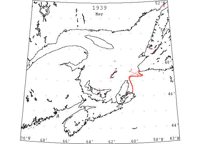
May 1 “Duchess of Atholl” loose pack ice 47°37’N 60°10’W to 47°24’N 59°25’W. (IIP p44#590)
May 1 “N.B. McLean” field ice 47°42’N 60°00’W. (IIP p44#593)
May 1 Charlottetown Patriot: “Only a bit of scattered shore ice remains in the bay here today to remind of a sealed harbour all winter. After a stormy weekend in which a big field of drift ice in the Strait of Northumberland threatened to jam into Shediac Bay yesterday in the teeth of a strong northerly wind, a shift of wind carried it out and with it went the remnant of the ice which had blocked the bay for months. Yesterday’s wind drove the bay ice toward the town shore, and, had the wind remained in that quarter, it probably would have piled it high on the beach between the Foch Bridge and the remains of the wharf. The sudden change last night, however, prevented this. Boats may be sailed at any spot in the bay today.” (CIS IC0946)
May 1 Rustico still some ice clinging to the shore inside the bay. (Pat 1 May p1 c3)
May 1 The following radiogram [was] received from the U.S. Coast Guard cutter “Champlain”: Ice reported sighted today: Field ice extending north from 48°16’N 61°35’W … and loose pack ice from 47°37’N 60°10’W to 47°24’N 59°25’W. (HB 2592 May 10)
May 1 Grindstone, MI – Magdalen Islands surrounded with drift ice. Pleasant Bay clear. (HH 01/05/1939 p13#7)
May 2 “N.B. McLean” field ice extending north 48°16’N 61°35’W. (IIP p44#594)
May 2-12 The State of the Ice in the Arctic Seas; Copenhagen, 1939: On May 2nd we transferred our sphere of operations to Sydney harbour and vicinity, the E coast of Cape Breton having been completely blocked, a strong easterly gale having packed the ice into the Bight so that it was impossible for ships to get through. This work was continued until May 12th when the situation having cleared up so that ships could make their way through without too much difficulty. (CIS IC1058)
May 2 Grindstone, MI – Magdalen Islands surrounded with drift ice. (HH 02/05/1939 p12#6)
May 3 With a chance of wind yesterday the ice in Curling moved off to another part of the Arm. There is a bar of ice across the outer part of the Arm which is expected to break up at any time, so that navigation is likely to open by the end of the week. (TWS, pg. 2, Col. 3)
May 3 Grindstone, MI – Magdalen Islands surrounded with drift ice. Pleasant Bay clear. (HH 03/05/1939 p12#6)
May 4 Grindstone, MI – Magdalen Islands surrounded with drift ice. Pleasant Bay clear. (HH 04/05/1939 p14#7)
May 4 Heavy drift ice in the Gulf of St. Lawrence was reported by the Western Union cableship “Cyrus Field” when she arrived here Thursday after spending more than a week repairing cable off Bay Roberts, Newfoundland. According to officers aboard the cable ship, the ice in the Gulf is so thick as to be almost impregnable. However, some of the officers were of the opinion that with warm weather the ice would soon pass away. No icebergs were seen by members of the crew. (HH 06/05/1939 p20#3)
May 5 Pictou: Ice in the Gulf of St. Lawrence and Northumberland Straits although reported not so heavy as it was, still continues to hamper lobster fishermen. Fishermen at the North side PEI are reported to have lost some traps, but the loss is not extensive. They were said to have set their traps with buoys instead of ice poles, and the gear was damaged by drift ice. The water is still so cold that the lobsters are ‘dead’, and not moving or feeding to any extent and hence not entering the traps, according to well informed lobsterman. (HH 06/05/1939 p9#3)
May 5 Grindstone, MI – Magdalen Islands still surrounded with drift ice. Pleasant Bay clear. (HH 05/05/1939 p12#8)
May 6 “Dix” Northumberland Straits moderate field ice. (IIP p45#689)
May 6 The following radiogram [was] received from the U.S. Coast Guard cutter “Champlain”: Ice reported today: Moderate field ice in Northumberland Strait. (HB 2592 May 10)
May 6 Grindstone, MI – Magdalen Islands surrounded with drift ice on out side. Three to six miles off shore on north side. No ice in sight off Etang du Nord. Pleasant Bay clear. (HH 06/05/1939 p17#7)
May 8 Sydney, (CP) Shipping off Cape Breton hampered for several days by heavy ice off the Island’s east coast, moved with increasing rapidity today as favorable wind loosened the pack and enabled ships to make their way unassisted to and from ports here. Five craft were making their way inward after spending many hours awaiting the opening in the ice pack. The “Sir Newton Moore,” “Shekatika,” “Lord Strathcona” and “Wanstead” slated to load coal at Sydney and Louisburg, could be seen working through the pack while several other craft whose departure was hindered by the ice were clear of it and bound for their respective destinations. Assisted by the Canadian Government icebreaker “N B McLean,” the collier “Anthea” cleared from Louisburg late yesterday bound for St. Lawrence ports, while the freighter “Corabella” also headed for the St. Lawrence, sailed from North Sydney. The collier “Rosecastle” arrived yesterday after fighting through the ice to load coal at Louisburg, while the collier “Singket” was expected to make port late today. All of the craft were forced to wait varying periods until shifts in the wind enabled them to get through to port. Shipping circles at nearby North Sydney said a number of smaller craft, schooners and coastal ships were awaiting further clearing of coast waters to make Cape Breton ports. (HH 09/05/1939 p9#8)
May 9 Grindstone, MI – Magdalen Islands surrounded with drift ice. Pleasant Bay clear. (HH 09/05/1939 p12#7)
May 10 Cape Race: Heavy field ice 47°17’N 59°25’W. (IIP p47#843)
May 10 The ice in Humber Arm broke up on Wed. out to Meadows. But a bar still remains across from Frenchman’s Head. (TWS, pg. 1, Col. 6)
May 10 Grindstone, MI – Magdalen Islands – No ice. (HH 10/05/1939 p12#7)
May 11 “Yorkwood” strings ice and growler extending to Cape Ray 47°20’N 50[59]°00’W to 47°20’N 60°00’W. (IIP p47#884)
May 11 Cape Race: Heavy field ice 47°17’N 59°25’W. (IIP p48#885)
May 11 The following radiogram [was] received from the U.S. Coast Guard cutter “Champlain”: Ice reported sighted today: strings of ice and growler extending to Cape Ray from 47°20’N 59°00’W to 47°20’N 60°00’W. (HB 2593 May 17)
May 12 Grindstone, MI – Excepting narrow strip scattered ice off Amherst and Etang du Nord, Magdalen Islands well clear of drift ice. (HH 12/05/1939 p16#6)
May 12 Pictou: The SS “Lovet” returned to Pictou Thursday from her first trip to the Magdalen Islands. The steamer was forced to go around North Point, PEI, on her outbound trip, to avoid drift ice. (HH 13/05/1939 p17#6)
May 13 Montreal Gazette: The “McLewan” worked around North Sydney during the past week, where ice conditions were bad. Her last report, sent Thursday night, stated that ships were entering and leaving the harbour unaided, but still with difficulty. Previously, the vessels had been unable to dock there without assistance from the “McLean”. (CIS IC1010_4)
May 13 Icebergs in large quantities and of great dimensions are scattered all over the various steamer lanes off the coast of Nova Scotia, it was reported this morning by the personel [sic] of the United States Coast Guard cutter “Champlain” when she arrived in port after spending a ten day period on the International Patrol. Officers aboard the cutter declare that they have seldom seen the ice so plentiful. One iceberg passed by the cutter estimated as being approximately 1,000 feet high as more than 250 feet was protruding above the water. (HH 13/05/1939 p17#6)
May 13 Grindstone, M I – Magdalen Islands clear of drift ice. (HH 13/15/1939 p17#8)
May 15 “Bochum” ice fields Cape Ray to St. Pauls. (IIP p49#963)
May 16 Louisburg: Point Amour, heavy close packed ice everywhere. (IIP p49#991)
May 16 Louisburg: Red Bay, close packed ice 2 miles offshore. (IIP p49#992)
May 18 The following information has been received from Louisburg Radio Station: Belle Isle, Point Amour, and Red Bay, close pack ice all directions. (HB 2594 May 24 CSS)
May 19 Cape North: Lobster fishermen of Meat Cove, Bay of St. Lawrence and Capstick have been having somewhat better luck during the past few weeks. They recently procured fresh bait at Cheticamp and it has been working better. The drift ice has disappeared from this section of the coast although Ingonish, St. Ann’s and North Sydney are still blocked. The steamer “Aspy” is expected at Dingwall today with a consignment of freight for the National Gypsum Company and local merchants. The “Aspy’s” schedule call for two trips each week to Dingwall, but owing to ice conditions the vessels has succeeded in making only two trips to the port all season. (HH 20/05/1939 p11#8)
May 20 The following information has been received from Louisburg Radio Station: Belle Isle, loose pack ice; Point Amour, close pack ice in all directions; Red Bay, heavy close pack ice 5 miles distant. (HB 2594 May 24 CSS)
May 24 Louisburg: Point Amour, close packed ice all directions. (IIP p53#1293)
May 24 Louisburg: Red Bay, close packed ice, 3 miles offshore. (IIP p53#1294)
May 25 The following information has been received from Louisburg Radio Station: Belle Isle open water in vicinity, loose pack ice to eastward and on Newfoundland side of Straits; Point Amour heavy close pack ice everywhere; Red Bay, heavy pack ice 6 miles distant. (HB 2595 May 31 CSS)
May 26 Belle Isle: Point Amour, heavy close packed ice. (IIP p54#1362)
May 26 Belle Isle: Red Bay, heavy close packed ice 6 miles off. (IIP p54#1363)
May 27 The following information has been received from Louisburg Radio Station: Belle Isle, loose ice along Newfoundland coast and two bergs 5 miles east of Belle Isle; Point Amour heavy close pack ice one-half mile offshore; Red Bay heavy close pack ice 6 miles distant. (HB 2595 May 31 CSS)
Jun 1 The following information has been received from Louisburg Radio Station: Belle Isle, no ice in sight; Point Amour, heavy close pack ice 5 miles distant, scattered along shore; Red Bay, heavy close pack ice 4 miles distant, loose ice inshore. (HB 2596 Jun 7 CSS)
Jun 2 The following information has been received from Louisburg Radio Station: Belle Isle, heavy ice to eastward, few strings of ice in Straits; Point Amour, heavy close pack ice approximately 4 miles distant; Red Bay, heavy close pack ice 10 miles distant. (HB 2596 Jun 7 CSS)
Jun 4 Belle Isle: Point Amour, field ice west and SW. (IIP p58#1679)
Jun 8 The following information has been received from Louisburg Radio Station: Belle Isle, loose ice all directions; Point Amour, loose offshore [ice] to the eastward, close on land to the westward; Red Bay, heavy loose ice all directions, moving west. (HB 2597 Jun 14 CSS)
Jun 14 First Westbound steamer through the strait of Belle Isle. (WBB)
IIP Ice reported at Point Amour and Red Bay until about mid-June