1937 Season
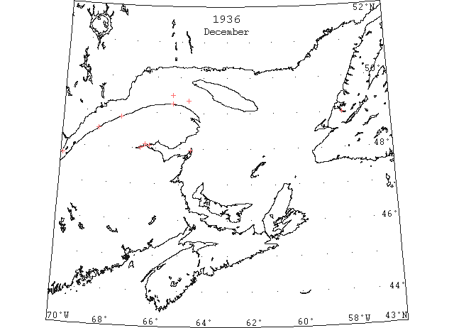
Dec 2 Crane Island, open ice everywhere. Cape Salmon, heavy pan ice everywhere. Cape Magdalen, close packed ice distant. Point Escuminac, freezing ice making fast.
Dec 2 SS “Talaralir” encountered no ice in Baie des Chaleurs until 3 miles below Dalhousie, NB; from there to Campbellton encountered heavy ice; zero weather making ice fast. (HB #2466 Dec 9, 1936)
Dec 11 Cape Salmon, heavy close packed ice everywhere. Father Point, light field ice everywhere. Cape Magdalen, light close packed ice distant. (HB #2467 Dec 16, 1936)
Dec 14 Last eastbound steamer through the Strait of Belle Isle. (WBB)
Dec 15 Last departure of the season from Quebec. (WBB)
Dec 15 Cape Salmon, heavy open ice everywhere. Father Point, no ice in sight. Matane, light close packed ice everywhere. Cape Magdalen, heavy pan ice distant. Fame Point, light close packed ice distant. (HB #2468 Dec 23, 1936)
Dec 29 J.A. Ward, Lightkeeper, Miscou Point, New Brunswick: Closing date. (CIS IC0756_3)
Dec 30 A little slob ice made in the upper part of Humber Arm on Christmas Day, but has since been broken up by the high winds and the ships. (TWS, pg. 2, Col. 3)
R.C. Butt, R.C.M.P. Patrol Boat “Louisburg”, North Sydney: On January 21st 1937 heavy slob ice off Big Bras d’or, Nova Scotia. This ice remained around the coast till it mixed with the drift ice when it came down around the early part of January. On January 26th Sydney harbour was frozen over and remained so till the end of March when it was broken by the C.G.S. Icebreaker “Montcalm”. At the present time Sydney harbour is clear of ice but the drift ice is visible off the entrance of the harbour at times. From all reports the drift ice in the gulf this spring is the worst in years. 1936 was a good year as very little drift ice was encountered off this coast. The wind seems to have the greater effect on the ice in this vicinity. Ice conditions are generally favourable around Louisburg. The channel from Scatari to the southward is quite wide, this varies of course, and is clear except with a strong easterly wind. (CIS IC1055)
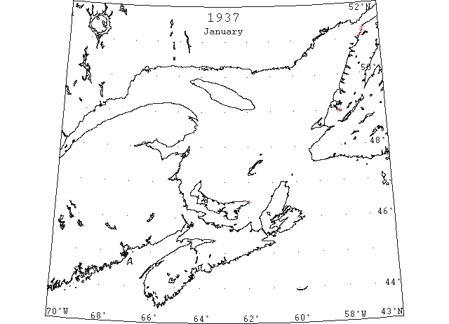
Jan 6 SS “Northern Ranger” encountered sheet slob ice in lower Strait of Belle Isle, and was unable to enter Flowers Cove, St. Barbe or Brig Bay. From Port au Choix all ports were made. (TWS, pg. 2, Col. 4)
Jan 7 G. Laing, Radio Operator, Cape Whittle, PQ: In the large bays and in the harbours, the ice seldom forms before December 20th, although in the extremely cold fall of 1933, the bays and harbours were frozen over on Dec. 13th. This fall (1936) was mild, and the bays and harbours were open until January 7th. (CIS IC0859)
Jan 9 “Montague” on January 6th, the motor vessel Gannett arrived and took on a cargo and sailed the same day. Thus a record has been made for late water shipment from this town. The river is as clear of ice as in July. (Pat 7 Jan p5 c5)
Jan 12 Georgetown – SS “Farnorth” sailed on the 12th for New York. (Pat 16 Jan p8 c3)
Jan 13 It was 10th Feb. last year that people crossed over Humber Arm on the ice the first time for the season. The hard snap of Monday made considerable ice in Humber Arm, and yesterday it extended nearly to Sprucy Point on this side, and to Meadows on the north side. (TWS, pg. 2, Col. 3)
Jan 13 Port Hawkesbury: Navigation continues open in the Strait of Canso and no snow has fallen since November, the weather exceeding all other winters for mildness and lack of usual blizzards. There is no sign of drift ice in the harbor or strait. Ponds are only slightly frozen over. A light ice harvest is feared unless a change occurs soon. (HH 14/01/1937 p14#7)
Jan 13 Inauguration flight of the Magdalene Islands’ winter air service made yesterday. (Pat 13 Jan p10 c3)
Jan 20 Lightkeeper, East Point, PEI: Ice formed in vicinity. (CIS IC0993)
Jan 20 Charlottetown Harbour still open and Fairview ferry making regular trips. Last year’s record is broken by four days to date. (Pat 20 Jan p5 c5)
Jan 27 The ice in Humber Arm is not yet anything too safe for traffic. On Sat. morning a horse went through while hauling herring ashore at Curling. The previous afternoon an ox went through while crossing from Summerside, and another horse went through off Curling on Sun. morning. (TWS, pg. 2, Col. 3)
Jan 29 Rocky Point ferry sets new record, breaking the old record of January 23rd set in 1892. On February 4, 1892, last trip of ”Elfin” from Charlottetown to Southport. “Fairview” still running. (Pat 29 Jan p1 c2)
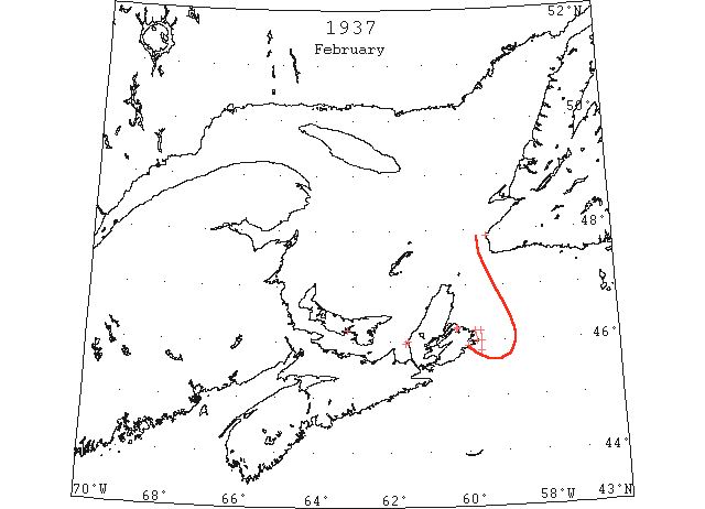
Feb Heavy ice was reported streaming out of the Gulf of St. Lawrence past Scatari Island, Cape Breton Island, on February 1,8,11 and 20. (IIP p9)
Feb 1 C.G.S. “Montcalm”: From 6 miles off Flint Island to 5 miles off Scatari, passed through heavy packed sheet ice, which extends well S of Scatarri and is drifting south-southwestward rapidly. Vessels approaching or leaving Nova Scotian ports should exercise caution, especially during darkness as this ice is very heavy. (HB #2474 Feb 3)
Feb 2 Ferry boat “Fairview” still operating. Some ice in Harbour. (Pat 2 Feb p5 c3)
Feb 4 For years the base of the United States Coast Guard, Halifax probably will greet the craft much earlier this year, because dangerous icebergs already have been sighted along the fringe of the North Atlantic steamship lane. The Coast Guard are rushing preparations of one of it earliest ice patrols, while the United States Hydrographic Office are broadcasting warnings to mariners of an iceberg 60 feet high and 200 feet long sighted 20 miles north of the ordinary westbound steamship path. Reports have been reaching the hydrographic office of existing ice conditions, the steamship “Black Tern” having reported the berg in 43°32’N 49°35’W. A smaller berg, a growler, floated in the big fellow’s wake, the report said. From other vessels reports have been received of field ice further north and heavily packed sheet ice east of Nova Scotia. (HH 04/02/1937 p16#7)
Feb 10 Vessel damaged by ice outside Sydney.
Feb 13 Frozen body found on ice floe more than a mile offshore. Had been crossing between Inter and Outer Port Hood Islands yesterday when the ice floe broke off and drifted out to sea. (Pat 13 Feb p1 c6)
Feb 15 Charlottetown Harbour ice is in an unsafe condition. Rocky Point Ferry might resume operations if mild weather continues. (Pat 15 Feb p8 c3)
Feb 17 Owing to so much ice in the Gulf the SS “Caribou” has been going to Louisburg. The last trip the ship could not make Louisburg but finally succeeded in making her way to North Sydney (TWS, pg. 1, Col. 2)
Feb 17 The ice at Codroy has been in very good condition for skating during this week. (TWS, pg. 1, Col. 3)
Feb 17 2 young men went adrift on ice clampers at Port Hood, NS. One succeeded in reaching Henry Island, 3 miles distant. The other perished, the frozen body being retrieved from the ice Fri. (TWS, pg. 2, Col. 1)
Feb 18-19 U.S.C.G.C. “Cayuga” 42°38’N 56°05’W and 43°15’N 56°50W, no ice. (HB #2477 Feb 24)
Feb 21 U.S.C.G.C. “Champlain” 43°21’N 56°37’W no ice. (HB #2478 Mar 3)
Feb 20 Cape Race: Field ice and slob ice extending SE from Flint Island to Scatari Island. (IIP p 44#118)
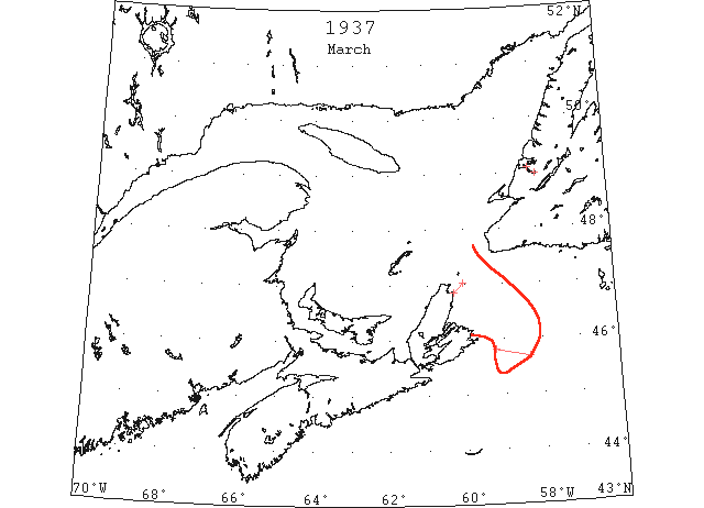
Mar Heavy field ice was reported March 28 extending 63 miles ESE from Scatari Island. This was the only report of St. Lawrence ice for the month. (IIP p10)
Mar 3 The ice has broken off at McIvers Point, giving open water at outer part of the bay . The SS “Caribou” encountered considerable ice and a storm crossing Cabot Strait from Louisburg to Port aux Basques on Thur last, which delayed her many hours (TWS, pg. 2, Col. 3)
Mar 9 “Montcalm” heavy rafted pack ice extending 10 to 15 miles off shore western side Cabot Strait. (IIP p 46#192)
Mar 17 The weather of late has been much colder than in the month of Feb., and we are again experiencing ice around the shore. So this accounts for colder weather. (TWS, pg. 1, Col. 4)
Mar 17 The SS “Caribou” encountered heavy field ice during her crossings of Cabot Strait and Sat. and Sun., each crossing occupying 12 hours. (TWS, pg. 1, Cols. 3&4)
Mar 24 The store of Baggs & Co. was broken into. Fortunately the act was discovered in time to warn the police and have the culprits interrupted on their way to Corner Brook over the ice. (TWS, pg. 2, Col. 3)
Mar 23 U.S.C.G.C. “Mendota” 43°38’N 57°15’W no ice. (HB #2482 Mar 31)
Mar 24 U.S.C.G.C. “Champlain” 43°55’N 59°12’W no ice. (HB #2482 Mar 31)
Mar 28 “Icarus” 45°49’N 59°14’W to 45°40’N 58°20’W Field ice. (IIP p 47#253)
Mar 31 The Humber River is open, with water extending almost across to Hughes Brook. (TWS, pg. 2, Col. 2)
Mar (end) Pilotage officer, Father Point: River clear of ice. (CIS IC0707)
J. Boucher, Master, SS “New Northland”, “In the last three years, (1935,’36,’37) when returning from the south, about the 28th April, the first year (1935) I had to go outside Sable Island, then nearly over to St. Pierre, Miquelon, from there to Cape Ray, then Bird Rock, then Fame Point, but in the last two years, I have met no sign of ice. (CIS IC0904)
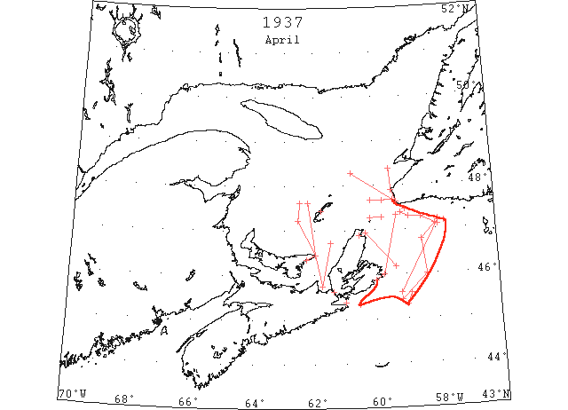
Apr St. Lawrence ice was reported throughout the month I heavy floes drifting past Scatari Island. The St. Lawrence Ice Patrol was started April 8 and discontinued May 1, when all the heavy floes had disappeared. (IIP p11)
Apr 3 Lightkeeper, East Point, PEI: Spring breakup. (CIS IC0993_2)
Apr 6 C.G.S. “Montcalm” N coast of Cape Breton blocked with heavy ice, also the E coast to about the middle. Cabot Straits packed with broken ice extending S of Scatari far enough to be seen off Canso. From Cape Ray steering 307 vessel passed through broken soft ice to 48°17’N 60°45’W; from there clear water to 8 miles 163 from Heath Point; thence steering 196 in clear water to 48°18’N 61°56’W. (HB #2484 Apr 14)
Apr 8 C.G.S. “Montcalm” : E and N coast of Cape Breton Island blocked with ice. Cape Ray to Heath Point, soft broken sheet for about half-way then open water to Heath Point, thence to 48°18’N 61°56’W, thence to 12 miles SE by E of Bird Rock. The vicinity of Cape Ray and Cape Anguille, strings of broken ice to 10 miles, 240° , from Cape St. George, where to the westward edge of eastern pack begins broken close packed ice with rafted pans through it. From 13 miles off Channel Head steering 108, in fog, passed through heavy broken ice to 47°18’N 58°52’W and open water, same course, to 47°16’N 58°28’W, then in clear weather through open scattered ice to 47°06’N 57°55’W which is SE edge of pack. (HB #2484 Apr 14)
Apr 9 C.G.S. “Montcalm”: The N coast of Cape Breton Island is blocked with heavy broken ice and also the E coast from Middle Cabot Strait extending S of Scatari. Since Apr. 3, have gone over steamer tracks via St. Pierre, Cape Ray, Bird Rock and W to 48°18’N 61°56’W and found all ice encountered over these routes soft and broken with about 80% of open water through it. (HB #2484 Apr 14)
Apr 9 The government ice-breaker “Montcalm” reported to East Coast Signal Service yesterday there was little change in ice conditions in the Gulf of St. Lawrence between Anticosti Island, Cape Breton and Newfoundland. In a message intercepted at North Sydney and relayed to Halifax the ice-breaker said: “North coast Cape Breton blocked with heavy ice, also East coast from middle Cabot Strait extending south of Scatari. Since April 3 have gone over steamer tracks via St. Pierre, Cape Ray, Bird Rock and west. Found all ice encountered over these routes soft and broken with about 80 per cent open water. Ships bound in Gulf from east or west Communicate with “Montcalm” for information regarding routes to be taken.” (HH 10/04/1937 p20#5)
Apr 12 “Montcalm” 45°25’N 59°10’W to 46°00’N 58°20’W and 46°47’N 58°28’W to 47°07’N 58°01’W field ice. (IIP p 49#344)
Apr 14 Canso: Easterly gales with rain ushered in the advanced lobster season in the district on Saturday. Sunday afternoon, drift ice could be seen less than two miles off shore rapidly approaching the harbor aided by a northerly wind. Except for a few pots put out in sheltered water, local fishermen were idle on the first day of the season. Two year ago almost half the pots in use were destroyed by ice and as a result many fishermen were unable to refit. (HH 15/04/1937 p16#8)
Apr 15 First arrival of season at Quebec. (WBB)
Apr 16 Georgetown – The harbour is now clear of ice. (Pat 16 Apr p2 c5)
Apr 16 Although the winter on the whole has been very mild still considerable ice has formed in some sections of the province, particularly around Cape Breton. The coves and bays of that island are still fast in the grip of the ice king and is proving a big deterrent to early fishing. Some herring have been taken around Baddeck but only in small quantities. (HH 16/04/1937 p14#7)
Apr 17 Lightkeeper, East Point, PEI: Clear of ice. (CIS IC0993_3)
Apr 17 Canadian Signal Service: recommended route for ships bound in Gulf from E after passing Pointe Plate, Miquelon, steer midway between Burgeo Bank and S coast of Newfoundland, thence to 6 miles off Cape Ray and 9 miles E of Bird Rock. No ice from Bird Rock to Cape des Rosiers and Quebec; considerable ice drifting down between Cape Breton and Bird Rock and may move across track between Cape Ray and Bird Rock. Ships from W should steer S and E of ice extending from E coast of Cape Breton, S and E of Scatari, to position reported 12th, 45°35’N 59°10’W, thence to eastward off Burgeo Bank and up toward Cape Ray on above-mentioned course. This ice may have drifted to S and E since last report, the ice in Strait of Canso loosening up. (HB #2485 Apr 21)
Apr 17 The 1937 shipping season opened in Charlottetown Saturday (April 17th) when the SS “Todac” arrived from Montreal. (Pat 19 Apr p8 c4)
Apr 18 Georgetown – The ferry boat “Montague” took up service on April 18th. Last year she made her first trip on the 10th. Schooner “Arcadia” to sail tomorrow for Pictou. Motorcraft Millie B. will sail in a day or so for the Magdalene Islands. (Pat 27 Apr p5 c3)
Apr 20 Grindstone, M I – Magdalen Islands surrounded with drift ice. Pleasant Bay clear. (HH 20/04/1937 p16#8)
Apr 21 Grindstone, M I – Magdalen Islands surrounded with drift ice. Pleasant Bay clear. (HH 21/04/1937 p16#6)
Apr 21 The Department of Transport, Radio Division, issued the following report on ice conditions yesterday as intercepted from the ice-breaker “Montcalm”: Recommended route for ships bound in gulf from east, after passing Point Plate, Miquelon, steer midway between Burgeo Bank and south coast of Newfoundland, thence to six miles off Cape May and nine miles east of Bird Rock to Cape des Rosiers and Quebec. Considerable ice drifting down between Cape Breton and Bird Rock and may move across track between Cape Ray and Bird Rock. Patches loose field ice reported 21st 47.40 N, 59.54 W, as far as could be seen to west and east. Field ice reported 21st 47.27 N, 58.58 W. Ships bound in gulf via Cabot Straits from west should steer south and east of ice extending from the east coast of Cape Breton south and east of Scatari to reported position 20th, 45.25 N, 59.00 W, and 45.35 N, 58.52 W, then steer to eastward of ice reported 18th extending five to ten east and three miles north of Burgeo Bank, thence towards Cape Ray on above mentioned course. Ice reported in the Strait of Canso loose and soft, George Bay considerable loose ice. Route to Quebec via Strait of Canso and East Point navigable with caution. (HH 22/04/1937 p18#8)
Apr 22 Charlottetown Harbour clear of ice. (Pat 22 Apr p12 c4)
Apr 22 Grindstone, M I – Magdalen Islands surrounded with drift ice. Pleasant Bay clear. (HH 22/04/1937 p18#8)
Apr 23 Canadian Signal Service: recommended route for ships bound in Gulf from E after passing Pointe Plate, Miquelon, steer midway between Burgeo Bank and S coast of Newfoundland, thence to 6 miles off Cape Ray and 9 miles E of Bird Rock. No ice from Bird Rock to Cape des Rosiers and Quebec. Ships from W should steer S and E of ice extending from E coast of Cape Breton, S and E of Scatari, to position reported 20th, 45°35’N 58°52’W but which may move to S and E. Then steer to eastward of Burgeo Bank and toward Cape Ray on above mentioned course. Ice now scattering in strings and patches and may be encountered drifting across any given track, but as there is ample open water and room to steer clear of it, not much difficulty should be experienced. The coast of Cape Breton ice is also loosening. Ships are navigating in and out of Sydney Harbour, the route via Strait of Canso and East Point, PEI is navigable with caution in the vicinity of Cape North and St. Paul Island. Considerable scattered and close pack ice extending 16 miles E of St. Paul Island. (HB #2486 Apr 28)
Apr 23 Grindstone, M I – Magdalen Islands surrounded with drift ice. Pleasant Bay clear. (HH 23/04/1937 p14#8)
Apr 26 Last year[1938] navigation in Humber Arm opened on 22nd Apr. and the following day the first steamer arrived. The previous year[1937] it opened 23rd Apr. (TWS 1939 p2 c3)
Apr 24 The ice report for Saturday as intercepted from the icebreaker “Montcalm” and released by the Department of Transport, radio division, follows: Recommended route for ships bound in-gulf from east: After passing Point Plate, Miquelon, steer midway between Burgeo Bank and south coast of Newfoundland, thence to six miles off Cape Ray and nine miles east of Bird Rock. No ice from Bird Rock to Cape des Rosiers and Quebec. Ships bound in-gulf from west via Cabot Straits, should steer south and east of ice extending from east coast of Cape Breton south and east of Scatarie to reported position 20th, 45.35 N, 58.52 W, but which may move to south and east, then steer to eastward of Burgeo Bank and towards Cape Ray on above-mentioned course. Ice is now scattered in strings and patches and may be encountered drifting across any given track but as there is ample open water and room to steer clear of it not much difficulty should be experienced. The coast of Cape Breton ice is also loosening up and ships are navigating in and out of Sydney harbor. Route via Strait of Canso and East Point, PEI, clear to 47.14 N, 62.33 W, to 47.38N, 62.29W, then clear water. Vicinity of Cape North and St. Paul Island, considerable scattered and close packed ice. (HH 26/04/1937 p17#8)
Apr 24 Grindstone, M I – Magdalen Islands surrounded with open drift ice. Pleasant Bay clear. (HH 20/04/1937 p17#8)
Apr 25 The steamship “Lovat” has just completed her first trip to the Magdalene Islands arriving in Souris today. She reports quite a large quantity of ice in the Gulf, but particularly between East Point and Souris. (Pat 25 Apr p5 c3)
Apr 26 The following report on ice conditions was released by the Department of Transport, radio division, yesterday: Recommended route for ships bound in gulf from east, steer from Miquelon to six miles off Cape Ray and nine miles east of Bird Rock. No ice from Bird Rock to Cape des Rosiers and Quebec. Ships bound in gulf from the west should pass south and east of ice, extending from east coast of Cape Breton south and east of Scatarie to reported position twentieth 45°35’N 58°52’W but which may have moved to south and east, then steer to eastward of Burgeo Bank and towards Cape Ray. Ships bound in via Strait of Canso steer from East Point, PEI in clear water to 47°38’N 62°13’W which is northwestern edge of ice strings. Patches of soft ice will be found north and east of that line. Ice now scattered in strings and patches and be encountered drifting across any given track but as there is ample open water and room to steer clear of it, not much difficulty should be experienced. (HH 27/04/1937 p12#4)
Apr 27 Grindstone, M I – Magdalen Islands surrounded with drift ice. Pleasant Bay have narrow strings of drift ice. (HH 23/04/1937 p12#1)
Apr 27 Back from her first trip to Montreal since the opening of navigation in the St. Lawrence river this season, the tanker “Talaralite” returned to port yesterday and docked at Imperial to load cargo. She cleared again for the river port. (HH 27/04/1937 p12#4)
Apr 28 Issue?: Charlottetown Fisheries patrol vessel “Arlewe” arrived in port yesterday and left during the afternoon. (Pat 28 Apr p5 c5)
Apr 28 Montague – The river has been open for some weeks and the first vessel arrived on Thursday (28th April). (Pat 3 May p2 c4)
Apr 28 The following ice report has been supplied by the Department of Transport, Radio Division: Recommended route for ships bound in gulf from east, steer from Miquelon to six miles off Cape Ray and nine miles east of Bird Rock. No ice from Bird Rock to Cape des Rosiers and Quebec. Ships bound in gulf from west via Cabot Strait may pass five to six miles off Scatarie then to the eastward of St. Paul Island, following the eastern edge of open ice off the east coast of Cape Breton which extend from Aspy Bay to Flint Island three to 18 miles off shore, 28th. Ships bound in via Strait of Canso steer from East Point, PEI, in clear water to 47°38’N 62°13’W which is north western edge of ice strings. Patches of soft ice will be found north and east of that line. Ice now scattered in strings and patches and may be encountered drifting across any given track but as there is ample open water and room to steer clear of it not much difficulty should be experienced. (HH 29/04/1937 p12#1)
Apr 29 Grindstone, M I – Magdalen Islands surrounded with drift ice. Pleasant Bay clear. (HH 29/04/1937 p12#1)
Apr 30 Canadian Signal Service: Ships from the E bound in the gulf may steer any desired course between St. Paul Island and Cape Ray; thence toward Bird Rocks and Cape des Rosiers. Ships bound in the Gulf from the W via Cabot Straits may pass 5 to 6 miles off Scatari, thence to the eastward of isolated pans and strings of soft ice extending off the E coast of Cape Breton, from White Point to Scatari. Ships bound in gulf via Strait of Canso after passing through the strait may steer any desired course but should be on the look out for isolated pans and strings of soft ice, and if they are encountered sufficient open water will be found in any direction to steer clear of them. (HB #2487 May 5)
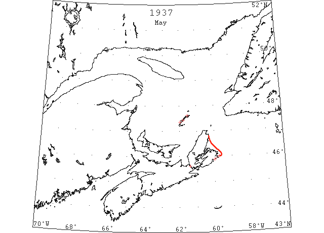
May The Straits of Belle Isle and the immediate vicinity was reported clear of ice on May 20. (IIP p11)
May 1 The following ice report has been released by the Department of Transport: Ships from the East bound in Gulf may steer any desired course between St. Paul Island and Cape Ray, thence towards Bird Rock and Cape des Rosiers. Ships bound in Gulf from West via Cabot Straits may pass five to six miles off Scatarie, then to the eastward of isolated pans and strings of soft ice extending from the east coast of Cape Breton from White Point to Scatarie. Ships bound in Gulf via Strait of Canso, after passing through the strait may steer any desired course but should be on the lookout for isolated pans and strings of soft ice and if encountered, sufficient open water will be found in any direction to steer clear of them. Souris: No ice here or at East Point, Mulgrave: some light scattered ice in strait, Port Hood: No ice in sight; Canso: No ice in sight. (HH 01/05/1937 p12#7)
May 1 Grindstone, M I – Magdalen Islands surrounded with drift ice. Pleasant Bay clear. (HH 01/05/1937 p12#8)
May 3 Grindstone – Amherst, no ice in sight; Etang du Nord, one miles of scattered ice; Grosse Isle, half mile loose ice; Pleasant Bay, clear. (HH 03/05/1937 p4#8)
May 5 The ice has cleared off the shore and fishing schooners are enabled to come into the harbor (Codroy). (TWS, pg. 6, Col. 2)
May 5 Grindstone – Amherst – No ice in sight. Etang du Nord – about one mile scattered ice, Grosse Isle – a half mile of loose ice. Pleasant Bay – clear. (HH 05/05/1937 p13#5)
May 6 Grindstone, M I – Magdalen Islands now clear of drift ice. (HH 06/05/1937 p17#2)
May 17 Sydney: Cape Breton fishermen caught 910 cwts. of fish during the month of April at a landed value of $960, according to figures released by Supervisor of Fisheries A G McLeod. Herring was the highliner when 772 cwts. brought $757. During the same month in 1936, Cape Breton fishermen caught 11,893 cwts. of fish at a landed value of $9,991. Heavy Drift Ice. The decrease is attributed to heavy drift ice along the coast especially in the vicinity of North Sydney and Ingonish where the main fishing industry is pursued during the spring months. (HH 18/05/1937 p14#8)
May 24 First Westbound steamer through the strait of Belle Isle. (WBB)
May 25 Ice has disappeared all along the east side of the Grand Banks and there is no ice in the major trans-Atlantic travel lanes. Commander Henry Coyle, of the U S Coast Guard cutter “Mendota,” declared when the ship returned to Halifax yesterday from her regular period of ice patrol duty. Commander Coyle said that the absence of ice on the east face of the banks indicated there wouldn’t be much more in that vicinity. The remainder of the ice is generally in a north easterly direction from Cape Race and there is considerable ice west and southwest of Cape Race for several miles. The commander asserted that the last report of an ice field was off the Straits of Belle Isle. He added that gales from an east north easterly direction would clear this situation. The “Mendota” encountered about 65 per cent fog on her patrol and was unable to do much scouting. (HH 26/05/1937 p14#6)