1935 Season
Nov 30 SS “Hocheloga” finished shipping season to Charlottetown yesterday. (Pat 1 Dec p8 c3)
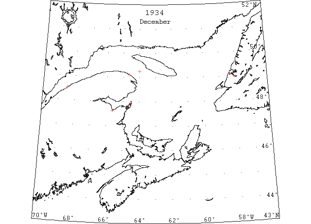
Capt. R. Geary, Marine Supt., Bowaters, Nfld: The SS “Corner Brook” left Dalhousie, in Chaleur Bay, on December 29th, 1934, bound for Corner Brook. She encountered a field of heavy ice, which had come from the St. Lawrence, in the western part of the Gulf, and in breaking her way through became jammed for 3 days. On breaking clear she found open water in the centre of the Gulf, and proceeded toward Corner Brook. She again encountered drift ice just S of the entrance to the Bay of Islands. She was able to break through this ice with some difficulty, and arrived at Corner Brook safely on January 3rd. The drift ice closed in on the whole coast, and the “Corner Brook” was unable to leave port until 20th April. This was an exceptionally early date for drift ice to arrive off the Bay of Islands. Drift ice is not as a rule sighted from the entrance to the Bay of Island until the end of January, and sometimes well into February. The earliest date of its appearance on record was January 3rd, 1934. [should this not be 1935?] (CIS IC0736_9-IC0736_10)
Dec (beginning) Pilotage officer, Father Point: Ice starts making. (CIS IC0708_2)
Dec 3 Last eastbound steamer through the Strait of Belle Isle. (WBB)
Dec 8 Last departure of the season from Quebec. (WBB)
Dec 9 Georgetown – SS “Enterprise” made her trip around from Cardigan Sunday breaking her way through river ice. Next morning people were walking on ice she had broken day before. (Pat 13 Dec p2 c5)
Dec 18 The Rocky Point ferry “Hillsboro” was closed on December 18th. (Pat 11 Jan 1936 p5 c3)
Dec 21 West Point, Magdalen Islands, Tignish, Cape Ray and Port Daniel, all have no ice in sight. St.Paul`s Island, no ice so far. Charlottetown, Bay Chaleur clear of ice. Bathurst, harbour frozen over. Dalhousie, Bay clear of ice. Shippigan, communication interrupted today. Paspediac, no ice in Bay yet. The first field ice going down was off Fame Point on the 13th. Probably down to the W End of Anticosti Island by now. (RG42 Vol.371)
Dec 26 The ice down the river extends as far as Sandy Point with a thickness from two to three inches. The hurricane gale of north-west wind which prevailed Friday broke most of the ice up, which now reaches about half mile below Mill Point. (TWS, p.2).
Dec 26 Considerable slob ice made in Humber Arm on Sunday and boats experienced difficulty in negotiating way through. (TWS, p.2).
Dec 31 J.A. Ward, Lightkeeper, Miscou Point, New Brunswick: Closing date. (CIS IC0756_3)
Jan 2 The SS “Sagona” who arrived from her last northern trip for the season on New Year’s Day, experienced very little trouble negotiating a passage through the ice in the Humber Arm. (TWS, p.1)
Jan 2 SS “Far North” left Souris on Monday with potatoes. (Pat 2 Jan p8 c3)
Jan 2 Georgetown – Ferry boat blocked on Wednesday. “Eastwood” sailed early on Monday, worried about freeze up. (Pat 5 Jan p8 c6)
Jan 5 Lightkeeper, East Point, PEI: Ice formed in vicinity. (CIS IC0993)
Jan 5 Car ferry experienced considerable difficulty with ice on Saturday. (Pat 7 Jan p8 c3)
Jan 9 People fishing for codfish the past few days ventured great risk because of the weakness of the ice and the wide channels between the sheets. (TWS, p.2).
Jan 9 The ice off Sprucy Point and other parts of Curling has been dotted the past few days with people jigging codfish. The fish have been plentiful and some good catches have been made. (TWS, p.2).
Jan 16 A sheet of ice, which broke away from the main body during a breeze of wind in the Arm on Sunday of last week, did considerable damage to the Railway pier at Humbermouth. (TWS, p.2).
It was feared that the mild spurt last week would take away the ice bridge over Humber Arm, but the change in temperature since Sunday has made it secure and people are again able to cross over it. (TWS, p.2)
Jan 16 Ice bushed from Poole’s landing to Rocky Point. Teams are travelling today. (Pat 16 Jan p5 c4)
Jan 17 It was 2 o’clock Tuesday afternoon before the train ferry “Scotia II” docked here for the morning express from Sydney. Leaving Mulgrave in a blinding blizzard at 10 a.m. she was carried down the Strait of Canso by heavy ice which filled the stream as far as the eye could see, and was being driven at a terrific rate by the tide and gale. (HH 18/01/1935 p10#5)
Jan 23 The channel made in the ice recently by the last outward bound steamers leaving this port, has been solidly cemented together the past week, and one can now cross to any part of the arm in perfect safety. (TWS, p.1).
Jan 30 The first iceboat appeared on the Humber Arm this week. There is too much snow on the ice, however, to make sailing possible. (TWS, p.2).
Jan 30 Herring continues plentiful in Humber Arm and many fishermen are catching them with nets set through the ice. (TWS, p.2).
Jan 30 The ice over Humber Arm is now firm to make traveling over it quite safe, and as a result many people are in Curling daily from out-laying settlements, resulting in increased trading business. (TWS, p.2).
Feb 7 SS “Incemore” 45°30’N 57°45’W heavy gulf ice. (HB #2372 Feb 20)
Feb 13 The drift ice is now packed tight to the land and the outer reaches of the Bay are filled. (TWS, p.2).
The SS “Kyle” has encountered considerable slob ice crossing the Cabot Strait on her recent trips. (TWS, p.2)
Feb 13 SS “Sparreholm” between 45°04’N 59°11’W and 14th in 47[45?]°57’N 57°23’W passed fields of ice. (HB #2377 Mar 27)
Feb 16 SS “Kyle” sailed for Port aux Basque with freight, passengers and mail. The “Kyle” was forced to come to Louisburg owing to ice conditions at North Sydney. (HH 19/02/1935 p11#1)
Feb 20 Several automobiles have been on the ice of Humber Arm of late. (TWS, p.2)
Feb 20 With water pouring into her hold, the grain-laden British freighter, “Homeside” is steaming for Halifax at full speed. She was damaged in drift ice, it is understood, off the Cape Breton coast. (HH 20/02/1935 p12#2)
Feb 22 Pointe des Monts, no ice in sight. Father Point, packed ice everywhere. Fame Point and Matane, heavy close packed ice everywhere as far as can be seen. West Point and Heath Point, heavy close packed ice everywhere. Grindstone, Grosse Isle, Old Harry, open ice. Etang du Nord and Amherst Island, close packed ice. Pleasant Bay, considerable light ice. Port Hood, ice blocked as far as can be seen. Elmira, heavy close packed ice all around as far as can be seen. Cape Ray, light close packed ice everywhere. Cheticamp, ice packed on shore all along this coast. Point Tupper, close packed ice. N of Port Hastings ice jam formed. St. Pauls Island, close packed ice with a few small open leads to SW and N. Broken ice and large pans with some open water to Eastward. (RG42 Vol.371)
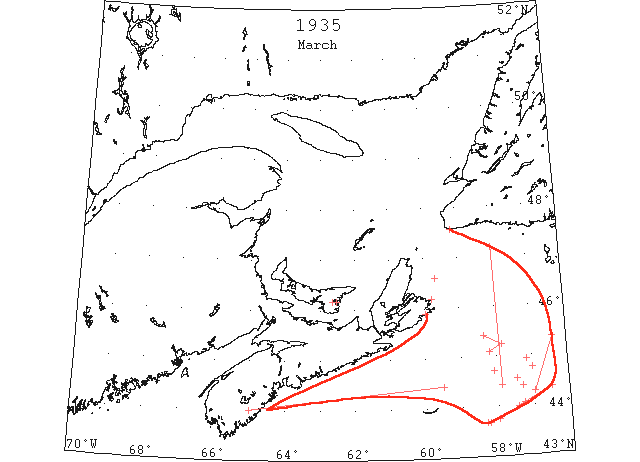
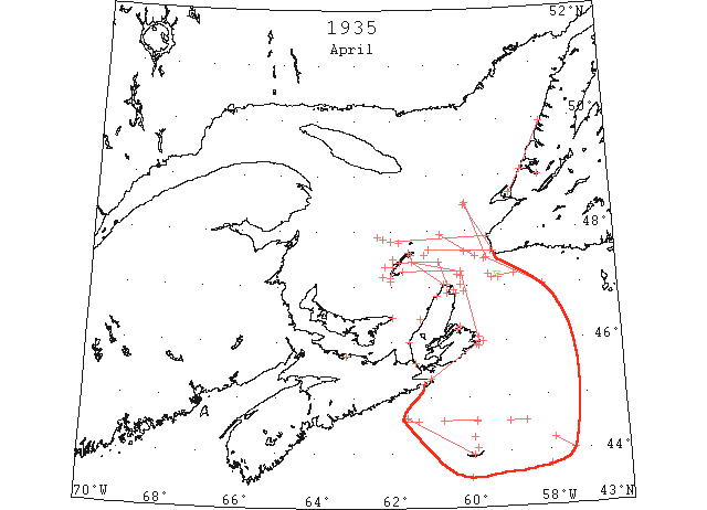
Mar The first reports of St. Lawrence ice were received in the early part of March, and by the end of the month extensive areas of heavy field ice were reported from the southern coast of Newfoundland, southward to Sable Island, and eastward as far as longitude 56°W. This ice completely blocked the Laurentian Channel and Cabot Strait. During this period, all shipping was routed south of Sable Island. (IIP p14)
Mar 4 Sydney, a 40-hour battle with heavy ice floes ended at Louisburg early this evening when the Newfoundland government steamer “Kyle” docked at the historic seaport town after one of the toughest trips experienced in her lengthy sailing career. Leaving Port aux Basques Saturday evening about five o’clock the sturdy little craft made good progress until within 30 miles of Cape Breton, but from then on passage became difficult and progress slow as heavy drift ice closed about the ship. At times the steamer was stationary, being unable to buck the jam, and was held up about 28 miles off Low Point since last night, the “Kyle” managed to edge her way slowly through the field around noon today and headed for Louisburg to drop anchor there at 5:30 this evening. (HH 05/03/1935 p1#4)
Mar 5 Vessel damaged by drift ice off Nova Scotia coast. (NYMR)
Mar 7 SS “Aladdin” from Louisburg put into St.John’s with ice damage and water in the forepeak. (NYMR)
Mar 8 Between 43°45’N 58°W and 43°41’N 58°15’W large patches of field ice SS “Rydboholm” (HB)
Mar 10 44°25’N 59°30’W to 44°00’N 65°00’[?]W Ice field (IIP p47 #67)
Mar 11 Cape Race: Field ice and growlers 44°56’N 57°10’W (IIP p47#70)
Mar 12 “Frederick VIII” light field ice 43°40’N 58°20’W (IIP p47#76)
Mar 13 Channel harbor is filled with ice and boats cannot get out fishing. (TWS, p.2).
Mar 14 47°10’N 58°00’W to 44°25’N 57°53’W Field ice (IIP p47 #83)
Mar 20 We made note a while ago regarding a Sealing Company at this point. With furtherance we might say that the net is just about completed, and those who are so enthusiastic over the matter are just waiting for the ice to move out. “Seals watch your step.” (TWS, p.1).
Mar 21 45°20’N 56°24’W to 44°17’N 56°58’W Field ice (IIP p47 #104)
Mar 22 45°25’N 58°20’W to 45°14’N 57°50’W to 45°06’N 58°12’W Southwest edge extensive field of pack ice (IIP p48 #116)
Mar 22 44°42’N 58°05’W Field ice (IIP p48 #118)
Mar 22 Georgetown – cutting ice at Lower Montague and Georgetown where it is 20″ thick. Sturgeon Channel not yet open. (Pat 22 Mar p2 c5)
Mar 25 SS “Incemore” 44°45’N 57°00’W open patches and strips of rafted field ice; 44°23’N 57°18’W field ice believed to be the southern edge of the field. (HB #2379 Apr 10)
Mar 27 The s. s. Kyle is encountering heavy sheet ice in her trips across Cabot Strait. On Sunday’s trip she was about 24 hours from Louisburg to Port aux Basques. (TWS, p.2)
Mar 27 Airmail plane from Magdalene Islands reports Gulf is packed with ice. (Pat 27 Mar p5 c5)
Mar 29 44°03’N 57°17’W Field ice. (IIP p48 #141)
Mar 29 43°58’N 57°27’W to 44°21’N 56°30’W Field ice (IIP p48 #142)
Mar 30 An impassable barrier of ice breaking into unending drifting fields and thrown in a phalanx against North Atlantic shipping lanes had last night brought steamship operators face to face with their biggest crisis in years in combating spring’s annual challenge carried down by Arctic currents. The 4903-ton collier “Coalby” and an unidentified two-masted schooner almost certainly the missing Gloucester “Arthur D Storey,” were held prisoner while a crippled freighter was being towed toward Halifax. Nova Scotia was touched by the outer edge of the ice barrier. The coast of Cape Breton was fringed with heavy field ice and it was only one mile from Louisburg, where ice conditions were severe, that the “Coalby” was captive. Hero of the rescue of the Belgian steamer “Jean Jadot,” the USCG “Mendota” cast off a tow line yesterday and surrendered the disabled freighter to the salvage tug “Foundation Franklin,” out of Halifax. Last night the tow was 50 miles south of St. Pierre and proceeding at the rate of four knots toward Halifax where she is expected to arrive late tonight. Meanwhile, the “Mendola’s” sturdy bows were shouldering aside heavy masses of ice as the cutter was being forced at full speed to where the “Arthur D Storey” was believed to be in momentary danger of having her stout wooden hull crushed in by pressing packs of ice some 70 miles further south. Victor in a duel with the ice packs, the ice-breaker “Montcalm” reached Louisburg last night from North Sydney. For several hours the powerful veteran warrior of North Atlantic ice sagas was held a prisoner near Flint Island. Scarred by a previous encounter, while on an errand of mercy earlier this month, four of her churning propellers blades were broken. Another victory was chalked up by the Norwegian steamer “Leif” at Halifax yesterday after an 18 day passage from Port Talbot. At one time the “Leif” battered her way for four miles through the barrier but was forced to retreat, losing half a day. Later on the “Leif” broke through a less hazardous ‘pass.’ The “Leif” officers confirmed wireless reports from the vessel that a schooner generally believed to be the “Arthur D Storey” was sighted 120 miles south of St. Pierre at 11 o’clock’ Wednesday morning hemmed in by ice. The schooner was not flying distress signals, it was said, and her position would be 140 miles southeast of Flint Island, Cape Breton, where the “Montcalm” was in difficulties. (HH 30/03/1935 p1#7,8; p4#6)
Mar 30 Halifax – A heavy ice barrier extends hundreds of miles across Atlantic shipping lanes. Jammed in floes about 20 miles apart off Cape Breton coast are “Montcalm” and collier “Coalby”. “Montcalm” broke 4 propeller blades while battling ice. Ice conditions in Gulf off Cape Breton coast are worst in years. Barrier extending from St. Pierre clear down to Sable Island. (Pat 30 Mar p5 c5)
Mar (end) Pilotage officer, Father Point: River clear of ice. (CIS IC0707)
J. Boucher, Master, SS “New Northland”, “In the last three years, (1935,’36,’37) when returning from the south, about the 28th April, the first year (1935) I had to go outside Sable Island, then nearly over to St. Pierre, Miquelon, from there to Cape Ray, then Bird Rock, then Fame Point, but in the last two years, I have met no sign of ice. (CIS IC0904)
Apr The great mass of St. Lawrence ice reported during March disappeared by the first of April, leaving only scattered ice fields around Sable Island. Heavy St. Lawrence ice continued to be reported, however, in the vicinity of Cape Ray. During the latter part of this month the field ice opened up sufficiently to allow vessels to pass along the Canadian Track E during periods of good visibility ion daylight hours. (IIP p15)
Apr 1 J.A. Ward, Lightkeeper, Miscou Point, New Brunswick: Opening date. (CIS IC0756_3)
Apr 3 The firm of Harvey and Co. are now preparing to cut ice, and next week a crew will be on the job. (TWS p.1)
The “Kyle” on her trip across Cabot Strait last Saturday passed quite few seals on the ice, there were twenty-five in one patch. (TWS, p.2).
Apr 3 Ice still interferes with the Cabot Strait service, preventing the SS “Kyle” from getting into North Sydney, but to use Louisburg instead. As a result the ship is considerably off schedule, resulting in inconvenience and extra expense to passengers. (TWS, p.2).
Apr 3 The SS “Kyle” reached Port aux Basques early this morning, and her train is due here shortly after noon. The Kyle on her trip from Louisburg yesterday encountered heavy loose ice and a severe snow storm. (TWS, p.2).
Apr 4 44°13’N 57°52’W to 44°01’N 57°23’W Several patches heavy ice (IIP p48 #170)
Apr 5 C.G.S. “N.B. McLean”: 9 am. Reports 18 miles NW of Fame Point. No ice sighted from Cape Dogs to present position. (RG42 Vol.371)
Apr 5 C.G.S. “Montcalm”: 9:30 am. 25 miles S 14°W from St. Pauls Island. Working through heavy close packed ice. A new batch of ice drifting around Cape North and pushing S fast. (RG42 Vol.371)
Apr 6 C.G.S. “Montcalm”: 8 am. 22 miles S mag. from St. Pauls Island. Heavy close packed ice in all directions from here as far as can be seen. (RG42 Vol.371)
Apr 6 C.G.S. “N.B. McLean”: 9 am. Position 50 miles 286° from Bird Rock. Steaming in clear water with N edge about 10 miles S. N of our line from Cap d’Espoir to Magdalens and over usual steaming track there is practically no ice to Father Point, with no ice reported from Bird Rock. This am. Conditions in western part of Gulf looks very favourable. (RG42 Vol.371)
Apr 8 C.G.S. “N.B. McLean”: 9 am 15 miles 195° from Cape Ray. From 4 pm. position yesterday (14 miles SE St Pauls Island) proceeded to 25 miles WNW from St. Pauls Island. This position is northern edge of ice extending from 10 miles off Cape North to Magdalens. Field of broken ice, close packed, drifted down off Cape Ray. Now investigating this ice. “Marissa Thorden” [ first incoming vessel of season?] yesterday morning 140 miles S of Cape Race. (RG42 Vol.371)
Apr 9 C.G.S. “N.B. McLean”: 9 am 17 miles N of Flat Point. Assisting “Montcalm” to clear water off Sydney. Heavy close packed ice extends down E coast of Cape Breton and field is about 40 miles at this position. (RG42 Vol.371)
Apr 10 Kincardine, Ont. reports the earliest navigation opening on Lake Huron for many years. The St. Lawrence River was opened to Montreal on 25th March, being two days earlier than last year. (TWS, p.1).
Apr 10 The SS “Ungava” was expected at St. John’s yesterday from the seal fishery. The ship reports numerous bedlamers, but the ice is too bad to put men out. (TWS, p.2).
Apr 10 Ice harvesting has been in progress the past month and still continues. The crop is good and there is little difficulty in getting 24-inch cubes of good clear ice. (TWS, p.2).
Apr 10 C.G.S. “N.B. McLean”: 9 am 10 miles 170° from Bird Rock. From St. Pauls Island proceeding along N edge to 15 miles NE Entry Island where we met heavy rafted ice S of this line. Ice solid to Cape Breton. “Marissa Thorden” past Fame point 4 am. No change over routes. Easterly gale coming. Should alter conditions off Scatari. (RG42 Vol.371)
Apr 10 St. Pauls Island, ice to the southwestward. Cape Ray, light open ice everywhere. Scatari, heavy open ice 5 miles distant to the E, N and S. (HB #2380 Apr 17)
Apr 10 “Montcalm” will leave North Sydney on April 10th for Magdalene Islands. (Pat 4 Apr p8 c3)
Apr 11 43°32’N 60°W a field of quite heavy ice [trawler “Wildgoose” (HB)] (NYMR)
Apr 11 C.G.S. “N.B. McLean”: 9 am. 35 miles S of Anticosti. Left N edge of ice this morning 30 miles 280° from Brion Islands. No ice sighted to present position. Ice reported this morning off Heath Point. Will investigate and proceed towards Cape Ray. No report of any incoming ships. Steamer “Marissa Thorden” passed Cape Salmon 8:30 coming in. (RG42 Vol.371)
Apr 11 Laurence McLellan, the mail courier on route No. 1 crossed the [Brule, Nova Scotia] harbour ice with [a] team [of horses] on April 11, 1935. (HH 23/03/1936 p13#7)
Apr 11 43°45’N 58°00’W a large field of heavy ice. (HB #2380 Apr 17)
Apr 12 First arrival of season at Quebec. (WBB)
Apr 12 “Tide” field ice 44°05’N 59°50’W. (IIP p49#206)
Apr 12 C.G.S. “N.B. McLean”: 8:45 am. 30 miles W of Cape Ray. Ice extends from here to Cape Ray and up Newfoundland coast to 30 miles off Cape St. George but is mostly broken, mixed with slob. “Marissa Thorden” expected to arrive Quebec about 3 pm. (RG42 Vol.371)
Apr 13 The SS “Kyle” made North Sydney on her trip last Saturday, the first time for over a month. (TWS, p.2).
Apr 13 On the way across Cabot Strait on Monday, the SS “Kyle” became jammed 52 miles off Channel and did not get clear until 10 p.m. She reached Port aux Basques early yesterday morning and the express train reached here in the afternoon. (TWS, p.2).
Apr 13 C.G.S. “N.B. McLean”: 8:45 am. 15 miles E St. Pauls Island. Situation around Cape Ray improved this morning. Large field SE coast Cape Breton now opening up and ice extends up S coast to Cape Breton to White Haven and this morning was 20 miles from Sable Island. (RG42 Vol.371)
Apr ~14 [At the start of the lobster season] Two years ago almost half the [lobster] pots in use were destroyed by ice and as a result many fishermen were unable to refit. (HH 15/04/1937 p16#8)
Apr 15 “Duchess of Bedford” field ice 44°33’N 59°50’W. (IIP p50#270)
Apr 15 C.G.S. “N.B. McLean”: 8:45 am. 20 miles 254° from Cape Ray. SE wind has driven ice to N and at 4 am. Was 20 miles 70° from Bird Rock. Proceeded down along edge to present position. 2 more steamers bound in. Do not expect much difficulty getting them through. (RG42 Vol.371)
Apr 15 North Sydney, encountering considerable ice during her passage from Port aux Basques the SS “Kyle” arrived here yesterday afternoon. (HH 16/04/1935 p12#2)
Apr 18 Canadian Signal Service: The route via Cape Race, Cape Ray, Bird Rock and Fame Point is at present navigable and ships may proceed to Father Point. The ice extends down the E coast of Cape Breton to beyond Scatari and is heavily packed on the S coast to the vicinity of Whitehead. The northern edge of the ice extends from 48°30’N 60°00’W to 10 miles SW of Cape Ray, thence to 47°N 58°W. Ships from the westward may for the present steer to pass 25 miles off Canso to 46°N 48°W thence to 47°N 58°W. The Gut of Canso is not recommended. (HB #2381 Apr 24)
Apr 18 Vessel bound up the Gulf of Saint Lawrence are requested to communicate with the Canadian government icebreaker “N B McLean” now on patrol in the gulf, giving position of any ice sighted or for special information regarding route according to a message from the Canadian Government Radio Service at North Sydney. The route via Cape Race, Cape Ray, Bird Rocks and Fame Point is at present navigable and vessels may proceed to Father Point. Ice extends down the east coast of Cape Breton to beyond Scatarie and is heavily packed on the south coast to the vicinity of Whitehead. The north edge of the ice extends from 48°25’N 60°W to 10 miles southeast of Cape Ray to 47°19’N 58°W. Vessels from the south and westward after passing Sable Island are urged to steer to a position in 46°N 57°W then to 47°09’N 58°W. The route via Gut of Canso is not recommended. (HH 18/04/1935 p1#1)
Apr 21 A year ago the ice [in the harbour of Brule, Nova Scotia] broke up unusually late on April 21. (HH 23/03/1936 p13#7)
Apr 23 Amherst – Open ice eight or ten miles from shore. Grosse Isle – Open ice as far as can see. Old Harry – Scattered ice distant. Etang du Nord – Heavy open ice. Pleasant Bay – Full close packed ice. Port Hood – Very little ice in bay. Harbor ice getting bad. Ice blocked in solid mass off here. Souris, PEI – East Point reports heavy close-packed ice on north shore and heavy drift ice. On south side no ice in sight off Souris Harbour. Mulgrave – Some scattered drift ice in Strait today. Canso – Some drift ice vicinity Canso Harbour. (HH 24/04/1935 p16#3)
Apr 23 Grosse Isle – About two miles ice in shore. Amherst – Open ice five or six miles from shore. Old Harry – No ice. Etang du Nord – North to northwest seven or eight miles close packed, west and southwest heavy close packed as far as can be seen. Pleasant Bay – Close packed ice. St. Paul’s Island – Close packed ice to south. Other points open waters. (HH 26/04/1935 p14#3)
Apr 24 The SS “Humber Arm” did not sail until Saturday, owing to the harbor being full of drift ice. (TWS, p.1).
Capt. Bert Shave arrived last week from a trip down the coast. The ice in the harbor proved no obstacle for the “Sinfonia” as she came through it in good time with Capt. Matthews ship in tow. (TWS, p.1).
Apr 24 The railway pier at Humbermouth has been damaged again this spring by the upheaval of ice. (TWS, p.2)
Apr 25 Canadian Signal Service: The route via Cape Race, Cape Ray, Bird Rock and Fame Point is at present navigable and ships may proceed to Father Point. A large body of ice occupies the southern part of the gulf with another large field eastward of 62°W and northward of the parallel 47°50’N, extending to the Newfoundland coast. The ice extends from St. Paul Island to the southeastward to beyond Scatari. The ice has moved off the coast of Cape Breton and Nova Scotia and ships may proceed to Halifax to Louisburg. Ships bound up the gulf after passing southward of this ice may steer to 45°N 58°W to 46°N 57’W thence to 47°10’N 58°W thence to a point 10 miles off Cape Ray. The Gut of Canso is not recommended. (HB #2382 May 1)
Apr 25 SS “Stuttgart” in 44°33’N between 58°35’W and 59°00’W and in 44°35’N between 59°50’W and 60°40’W and on 44°34’N between 61°20’W and 61°40’W passed ice field. (HB #2383 May 8)
Apr 27 Capt. R. Geary, Marine Supt., Bowaters, Nfld: After steaming up the Gulf in open water on the 27th April, the SS “Corner Brook” found heavy ice lying along the coast from Port au Port northward past the Bay of Islands. She attempted to break a passage through this ice and became jammed, unable to move. She then drifted with the ice from abreast of the entrance to the Bay of Islands to a position off Cow Head where, 3 days later, she broke free. When she arrived at Corner Brook she found that a small Norwegian steamer had opened the port, having steamed in open water all the way and arrived on 29th April. The ice has passed to the northward leaving the port open. (CIS IC0741_3-IC0741_4)
Apr 27 Canadian Signal Service: The route via Cape Race, Cape Ray, Bird Rock and Fame Point is at present navigable and ships may proceed to Father Point. There is a large body of ice to the northward of the parallel of 47°40’N and eastward of 61°W extending to the Newfoundland. There is another body of ice southward of a line from Entry Island to St. Pauls Island extending southeastward around Scatari. The route via Scatari is not available. The ice has moved off the coast of Cape Breton and Nova Scotia and ships may proceed to Halifax to Louisburg. This ice is reported 20 miles off the coast today with its eastern end in 44°38’N 61°36’W. Patches from this field were reported yesterday in the vicinity of Sable Island. Ships bound up the gulf after passing southward of this should steer to a position 45°N 58°W thence to 46°N 57°W to 47°N 58°W. The Gut of Canso is not recommended. . (HB #2382 May 1)
Apr 27 Amherst – Open ice about four miles from shore. Etang du Nord – From north to west about seven or eight miles close packed ice. Southwest heavy close packed as far as can be seen. Grosse Isle – About two miles ice in shore. Old Harry – No ice in sight. Pleasant Bay – Narrow strip of ice on south side. Souris – East Point reports heavy close-packed ice with some open water showing on south side. East and west of Souris for twelve miles clear of ice. Port Hood – Ice conditions same. Mulgrave – Some loose scattered ice in Strait. Canso – Some ice in harbor and scattered pieces in vicinity of Cranberry Light. Also some scattered ice in bay. (HH 27/04/1935 p21#7)
Apr 28 47°13’N 59°25’W Scattered pieces field ice. (IIP p53 #508)
Apr 28 47°09’N 59°20’W to 47°12’N 58°45’W Loose field ice. (IIP p53 #509)
Apr 28 “Montcalm” small growler 47°12’N 59°10’W. (IIP p53 #510)
Apr 28 47°30’N 59°30’W Scattered field ice (IIP p53 #515)
Apr 30 Grosse Isle – Scattered ice distant. Old Harry – About half mile ice in shore. Etang du Nord – Strip of heavy ice about five miles. Amherst – Ice about four miles from shore. Pleasant Bay – Scattered ice. Mulgrave- A little loose raft ice in Strait. Souris – No ice in sight. Northerly wind. Canso – Some loose ice in Chedabucto Bay. East Point – Heavy close packed ice in all directions except inshore on the south side. St. Paul’s – Distant ice to southward. Open water other points. (HH 30/04/1935 p14#1)
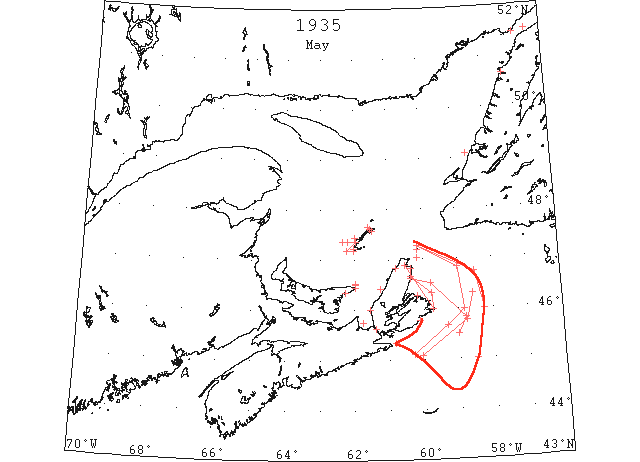
May During the month, St. Lawrence ice completely disappeared except for patches of field ice in the vicinity of Cape Breton, and all the Canadian steamer lanes from Cape Race westward through the Gulf of St. Lawrence were open. (IIP p16).
May 1 Held fast in the ice for more than 24 hours, the crippled British steamship “Titania” still awaited help today as the Newfoundland sealer Imogene sped to her rescue. The “Titania”, when she struck the ice, was bound from her home port of Newcastle, Eng., for Alfred, Que., with a cargo. (TWS, p.1).
May 1 The ice on Humber Arm melted out over the weekend. (TWS, p.2).
May 1 On Saturday the ice on Humber Arm suddenly broke up and drifted down the Bay. (TWS, p.2).
May 1 Lightkeeper, East Point, PEI: Spring breakup. (CIS IC0993_2)
May 1 Amherst – Open ice three miles from shore. Grosse Isle – About four miles open ice. Old Harry – No ice. Pleasant Bay – Light open ice. (HH 01/05/1935 p12#1)
May 1 Last year the first trip [of the SS “Lovat” to the Magdalen Islands from Pictou, Nova Scotia] was made on May 1. (HH 09/04/1936 p13#6)
May 2 Louisburg Broadcast: Ships bound up the Gulf from the eastward should steer to pass 12 miles off St. Pierre to 10 miles off Cape Ray, thence to 5 miles off Bird Rocks thence to Fame Point. Ships from the southwestward should pass S of a body of ice reported between the S coast of Cape Breton and Sable Island, then follow the easterly edge to Newfoundland coast between Cape Ray and Channel head. Caution should be observed during darkness as strings and patches of ice may be met on these routes. The ice reported on May 1 was in 45°04’N 60°04’W, 45°47°N 58°45’W, 46°18’N 58°34’W. A strong W wind is drifting the ice off the eastern coast of Cape Breton today toward the centre of Cabot Strait. (HB #2383 May 8)
May 2 Amherst – Light open ice in shore. Etang du Nord – Strip five miles wide of heavy ice about four or five miles off shore. Pleasant Bay – Large body of open ice moving east. St. Paul – Loose slob ice all directions. Visibility poor about four miles. (HH 02/05/1935 p14#2)
May 3 Amherst – Light open ice in shore. Etang du Nord – About ten miles ice off shore. Grosse Isle – Loose ice along shore. Old Harry – No ice. Pleasant Bay – No ice. Port Hood – Very little ice in bay. Harbor ice getting bad. Ice blocked in solid mass off here. Strong southwest winds. Mulgrave Strait – Comparatively clear of ice. East Point – Ice moving slowly off north shore. Heavy drift ice south shore. Souris – Scattered drift ice. Canso – No ice in bay or vicinity. St Paul – Very little loose slob ice all points. (HH 03/05/1935 p22#2)
May 4 Mulgrave – Strait clear of ice. East Point – Ice about five miles off north side. Canso – No ice in sight. Amherst – Open ice about a mile from shore. Etang du Nord – West and southwest heavy open ice as far as can see. Northwest and north four or five miles, close packed ice inshore. Grosse Isle – About half mile close packed ice around shore. Old Harry – No ice. Pleasant Bay – No ice. St. Paul Island – Close packed slob ice to south. Loose slob other points. (HH 04/05/1935 p19#5)
May 6 Amherst – Open ice about three miles from shore. Etang du Nord – One to two miles broken ice inshore. None elsewhere. Grosse Isle – About half mile ice inshore. Old Harry – No ice. Pleasant Bay – No ice. East Point – Ice on north side. Open water three miles out. South side clear of ice. Souris – No ice here. Mulgrave – No ice in strait. Port Hood – Some open strips of water in bay. Ice packed in north of here. Canso – No ice in sight. (HH 06/05/1935 p12#3)
May 8 Grosse Isle – About quarter mile ice inshore. Amherst – About one mile in shore. Etang du Nord – One quarter to one mile light open ice. None elsewhere. Mulgrave – Considerable heavy drift ice in sight. Port Hood – Bay full of scattered ice packed in solid here. (HH 08/05/1935 p14#6)
May 9 Louisburg Broadcast: Ice extends from St. Pauls Island to 46°45’N 58°30’W thence to 46°00’N 58°15’W to 45°00’N 58°30’W and toward Sable Island. Ships from the southward and westward bound up the gulf after passing southward of this steer to 45°00’N 58°15’W thence to 47°00’N 58°15’W.; thence to 10 miles northward of St. Pauls Island. Northumberland Strait is at present clear from Cape George westward, but ice has drifted down in George Bay and Gut of Canso and this route is not recommended. Sydney Harbour is clear, but heavy close packed ice extends from Cape North to Scatari. Bay Chaleur, Gaspe, and Saguenay River are now clear. (HB #2384 May 15)
May 9 Amherst – About one mile open ice in shore. Grosse Isle – About quarter mile ice inshore. Etang du Nord – About two miles wide scattered ice. Port Hood –Ice packed in harbor and bay and north of here. Mulgrave – Considerable loose heavy drift ice in strait. Canso – A little loose drift ice in bay and east of Cranberry Light. (HH 09/05/1935 p14#1)
May 9 The chilly waters of the North Atlantic along the coast of Nova Scotia yesterday claimed the life of one fisherman, a native of Lunenburg, and added another victim to the rapidly growing list of ships that have been stranded upon rock-fanged shores. Last night the British freighter “Langeeridge” out of Louisburg for Montreal, lay hard and fast on Bull Rock, a mile from Guyon Island, off the coast of Cape Breton Island, surrounded by close-packed ice floes and with her bottom badly ripped and taking water in one and two holds. While the freighter’s captain and crew of 26 appeared in no danger, the ice-breaker “N B McLean” was rushing to the rescue with order to stand by in event of emergency. The “Langeeridge” left Louisburg yesterday morning with a large coal cargo for Montreal. Ice forced the collier as far inshore that she grounded a mile northwest of Guyon Island. Later the ice packed heavily about the stranded ship and lessened the chances of a quick escape from her imprisonment. (HH 09/05/1935 p1#8; p4#7)
May 11 Etang du Nord – Scattered ice distant. Old Harry – About two miles scattered ice. Port Hood –Ice packed in harbor and bay and north of here. Mulgrave – Considerable heavy drift ice in strait. East Point – Heavy close packed on north side. Souris – Heavy drift ice outside harbor here. Canso – Heavy ice on the horizon, approximate mouth of Chedabucto Bay, from eastward. (HH 11/05/1935 21#6)
May 15 The SS “Sagona” sailed yesterday evening taking up the North-West coastal service. The ship is not expected to get north beyond Port Saunders this trip, because of ice conditions as reported in Straits Belle Isle. (TWS p2)
May 15 Louisburg Broadcast: Ice extends from St. Pauls Island to 46°50’N 59°00’W to 46°00’N 58°50’W to 45°40’N 59°20’W and along the S coast of Cape Breton extending about 25 miles offshore with the extreme SW edge in 45°06’N 60°18’W and with the northern edge 10 miles offshore. Ships from the westward may pass inside this ice to Louisburg. Ships from the eastward bound to this port should keep to the southward of this ice and around its western edge. Ships bound up the gulf should pass southward and eastward of this ice thence to a point 5 miles off Bird Rocks. Northumberland Strait is clear but some ice is in George Bay. This route may now be navigated with caution.. North Sydney Harbour is clear but heavy close packed ice remains outside and this route is not navigable at present without the services of an ice breaker. Icebreaker is assisting ships into Sydney. (HB #2385 May 22)
May 15 Louisburg: The Port of Louisburg presents a busy appearance these days. On Monday there were twelve steamers in port, some for cargo and others for bunker. Ice conditions east of Scatarie are such that ships are unable to enter Sydney Harbor. Should the wind hold from the north east it will be some days before vessels can enter Sydney. (HH 16/05/1935 p14#3)
May 15 Port Hood – Bay on Cape Breton side clear. Ice moving out north. Mulgrave – Some heavy drift ice in strait, mostly on eastern shore. East Point – Heavy ice on north side. (HH 15/05/1935 15#3)
May 17 St. Paul’s Island – Distant to south. Elsewhere open water. East Point – Heavy close-packed ice on north and south side. Souris – Light scattered ice off here. Heavy northerly wind. Port Hood – Harbor on Cape Breton side clear of ice. Packed in on Nova Scotia side. Moving out north here. Easterly wind. Mulgrave – A little loose ice in Strait. (HH 17/05/1935 p12#2)
May 19 Lightkeeper, East Point, PEI: Clear of ice. (CIS IC0993_3)
May 20 Nearly 5000 lobster traps valued at nearly $15,000 are a total loss and Nova Scotia fishermen unable to finance further a new set of fishing gear and equipment face a cheerless and profitless year, as ice continues to crush the coast in a relentless grip. At Dover, Halifax county, fishermen have lost some 1500 traps and will lead Nova Scotia fishermen’s plea for an extension of the lobster fishing period, at present opening in different sections from April 20 to May 15 and lasting two month. The eastern section of the province is worst struck. Ice conditions are very bad. In some districts fisherman have been unable to set traps since the season opened two weeks. A coast free of ice one day may be held in an iron grip by rapidly moving drift ice the next. (HH 20/05/1935 p16#5)
May 20 The lobster fishing season … was delayed on account of unusual ice conditions and fishing did not become general before 20th May. (Pat 28 Dec p7 c4)
May 22 After a long and unpleasant winter we were visited the past week by Arctic ice, brought up the run by the prevailing east and north-east winds, and passed on into Norris Arm. This is a very unusual thing for this port. We understand that Green Bay is blocked with the same. Several ships are on their way to this port, and unless a change of weather takes place, they will find it very difficult to reach here. The weather is still very cold, making it very difficult for people to do gardening. (TWS, p.1).
May 22 The schooner, “Marion Elizabeth” arrived from St. John’s on Sunday with a cargo of oil for the Imperial Oil Co. Captain Hollett encountered considerable ice when coming in the Gulf. He sighted the Gloucester schooner “Elmer E. Gray” in the ice some distance off Bay of Islands, and one or two other schooners. The SS “Fernfield” went in to Port au Port. (TWS, p.2)
May 22 St. Paul – Distant ice southward. Open water elsewhere. (HH 22/05/1935 p16#2)
May 23 Louisburg Broadcast: The Gulf of St. Lawrence is practically clear. The ice today is confined chiefly to an area from Cape Smoky to a point 20 miles N of Flint Island, thence to 45°50’N 58°48’W to 45°30’N 59°00’W and to the Cape Breton coast. Sydney Harbour is clear to Cranberry Head with soft open ice extending 10 miles N of Flat Point. (HB #2386 May 29)
May 26 J.J. Timmins, Lightkeeper, Cape St. Lawrence, N.S.: Latest breaking up [range?]. (CIS IC0814)
May 26 North Sydney, the following message was intercepted from the “N B McLean” Saturday, Gulf of Saint Lawrence now clear, the only ice of any consequence is that situated along the east coast of Cape Breton from Flat Point eastward around Scatarie, extending to southward. Sydney Harbor is clear with a strip of soft broken ice about two miles wide off the entrance. Ships from the south and west bound up the Gulf may steer from 44°33’N 61°30’W to 45°10’N 58°30’W to 46°40’N 59°00’W to 15 miles north of Saint Paul. All other routes practically clear of ice. Owing to absence of ice in the Gulf patrol will be discontinued shortly. (HH 27/04/1935 p12#2)
May 29 Point Amour, heavy close packed ice everywhere moving W; numerous bergs and growlers. (HB #2387 Jun 5)
Jun 4 Point Amour, heavy close packed ice everywhere; numerous bergs and growlers. (HB #2388 Jun 12)
Jun 12 Point Amour, heavy open ice everywhere, numerous bergs and growlers. (HB #2389 Jun 19)
Jun 19 Point Amour, numerous bergs and growlers. (HB #2390 Jun 26)
July 3 First Westbound steamer through the strait of Belle Isle. (WBB)