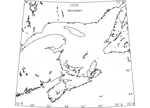
1933 Season
W.J. Balcom, Master, C.G.S. “N.B. McLean”: The Gulf of St. Lawrence is more or less covered with ice and navigation in the western part is closed (except for icebreakers and ships strengthened and having good power.) After approximately January 10th each year, but there have been exceptional years such as 1929 and 1933 when navigation closed for ordinary ships early in December. (CIS IC0728)
Nov 28 Last eastbound steamer through the Strait of Belle Isle. (WBB)
Dec (beginning) Pilotage officer, Father Point: Ice starts making. (CIS IC0708_2)
Dec (early) Port of Summerside recently closed. A very successful shipping season. (Pat 15 Dec p5 c1)
Dec 13 G. Laing, Radio Operator, Cape Whittle, PQ: In the large bays and in the harbours, the ice seldom forms before December 20th, although in the extremely cold fall of 1933, the bays and harbours were frozen over on Dec. 13th. (CIS IC0859)
Dec 19 C.G.S. “McLean”: 3 pm. Abeam Cape Salmon. Heavy close packed ice. Have difficulty with ice. (RG42 Vol.371)
Dec 19 Ships still arriving in Charlottetown. (Pat 19 Dec p5 c3)
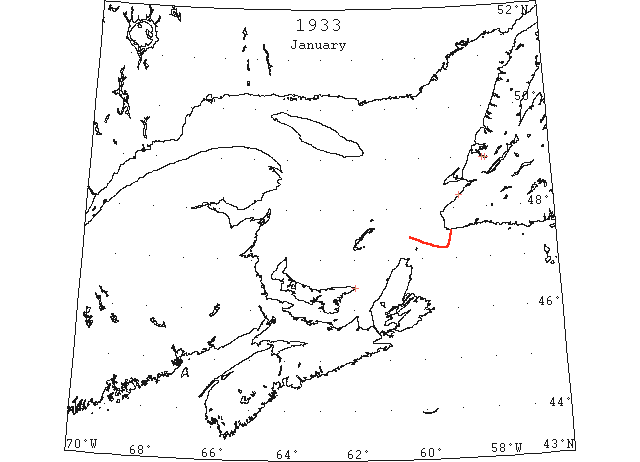
Dec 20 More or less ice all way from Quebec to Fame Point. (RG42 Vol.371)
Dec 22 Last departure of the season from Quebec. (WBB)
Dec 22 C.G.S. “McLean”: 12:45 pm. Passed Cape Salmon, open and scattered soft ice with few large sheets from Middle Ground to here. (RG42 Vol.371)
Dec 23 C.G.S. “McLean”: 9 am. 5 miles W of Bic. Left “Cairndhu” midnight off Pointe des Monts and is now in vicinity of Fame Point in clear water. Ice conditions good. (RG42 Vol.371)
Dec 23 J.A. Ward, Lightkeeper, Miscou Point, New Brunswick: Closing date. (CIS IC0756_3)
Dec 23 Still shipping from Charlottetown Harbour. (Pat 23 Dec p5 c6)
Dec 23 Ice on Summerside Harbour and Bedeque Bay is quite thick. (Pat 23 Dec p4 c5)
Dec 30 Owing to mildness of weather, summer steamer SS “Lovat” to make another trip to collect mail for Magdalenes. Air service to Magdalenes probably delayed for a fortnight. (Pat 30 Dec p4 c1)
Dec 30 SS “Lovat” left today from Souris, on a special trip to Magdalene Islands and return. (Pat 30 Dec p8 c3)
Jan 11 The little slob ice which made in the Humber Arm on Sunday was all taken out again Monday night and the Arm is again free of ice as in midsummer. (TWS, p.2).
Jan 11 The SS “Geraldine Mary” arrived from London, Tuesday night, Jan. 3, after a very trying and stormy passage of 14 days. In conversation with Captain Whemister, we were informed that it was the stormiest passage experienced by him during the many years coming to this port. In nearing the Coast he encountered about 80 miles of heavy slob ice presumed to be northern slob. (TWS, p.2).
Jan 18 Men crossed over the ice in Humber Arm, from Summerside to Curling yesterday morning, for the first time this season. The ice, though frail, extends out to beyond Meadows. (TWS, p.2).
Jan 19 Lightkeeper, East Point, PEI: Ice formed in vicinity. (CIS IC0993)
Jan 25 The mild weather and absence of snow has somewhat retarded the progress of those who have wood and hay to haul, and the recent fall of snow was indeed welcome. The ice in Robinson’s River is quite thick, and on Sunday afternoon, a number of the boys took advantage of the smooth places, to enjoy a few hours skating. (TWS, p.1)
Jan 31 CGS “Montcalm” sails from North Sydney today for the Magdalene Islands. This is the second trip of steamer this month, the first one being from Souris, because owing to exceedingly mild weather, there is not sufficient ice formed at Magdalene Islands to allow the aeroplane to make her proposed trip. (Pat 31 Jan p8 c4)
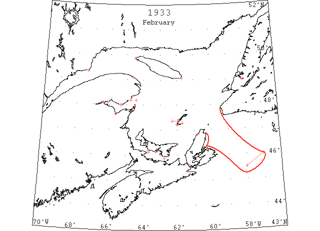
Feb St. Lawrence ice was reported to extend from lat. 46°N, lon 57°W in a southwesterly direction to 45°30’N 58°W. (IIP p13)
Feb 1 Number of young people took advantage of the ice on the Arm to have a skate. The ice, however, is nothing to firm and to this date no person has ventured to put a team on it. It extends only half down the Arm, and there is also clear water at Humbermouth. (TWS, p.2)
Feb 4 Unfavourable weather conditions are holding up the air mail trip to the Magdalenes but it is expected if the weather is fine, the plane will leave tomorrow. (Pat 4 Feb p5 c3)
Feb 7 Fame Point, heavy close packed ice everywhere. Point Maquereau, light open ice in shore. West Point, heavy open ice everywhere. Heath Point, St. Paul Island and Flat Point, all no ice in sight. Bathurst, harbour and bay frozen over, surface covered with snow. Dalhousie, ice open below Magausha. Shippegan, Miscou Point reported blocked with ice this morning. Grosse Isle and Old Harry, no ice in sight. Amherst Island, loose ice. Etang du Nord, light ice as far as can be seen. Pleasant Bay, narrow strip of ice extending from Amherst Island to Entry Island. Carleton, ice formed since yesterday but will probably go out as usual first easterly gale with next high tide. Paspediac, not much ice here; only loose ice. (RG42 Vol.371)
Feb 8 On Saturday a team crossed over from Summerside to Curling on the ice. This we believe was the first for the season. On the north side of the Arm there is only about two miles of ice, extending from Crow Head to Davis Cove. On the south side the water extends inside Child’s Point. At Meadows and the outer parts of the Bay people can move about by boat just as in the “good old summer time.” (TWS, p.2).
Feb 8 Point Maquereau, light open ice in shore. Pointe des Monts, heavy close packed ice everywhere. Heath Point, heavy open ice everywhere NE. St. Pauls Island and Flat Point, no ice in sight. Shippiegan, full of ice along Miscou point. Bathurst, ice conditions unchanged. Dalhousie, ice solid (crossing with teams). New Carlisle, bay full of ice. Carleton, ice all gone during night. Chandler, bay packed with drift ice. Paspediac, channel well clear of ice here; only loose ice seen. Grosse Isle and Old Harry, no ice in sight. Amherst Island, close packed ice. Etang du Nord, open ice. Pleasant Bay, considerable slob ice. (RG42 Vol.371)
Feb 9 Fame Point, heavy open ice everywhere. Point Maquereau, light open ice distant. Pointe des Monts, St. Pauls Island, Cape Ray and Flat Point, no ice in sight. Dalhousie, ice solid. Shippegan, ice still along shore. Chandler, ice solid in Bay this morning. Carleton and New Carlisle, no ice in bays. Grosse Isle and Old Harry, no ice in sight. Amherst, close packed ice. Etang du Nord, light ice distant. Pleasant Bay, scattered open ice. (RG42 Vol.371)
Feb 9 Port Hawkesbury, the mildness of the present winter and the absence of ice in the harbor and Strait of Canso, is a much discussed topic here, particularly among the older generation. In former years, drift ice from the Gulf of St. Lawrence always jammed this harbor, seldom arriving later than the last of January and closing navigation until April. This year no ice was visible before February 6, when the harbor filled with light ice, but this was driven away by the high winds of last night. The car ferry “Point du Chene” was today again making regular trips between here and Mulgrave after being tied up for the past three days. (HH 11/02/1933 p17#6)
Feb 10 After being held fast in ice 3 miles off Borden yesterday afternoon and all last night, the car ferry “Charlottetown” broke through and docked this morning at 5 o’clock. Heavy ice has appeared in Northumberland Strait this year earlier than usual. Its presence was probably due to high wind of last few days. (Pat 10 Feb p1 c6)
Feb 13 Government icebreaker “Montcalm” was engaged yesterday and today breaking up ice at entrance to Sydney Harbour. Ice barrier has not attained great thickness so far, a depth of only four or five inches being encountered. (Pat 14 Feb p1 c4)
Feb 16 Heavy drift ice driven by prevailing westerly winds into passage between Borden and Tormentine occasioned a delay of four hours in the crossing of the car ferry yesterday evening. (Pat 17 Feb p8 c3)
Feb 20 Cape Race: Ice 1 miles broad in NW direction 45°15’N 58°05’W. (IIP p19#8)
Feb 22 Cod fishing through the ice in Humber Arm has become quite popular lately. Several fine fish were secured by parties on Monday. (TWS, p.2)
Feb 22 So far this season, the harbour of North Sydney has remained open, an unprecedented occurrence. (Pat 22 Feb p1 c6)
Feb 23 Cape Race: Field ice 45°30’N 58°00’W to 46°00’N 57°00’W. (IIP p19#10)
Feb 28 Prevailing mild weather, ice in Charlottetown Harbour broken up and unsafe to cross. (Pat 28 Feb p8 c3)
Feb (end) Pilotage officer, Father Point: River clear of ice. (CIS IC0707)
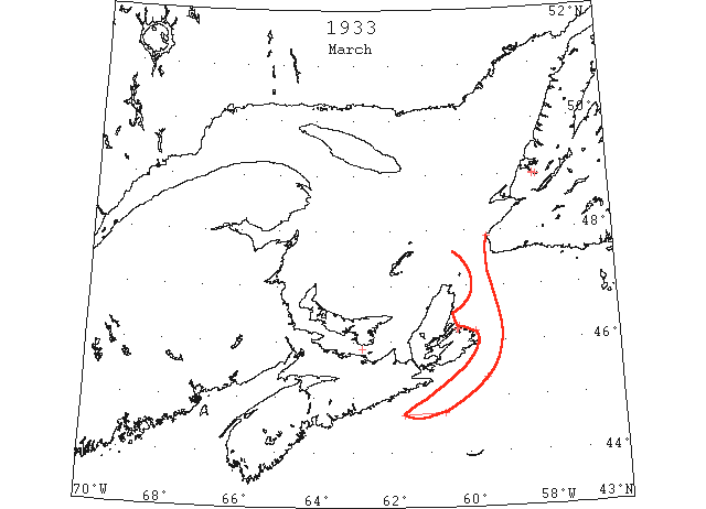
Mar St. Lawrence ice was reported about 45 miles south-southeastward from Cape Breton. (IIP p14)
Mar 2 Georgetown – ferry March 2nd (Pat 7 Apr 1934 p7 c7)
Mar 6 Clear water in harbour to Rocky Point. Earliest trip by rowboat from Rocky Point in memory of old timers. (Pat 6 Mar p6 c4)
Mar 8 Many of our people have been engaged harvesting ice the past week or so. The ice this year is not of a good quality. In many instances it is less than ten inches. (TWS, p.2).
Mar 8 On her trip out from North Sydney the SS “Caribou” had to force her way through slob ice to Cranbery Head, which delayed the ship about three hours, so that the express from Port aux Basques did not reach Curling until Friday morning. (TWS, p.2).
Mar 8 Because of the presence of ice in Sydney Harbor, the SS “Caribou” went to Louisburg on her last trip on Sunday. (TWS, p.2).
Mar 8 The SS “Caribou” was also delayed Thursday by ice. The last trip the steamer had to go to Louisburg owing to Sydney Harbor being full of ice. (TWS, p.2).
Mar 15 On Wednesday Belle Isle reported sighting two sealing steamers in sight. Heavy open ice moving west scattered seals. (TWS, p.1).
Mar 15 Due to the hard snap the past few days we now have more ice in the Humber Arm than at any time during the winter, and it now extends to beyond Meadows. (TWS, p.2)
Mar 17 CGS “Montcalm” will sail on Tuesday next for the Magdalenes. Last mail flight today or Saturday. (Pat 17 Mar p8 c4)
Mar 20 Cape Race: Large field of ice 45°20’N 59°30’W. (IIP p19#24)
Mar 22 The Canadian icebreaker reports no ice at the Bird Rocks, St. Paul’s Island or the Magdalan’s. And the only ice reported in the St. Lawrence Gulf is in Northumberland Straits. (TWS, p.1).
Mar 22 On Sunday the drift ice was in to the land at Codroy. (TWS, p.2).
Mar 23 “Frederick VIII” passed along edge of heavy packed ice extending as far as could be seen 44°43’N 60°37’W to 44°40’N 61°40’W. (IIP p19#34)
Mar 27 Glace Bay, the mystery of Flint Island which has defied all efforts of solution for more than 50 hours, tonight was further obscured by a raging snowstorm that cut off from the mainland view the lonely lighthouse rock and the secret of mysterious fog horn, flag and red light signals shown at intervals since early yesterday morning. Even if the storm lifts, it will be at least twelve hours more before a round trip to the Island can be made. The ice-breaker “Montcalm,” which started from North Sydney again at noon, made no progress and instead was carried in close to Point Edward in Sydney Harbor, where she lay all day practically helpless in grip of storm and Arctic floes. At Port Morien, the other rescue base, it is hoped that tonight’s high wind will either open the mile and a half channel to the island or pack the ice tighter, either movement making a visit possible. Morein’s rescue effort failed this morning. There was not enough water to float the boat and too much to drag it across the ice and the attempt was abandoned. (HH 28/03/1933 p1#7,8)
Mar 28 Glace Bay, March 28 – One of the nine children of Light Keeper John D Martell is dead on Flint Island. That is the meaning of horn, flag and light signals coming from the icebound rock, one and a half miles off Port Morien since early Sunday morning. The ice breaker “Montcalm” is leaving North Sydney at midnight in hopes of making Flint Island about daybreak, as reports say the pack is loosening up on the seaward side of the island. As the shore people attempted to get into communication with the Island’s 11persons this afternoon the wind which had packed ice tightly about the locality for three days had shifted and was moving the floes offshore. (HH 29/03/1933 p1#1,2 ; p4#3)
Mar 29 Nets set through the ice off Curling have kept the local market supplied with fresh herring the past week. (TWS, p.1).
Mar 29 Seals have been numerous in Bay of Islands the past few days and on Saturday many were seen in Humber Arm in to the edge of the ice, and several were shot. (TWS, p.1).
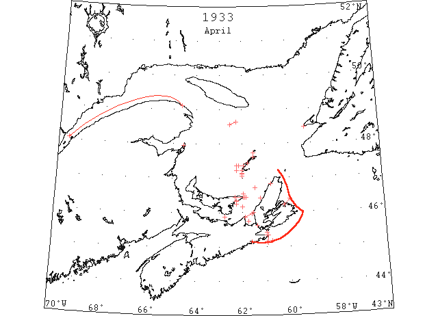
Apr 3 C.G.S. “McLean”: 9 am. 30 miles 333° from Bird Rock. No ice in sight. From 5 pm. Position saw no ice until 48°34’N 62°32’W where we met ice field. Stopped till daylight, then proceeded to 25 miles S of South Point, Anticosti, which is NW point of ice, thence to present position in clear water. “Montcalm” in Sydney reports Sydney blocked and ice along E coast Cape Breton to 15 miles off shore. Indications are we have a clear route from Cape Ray to Southwest point, Anticosti, and section from Fame Point to Red Isle is the worst at present. (RG42 Vol.371)
Apr 3 Chedabucto Bay clear of ice as far as can be seen. Canso harbour filled with ice and extending southeastward between Cranberry Gap and Glasgow Head. (RG42 Vol.371)
Apr 4 Port Hood harbour and S of islands full of ice, none in sight N of here. Souris East point surrounded by ice as far as one can see apparently heavy ice extending in straits past Souris; navigation except by ice breaker impossible. Mulgrave, large quantities ice towards Cape Porcupine; practically clear at S end straits. Canso harbour full of ice. (RG42 Vol.371)
Apr 5 Spring-like weather has come in with April, which is making itself felt upon the ice and snow. (TWS, p.2).
Apr 5 The “Caribou” on her last trip across Cabot Strait had to go to Louisburg because of Sydney Bight being filled with heavy ice. (TWS, p.2).
Apr 5 Mulgrave reports some drift ice through straits quite close packed at northern end. Port Hood clear of ice S and N of here except a little in harbour. Souris ice conditions unchanged. Canso harbour filled with ice but moving north easterly; narrow strip of loose ice along shore line between Cranberry Light and as far as can be seen southward. (RG42 Vol.371)
Apr 5 Canso – Lot of drift ice. Grindstone,– Magdalen Islands surrounded by drift ice. (HH 05/04/1933 p11#5)
Apr 6 Mulgrave reports far as can see mostly clear some loose strings ice. Souris, large body ice off shore East point; no ice in sight Souris. Canso, thin strips slob ice between Glasgow Head and Cranberry. Light strip in Chedabucto Bay. Ice from Canso side to approximately half way across bay and N as far as visible. From station. Arichat side of bay open water. From Cranberry Light long strips of slob ice to horizon. Port Hood, N winds brought ice back; bay full of ice. (RG42 Vol.371)
Apr 7 Canso, some loose ice in Canso harbour; strings of loose slob ice extending seaward between Cranberry and Glasgow Head eastward. Chedabucto Bay clear of ice. Mulgrave, far as can see strait clear of ice. Souris East Point reports N shore jammed with ice extending for miles westward along shore; S side clear. Port Hood, bay full of ice N of here and around shore of Cape George along shore S of here clear of ice. (RG42 Vol.371)
Apr 7 SS “Valfiorita” reports bound Quebec from St. John, NB, met broken and ice field extending from Whitehead to Cape Canso and 10 miles off shore. (RG42 Vol.371)
Apr 7 Canso – Lot of ice in sight. Grindstone, Magdalen Islands – Drift ice ten miles off shore at West Point. No ice in sight at Etang du Nord. Drift ice at Grosse Isle and in Pleasant Bay. (HH 07/04/1933 p13#3)
Apr 7 Drum Head, residents of this place were surprised when a field of gulf ice came in to find that about 200 seals were enjoying their visit. Men secured guns and boats and within two or three hours some thirty or forty seals were landed. This is the first time that seals were on gulf ice here, according to the oldest residents of Drum Head. A heavy body of ice was seen moving some two or three miles off shore. If the wind changes to the south or south west the lobster fishermen might not get their traps set for a week or more. (HH 08/04/1933 p20#5)
Apr 8 Mulgrave reports considerable drift ice in strait but no hindrance to navigation as far as Mulgrave. Souris East point blocked with large body of heavy ice extending along N and S shores. Port Hood, bay full of ice N of here and around shores of Cape George along shore S of here clear of ice. Canso, no ice in sight. Chedabucti, bay clear of ice. (RG42 Vol.371)
Apr 8 Canso – Lot of drift ice in sight. Grindstone, Magdalen Island – About seven miles drift ice at Grosse Isle but no ice in sight at West Point or Etang du Nord. (HH 08/04/1933 p20#4)
Apr 9 First arrival of season at Quebec. (WBB)
Apr 9 J.A. Ward, Lightkeeper, Miscou Point, New Brunswick: Opening date. (CIS IC0756_3)
Apr 10 Mulgrave excepting some loose light drift ice strait clear as far as Mulgrave. Souris East Point reports 1 mile of open water on the N side with heavy ice on the S side extending westward beyond Souris as far as visible navigation impossible. Canso, no ice in sight. (RG42 Vol.371)
Apr 11 Port Hood reports N of here and between Henry Island and Cape George full of ice; none in sight S of here. Mulgrave, strait clear as far as eye can see. Souris, East Point reports large body of close packed ice with strings; S side clear of ice. Souris Harbour clear. Canso, no ice in sight. (RG42 Vol.371)
Apr 12 Navigation on Humber Arm opened Saturday morning. A man named Thos. Eldridge crossed on the ice the day previous, and two days previous teams crossed on it, but the hot sun of Thursday and Friday proved disastrous to the bridge which had served so conveniently during February and March. (TWS, p.1).
Apr 12 Navigation on St. Lawrence- The first passenger liner sailings from Montreal this season will be made… on April 24. Heavy rains have hastened the breaking up of the ice on the St. Lawrence. Ice breakers have been active in the rivers during the past four weeks clearing up the channel between Montreal and Quebec and breaking up jams at strategic points. (NYMR, p. 4, col. 3)
Apr 12 Souris reports close packed ice all around East point; no ice in sight at Souris and harbour clear. Mulgrave, strait clear far as can see N and S excepting some light drift ice. Port Hood, ice conditions same as yesterday. Canso, no ice in sight. (RG42 Vol.371)
Apr 12 Canso – No ice in sight. Grindstone, Magdalen Island – Drift in about ten miles off Amherst Island. Pleasant Bay full. No ice in sight elsewhere. (HH 12/04/1933 p11#5)
Apr 13 From Souris begins East Point reports no open water in sight medium heavy ice extending in strait beyond Souris. Off shore Mulgrave ice conditions in straits same as yesterday. Port Hood very little change in ice conditions moving slowly in bay on Cape George side. Canso, no ice in sight. (RG42 Vol.371)
Apr 14 Canso – drift ice in sight. Grindstone – no ice in sight on northern side of Magdalen Islands. Ice about seven miles off Amherst Island. Pleasant Bay full. (HH 14/04/1933 p11#4)
Apr 17 Grindstone – Ice five miles off Amherst and seven to ten miles off Etang du Nord. Pleasant Bay half full. (HH 17/04/1933 p13#8)
Apr 18 Souris East Point reports heavy ice off shore extending to within about 2 miles of Souris; harbour clear. Navigation between Souris and Canso apparently clear. Port Hood, no change in ice conditions. Mulgrave, straits clear today, some light scattered drift ice. Canso, no ice in sight. (RG42 Vol.371)
Apr 19 Souris East point reports heavy ice off shore moving into strait, offshore ice extending past Souris harbour itself. Port Hood, ice packed towards Cape George shore and N of here full of ice; this side of bay clear. Mulgrave, considerable ice on Cape Breton coast otherwise strait clear. Canso, no ice in sight. (RG42 Vol.371)
Apr 19 Grindstone – Ice about seven miles off Amherst Island and twelve miles at Etang du Nord. Pleasant Bay half full. None elsewhere. (HH 19/04/1933 p13#6)
Apr 20 Lightkeeper, East Point, PEI: Spring breakup. (CIS IC0993_2)
Apr 20 Mulgrave reports ice conditions in strait same as yesterday. Port Hood, ice packed towards Cape George shores and N of here full of ice this side of bay clear. Souris, ice closely packed in at East Point; Souris harbour clear with no ice in sight. Canso, no ice in sight. (RG42 Vol.371)
Apr 20 Grindstone – Ice clear about ten miles off Amherst Island. Pleasant Bay nearly clear. None elsewhere. (HH 20/04/1933 p11#6)
Apr 21 Mulgrave reports still considerable ice in straits and heavy ice on Cape Breton coast. Port Hood, ice more scattered in bay N of here packed up against the islands. Souris, no ice in sight. East Point reports close packed ice on each side. Canso, clear, some scattered pieces ice coming through Strait of Canso side passing southward. (RG42 Vol.371)
Apr 21 Grindstone- No ice in sight. (HH 21/04/1933 p11#5)
Apr 22 Mulgrave, ice conditions in strait same as yesterday. East Point reports large body of heavy ice off to the N and NE shore somewhat looser in the straits and to the eastward no ice visible off S shore. Port Hood, bay filled up with ice N of here packed. (RG42 Vol.371)
Apr 24 Mulgrave reports this side strait clear but considerable ice on Cape Breton coast. Port Hood, bay filled up with ice N of here packed. Souris East Point reports heavy packed ice N and E some open water with considerable drift ice to the southward; conditions improving well under a strong SW wind. No ice in sight at Souris. Canso, no ice in sight. (RG42 Vol.371)
Apr 24 Pictou, breaking her way through the heavy ice that fills Northumberland Strait, the ice breaker “N B McLean” arrived in Pictou harbor shortly after noon today and left a short time later followed by the “Pere Arnaud” which had cleared for Quebec and by the SS “Lovat,” for the Magdalens. Navigation had been delayed for some time by the heavy [ice]. (HH 25/04/1933 p11#4)
Apr 25 Mulgrave, straits full of loose ice as far can see. Port Hood, no change in ice conditions from yesterday. Souris, heavy packed ice to northward of East Point; S side pretty well clear. No ice in sight at Souris. Canso, no ice in sight. (RG42 Vol.371)
Apr 26 Mulgrave, large quantities drift ice in straits. Souris, ice in sight in the straits at East Point water not visible because of heavy fog. Port Hood, ice N of here moving; N bay S of here packed. (RG42 Vol.371)
Apr 26-27 U.S.C.G. Cutter General Greene: April 26, lat 45°35’N lon 56°50’W no ice sighted; April 27, lat 44°41’N lon 61°00’W, no ice sighted. (NYMR 3 May p. 8, col. 5)
Apr 27 Lightkeeper, East Point, PEI: Clear of ice. (CIS IC0993_3)
Apr 27 Mulgrave, very little ice in strait today, some loose drift ice. Souris, some drift ice surrounding East Point; considerable ice off shore with open water showing. Canso, clear, no ice in sight. Port Hood, ice packed light S and N of here as far as can be seen. (RG42 Vol.371)
Apr 28 Mulgrave reports strait clear of ice far as can see. Souris East Point reports some light drift ice off N shore and considerable drift ice on the S side; small quantity of light drift ice off Souris. Port Hood, no change in ice conditions from yesterday. Canso, no ice in sight. (RG42 Vol.371)
Apr 29 Grindstone – Close packed ice at West Point. Open ice at Etang du Nord. None elsewhere. (HH 29/04/1933 p22#5)
May 1 Mulgrave, strait clear. Souris East Point reports N shore clear with small body of drift ice in straits. Small quantity of drift ice off Souris. Canso, no ice in sight. (RG42 Vol.371)
May 1 Grindstone – Close packed at Amherst but open at Etang du Nord and Grosse Isle, none elsewhere. (HH 01/05/1933 p11#4)
May 2 Mulgrave reports strait clear. Port Hood, ice north of here moving out S along this shore packed along Nova Scotia side of Bay clear. Souris East Point reports N side clear with some scattered ice on strait. No ice in sight at Souris. Two vessels report very little ice in strait. Canso, no ice in sight. (RG42 Vol.371)
May 2 Grindstone – Open ice off shore at West Point and Etang du Nord. None elsewhere. (HH 02/05/1933 p9#6)
May 3 Mulgrave reports Strait clear. Port Hood no ice in sight. North Bay clear except what islands hold S of here. At East Point and Souris no ice can be seen. Canso, no ice in sight. (RG42 Vol.371)
May 3 Grindstone – Light packed ice at Amherst. Distant ice at Etang du Nord. None elsewhere. (HH 03/05/1933 p11#6)
May 8 Ice Patrol in the Lower Gulf and Cabot Strait has ceased today. (RG42 Vol.371)
May 8 Souris, no ice in sight at East Point or Souris. Port Hood, no ice to be seen anywhere. Mulgrave, strait here clear; Canso no ice in sight. (RG42 Vol.371)
May 12 Red Bay, heavy close packed ice distant. Point Amour, loose ice SW. Blanch au Blanc [Blanc-Sablon], heavy close packed ice distant. (RG42 Vol.371)
May 15 Red Bay, heavy close packed ice everywhere. Point Amour, ice close packed everywhere. Blanch au Blanc, heavy close packed everywhere moving W. (RG42 Vol.371)
May 16 C.G.S. “N.B. McLean” heavy ice extending along the S coast of Labrador 20 miles off shore from Belle Isle to 15 miles NE of Flat Island. (HB #2225 Apr 27)
May 22 Point Amour, heavy close packed ice everywhere, numerous bergs and growlers. (HB #2282 May 31)
May 31 Point Amour, heavy open ice distant, numerous bergs and growlers. (HB #2283 Jun 7)