1927 Season
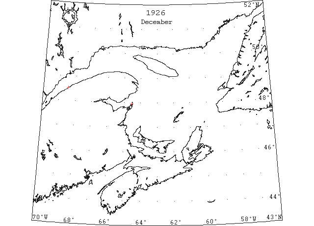
Dec 20 Pilotage officer, Father Point: Ice starts making. (CIS IC0708)
Dec 23 Last departure of the season from Quebec. (WBB)
Dec 25 J.A. Ward, Lightkeeper, Miscou Point, New Brunswick: Closing date. (CIS IC0756_2)
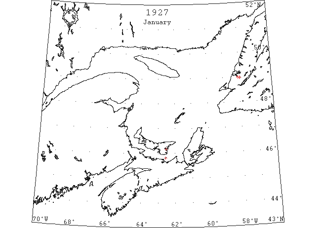
Jan 7 Georgetown – Likely the last arrival of the season, the schooner “Lady Hill” arrived from Little Bras D’ors with a load of coal. She was bound for Summerside but it was impossible to get up the Straits even to Charlottetown. (Pat 7 Jan p3 c4)
Jan 11 SS “Magnhild” sailed from Georgetown Tuesday (Jan. 11th) and Souris on Wednesday (Jan. 12th). Both harbours were free of ice. (Pat 13 Jan p8 c5)
Jan 12 So far there has been practically no skating this season to date. What little ice that made inside the bridge a while ago, melted during the recent mild weather. (TWS, p.3).
Jan 12 Last year this date there was from eight to ten inches of ice in Humber Arm, while today it is practically as free as in midsummer. (TWS, p.3).
Jan 12 River waters, backing from an ice jam, rose off Loneguiel, on the south shore of the St. Lawrence last night, and filled the cellars of more than two hundred homes on eight streets. The ice was piled forty feet above the Summer water level, and was on the railway along the water front. (TWS, p.4).
Jan 19 The dumping of garbage upon the ice of the harbor the past two winters provoked considerable criticism, but it was argued that there was no other means of disposing it. The absence of ice this season the question is being asked, how is the garbage being disposed of now. (TWS, p.3)
Jan 20? Georgetown – our harbour is still as open as the summer. The steamer on the Georgetown – Newport ferry is still running also the SS “Montague” on the Georgetown – Lower Montague route. (probably written previous week). (Pat 22 Jan p6 c7)
Jan 26 The frost and storm of Sunday made considerable slob ice in Humber Arm, which on Monday morning extended from Humbermouth to Curling. Since then it has extended out to Meadows Point, but it is not fit to pass over. (TWS, p.3)
Jan 26 Georgetown – the ice on the harbour now being fit for skating. The ferry boats running up until the 26th which is considered fairly late but a few years ago laying up on the 14th February and running again on the 27th March. (Pat 1 Feb p6 c2)
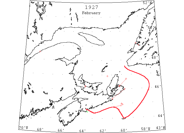
Feb Field ice put in its first appearance on February 10, when reported in a position between Cape Race and Sable Island. This ice was doubtless of St. Lawrence origin, it having blown offshore to the outer edge of the shelf. (IIP p53)
Feb 1 The car ferry left Tormentine …. about 3 miles off Borden in heavy ice. Five hours for 2 1/4 miles and 6 hours for the last 3/4 mile. (Pat 1 Feb p5 c2)
Feb 2 The first crossing over the ice on Humber Arm for the season was on Thursday, and on Saturday, teams were on the Arm. (TWS, p.2).
Feb 2 While crossing the Humber Arm on Monday morning, line reporter Wm. Brown fell through the ice as did also his dog and sleigh. (TWS, p.2)
Feb 4 Sydney, a strong northeast wind accompanied by snow which prevailed today is calculated by shipping interests to bring the ice field close to the mouth of Sydney harbor. The Reid Newfoundland steamer which arrived at North Sydney yesterday reported passing through a forty mile ice field. Today’s storm drove the field close to Cape Breton shores and closed the mouth of Sydney harbor. (HH 05/02/1927 p2#2)
Feb 9 Because of drift ice filling in Sydney Bight, the SS “Caribou” on Saturday evening sailed from North Sydney at 5 o’clock instead of waiting her usual time, which we understand is 9 p.m. She encountered ice crossing the Cabot Strait and was several hours late arriving at Port aux Basques. (TWS, p.2).
Feb 9 The ice on Humber Arm is now quite firm for traffic. (TWS, p.3).
Feb 9 Reports from out the Bay on Saturday stated that the drift ice was in to the headlands. (TWS, p.3)
Feb 9 Sydney, SS “Sidonia,” coal laden for the Old Country is en route across from Sydney, with the last cargo to leave this port this winter. The ship was convoyed through the ice field by the Government steamer “Montcalm,” which left North Sydney Saturday for Louisburg to convoy the tug “Cruizer” to the latter port. The “Montcalm’s” skipper said the ships had a difficult time navigating the ice floes from Saturday to Monday morning, the “Montcalm” bucked the heavy drift ice, making the slowest sort of progress. The field extends to sea from twenty to forty miles, and beyond the floe the ocean’s surface is frozen. Indicating sub-zero temperatures in the North Atlantic. (HH 10/02/1927 p9#1)
Feb 10 “Oxonian” thick field ice 45°52’N 57°20’W. (IIP p16#8)
Feb 10 SS “Oxonian” 45°52’N 57°20’W encountered thick field ice for about 3 miles, navigable with great caution. (HB #1955 Feb 23)
Feb 14 “Nerissa,” from St. John’s, Nfld., arrived yesterday morning; met considerable slob ice in coming out of St. John’s and past Cape Race and also had to force her way through miles and miles of field ice which extended well out to sea off the Cape Breton coast from Scaterie to the Strait of Canso. (HH 15/02/1927 p11#3,4)
Feb 15 Cape Race: Patches of field ice 44°56’N 60°00’W to 45°00’N 60°06’W. (IIP p16#16)
Feb 15 SS “Aurania” 44°35’N 60°23’W to 44°13’N 60°06’W passed along the southwestern limit of field ice and small pancake ice. (HB #1959 Mar 23)
Feb 19 Cape Race: Field ice 46°55’N 61°25’W. (IIP p16#19)
Feb 20 SS “Stockholm” 44°22’N 62°41’N: IIP should read fields of slob ice extending WSW – ENE thence to Halifax, also sighted several large growlers. (NYMR)
Feb 21 Heavy slob ice extending far out to sea off the Cape Breton coast, compelled the steamer “Farnorth, to go south of Sable Island on her voyage to Halifax form St. John’s, Nfld. (HH 22/02/1927 p11#1)
Feb 22 Halifax: The SS “Farnorth” while on passage from St. John’s to this port encountered miles of slob ice, close packed, along the coast and sighted a hundred large growlers, a majority of which constituted a menace to navigation. (HB #1956 Mar 2)
Feb 23 The harvesting of ice is now in progress. The ice crop this year promises to be a good one. In Humber Arm there is fifteen inches of good clear ice, with no snow. (TWS, p.5)
Feb 23 A menace to navigation in the form of three large ‘growlers’ four miles southeast of Chedabucto Head was reported in a message yesterday from the steamer “Montrolite”. A dense fog prevailed in the vicinity made the icebergs very dangerous to shipping. One of the pieces was 50 feet long and 10 feet high. (HH 23/02/1927 p16#7)
Feb 26 “Hellig Olav” field ice 44°52’N 60°10’W to 44°46’N 60°50’W. (IIP p16#34)
Feb 27 [SS “Hellig Olav” dated 26th in IIP continues with the following] …., steamed through rather heavy field ice scattered over a large area as far as could be seen, at times packed very closely, and many pieces were more than a foot in thickness; in Halifax Harbour, from Neverfail Shoal to Ives Point, steamed through closely packed ice which would have offered difficulty to low-powered steamers. (HB 1957 Mar 9)
Feb 28 SS “City of Peking” 45°55’N 59°50’W to 45°26’N 60°15’W heavy drift ice from 3 miles offshore as far as could be seen, but did not impede progress. March 1, 44°50’N 61°32’W to 44°30’N 62°W heavy drift ice stretching eastward as far as could be seen. It did not impede progress but some pieces were 50 feet square. (HB #1958 Mar 16)
Feb (end) Pilotage officer, Father Point: Very little ice left. (CIS 0708_2)
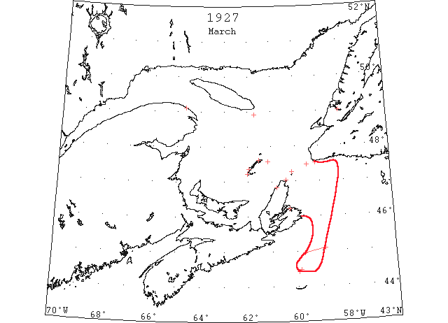
Mar 2 There is a little ice off shore Port aux Basques, but it is not interfering with the fishery and the ice is not as heavy as former years. (TWS, p.3).
Mar 2 Icebergs Menace Halifax- Unprecedented ice conditions off Halifax Harbor and the Nova Scotia coast heave been reported by steamers bound into that port. Capt. Murley of the liner “Farnorth” who arrived last night from St. John’s NF, said there were miles of “slob” ice packed close along the coast and near the harbor breakwater. In addition he counted 100 large icebergs off the coast, the majority of them constituting menaces to navigation. Outgoing steamers experience difficulty in dropping pilots owing to the ice and two have been carried away in the last days . (NYMR, p. 9, col. 3)
Mar 4 Fame Point, heavy close packed ice everywhere. Heath Point, Anticosti, heavy close packed ice distant. Magdalen Islands, Grindstone, clear and calm; Amherst, Grosse Isle, Etang du Nord and Pleasant Bay heavy close packed ice. Old Harry heavy open ice distant. St. Paul’s Island, heavy close packed ice. Money Point, heavy close packed ice stationary. Cape Ray, light close packed ice distant. (HH 05/03/1927 p25#2)
Mar 5 44°29’N 59°53’W to 44°25’N 59°58’W a large ice field extending as far as can be seen to N. (HB)
Mar 6 Str “Oscar” from lat 45°05’N lon 58°52’W to lat 44°57’N lon 59°42’W field ice. (NYMR 16 Mar p. 13, col.)
Mar 7 Fame Point, heavy close packed ice everywhere. Money Point, heavy close packed ice; south and southeast, open ice. Cape Ray, no ice in sight. (HH 08/03/1927 p14#5)
Mar 9 The SS “Caribou” is still plying to Louisburg instead of North Sydney from Port aux Basques, because of ice in Sydney Bight. On her trip across to Port aux Basques yesterday she brought 25 passengers. (TWS, p.2).
Mar 9 Some of our young people have manifested their sporting spirit by cleaning the snow for two rinks on the ice of the Humber Arm. (TWS, p.3).
Mar 9 Owing to the mild weather it was found necessary to close the rink on or two evenings the past week. (TWS p3)
Mar 9 Clear water all the way from Cape North to Cape Ray is the report of the Government ice breaker “Montcalm,” which had but little difficulty breaking through the ice and making port Sunday afternoon, followed by the SS “Caribou,” both boats making the trip from Louisburg without any trouble. It is hoped that navigation will not be hampered further by ice conditions and the “Caribou” will be able to make her regular. (HH 10/03/1927 p3#2)
Mar 14 The “Mikula” left Quebec last week and her progress has been comparatively rapid. The “Mikula” landed supplies and mails at north shore points, the first since navigation closed. She was due at Anticosti on Friday and from there was to proceed to the more distant places before returning to Quebec. The opening of navigation of course depends on the kind of weather which comes between now and the first of April. The fact that the “Mikula” was able to make such good progress going down the St. Lawrence river, gives encouragement that the channel will be cleared fairly early. The “Mikula” will have to break her way back to Quebec again and from the information gleaned on the return trip, the plans of the department as to the eventual united attack on the ice fields will be laid. A number of ocean going steamers were caught at Montreal and Quebec last fall with the early cold snap. (HH 14/03/1927 p9#2)
Mar 14 Fame Point, heavy close packed ice everywhere. Heath Point, heavy open ice distant. Magdalen Islands, Grindstone, clear north west wind; Amherst, Etang du Nord and Grosse Isle, heavy close packed ice. Old Harry heavy open ice distant. Pleasant Bay, no change. St. Paul’s Island, heavy close packed ice everywhere. Money Point. heavy close packed ice stationary. (HH 15/03/1927 p11#6)
Mar 18 Sydney, if the gulf ice has for the most part gone past, as present conditions would indicate a very early season for coal shipments from here and North Sydney up the St. Lawrence may reasonably be looked for. A day or two ago the keeper of the lighthouse at Low Point reported no drift ice in sight. This not surprising in view of the report made by the captains of the “Montcalm” and “Caribou” who stated that there was little ice off Sydney harbor and what was there was of a light open character and would soon disappear. They also expressed the opinion that the season of 1927 would be one of the earliest as far as ice conditions are concerned for some years. (HH 19/03/1927 p27#4)
Mar 30 The SS “Caribou” experienced a storm with a gale of wind from the north crossing the Cabot Strait on Sunday. She found Sydney Bight blocked with ice, and as a result she proceeded to Louisburg. (TWS, p.2).
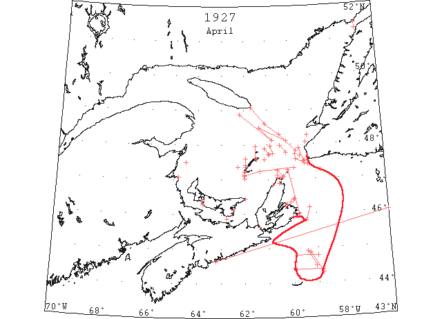
Apr A field projected out of the Gulf of St. Lawrence, its southern limits being reported 25 miles N of Sable Island on April 19. (IIP p58)
Apr 1 J.A. Ward, Lightkeeper, Miscou Point, New Brunswick: Opening date. (CIS IC0756_2)
Apr 2 St.Paul’s Is: Heavy close packed ice
Apr 2 Canadian Signal Service- Ice breaker CGS Montcalm reports today:5 AM left Louisburg, 8 AM position 45°49’N lon 59°26’W. From Louisburg to Point Nova to present position heavy close packed, broken ice making fair progress. SS “Beothik” reports ice 8 AM today- position 8 miles south of Magdalens in heavy jammed ice. (NYMR 6 Apr p. 13, col. 2).
Apr 2 Montcalm- from lat 45°49’N lon 59°26’W to lat 46°10’N lon 59°16’W, heavy close packed ice; Apr 3, from lat 47°46’Nlon 60°12’W to lat 47°58’N to lon 60°28’N heavy broken ice with occasional leads of open water; from lat 48°07’N lon 60°12’W to lat 48°30’N lon 61°21’W light slob ice with several large pieces of broken ice; northern edge of ice in lat 48°53’N lon 62°12’W lat 48°07’N lon 60°48’W to lat 48°30’N lon 61°21’W light slob ice with large leads of open water. (NYMR 13 Apr p. 13, col. 2)
Apr 4 “Beothic” Br sealer, about 15 miles E by S of Entry Island heavy close packed ice everywhere. (NYMR 13 Apr p. 13, col. 2)
Apr 4 Point Amour, heavy close packed ice. (HB #1962 Apr 13)
Apr 4 Ice floes caused delay to “Silvia”, reporting having passed through thick drift ice from St. Peter’s Bank to within a short distance of Halifax. ([HH?] 05/04/1927 p13#4)
Apr 5 Montcalm,- from lat 48°18’N lon 60°28’W to 48°36’N 61°06’W, broken ice with large pieces and occasional leads of open water, then to Heath Point, very little slob ice [cf HB Apr 5]. (NYMR 13 Apr p. 13, col. 2)
Apr 5 C.G.S. “Montcalm”: From 47°50’N 59°47’W to 48°18’N 60°28’W heavy close packed ice 4 miles in width with several pieces, thence to 48°36’N 61°06’W etc. [same as NYMR]. (HB #1962 Apr 13)
Apr 6 Canadian Signal Service: Magdalen Islands- Grosse Isle and Etang du Nord, heavy open ice. Old Harry and Amherst heavy open ice distant[cf – HB entry for Apr 6]. St. Paul Island- Heavy close packed ice. Point Amour- Light close packed ice distant. Belle Isle- Heavy close packed ice, 12 bergs. Longue Point- Channel open from Montreal to Bout de l’Ile. Cap St. Miche;- Several small spaces of open water in both channels. Bellmouth- Ice still holding in both channels. Sorel- Ice jam in islands still holding. Three Rivers- Some large pieces of ice from Lake St. Peter passing down. (NYMR 13 Apr p. 13, col. 2)
Apr 6 SS “Beothic” reports, 11 miles east by north of St. Paul Island, heavy loose ice. (NYMR 13 Apr p. 13, col. 2) [11 miles NE by N, (HB #1962 Apr 13)]
Apr 6 Amherst and Pleasant Bay, heavy close packed ice. (HB #1962 Apr 13)
Apr 6 Captain Stevenson, of the Newfoundland steamer “Caribou,” which arrived at Louisburg, reported the Cape Breton coast marooned behind a field of ice which extends to sea twelve miles. ‘We had a fine run across from Port aux Basques to within twelve miles of Low Point,’ said Captain Stevenson, ‘We arrived off Sydney Sunday morning at 3 o’clock and from that time until 4 p.m. we bucked the floes but could not get through.’ The “Caribou” ran into one sheet of ice between two and three miles long against which it was found impossible to make headway, the field which was loose at first, had become frozen solid, owing to the heavy frosts experienced the past few nights. The ship was held tightly for nine hours in the big sheet. Coming across the Cabot Strait we picked up the SS “Beothic,” of the Newfoundland sealing fleet. (HH 07/04/1927 p13#1)
Apr 7 Latest advices to the Marine and Fisheries department are to the effect that the steamer “Wolsom” would have a safe passage at the present time if she kept to a course in the lower river from the South Point of Anticosti to15 miles south, to 45 west, magnetic from Cape Ray. This would take her in a course through the northern part of the Cabot Strait in order to miss the ice which has gathered in the southern part of the strait. The “Montcalm” left Louisburg on April 2, meeting in some places heavy broken ice and in others light slob ice, and frequently throughout the trip large field of open water. (HH 08/04/1927 p11#1)
Apr 8 Drift Ice Damages Two Steamers at Mulgrave. Craft forced to Seek Safety in Open Water. Mulgrave, for the past week or ten days drift ice from the Gulf of St. Lawrence and the Northumberland Straits has been moving through the Strait of Canso directed by the prevailing wind and tide. (HH 09/04/1927 p3#3)
Apr 10 SS “Hellig Olav” from 44°47’N 59°W to 44°48’N 59°52’W encountered scattered rather heavy field ice. (HB #1964 Apr 27)
Apr 11 Sydney Mines, the ice barrier stretched across the entrance to the Sydney harbor shows visible indication of breaking up off Cranberry Head, although there is much ice from the Lowpoint Light to the Scotia shipping pier. The heavy fields are moving seaward and with favorable wind prevailing close observers of ice conditions predict that it is only a question of a few days when the harbor will be accessible to steamers and coal production will be resumed at the Scotia collieries. (HH 12/04/1927 p3#6)
Apr 12 Etang du Nord, 4 miles of heavy open ice N, 10 miles of heavy open ice W. Amherst, heavy close packed ice. Grosse Isle, 2 miles of heavy open ice inshore. Money Point, heavy close packed ice stationary. Point Amour, heavy close packed ice everywhere. (HB #1963 Apr 20)
Apr 12 When 60 miles southeast of Cape Canso Sunday in thick ice, the liner “Nerissa,” came upon a herd of seals sporting on the ice. At this time, the steamer could make only two miles an hour headway in the ice, so thick was it. Met strong Winds. Strong northwest winds prevailed about all the way from the Newfoundland port, and the “Nerissa” also had to contend with miles and miles of ice, in some place two feet thick. When the seals were sighted, the “Nerissa” was steaming four hours through exceptionally thick ice. (HH 12/04/1927 p11#3)
Apr 13 The Humber river is now open to down below the Railway Pier. (TWS, p.2)
Apr 13 The SS “Beothic” reports being jammed off Cape St. Lawrence. (TWS, p.2)
Apr 13? Magdalene Islands- Etang du Nord, Grosse Isle and Old Harry, heavy open ice; Pleasant Bay and Amherst, heavy close-packed ice St. Paul Island- Heavy open ice eastward and heavy, close packed ice southward. Point Amour- Heavy packed ice distant. Belle Isle- Heavy close packed ice, 12 bergs. (NYMR 13 Apr p. 13, col. 2)
Apr 14 Canadian Signal Service: Magdalene Islands: Grosse Isle, about 20 miles off heavy open ice inshore. Old Harry and Pleasant Bay, no ice in sight. Étang du Nord, 3 miles of heavy open ice on north side. Amherst, heavy close packed ice. Port Escuminac- Clear, heavy open ice inshore. Point Amour- Heavy close packed ice everywhere. Belle Isle- Heavy open ice everywhere, 15 bergs in sight. (NYMR 20 Apr p. 13, col.
Apr 16 First arrival of season at Quebec. (WBB)
Apr 17 SS “Colonian” 47°15’N 58°45’W light open patches of field ice; 47°27’N 59°26’W field ice of no danger to navigation. (HB #1965 May 4)
Apr 17 SS “Colonian” passed about 12 miles off Cape Ray Light; open ice to 47°35’N 59°48’W. (HB #1964 Apr 27)
Apr 17-18 C.G.S. “Mikula: Apr 17th, 47° 44N’ 59° 49’W strings of slob ice; Apr 18th, strings of soft broken and slob ice in 47°40’N 59° 37’W extending northeast and southwest as far as could be seen. This is the only ice sighted on course from Cape Ray to Bird Rock, thence to Cape Gaspe and Quebec. From Cape Ray to Cape Anguille, about 10 miles offshore, field of light ,broken and slob ice. (HB #1964 Apr 27)
Apr 18 W. Trembley, Master, SS “North Voyageur”: In 1927, I left St. John, N.B about the 18th of April with the SS “New Northland”, bound for ports of Quebec and Montreal. We passed 10 miles off Halifax lightship, and 45 miles off Cape Breton, proceeding on the same course for about 65 miles, and changed our course to pass about 10 miles off Cape Ray; then to about 15 miles off South Point, Anticosti, then to about 10 miles off Fame Point. During that distance, we did not see any ice, and during that time I had reports from the Patrol icebreaker that the ice was very heavy around St. Pauls Island, Cape North and Scatari Island. (CIS IC0717)
Apr 18 Cape Tormentine, light open ice distant. Cape Ray, light open ice everywhere. (HB #1964 Apr 27)
Apr 18 The liner “Silvia,” arrived yesterday morning at ten o’clock from St. John’s, Nfld. For three hours on Sunday when quite a distance off the Cape Breton coast, the “Silvia” ploughed her way through an ice field on which were counted over one hundred seals. (HH 19/04/1927 p11#3)
Apr 19 “Ascania” heavy field ice (31 bergs to date) 44°52’N 59°19’W to 44°18’N 58°49’W. (IIP p19#189)
Apr 19 Point Escuminac, heavy open ice inshore. Etang du Nord, strips of open ice on the N side, open ice to the W and SW. Grosse Isle, about 2 miles of open ice. Point Amour, heavy close packed ice everywhere. (HB #1964 Apr 27)
Apr 19 C.G.S. “Mikula”: From a position midway between St. Paul Island and Cape North, 8 to 10 miles off Cape Breton coast as far as Cape St. Lawrence, heavy close packed field ice; the northern edge extends to the NW as far as could be seen. This ice is moving slowly eastward and is likely to offer some obstruction to navigation when it reaches the steamer tracks in Cabot Straits, especially along the E coast of Cape Breton. Lying all night in heavy close packed ice in 47°48’N 60°40’W. (HB #1965 May 4)
Apr 20 “Sylvia” field ice with many growlers 44°25’N 60°00’W. (IIP p19#195)
Apr 20 The southern edge of the ice field is reported 25m N of Sable Is. and eastward to 58°50’W. [NYMR?]
Apr 20 SS “Caribou” heavy close packed ice off Flat Point. (HB #1965 May 4)
Apr 21 Canadian Signal Service, April 21: Point Amour- Heavy closely packed ice everywhere. Belle Isle- Heavy open ice, may bergs. Magdalene Islands- Amherst, heavy open ice 5 miles distant; Etang du Nord and Grosse Isle- No ice in sight. Pleasant Bay- Heavy open ice inshore. (NYMR 27 Apr p. 13, col. 5)
Apr 21 CGS Mikula, Apr 21- About 12 miles S of Cape St. George, field ice. (NYMR 27 Apr p. 13, col. 5)
Apr 22 SS “Alaunia” light slob ice off Cape Ray, extending SSW. (HB #1965 May 4)
Apr 22 Reports from Mulgrave yesterday said that the Gulf ice was still preventing steamers leaving the Strait of Canso. (HH 23/04/1927 p25#3)
Apr 23 “Canadian Rancher” slob ice (from St. Lawrence) 44°55’N 59°25’W to 44°29’N 59°05’W. (IIP p19#239)
Apr 23 Georgetown – every day you can see boats, dories, etc. on the move. Sheriff Murphy from his house on Panmure Island reports considerable ice off the Island for this time of year. (Pat 23 Apr p12 c7)
Apr 23 The telephone cable across the Straits of Wood Island is broken by the ice. (Pat 23 Apr p5 c3)
Apr 24 C.G.S. “Mikula”: The ice that was previously N and W of St. Paul Island and Cape St. Lawrence has moved eastward as far as the former and is likely to impede shipping, but can be worked through. 23rd., about 10 miles N 40° E (mag) from Cape Anguille, heavy close packed field; the ice is rotting rapidly. (HB #1965 May 4)
Apr 24 Georgetown – The ice left our harbour on April 24th, Sunday. In the past 20 years, the ice has left our harbour about 16 times on Sunday. The SS “Montague” is now running on the Georgetown – Lower Montague ferry. The SS “St. George” is running regularly on the Georgetown – Newport ferry route. Some fishermen ran their lobster lines on the 26th, others held back on account of the heavy ice. The schooner “Charlotte M.” cleared for North Sydney on April 26th. This is the first clearance of the season. The “Nellie J. Banks” cleared for St. Pierre Miquelon on April 25th. (Pat 2 May p7 c4)
Apr 25 Lightkeeper, East Point, PEI: Spring breakup. (CIS IC0993_2)
Apr 25 Money Point, light open ice. Etang du Nord, heavy open ice. Old Harry, open ice. Grosse Isle, heavy open ice. Amherst, heavy close packed ice. Pleasant Bay, heavy open ice inshore. (HB #1965 May 4)
Apr 26 St. Pauls Island, heavy open ice everywhere. Point Amour, heavy open ice inshore. (HB #1965 May 4)
Apr 26 The first steamer to enter the port of Summerside this season was the SS “Turret Cape” bound from Montreal for Pictou. The “Turret Cape” was forced by the great quantity of ice which has gathered in the Strait to put into this port on Tuesday (26th). The steamer left Montreal last Friday (22nd) and did not sight any ice until between Miscouche [Miscou] and North Point. During the past few days, large quantities have drifted into the Strait and yesterday a considerable amount found its way into Summerside Harbour which for a week previously had been clear. (Pat 29 Apr p8 c3)
Apr 27 The “Caribou” on yesterday’s run came through about fifty miles of ice and some of it rather heavy. (TWS, p.2)
Apr 27 The SS “Lovat” will make her first regular trip to the Magdalenes leaving Halifax on the 27th. The steamer will call at Souris on the 28th. (Pat 26 Apr p8 c4)
Apr 27 The steamer would have made her first trip to Victoria today but ice conditions made it absolutely impossible. (Pat 27 Apr p8 c3)
Apr 27-28 CGS “Mikula”: Vessels to Sydney will do well to follow course from Bird Rocks to St. Paul Island, west end, and along east coast of Cape Breton. Some heavy open ice in the vicinity of Cape North and St. Paul Island, but from this place to Sydney the ice is 8 to 15 miles off shore. Vessels passing through the Gulf on recommended tracks are having little difficulty. Stopped for the night in strings of heavy ice in lat 47°42’N lon 60°55’W. Apr 28: Patrolling this morning from lat 47°43’N lon 60°57’W through open strings of broken ice, with some very heavy pans to lat 47°54’N lon 61°07’W; no ice west or north, but eastern edge of this string (%:30 AM) was N 81°E (mag), 13 miles from Bird Rocks, then on eastern edge 141° (true) to lat 47°45’N lon 60°46’W escorting Tunet [Turret] Cape. Shipping progressing without difficulty. Ice becoming very scattered and broken by swells. Ice extends practically from St. Paul’s Island to Scatari, but well offshore, and vessels from south making good progress to Sydney, by keeping along western edge, this ice opening and breaking also. (NYMR 4 May p. 13, col. 1)
Apr 28 Canadian Signal Service: Summerside, PEI- Drifting ice in Strait. Money Point- Scattered ice north and southeast. Magdalene Islands- Étang du Nord, open ice distant. Amherst, close packed ice. St. Paul Island- Loose open ice everywhere. (NYMR 4 May p. 13, col. 1)
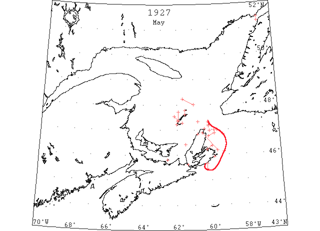
May 1-2 C.G.S. “Montcalm”: Believe broken and slob ice with heavy patches extends about 20 miles north and northwest from Magdalen Islands. Open ice extended northwestward from Etang du Nord yesterday as far as could be seen. Pleasant Bay full of open ice. The only ice which will be encountered on track from Fame Point to Bird Rock thence to a position off Cape Ray will be patches of loose field ice with clear intervals from. 48°14’N 61°40’W to 48°0’N 61°00’W. This ice can be cleared by keeping on its northern edge. May 2, it is believed that the prevailing northeast winds have driven the ice reported on Fame Point-Bird Rock Track to the southward. Last field of heavy open ice Southeast of St.Paul Island; ice also to the east and west. The strong northerly winds of last night, and today have probably driven Ice in on the eastern coast of Cape Breton. Large patches of field ice sighted in 45°27’N 60°16’W extending northward as far as the horizon. (HB #1966 May 11)
May 2 CGS “Montcalm”: It is believed that the prevailing northeast winds have driven the ice reported on Fame Point – Bird Rocks track to the south. Large field of heavy ice southwest of St. Paul’s Island, ice also to the east and west. The strong northeasterly winds of last night and today have probably driven ice in on the eastern coast of Cape Breton Island. (NYMR 11 May p. 13, col. 3)
May 2 Br .SS “Emperor” of Halifax, passed through Gut of Canso and Northumberland Strait, met some ice in the Gut and very little in the Strait. Recommend that route for southbound vessels. Some ice may be met at the outlet of the Gut of Canso, but it is easy to navigate. (HB #1966 May 11)
May 2 Magdalen Island still surrounded with ice. Pleasant Bay partly filled with open ice. (HH 03/05/1927 p12 #4)
May 2 On the 2nd May last year [1927] the “Canadian Snapper” was the first steamer to reach this port [Charlottetown]. (Pat 16 Apr 1928 p8 c3)
May 3 Amherst, close packed ice. Pleasant Bay, scattered pieces. Gross Isle, scattered ice distant. Etang du Nord, open ice. Point Amour, light open ice everywhere. (HB #1966 May 11)
May 5 Lightkeeper, East Point, PEI: Clear of ice. (CIS IC0993_3)
May 8-10 C.G.S. “Mikula”: Ice still streaming from between Magdalen Islands and Cape Breton Coast; the northern edge is in (approximately) 47°20N’ 60°47’W. Patrolled this morning from 46°45N’ 60°10’W along the southern edge to 46°52’N 59°50’W thence along the eastern edge to 47°00’N 59°51’W passing numerous isolated pans. May 9, the present wind is holding the remaining ice against the Cape Breton coast, and as this is still heavy it may obstruct track to Sydney. Ice 3 miles north (mag) of St.Paul Island, and strings of heavy broken ice and growlers were passed before meeting the main pack 8 miles south (true) from northeast end of St. Paul Island. This ice has blocked the entrance to Sydney Harbour. Heavy close packed ice in 46°59’N, 60°06’W. May 10, assisting four vessels through field of heavy close packed ice which extends from Cape North to about 5 miles east of Flint Island and is packed along the coast, blocking Sydney harbour. It is improbable that the track through the Gulf will be further troubled with ice this season. (HB #1967 May 18)
May 9 Magdalen Islands: ‘Excepting belt shore ice about half mile wide extending around from West Point to Grosse Isle, north side Magdalen Islands, clear ice; drift ice seen distant to southwest Pleasant Bay, and south side clear. No herring caught here yet. HH 10/05/1927 p13#5
May 10 St. Paul Island, heavy close packed ice S of here, extending to W. Etang du Nord, some broken ice inshore. Money point, heavy close packed ice. Point Amour, light close packed ice distant. (HB #1967 May 18)
May 11 Canadian Signal Service- Magdalene Islands, Amherst, close packed ice; Pleasant Bay, scattered small pieces; Grosse Isle, scattered ice distant; Etang du Nord, open ice. (NYMR 11 May p. 13, col. 3)
May 11-12 CGS “Mikula” reports ice loosing slightly, but situation practically the same off the east shore of Cape Breton. May 12 situation unchanged. Ice drifting south and east now off Louisburg also, but the harbor there is clear. (NYMR 18 May p. 13, col. 2)
May 12 Canadian Signal Service, St. Paul Island- Heavy close packed ice along the east side of the island, extending off about 2 miles to the Southwest Point, then west, south and southwest as far as can be seen. (NYMR 18 May p. 13, col. 2)
May 16-17 C.G.S. “Mikula”: No great improvement in conditions off Sydney; ice still very close packed from 10 miles off Flat Point to Sydney Bar. 17th, off Flat point the ice has opened considerably more than yesterday but is still light packed in places and there are large pans dangerous to ordinary ships in fog. The ice between East point, PEI, and the Cape Breton coast is opening but this area is not navigable yet. Shipping on other tracks passing through without difficulty. (HB #1968 May 25)
May 17 Magdalen Is., ice reported S and W of Entry Island. (HB #1968 May 25)
May 18 SS “Aurania” from 46°50’N 59°20’W to 47°N 59°40’W broken field ice and several large growlers; a solid ice field about 20 miles ENE of Scatari Island. (HB # 1970 Jun 8)
May 23 Coast Guard str “Montcalm” reports: The southwest wind today has driven the ice which has been on the east coast of cape Breton offshore and opened out considerably; vessels are entering Sydney without assistance; the ice in general is rotten, but there are many heavy patches which must be avoided; vessels in other routes progressing favorably. (NYMR 1 Jun p. 13, col. 2)
May 23 Point Amour, no ice in sight. (HB # 1969 Jun 1)
May 27 Point Amour, May 27- Light ice everywhere. Belle Isle- Packed ice on north side, strings of ice coastward, 38 bergs and numerous growlers. (NYMR 1 Jun p. 13, col. 2)
May 27 “Montcalm”- All routes now clear of ice except heavy open ice likely be in vicinity Pictou Island and between east Cape, PEI, and Cape Breton coast. (NYMR 1 Jun p. 13, col. 2)
May 31 Point Amour, light open ice everywhere; 5 bergs in sight. (HB # 1970 Jun 8)
Jun 1 Point Amour, light open ice everywhere. (HB 1971 Jun 15)
Jun 5 First Westbound steamer through the strait of Belle Isle. (WBB)
Jun 10 Point Amour, heavy open ice inshore, numerous bergs and growlers. (HB 1972 Jun 22)
Jun 13 “Swiftwater” first vessel of the season through the Strait of Belle Isle. (RG42 Vol.371)
Jun 20 Point Amour, heavy open ice everywhere, numerous bergs and growlers. (HB 1973 Jun 29)