1923 Season
Ice from east coast and Gulf met so that the island was surrounded by ice. (AH)
Nov 18 Last eastbound steamer through the Strait of Belle Isle. (WBB)
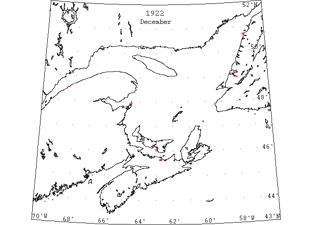
Dec 5 Summerside Bedeque ferry closed on December 5th. (Pat 22 Dec 1924 p5 c3)
Dec 10 Last departure of the season from Quebec. (WBB)
Dec 12 Rocky Point ferry cutting thru 4″ of ice on December 12th. (Pat 15 Dec 1922 p5 c5)
Dec 13 People crossed over the Humber from Summerside on ice on Saturday, the first time for the season. (TWS p2)
Dec 13 The schooner “Spencer Lake” which got caught in the ice at Penguin Arm, was liberated by the SS “Sagona” on Sunday. (TWS, p.2).
Dec 13 The SS “Stella Maris” left Halifax Saturday for Port au Port, via ports. Should ice conditions permit she will take a cargo of herring from Bay of Islands. (TWS, p.2).
Dec 13 The SS “Sagona” went to Middle Arm on Sunday to break up the ice and liberate some schooners that were frozen in, and fishing gear that had got caught in the ice. (TWS, p.2)
Dec 13 SS “Montcalm” returned yesterday from Bird Rock where they closed the lighthouse, etc. for the winter. (Pat, 14 Dec 1922 p5 c3)
Dec 14 CGS “Brant” left Georgetown on December 14th, fought her way through the ice towards Charlottetown but was caught in ice off Point Prim. Trapped until the wind shifted, she returned to Georgetown today. (Pat 18 Dec 1922 p1 c5)
Dec 15 Pilotage officer, Father Point: Ice starts making. (CIS IC0708)
Dec 15 Considerable rafted ice and a day by the CGS Montcalm in clearing the harbour. There are two schooners in port waiting to be towed out. (Pat 15 Dec 1922 p5 c5)
Dec 18 Steamer “Henry” unable to enter Pictou Harbour on trip to Magdalene Islands, will collect mail from Souris on 18th. (Pat 16 Dec 1922 p8 c4)
Dec 20 The icebreaker “Montcalm” made another trip yesterday as far as the harbour and back. Ice conditions were found to be the same. (Pat 21 Dec 1922 p2 c3)
Dec 24 J.A. Ward, Lightkeeper, Miscou Point, New Brunswick: Closing date. (CIS IC0756_2)
Dec 27 The SS “Edmond Donald” got caught in the ice of Port Saunders last week while on the way up to Hawkes Bay. (TWS, p.2).
Dec 27 The SS “Sagona” was unable to get around Point Riche on her last trip north, and was caught in the ice off Port Saunders several days. She got clear on Friday, however, and arrived at Port aux Basques the following day, having called Bonne Bay. (TWS, p.2)
Dec 27 The Norwegian steamer “Foina” arrived yesterday in Halifax. She left Charlottetown with the aid of the “Montcalm”. There were three feet of ice in the harbour when the steamer was ready to sail. (Pat 28 Dec 1922 p5 c3)
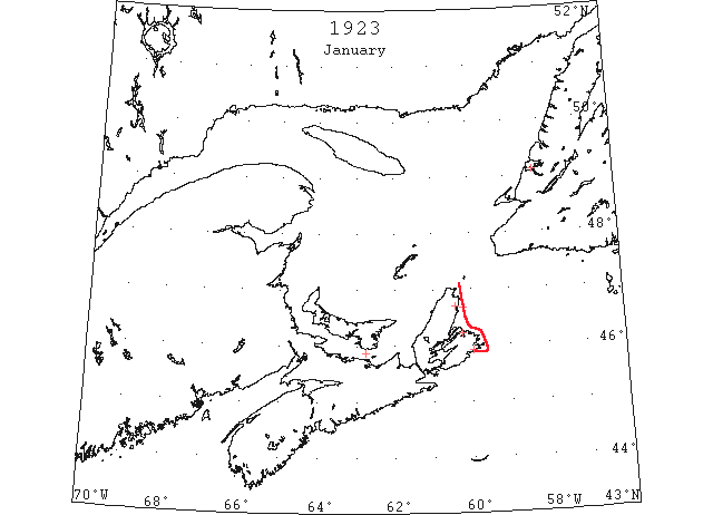
Jan 3 The south-west winds of Monday broke off the ice at Woods Island. (TWS, p.2)
Jan 17 Delayed by ice conditions, thirty hours, along the Eastern shore the steamer “Chedabucto,” arrived yesterday from Guysboro via intermediate ports. (HH 17/01/1923 p11#1 & 25/01/1923 p13#4)
Jan 23?? SS “Havur” 44°25’N 66°25’W: soft field ice. (HB 1745 Feb 14) [longitude highly suspect; may be 46°25’W since the sighting appears to be on the same day as a field ice sighting at 48°32’N 49°30’W]
Jan 26 North Sydney, the “Stanley,” which passed St. Pauls’ Island on Tuesday on her way back to this port after failing to reach Souris, enroute to the Magdalen Islands, was reported today to be off Ingonish in a very heavy ice field and making little progress. (HH 26/01/1923 p1#3)
Jan 26 A wireless message received here yesterday from master of the car ferry Prince Edward Island said extraordinary ice conditions were prevailing in Northumberland Strait. Another wireless states that the C G S “Stanley”’ is still of Ingonish in the ice pack. (HH 27/01/1923 p13#7)
Jan 27 Steamer “Stanley” position as eleven miles off Cape North, bearing north-north-west, where she is caught in heavy rafted ice. Captain Rhude said he was trying to free the ship, which has been caught in the ice field for nearly a week. (HH 29/01/1923 p13#8)
Jan 31 The schooner “Donald Silver” on the way from Halifax to Port aux Basques, put into Louisburg last Tuesday evening and was delayed there several days with slob ice. (TWS, p.2).
Jan 31 No ice has yet been reported by the “Kyle” crossing the Cabot Strait. There is considerable ice in Sydney Bight. (TWS, p.2).
Feb 1 Steamer “Stanley,” indicates that ice-breaker is still in difficulties but has hopes of an early escape to open water. Captain Rhude’s message reads as follows: Scatterie, bearing south by west, fifteen miles. Working through heavy ice, but see clear water west of us. (HH 01/02/1923 p14#3)
Feb 1 Cape Ray: light open ice everywhere, stationary. (HB 1745 Feb 14 CSS)
Feb 2 SS “Antonia” 43°30’N 64°25’W: large patches of close-packed pan ice from this position to Chebucto Head, to the limit of visibility. (HB 1745 Feb 14)
Feb 2 Cape Ray: open ice, moving north. (HB 1745 Feb 14 CSS)
Feb 3 The steamer “Kyle” is expected to dock in Louisburg this morning having been unable to make North Sydney on account of ice conditions. (HH 03/02/1923 p13#5)
Feb 3 Cape Ray: light open ice everywhere. Flat Point: light open ice everywhere, moving southeast. Paul Island: heavy close-packed ice, moving southeast. (HB 1745 Feb 14 CSS)
Feb 3 SS “Andania” 44°11’N 62°21’W: observed streaks of slob ice extending in a southeast and northwest direction; wind southeast, water and air temperatures 29° F. (HB 1746 Feb 21)
Feb 5 St. Paul’s Island: heavy close packed ice everywhere; Cape Ray and Flat Point: light open ice everywhere. (NYMR)
Feb 5 Cape Ray: light open ice everywhere. Flat Point: light open ice everywhere. St. Paul Island: heavy close-packed ice everywhere. (HB 1745 Feb 14 CSS)
Feb 6 St. Paul Island: heavy close-packed ice everywhere. Cape Ray: heavy close-packed ice everywhere. Flat Point: light open ice everywhere, moving southeastward. Point Amour: light close-packed ice everywhere, drifting southeastward. Belle Isle: light close-packed ice everywhere, drifting strong to the eastward. (HB 1746 Feb 21 CSS)
Feb 7 Parties have been engaged the past few days cutting ice in the Humber. We measured some taken out last week and it was 22 inches thick, but only about half of that was good ice. (TWS, p.2).
Feb 7 The SS “Kyle” had to go to Louisburg on her last trip, owing to Sydney Bight being blocked with ice. (TWS, p.2).
Feb 7 In an attempt to reach the Magdalen Islands with supplies, the Canadian Steamer “Stanley” got jammed off St. Paul’s Island. The ice in the Gulf is reported to be very heavy. (TWS, p.2).
Feb 7 The “Kyle” crossing Cabot Strait was reported on Monday as badly iced and making slow progress. (TWS, p2)
Feb 7 It was reported on Monday that two men of Long Point, Port au port, were missing. The report stated that two men, one of whom was named Chretien, were out in a boat fishing and that when they tried to get shore they were presented by slob ice, and that they went around Red Island. (TWS, p.2)
Feb 7 SS “Vennonia” 42°51’N 62°25’W: several large patches of field ice. (HB 1746 Feb 21)
Feb 7 SS “Bornholm” 43°08’N 65°45’W: passed through several small ice fields with ice from 4 to 6 inches thick. On the same day, off the south coast of Nova Scotia, steamed through heavy slob ice between Coffin Island and Brazil Rock. This ice extended from 6 to 7 miles offshore and was moving slowly to the westward. (HB 1746 Feb 21)
Feb 7 St. Paul Island: heavy close-packed ice everywhere. Flat Point: light open ice everywhere, moving southeastward. Belle Isle: heavy close-packed ice everywhere, drifting strong to the westward. (HB 1746 Feb 21 CSS)
Feb 8 St. Paul Island: heavy close-packed ice everywhere. Cape Ray: light close-packed ice everywhere. Flat Point: light open ice everywhere, moving southeastward. Point Amour: light close-packed ice everywhere. Belle Isle: heavy close-packed ice everywhere, drifting strong to the westward. (HB 1746 Feb 21 CSS)
Feb 9 SS “Knud” from Louisburg to St. John, NB damage to forepeak by ice. (NYMR)
Feb 9 SS “Rosalind”: The following information has been received from the Halifax agency of the Department of Marine and Fisheries, Canada: 44°00’N 59°00’W: heavy field ice as far as could be seen; soft slob ice for 60 miles west of Cape Race. (HB 1747 Feb 28)
Feb 10 St. Paul Island: heavy close-packed ice everywhere. Cape Ray: heavy close-packed ice, stationary. Flat Point: light open ice everywhere, moving southeastward. (HB 1746 Feb 21 CSS)
Feb 11 SS “Belvernon”: Cape Race to 45°07’N 56°06’W, heavy slob ice; thence to 43°33’N 59°13’W, heavy field ice; this field extends from the Cape Breton shore to 30 miles south of Sable Island. (HB 1747 Feb 28)
Feb 12 Capt. Joseph Hackett , who went to Port aux Basques on Feb 3 returned here on Friday’s train. He reports the Gulf full of very heavy ice. (TWS, p.2).
Feb 12 It is good travelling over the ice on the bay now. Last Friday Stephen Mollow walked here from Lark Harbor and covered the distance of twenty miles in 5 ½ hours. (TWS, p.2).
Feb 12 The SS “Sable I.”. met with heavy ice on her way in the Gulf last week, so she proceeded to Halifax. (TWS, p2)
Feb 13 A whale measuring 51 feet in length and six feet across the head, had been located off Port Hood harbor. The tail of the huge fish, which is embedded in drift ice, is broken. The mammal is of the Greenland type, and it is presumed that while swimming to close to the floes in the Arctic it’s tail became crushed and held between moving sheets of ice. Unable to get clear, the big fish perished. (HH 13/02/1923 p11#6)
Feb 13 St. Paul Island: heavy close-packed ice everywhere. Cape Ray: heavy close-packed ice everywhere. Flat Point: light close-packed ice everywhere. (HB 1746 Feb 21 CSS)
Feb 14 Is Digby in the Ice? St. John’ Nfld., immense quantities of ice between Nova Scotia and Newfoundland and extending to the Grand Banks were reported by the British steamer “Sachem” on her arrival here yesterday from Halifax. The ice was said to be in sufficient quantity to prevent west bound vessels from reaching this port. (HH 15/02/1923 p4,5)
Feb 15 “Rosalind” arrived here yesterday from St. John’s, Nfld. The ship forced her way through field ice practically all the way from the Newfoundland port as far as Sable Island, but from there to port met very little ice. (HH 16/02/1923 p13#3)
Feb 15 St. Paul Island: heavy close-packed ice everywhere. Cape Ray: heavy open ice distant. Flat Point: light close-packed ice everywhere, stationary. (HB 1747 Feb 28 CSS)
Feb 16 St. Paul’s Island and Money Point: Heavy close-packed ice everywhere. Flat Point: Light close-packed ice, stationary. Cape Ray: Heavy open ice, distant. Cheticamp: Considerable ice. (HH 17/02/1923 p16#5)
Feb 16 Flat Point: light close-packed ice everywhere, moving southeast. Cape Ray: heavy close-packed ice inshore. (HB 1747 Feb 28 CSS)
Feb 17 St. Paul Island: heavy close-packed ice everywhere, moving east. Cape Ray: heavy close-packed ice everywhere, stationary. Flat Point: light close-packed ice everywhere, stationary. Point Amour: light close-packed ice everywhere, moving east. (HB 1747 Feb 28 CSS)
Feb 17 SS “Schoharie”: from Sable Island to Halifax passed through almost continuous fields of slush ice stretching from horizon to horizon. The average size of the pieces of ice was 10 feet by 6 feet and 6 inches thick. The progress of the vessel was only slightly impeded. (HB 1748 Mar 7)
Feb 18 SS “Eastern Coast” 43°08’N 58°15’W: passed just southward of the eastern end of a large field of drift ice extending westward for 50 miles or more. [Report by radio.] (HB 1747 Feb 28)
Feb 18 SS “Eastern Coast” 43°08’N 58°15’W: passed streaks and large fields of drift ice, the southerly edge of which extended in a 250° direction for 50 miles or more. (HB 1748 Mar 7)
Feb 19 Mariners are warned that the ice conditions in Nantucket Sound and Buzzards Bay are becoming serious. The aids to navigation are liable to be displaced and light buoys to become extinguished. (HB 1747 Feb 28)
Feb 19 St. Paul Island: heavy close-packed ice everywhere, moving east. Cape Ray: heavy close-packed ice everywhere, stationary. Flat Point: light close-packed ice everywhere, moving southeast. Point Amour: light close-packed ice everywhere, moving west on 19th. Belle Isle: heavy close-packed ice everywhere; 1 berg. (HB 1747 Feb 28 CSS)
Feb 19 SS “Rhode Island” 42°53’N 63°20′ to 64°05’W: passed through patches of slob ice extending north and south as far as could be seen. (HB 1748 Mar 7)
Feb 19 SS “Hastings County”: The following ice reports have been received from the Department of Marine and Fisheries, Canada, Halifax agency: 44°09’N 63°30’W, passed through slob ice for the last 5 miles, and extending north and south as far as could be seen. (HB 1748 Mar 7)
Feb 19 SS “Bellingham” 47°07’N 58°47’W: large isolated patches of packed field ice. (HB 1751 Mar 28)
Feb 20 SS “Sagona” 6 days out from Port aux Basques is caught in an icefield 35m off Louisburg. (NYMR)
Feb 20 There is a heavy slob of ice along the south coast of Nova Scotia, extending about 10 miles off shore. From Brazil Rock, 43°21’N 65°26’W to 43°16’N 65°44’W, steamed through field ice from 4 to 6 inches thick. (NYMR 7 Mar)
Feb 20 Six days out from Port-aux-Basques, the steamer “Sagona” is caught in a field of heavy Arctic ice about 35 miles off Louisburg and is drifting further south with every tide. When the ship first got caught the floes were open, but now these have frozen into a huge field with no open water, as far as the eye can see. Even the “Stanley” is unable to penetrate a field of this description, and there is nothing for the “Sagona” to do but lie quiet and husband her coal for a final effort, when the first heavy gale breaks up the field. It may be several days before the ice breaks and lets her through to Louisburg. (HH 21/02/1923 p2#6)
Feb 20 SS “Sagona”: 6 days out of Port-aux-Basques, was caught in an ice field 35 miles off Louisburg. The Government ice breaker was unable to reach her. (HB 1748 Mar 7)
Feb 20 SS “Bornholm”: there is heavy slob ice along the south coast of Nova Scotia extending about 10 miles offshore. From Brazil Rock (43°21’N 65°26’W) to 43°16’N 65°44’W, steamed through field ice from 4 to 6 inches thick. (HB 1748 Mar 7)
Feb 20 St. Paul Island: heavy close-packed ice everywhere, moving southeast. Cape Ray: heavy close-packed ice everywhere. Flat Point: light close-packed ice everywhere, moving southeast. Point Amour: light close-packed ice everywhere, moving west. (HB 1748 Mar 7 CSS)
Feb 21 Cape Ray: heavy close packed ice everywhere; Cape Race: slob ice, heavy, open. (NYMR)
Feb 21 SS “Fullerton” 43°00’N 59° to 61°W: field ice with patches as far as could be seen. (HB 1748 Mar 7)
Feb 21 SS “New Mexico”: The following ice reports have been received from the Department of Marine and Fisheries, Canada, Halifax agency: 42°45’N, and from 63°30′ to 64°W, [field ice] as far southward as could be seen. (HB 1748 Mar 7)
Feb 21 St. Paul Island: heavy close-packed ice everywhere, moving southeast. Cape Ray: heavy close-packed ice everywhere. Flat Point: light close-packed ice everywhere. Point Amour: light close-packed ice everywhere. Belle Isle: heavy close-packed ice everywhere, one berg. (HB 1748 Mar 7 CSS)
Feb 22 Obliged to go fifty miles south of Sable Island to clear the ice fields, the “Silva” arrived here yesterday morning at six o’clock from St. John’s Nfld., and sailed for New York. In spite of the fact that the “Silva” was practically obliged to plough her way through ice for forty hours after passing Cape Race, the ship made the voyage from St. John’s in fifty hours, the weather being quite moderate for a February trip. Going from Halifax to St. John’s on her last trip, the “Silva” encountered ice shortly after leaving port, which necessitated a southern passage, and the course was set to make about 40 miles south of Sable Island. Ten hours before arriving at St. John’s, the “Silva” passed through heavy sheet ice about twelve to fifteen inches thick. (HH 23/02/1923 p11#6)
Feb 22 SS “Fullerton” 43°00’N 63° to 64°W: field ice as far as could be seen. (HB 1748 Mar 7)
Feb 22 SS “Lord Antrim” 42°44’N 58°34’W: passed patches of field ice. (HB 1748 Mar 7)
Feb 22 SS “Dunaff Head”: The following ice reports have been received from the Department of Marine and Fisheries, Canada, Halifax agency: 43°10’N 63°30’W, pan ice. (HB 1748 Mar 7)
Feb 22 St. Paul Island: heavy close-packed ice everywhere, moving east. Cape Ray: heavy close-packed ice everywhere. Flat Point: light close-packed ice everywhere. (HB 1748 Mar 7 CSS)
Feb 22 “Cheektowaga” (tug): The following information concerning the prevailing ice conditions on the American coast has been taken from the New York Maritime Register: lost two blades of her propeller at the entrance to Penobscot Bay, Maine, where ice 2 feet in thickness was encountered. (HB 1748 Mar 7)
Feb 23 Reports of weather conditions in Bay of Islands, Nfld, give no hope that the Gloucester and Nova Scotia schooners loaded with herring can make a clearing from the ice before several more weeks have elapsed. The ice in the bay is reported as being of unusual thickness. The vessels which are waiting for the break to come were caught while trying to make a get-away just as the cold snap hit in early December. (HH 23/02/1923 p11#1)
Feb 23 SS “Lord Antrim” 43°00’N 63°00’W: patches of field ice. (HB 1748 Mar 7)
Feb 23 SS “Bradford City”: from 60 to 80 miles westward[eastward?] of Halifax, N.S., extensive fields of pan ice. (HB 1748 Mar 7)
Feb 23 SS “Pittsburg” 43°24’N 58°40’W: sighted field ice extending northward as far as could be seen; skirted the edge of the field until clear of the ice in 43°45’N 59°12’W. (HB 1748 Mar 7)
Feb 23 St. Paul Island: heavy close-packed ice, moving southeast. Cape Ray: heavy open ice everywhere, stationary. Flat Point: light close-packed ice everywhere. Point Amour: light close-packed ice everywhere, moving eastward. (HB 1748 Mar 7 CSS)
Feb 23 SS “Digby” 42°50’N 58°35’W: ran into heavy field ice and cleared it in 42°45’N 58°45’W; 44°25’N 60°53’W, slob ice to within 6 miles of the approach to Halifax. (HB 1749 Mar 14)
Feb 23 SS “Horda”: from 44°01’N 57°05’W to 43°00’N 60°00’W, heavy packed field ice extending as far north and south as could be seen. (HB 1749 Mar 14)
Feb 24 SS “Pro Patria” from Halifax to St. Pierre caught in the ice 40m south of St. Pierre and seeking assistance. (NYMR)
Feb 24 SS “Pittsburg” 43°45’N 62°13’W: encountered field ice, which extended to Halifax. (HB 1748 Mar 7)
Feb 24 St. Paul Island: heavy close-packed ice, moving south. (HB 1748 Mar 7 CSS)
Feb 24 Flat Point: light close-packed ice everywhere, stationary. (HB 1748 Mar 7 CSS)
Feb 24 SS “Pro Patria”: The following information concerning the prevailing ice conditions on the American coast has been taken from the New York Maritime Register: [vessel] is fast in the ice 40 miles south of St. Pierre, Miquelon. (HB 1748 Mar 7)
Feb 25 The following information has been received from the Department of Marine and Fisheries, Canada, Halifax agency: 43°20’N 58°20’W to 44°20’N 56°00’W, heavy field ice; 43°29’N 57°31’W to 43°12’N 58°14’W, passed extensive and heavy field ice. At the latter position ice was in sight in all directions except eastward. (HB 1749 Mar 14)
Feb 26 SS “Rosalind” for St. John’s from Halifax making slow progress in heavy ice 85m SW of Cape Race. (arrived Feb 27) (NYMR)
Feb 26 The French steamer “Pro Patria” is caught in the ice forty miles south of St. Pierre and thirty east [west?], and is asking for assistance, according to advises to her agents here on Saturday. Some of her propellers are broken. (HH 26/02/1923 p11#2)
Feb 26 St. Paul Island: heavy close-packed ice, moving southeast. Cape Ray: heavy close-packed ice everywhere. Flat Point: light close-packed ice everywhere, stationary. Belle Isle: heavy close-packed ice everywhere, one berg. (HB 1748 Mar 7 CSS)
Feb 26 SS “Algiers”: The following information concerning the prevailing ice conditions on the American coast has been taken from the New York Maritime Register: Philadelphia for Houston, was obliged to return to her port of departure, having sustained damage to her port bow through contact with ice. [Seems to indicate significant ice in the approaches to Philadelphia harbour.] (HB 1748 Mar 7)
Feb 26 SS “Bradavon”: The following information has been received from the Department of Marine and Fisheries, Canada, Halifax agency: 42°30’N 59°00’W to 42°26’N 58°30’W, heavy packed ice as far as could be seen north and south. (HB 1749 Mar 14)
Feb 27 Small icebergs at, 42°36’N 62°05’W; heavy ice in area, 43°20’N 59°20’W, 44°20’N 56°00’W, 43°29’N 57°31’W, and 43°21’N 58°14’W. (NYMR 7 Mar)
Feb 27 Heath Point: Heavy open ice, distant. Magdalen Islands, St. Paul’s Island, Money Point, Flat Point and Cheticamp: Heavy close packed ice everywhere. (HH 28/02/1923 p16#1)
Feb 27 St. Paul Island: heavy close-packed ice everywhere, moving east. Flat Point: light close-packed ice everywhere. Point Amour: heavy close-packed ice everywhere, moving east. (HB 1749 Mar 14 CSS)
Feb 28 At 42°20’N 65°50’W a field of slob ice 10 miles long by 5 miles wide was passed. (NYMR 7 Mar) Feb 28 SS “Sagona” still in heavy pack 75m SE of Scatari Island. (NYMR)
Feb 28 Several harbor seals are being caught through the ice at Lark Harbor and Batteau [Bateau?] Cove with hook and bait. (TWS, p.2).
Feb 28 After being over two weeks on the trip from St. John’s, the SS “Portia” was still jammed off St. Lawrence yesterday. (TWS, p.2).
Feb 28 Two oxen teams came from Trout River over the ice to Middle Arm some days ago. This is quite an unusual trip for teams, but it proved quite feasible as the ice was one solid field and quite safe enough for heavy teams. (TWS, p.2).
Feb 28 Ice conditions at Port aux Basques are such as have not been before in the history of cross-country railway. One can walk or drive to Isle aux Morts, something not known for the past twenty years or more, and at Channel and at Port aux Basques teams are hauling heavy loads over the ice. (TWS, p.2).
Feb 28 The “Sable I.” and “Rosalind” were in the ice of Cape Race on Monday. (TWS, p.2).
Feb 28 The SS “Sagona” left Louisburg last Thursday night and has since been jammed in the ice 40 miles S. E. of Scatterie. (TWS, p.2)
Feb 28 The Canadian Government ice-breaking steamer “Stanley” will leave Halifax this morning to proceed to the rescue of the French steamer “Pro Patria,” which since Saturday last has been caught fast in a heavy, close-packed field of drift ice, about 40 miles south of St. Pierre. News dispatches from Newfoundland ports, the Director of Signals, Quebec, and from St. Pierre, Miquelon, state that the ice conditions obtaining in the Gulf of St. Lawrence and along the whole Newfoundland coast are the worst in fifty years, this being the first time in that period, that the harbors at St. Pierre have been blocked by the floes. The “Pro Patria,” on the St. Pierre-Halifax route, left here for the French port about a week ago yesterday afternoon. Saturday last, advices were received to the effect that the steamer was caught in ice 40 miles from St. Pierre and partially disabled, three of her propeller blades having been broken. (HH 28/02/1923 p1#6)
Feb 28 SS “Sagaporack” 42°20’N 65°50’W: passed through a field of slob ice 10 miles long by 5 miles wide. (HB 1748 Mar 7 and HB 1749 Mar 14)
Feb 28 St. Paul Island: heavy close-packed ice, moving southeast. Flat Point: light close-packed ice everywhere, stationary. Cape Ray: heavy close-packed ice everywhere. (HB 1749 Mar 14 CSS)
Mar 1 41°59’N 59°48’W. Field ice. (IIP, P64)
Mar 1 A wireless message from Louisburg to St. John’s, reports the “Sagona” jammed in heavy close packed ice, through which the ship can make no progress. The field is frozen solid, and stretches away over the ocean as far as the eye can reach. The captain states that never, even in the Arctic regions, has he encountered such conditions. The Reid service between Cape Breton and the Colony completely out of service. The “Kyle” is still held at Port aux Basques and the “Portia,” which was sent from St. John’s to assist her, had to put into Trepassey Bay to escape being crushed in the ice fields. With all coastal vessels held fast by ice packs in harbors on the southern seaboard of Newfoundland, reports received by wireless indicate that ice conditions were the worst in fifty years. Further requests for help from isolated towns where food supplies were running short have been received by the colony government. (HH 01/03/1923 p11#3)
Mar 1 The following information was received from Cape Race by radio via Bar Harbor, Mar. 1, 1923: heavy ice in area bounded as follows: 43°20’N 59°20’W; 44°20’N 56°00’W; 43°29’N 57°31’W; and 43°12’N 58°14’W. (HB 1748 Mar 7)
Mar 1 SS “Blifdendijk”: 42°31’N 59°57’W to 42°25’N 60°06’W passed through patches of easily navigated slob ice. (HB 1749 Mar 14)
Mar 1 St. Paul Island: heavy close-packed ice, moving southeast. Cape Ray: heavy close-packed ice everywhere, stationary. Flat Point: light close-packed ice everywhere. (HB 1749 Mar 14 CSS)
Mar 2 Canadian Government steamer “Stanley” from Louisburg for “Pro Patria” got stuck in the ice 50m ESE of Louisburg; Mar 4, “Stanley” picked up “Pro Patria” and being towed to St. Pierre, 3 blades of propeller and rudder gone. (NYMR)
Mar 2 Canadian Government ice breaker “Stanley”, which sailed form Louisburg yesterday in an attempt to reach the steamer “Pro Patria” disabled in the ice 70m from St. Pierre, wirelessed today that she herself had been caught in an ice field 50m ESE of Louisburg. (NYMR 7 Mar)
Mar 2 Proceeding through heavy field ice, which, however, offered some leads, the government icebreaker “Stanley” reported herself at five o’clock last evening to be twenty-seven miles south east by east of Louisburg and on her way to aid the French steamer “Pro Patria.” The “Pro Patria,” with three blades stripped off her propeller, had been helpless in the ice about seventy miles off St. Pierre for the past week. Her ten passengers and her crew are faced with a shortage of fresh water. The steamer has been out from Halifax since February 20. (HH 02/03/1923 p12#3)
Mar 2 The Canadian Government ice breaker “Stanley”: while attempting to reach the French steamer “Pro Patria” disabled in the ice 70 miles from St. Pierre, has herself been caught in an ice field 50 miles ESE. of Louisburg. New York Herald (HB 1749 Mar 14)
Mar 2 St. Paul Island: heavy close-packed ice everywhere, moving south. Cape Ray: heavy close-packed ice everywhere. Flat Point: light close-packed ice everywhere, stationary. (HB 1749 Mar 14 CSS)
Mar 2 SS “Besseggen”: 43°07’N 58°15’W to 43°10’N 59°20’W, field ice extending as far north as could be seen. (HB 1750 Mar 21)
Mar 2 SS “West Kebar” 42°31’N 62°24’W: passed through field ice for 1½ hours. (HB 1754 Apr 18)
Mar 3 “West Kebar” field ice. 41°59’N 59°48’W. (IIP p64)
Mar 3 St. Paul Island: heavy close-packed ice everywhere. Cape Ray: heavy close-packed ice everywhere, stationary. Flat Point: light close-packed ice everywhere. (HB 1749 Mar 14 CSS)
Mar 3 SS “West Kebar” 41°58’N 59°52’W: encountered field ice from 6 a.m. until 10.30 a.m.; clear weather; smooth sea and light easterly winds. (HB 1754 Apr 18)
Mar 4 Having drifted with the ice for a distance of 75 miles, the French steamer “Pro Patria,” which for almost eight days was held prisoner by the unprecedented ice conditions in the North Atlantic, was relieved by the Canadian government icebreaker “Stanley,” at nine o’clock yesterday morning. She was then 115 miles south of St. Pierre and the latest report from Captain Rhude states that he has taken the distressed steamer in tow and is proceeding to that port. The release of the “Pro Patria” was not expected so soon, as daily reports are that the prevailing ice conditions are the worst in half a century, and up to yesterday morning, Captain Rhude reported that he was steaming in a blinding snow storm through a heavy packed ice. The icebreaker left here Wednesday forenoon, and proceeded to Louisburg for bunker, leaving there Thursday afternoon. From then on, it was a continuous battle of steel and will against ice and wind. Little progress was made Thursday, and Friday morning she was 140 miles from the beleaguered vessel. Terrific ice conditions were reported and that night the “Stanley” was in heavy running ice with no open water in sight. All this time a heavy northeast gale had been raging, making the position of the “Pro Patria” desperate, as running ice is the great danger of imprisoned vessels. Driven by wind and tide on meeting an immovable object, the ice “rafts” or piles up sometimes overwhelming the vessel or crushing her hull by its immense weight. Saturday’s advices reported the icebreaker as smashing her way through the floes, but making little progress. Evidently a “lead” of open water was encountered throughout the night and proceeding through the snow storm, doubtless guided by wireless from the “Pro Patria” the “Stanley” finally came up with her yesterday. (HH 05/03/1923 p1#3)
Mar 4 SS “Ariano” 43°31’N 61°17’W: steamed through heavy field and pack ice to 42°26’N 60°38’W. (HB 1752 Apr 4)
Mar 4 SS “Latvia”: 43°43’N 60°50’W to 42°48’N 60°10’W observed a field of closely packed ice extending northward as far as could be seen. (HB 1754 Apr 18)
Mar 5 “Venusia” field ice extending W 60 miles. 41°58’N 59°30’W. [cf. Mar 5 HB 1752] (IIP p64)
Mar 5 A great field of slob ice, estimated to be ten miles long and several miles in width is reported well off the south of Bay of Fundy. (HH 05/03/1923 p9#1)
Mar 5 The Red Cross liner “Rosalind” arrived here yesterday from St. John’, having been somewhat delayed by ice. Captain James reports leaving the Newfoundland port on Thursday at noon and the following day the ship was overtaken by a blizzard form the Northeast and this together with ice conditions necessarily caused low progress. Practically all the way from St. John’s the “Rosalind” found very little open water. It was sheet ice off the Newfoundland coast, heavy drift ice south east of Sable Island – and close-packed at that – slob ice from Sable Island to Halifax. (HH 05/03/1923 p12#3)
Mar 5 On account of ice conditions, the schooner “Douglas B Conrad,” which left Liverpool, (NS), twenty days ago for St. Pierre, was obliged to give up the attempt to reach the French port and put back here yesterday afternoon and anchoring in the stream. (HH 06/03/1923 p12#4)
Mar 5 St. Paul Island: heavy close-packed ice everywhere, moving southwest. Flat Point: light close-packed ice everywhere. (HB 1749 Mar 14 CSS)
Mar 5 SS “Bolivian”: The following information has been received by radio: 43°43’N 60°50’W to 42°48’N 60°10’W, large field of ice. (HB 1750 Mar 21)
Mar 5 SS “Venusia”: 41°58’N 59°30’W to 41°59’N 59°49’W, passed through slob ice. (HB 1752 Apr 4)
Mar 6 SS “Sinasta” SW limit of icefields 42°23’N 60°10’W extending to 48°30’W and as far north as can be seen. (NYMR)
Mar 6 “Sinasta” reports SW limit of icefields 42°23’N 60°10’W extending easterly to 48°30′(W?) as far north as can be seen. (NYMR)
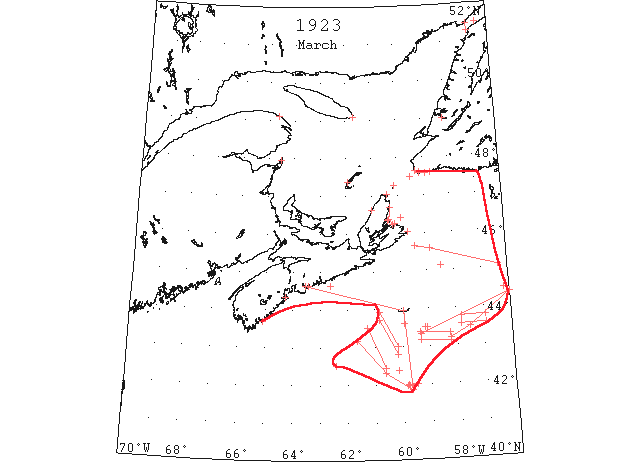
Mar 6 After a grim battle of 35 hours, during which she smashed her way through 115 miles of the heaviest field of drift ice reported in fifty years, the Canadian government icebreaker “Stanley” with the disabled French steamer “Pro Patria” in tow, arrived safely at St. Pierre Monday evening steaming slowly in the teeth of a northeast gale. This, the latest triumph of the “Stanley” was accomplished in the face of seemingly insurmountable difficulties, and stands to the distinct credit of her able and experienced commander, her officers and crew. When the report reached Halifax last Thursday night that the rescue ship was hung up in heavy running ice 27 miles east southeast of Louisburg and 140 miles from the “Pro Patria,” belief in her ability to force a passage through the barrier dwindled to a certain extent in some quarters. (HH 07/03/1923 p1)
Mar 6 Cape Ray: heavy close-packed ice everywhere, moving south. Flat Point: light close-packed ice everywhere. (HB 1749 Mar 14 CSS)
Mar 7 Ice conditions continue to interfere with codfish operations at Channel and vicinity. (TWS, p.2).
Mar 7 The SS “Portia” after having been jammed with ice at St. Lawrence for several days, got clear on Saturday. (TWS, p.2).
Mar 7 Should present ice conditions prevail, it is not likely that any schooners will prosecute the seal fishery in the Gulf this season. (TWS, p.2).
Mar 7 It is reported that in Straits of Belle Isle the ice is solid from shore to shore, and that people are able to cross over on it by dog team. (TWS, p.2).
Mar 7 Very fine ice was taken out of Rapid Pond last week by the railway people for their icehouse at Humbermouth. Some of it measured very near three feet in depth. (TWS, p.2)
Mar 7 The following information has been received from Cape Race by radio via Bar Harbor: 43°11’N 61°39’W to 42°19’N 60°38’W, thence to 41°52’N 59°40’W, heavy packed ice. (HB 1750 Mar 21)
Mar 7 St. Paul Island: heavy close-packed ice everywhere, moving southeast. Cape Ray: heavy close-packed ice distant. Flat Point: light close-packed ice, moving southeast. Point Amour: heavy close-packed ice distant. (HB 1750 Mar 21 CSS)
Mar 8 The schooner seen fast in the ice off Sable Island last is now believed to be the “Bohemia. (HH 08/03/1923 p16#1)
Mar 8 St. Paul Island: heavy close-packed ice everywhere, moving southward. Flat Point: heavy close-packed ice distant, moving east. Point Amour: heavy close-packed ice distant. (HB 1750 Mar 21 CSS)
Mar 8 Fame Point: heavy open ice everywhere. (HB 1754 Apr 18 CSS)
Mar 9 According to marine reports there is not a patch of water showing from Belle Isle Strait to the Cape Breton coast. The Gulf of St. Lawrence is choked with an Arctic pack the like of which has not been seen in the past century. At times this winter it has been possible to cross from Low Point to Cape Ray, on the west coast of Newfoundland, so densely was the ice packed over Cabot Strait. The Magdalens are surrounded by an impenetrable field, so deep and wide that Captain Rhude advised the government that the “Stanley” had better not attempt to reach the islands until in the spring. A rather unusual feature of this season’s ice is that it stretches around the coast of Nova Scotia as far south as Sable Island. This is the longest drift that has been known for many years. (HH 09/03/1923 p9#1)
Mar 9 It is quite likely that none of the Newfoundland sealing fleet will be sent to prosecute the fishery in the Gulf this spring, as the ice floes are to heavy for even these stout ships to navigate. (HH 09/03/1923 p9#1)
Mar 9 The “Stanley” arrived at Louisburg last evening from St. Pierre, after a fight since Wednesday morning with great close-packed ice fields. The ice is now about forty miles off this coast. While the southwesterly gales of Wednesday blew the ice to sea around the eastern Nova Scotia coast, it would appear that it is heavier and more close packed then ever outside. (HH 10/03/1923 p18#2)
Mar 9 A radio message from Cape Race via Bar Harbor advises schooners attempting to make the Nova Scotia coast that the ice floe appears impossible to penetrate. (HB 1750 Mar 21)
Mar 9 St. Paul Island: heavy close-packed ice moving southeast. Cape Ray: heavy open ice everywhere. Flat Point: heavy close-packed ice everywhere moving southeast. (HB 1750 Mar 21 CSS)
Mar 10 The fresh fishing for the month of February, says a Lockeport report, has been a complete failure on account of the great quantity of drift ice along the whole coast. The vessels have been out several days but had to return as they were unable to find clear water enough to set their trawls. Lockeport fishermen have never experienced a condition like this before. The whole ocean had been as smooth as a harbor for the entire month, and there has not been sea or wind enough to carry the ice off shore. Therefore it just drifts up and down the coast with the tides. This ice will stay until a heavy storm breaks it up or some mild weather melts it. The lobster season is on, but on account of the ice and extreme cold weather the fishermen are unable to get their traps out and the water being so cold the lobsters are not moving. (HH 10/03/1923 p15#1)
Mar 10 St. Paul Island: heavy close-packed ice moving southeast. Cape Ray: heavy close-packed ice distant, moving south. Flat Point: heavy close-packed ice inshore. Point Amour: heavy close-packed ice distant. (HB 1750 Mar 21 CSS)
Mar 10 A gale of wind swept across Grand [Bay?] River ice on Mar 10. Very little damage was done, however, but the gale was severely felt. (TWS 14 Mar p.2).
Mar 12 There are thirteen three-masted schooners frozen in at Lunenburg, N. S. (NYMR, p.10, col.5)
Mar 12 St. Paul Island: heavy close-packed ice moving southeast. Cape Ray: heavy close-packed ice distant, moving southeast. Flat Point: heavy close-packed ice distant, moving southeast. HB 1750 Mar 21 CSS)
Mar 12 The following radiogram has been received from the [US] Coast Guard Cutter “Seneca”: field ice reported south of Sable Island to 41°52’N 59°40’W; limits doubtful. (HB 1750 Mar 21 CSS)
Mar 13 light slob ice off Halifax. (NYMR)
Mar 13 Schooner “Novelty” met drift ice 43°55’N 54°W. In ice for the next 8 days or so finally making Lunenberg on 5 April. (HDR)
Mar 13 St. Paul Island: heavy close-packed ice everywhere, moving west. Flat Point: heavy close-packed ice everywhere, moving west. Point Amour: heavy close-packed ice distant. Belle Isle: heavy close-packed ice everywhere; six bergs. (HB 1750 Mar 21 CSS)
Mar 13 SS “Andania”: light slob ice off Halifax Harbour extending northeast and southwest. (HB 1752 Apr 14 CSS)
Mar 14 The SS “Portia” reached Channel, and left there again on the return trip to St. John’s on Sunday, after a passage of nearly a month along the coast, being delayed by ice conditions. (TWS, p.2).
Mar 14 At Channel fishermen have not been able to get on the fishing grounds for over a month owing to the whole gulf being filled with ice. Similar conditions prevail at Burnt Islands and Rose Blanche. (TWS, p.2)
Mar 14 St. Paul Island: heavy close-packed ice everywhere. Cape Ray: heavy close-packed ice everywhere, stationary. Flat Point: heavy close-packed ice everywhere. Point Amour: heavy close-packed ice everywhere. Belle Isle: heavy close-packed ice everywhere, 7 bergs. (HB 1751 Mar 28 CSS)
Mar 15 St.Paul’s Is., heavy close packed ice everywhere, moving SE; Cape Ray – heavy close packed ice everywhere moving south; Cape Race, heavy open ice everywhere, moving SE; Point Amour, heavy open ice everywhere, moving SE; Belle Isle, heavy close packed ice everywhere, 8 bergs; Eastern Harbour, NS, ice still solid. (NYMR 7 Mar)
Mar 15 “Cottage City” 43°30’N 59°09’W large ice field and several growlers. (NYMR 7 Mar) (IIP p64)
Mar 15 SS “Quaker City” 43°30’N 59°05’W: large field of ice and several growlers. [Report by radio.] (HB 1751 Mar 28)
Mar 15 St. Paul Island: heavy close-packed ice everywhere, moving southeast. Cape Ray: heavy close-packed ice, moving south. Belle Isle: heavy close-packed ice everywhere, 8 bergs. Point Amour: heavy open ice everywhere, moving southeast. (HB 1751 Mar 28 CSS)
Mar 15 Eastern Harbour, N.S.: ice still solid. (HB 1751 Mar 28 CSS)
Mar 16 St. Paul Island: heavy close-packed ice everywhere, moving southeast. Cape Ray: heavy close-packed ice, moving southeast. Point Amour: heavy close-packed ice everywhere. (HB 1751 Mar 28 CSS)
Mar 17 After being two days in heavy sheet ice, the steamer “Sable I” arrived at St. Pierre yesterday morning from Halifax. (HH 17/03/1923 p13#7)
Mar 19 St. Paul Island: heavy close-packed ice everywhere, moving south. Cape Ray: heavy close-packed ice everywhere, stationary. Flat Point: heavy close-packed ice distant, moving southeast. (HB 1751 Mar 28 CSS)
Mar 20 St. Paul Island: heavy close-packed ice everywhere, moving southeast. Flat Point: heavy close-packed ice distant, moving southeast. Cape Ray: light close-packed ice everywhere, stationary. Point Amour: heavy close-packed ice everywhere, moving southeast. Belle Isle: heavy open ice distant, nine bergs. (HB 1752 Apr 4 CSS)
Mar 21 The SS “Glencoe” has been ice-bound in Placentia Bay since January. (TWS, p.2)
Mar 21 Gulf of St. Lawrence, generally, heavy ice packs prevail. Around the Magdalene and St. Paul Islands there is heavy close packed ice everywhere. At Cape Ray and Cape Race the heavy closely packed ice remains stationary. Point Amour is closed in by the ice packs, while at Belle Isle heavy open ice is seen in the distance. This same condition is at Heath Point and Flat Point. Point Tupper and Louisburg are entirely free from ice, while there is no change at Cheticamp. (HH 22/03/1923 p18#1)
Mar 21 Flat Point: heavy close-packed ice distant, moving southeast. Point Amour: heavy close-packed ice everywhere, moving east. Belle Isle: heavy close-packed ice everywhere. (HB 1752 Apr 4 CSS)
Mar 22 43°34’N 56°55’W a large icefield sighted extending 40m in a westerly direction and as far northward as could be seen. (NYMR)
Mar 22 SS “Belvernon” at Boston was damaged by ice between St.John’s via Halifax. (NYMR)
Mar 22 As showing the extreme cold weather of the present winter, residents of Breton Cove report that an ice bridge has been formed on the Atlantic Ocean, between Cape Dolphin and Bird Islands. For the first time in 41 years it has been possible to drive a team from Cape Dolphin [sic = Dauphin] to Bird Islands on locally formed ice. In years gone by people have occasionally crossed from the cape to the island on drift ice, but this winter the horse racing enthusiasts in that section have held races on the solid ice formed between the cape and the islands. Residents of Ingonish have driven along the coast on the ice bridge to Sydney Mines, something which has rarely happened. (HH 23/03/1923 p1#5)
Mar 22 SS “Alderamin” 43°34’N 56°55’W: a large ice field extending 40 miles in a westerly direction and as far northward as could be seen. (HB 1751 Mar 28)
Mar 22 St. Paul Island: heavy close-packed ice everywhere, moving southeast. Flat Point: heavy close-packed ice distant, moving southeast. Cape Ray: light close-packed ice everywhere, stationary. (HB 1752 Apr 4 CSS)
Mar 23 The Red Cross liner “Rosalind” arrived here Saturday morning from Newfoundland being obliged to go 20 miles south of Sable Island to escape the ice field. (HH 26/03/1923 p9#6)
Mar 23 The steamer “Sable I,” arrived here on Saturday morning from St. John’s, Nfld., after being delayed en route by ice conditions and which forced the steamer to go well south of Sable Island. (HH 26/03/1923 p9#7)
Mar 24 Flat Point: heavy close-packed ice distant, moving south. Cape Ray: heavy close-packed ice everywhere, moving east. Point Amour: heavy close-packed ice everywhere, moving west. (HB 1752 Apr 4 CSS)
Mar 26 St. Paul Island: heavy close-packed ice everywhere, moving east. Flat Point: heavy close-packed ice distant, moving southeast. Cape Ray: heavy close-packed ice everywhere, stationary. Point Amour: heavy close-packed ice everywhere, moving southeast. Belle Isle: heavy close-packed ice distant, seven bergs. (HB 1752 Apr 4 CSS)
Mar 27 Fishing schooner “William A Morse” at Halifax after collision with iceberg off Sable Island. (NYMR)
Mar 27 Cape Ray and Belle Isle: heavy close packed ice, distant. (NYMR)
Mar 27 Arrived at Halifax, N.S., the auxiliary fishing schooner “William A. Morse”: 10 days out of New York, with a hole in her starboard side at the waterline and propeller shaft bent, through collision with an iceberg off Sable Island. New York Herald (HB 1752 Apr 4)
Mar 27 St. Paul Island: heavy close-packed ice everywhere, moving southeast. Flat Point: heavy close-packed ice distant, moving south. Cape Ray: heavy close-packed ice distant. Point Amour: heavy close-packed ice distant. Belle Isle: heavy close-packed ice distant, seven bergs. (HB 1752 Apr 4 CSS)
Mar 28 W. J. Boland had a crew cutting and putting in ice last week for his ice cream parlor. (TWS, p.2)
Mar 28 The Newfoundland schooner “Bohemia,” which left Boston for Halifax some time ago and was later reported in the ice off the Cape Breton coast, was abandoned in 45°00’N 55°13’E according to reports from St. John’s. (HH 28/03/1923 p11#4)
Mar 28 Sydney, although the drift ice is moving out from the Gulf into the Atlantic little by little each day, the sea is still covered with heavy floes all the way from Cape Breton to Newfoundland as ice reports received this morning indicate. Flat Point reports heavy close packed ice in the distance, moving to the south; St. Paul’s Island reports heavy close packed ice everywhere moving to the east; Money Point heavy close packed ice north and open water with scattered ice packs to the south; Cape Ray, heavy close packed ice everywhere, stationary. It is the Gulf ice that now stops steamers from making the trip north. The Strait of Belle Isle is clear of ice and the Labrador coast as well. The following cable was received from St. John’s relative to ice conditions along the Labrador coast: No heavy ice visible from Battle Harbor in any direction. Seal Island reports no ice north as far as can be seen. Prevailing winds north to northeast. (HH 29/03/1923 p13#2,3)
Mar 28 There is still close packed ice around the Magdalen Islands, St. Paul’s Island, Money Point, Point Amour, and Belle Isle. Heavy close packed ice is seen in the distance at Cape Ray, Heath Point and Flat Point. (HH 9/03/1923 p16#1)
Mar 28 St. Paul Island: heavy close-packed ice everywhere, moving north. Flat Point: heavy close-packed ice distant. Point Amour: heavy close-packed ice distant. Belle Isle: heavy close-packed ice distant; five bergs. (HB 1753 Apr 11 CSS)
Mar 29 St. Paul Island: heavy close-packed ice distant, moving southeast. Cape Ray: heavy close-packed ice everywhere, moving southeast. Flat Point: heavy close-packed ice inshore. (HB 1753 Apr 11 CSS)
Mar 30 Inspectors of lights for the Department of Marine and Fisheries, are back from Yarmouth. They report that the ice along the Nova Scotian coast has almost all gone and that not much damage was done by it. (HH 31/03/1923 p13#6)
Mar 30 Back to port yesterday came the steamer “Bernard M.” after failing to land at St. Pierre. She left Halifax a week ago yesterday. All went well until last Wednesday when she got caught in the ice 120 miles south of St. Pierre and she was obliged to circle a dozen times steaming at least forty miles in circling to get into open water. The position of the “Bernard M.,” when she was obliged to put about to return to Halifax was latitude 44°27’N 56°12’W or 170 miles east of Sable Island. (HH 31/03/1923 p16#3)
Mar 31 St. Paul Island: heavy close-packed ice everywhere, moving northwest. (HB 1753 Apr 11 CSS)
Apr (early) Gulf and entrance of gulf heavy close packed ice. Flat Point and Point Tupper no ice in sight. Ships proceeding Louisburg from Halifax advised to stay 4 or 5 miles offshore. (IIP p19)
Apr Previous experience has shown that the St. Lawrence ice begins to break up from the middle of April to the first part of May. Many steamers sail from European ports, arriving on the edge of the pack ice at the entrance to Cabot Strait and forcing their way in as the ice weakens. This year was no exception. (IIP p28)
Apr Southern limit of field ice from Cape Breton to 44°30’N 53°W and over St. Pierre Bank. Heavy ice coming out of Gulf. (IIP p30)
Apr 1 J.A. Ward, Lightkeeper, Miscou Point, New Brunswick: Opening date. (CIS IC0756_2)
Apr 2 St. Paul Island: heavy close-packed ice everywhere, moving southeast. Cape Ray: heavy close-packed ice everywhere. (HB 1753 Apr 11 CSS)
Apr 3 SS “Tritonia”: 45°11’N 56°00’W to 45°03’N 55°52’W, very close packed ice (HB 1761 Jun 6)
Apr 4 The “Glencoe” and the “Argyle” are still icebound in Placentia Bay. (TWS, p.2).
Apr 4 The “Portia” was at Hermitage, icebound on Monday. (TWS, p.2)
Apr 4 St. Paul Island: heavy close-packed ice everywhere. (HB 1754 Apr 18 CSS)
Apr 5 St. Paul Island: heavy close-packed ice everywhere, moving southwest. Flat Point: heavy close-packed ice distant, moving southeast. (HB 1754 Apr 18 CSS)
Apr 5-6 US CGC “Modoc”: wireless message from “Wireless Officer Halifax” re two vessels (SS “Procyon” and SS “Callisto”) reported by “Modoc” as bound for Louisbourg, Nova Scotia, “Ships proceeding Louisberg[sic] from Halifax steer four or five miles off coast, Gulf and entrance of Gulf heavy close-packed ice. Flat Point and Point Tupper [both in N.S.], no ice in sight” … “No reply was received from the “Procyon” after several calls. April 15th the latter [SS “Procyon”], bound east, returning from Louisberg[sic] reported to the Patrol that through being unable to receive the [April 5-6] advice from the Patrol for approaching the coast [of N.S.], she ran into field ice, damaging her propeller.” (from the cruise report of Captain B.M. Chiswell of the U.S. Coast Guard Cutter “Modoc”, dated April 19, 1923, entitled ‘Ice Patrol Report April 3 to 17, 1923. First cruise of MODOC’ addressed to the Commandant. U.S. National Archives and Records Administration, Record Group 37, Hydrographic Office, General Correspondence 1907-1924, Box 150, Ice Patrol Ships Reports, File 260268/2995psr, Item 1, pp. 7-8)
Apr 6 Steamer “Sable I” arrived here yesterday from St. John’s Nfld. Captain Murley reports the usual ice trouble after leaving St. John’s and between Cape Race and Sable Island his ship got jammed twice in the ice, thick fog also making navigation of the ship extremely hazardous with ice conditions as they were. (HH 07/04/1923 p20 #4,5)
Apr 7 Fame Point: heavy open ice everywhere. Heath Point: heavy close-packed ice everywhere. Cape Ray: heavy close-packed ice everywhere. Point Amour: heavy close-packed ice everywhere, moving northwest. Belle Isle: heavy close-packed ice distant; five bergs. (HB 1754 Apr 18 CSS)
Apr 8 Fame Point: heavy open ice everywhere. (HB 1754 Apr 18 CSS)
Apr 9 Grosse Isle, M.I.: heavy open ice distant, moving east. (HB 1754 Apr 18 CSS)
Apr 11 It is thought the St. Lawrence will be freed of ice in less than two weeks. (TWS, p.3)
Apr 11 Fame Point: light open ice distant. Grosse Isle, M.I.: heavy close-packed ice. St. Paul Island: heavy close-packed ice everywhere, moving southeast. Flat Point: heavy close-packed ice, moving southeast. Point Amour: heavy close-packed ice everywhere, moving east. Belle Isle: ice moving east; six bergs. (HB 1755 Apr 25 CSS)
Apr 12 Grindstone Island, M.I.: close-packed ice off Étang du Nord. St. Paul Island: heavy close-packed ice, moving northeast. Flat Point: heavy close-packed ice, moving southeast. (HB 1755 Apr 25 CSS)
Apr 13 SS “Digby” 46°32’N 53°07’W: encountered patches of heavy ice, and continued steaming through heavy field ice interspersed with clear water to 44°29’N 55°42’W, where open water was reached. (HB 1756 May 2)
Apr 13 St. Paul Island: heavy close-packed ice, moving east. Flat Point: heavy close-packed ice distant. (HB 1755 Apr 25 CSS)
Apr 14 Arriving here last evening was the Norwegian steamer “Marshall,” which is temporarily on the route between Boston, Halifax and St. John’s, Nfld., and replacing the “Belvernon” which is now at New London, Conn., undergoing repairs on account of being damaged in the ice floes between Sable Island and Newfoundland. (HH 14/04/1923 p17#7)
Apr 14 St. Paul Island: heavy close-packed ice. Flat Point: heavy close-packed ice distant. (HB 1755 Apr 25 CSS)
Apr 16 Grosse Isle, M.I.: heavy open ice. St. Paul Island: heavy close-packed ice. Flat Point: heavy close-packed ice distant. (HB 1755 Apr 25 CSS)
Apr 17 Will the ports of Montreal and Quebec be open by the time the first passenger liners are due to arrive? This is the question that is in the minds of Halifax shipping men today when the first ships of the season are due to leave trans-Atlantic port for the St. Lawrence. Unless there is a rapid change in river conditions it is possible that they will suffer more or less serious delay which would result in the liners being diverted to Halifax as has been done before. Men who have watched the St. Lawrence each spring for years predict that the ice will not go for another fourteen or fifteen days and for several days after this there will be large masses of ice floating down towards the sea. According to prophets the river can hardly be clear in time to permit the uninterrupted passage of the ships now leaving the other side of the Atlantic. (HH 17/04/1923 p11#3)
Apr 17 Back to port the second time after failing to reach St. Pierre on account of the ice fields, the steamer “Bernard M” arrived here yesterday after being out since last Sunday morning endeavoring to make the French port. She was no further than 120 miles south of St. Pierre and 160 miles east of Sable Island. (HH 20/04/1923 p9#4)
Apr 17 Grosse Isle, M.I.: heavy open ice. St. Paul Island: heavy close-packed ice. Flat Point: heavy close-packed ice distant. (HB 1755 Apr 25 CSS)
Apr 18 Grosse Isle, M.I.: heavy open ice. St. Paul Island: heavy close-packed ice everywhere. Flat Point: heavy close-packed ice; Sydney Harbour clear. (HB 1756 May 2 CSS)
Apr 18 US CGC “Tampa”: “The [International Ice] Patrol had previously secured information of field ice north of Sable Island that would cause this passage to be regarded as dangerous to navigation. The [S.S.] “Ariano” was therefore informed of the situation … and [she] stated that she had changed [her course] to pass 30 miles south of Sable Island. (from cruise report of Captain William J. Wheeler of the U.S. Coast Guard Cutter “Tampa”, dated May 2, 1923, entitled ‘Report of Second Ice Patrol cruise, April 17-May 2, 1923’, addressed to the Commandant, U.S. National Archives and Records Administration, Record Group 37, Hydrographic Office, General Correspondence, 1907-1924, Box 150, Ice Patrol Ships Reports, File 261511/2995psr, Item 2, p. 9)
Apr 19 Magdalen Islands, St. Paul’s, Souris, heavy close packed ice; Louisburg, Point Tupper, no ice insight. Chatham, Bathurst, Dalhousie, Gaspe, ice still solid; Cape St. Lawrence, ice opening up; Flat Point, closely packed ice in distance; Montreal to Three Rivers, ice still holding; Quebec to Heath Point, no ice; Magdalen Islands, open and closely packed ice; St. Paul’s, Money Point, Flat Point, Port Hood, Cheticamp, Cape St. Lawrence, heavy closely packed ; Cape Tormentine, no ice. (HH 20/04/1923 p12#1)
Apr 19 St. Paul Island: heavy close-packed ice, moving north. Cape Ray: heavy close-packed ice, stationary. Flat Point: heavy close-packed ice distant, moving south. (HB 1756 May 2 CSS)
Apr 20 Grosse Isle, M.I.: heavy close-packed ice. St. Paul Island: heavy close-packed ice everywhere, moving southeast. Cape Ray: heavy close-packed ice everywhere. Flat Point: heavy close-packed ice 4 miles distant, moving south and closing in on the coast. Point Amour: heavy close-packed ice everywhere. Belle Isle: heavy open ice, distant. (HB 1756 May 2 CSS)
Apr 21 The stations of the Canadian Signal Service reports ice as follows: Point Escuminac, heavy close packed ice distant; Grosse Isle, MI, heavy open ice; St. Paul’s Island, heavy, close packed ice; Flat Point, heavy close packed ice distant 4 miles, moving southeast; Montreal to Port St. Francis, ice still holding, scattered ice passing down between Pointe Citrouille and Quebec. (NYMR, p.13, col.3)
Apr 21 Flat Point, heavy closely packed ice four miles off shore moving to south and closing in on the coast; St. Paul’s Island, heavy closely packed ice everywhere, moving to south east; Money Point, ice heavy and closely packed moving to south east; Point Tupper, strait clear of ice. (HH 21/04/1923 p12#2)
Apr 21 “Stanley” bucking 2 ½ feet of harbour ice in Sydney. Ice in Sydney Harbour is of exceptional thickness for this time of year. Last year the harbour opened on April 12th, in 1921 on April 1st and in 1920, three days earlier. The latest date on which the harbour opened to shipping was April 29th in 1904, 1906 and 1907. (Pat 21 Apr p6 c4)
Apr 21 Point Escuminac: heavy close-packed ice, distant. Grosse Isle, M.I.: heavy open ice. St. Paul Island: heavy close-packed ice. Flat Point: heavy close-packed ice distant 4 miles, moving southeast. Point Amour: heavy close-packed ice everywhere. (HB 1756 May 2 CSS)
Apr 23 Large ice field 47°58’N 46°56’W and 47°30’N 46°55’W with numerous bergs to westward. Ice field extends from Cape Breton coast to 45°N 54°W thence northward over St. Pierre Banks. (NYMR)
Apr 23 Point Escuminac: heavy open ice everywhere. Grindstone Island, M.I. (West Point): heavy open ice. St. Paul Island: heavy close-packed ice. Flat Point: heavy close-packed ice, distant 3 miles, moving south. Point Amour: heavy close-packed ice everywhere, moving east. (HB 1756 May 2 CSS)
Apr 23 SS “Rosalind” 45°25’N 53°50’W: dense fog temp 32[°F] steering N 22° E true have met no ice this course. Louisburg[sic] can be made in open water by coming to 44°50’N 54°00’W then working WNW and NW along southern edge of ice[. I] think this ice covers well over St. Pierre Bank to 55°W from Cape Breton Coast” (from cruise report of Captain William J. Wheeler of the U.S. Coast Guard Cutter “Tampa”, dated May 2, 1923, entitled ‘Report of Second Ice Patrol cruise, April 17-May 2, 1923’, addressed to the Commandant, U.S. National Archives and Records Administration, Record Group 37, Hydrographic Office, General Correspondence, 1907-1924, Box 150, Ice Patrol Ships Reports, File 261511/2995psr, Item 2, p. 10 of 14)
Apr 23 Two years ago [1922] the ice in the Humber went out on 24th April. Last year [1923] it was 13th May before the Humber became clear of ice. This year [1924] navigation on the Humber open on 20th April. (TWS 1924 p.2)
Apr 24 On the route from Brier Island (44°15’N 66°23’W) to within 20 miles of Patridge Island, in the approach to Saint John, NB, passed a large field of slob ice. The coast from Point Lepreau to Musquash is clear of ice. Ice still holding between Montreal and St. Francis. (NYMR, p.13, col.3)
Apr 24 Ice conditions permitting, the steamer “Stanley” will call at Souris on her first trip to the Magdalene Islands. (Pat 24 Apr p8 c4)
Apr 24 SS “Empress of Britain”: on the route from Brier Island (44°15’N 66°23’W) to within 20 miles of Partridge Island, in the approach to St. John, N.B., passed a large field of slob ice. The coast from Point Lepreau to Musquash is clear of ice. (HB 1756 May 2)
Apr 24 Grindstone: Grosse Isle, heavy close-packed ice moving west; West Point, heavy close-packed ice offshore; Étang du Nord, heavy open ice. St. Paul Island: heavy close-packed ice everywhere, moving west. Cape Ray: heavy close-packed ice everywhere. Point Amour: heavy close-packed ice everywhere. (HB 1757 May 9 CSS)
Apr 24 SS “Cairnvalonia”[sic = “Cairnvalona”] 46°10’N 55°50’W: 1530 GMT, have been passing through open field ice since reaching 46°N 54°20’W steering west dead slow during day, stopping at night. (from cruise report of Captain William J. Wheeler of the U.S. Coast Guard Cutter “Tampa”, dated May 2, 1923, entitled ‘Report of Second Ice Patrol cruise, April 17-May 2, 1923’, addressed to the Commandant, U.S. National Archives and Records Administration, Record Group 37, Hydrographic Office, General Correspondence, 1907-1924, Box 150, Ice Patrol Ships Reports, File 261511/2995psr, Item 2, p. 4)
Apr 24-28 SS “Horda”: 46°15’N 54°40’W to 47°30’N 59°10’W, passed through close-packed ice field extending in all directions as far as could be seen. (HB 1759 May 23)
Apr 25 Traveling on the ice over Humber Arm has become very bad. There is considerable water on the ice, and with a few days hot sunny weather the ice would be quite unsafe. (TWS, p.2).
Apr 25 In the outer part of Bay St. George the ice last week was firm and on Wednesday a team was able to cross from Port au Port to Sandy Point. (TWS, p.2).
Apr 25 After battling with heavy drift ice in the Gulf for about two weeks, the SS “Kyle” reached Port aux Basques from St. John’s on Saturday evening. She left again at 2 a.m. on Sunday for North Sydney. (TWS, p.2).
Apr 25 The ice at outer part of Bay of Islands went off the early part of last week. It is gone from Weetald. A dory came from Trout River to Crabbes Brook the latter part of last week. (TWS, p.3)
Apr 25 Money Point, heavy and closely packed stationary; St. Paul’s Island, heavy closely packed ice moving west; Point Tupper, strait clear. (HH 25/04/1923 p16#1)
Apr 25 International Ice Patrol Service. The following radiogram [was] received from the U.S. Coast Guard cutter on patrol [US CGC “Tampa”]: Ice field extends from Cape Breton to 45°N 54°W, thence northward over St. Pierre Bank. (HB 1756 May 2)
Apr 25 Point Escuminac: heavy close-packed ice inshore. Grindstone: West Point, heavy close-packed ice; Étang du Nord, heavy close-packed ice to the northward and heavy open ice to the westward. St. Paul Island: heavy close-packed ice. (HB 1757 May 9 CSS)
Apr 25 SS “Cairnvalona 46°20’N 56°50’W: heavy field ice. (HB 1758 May 16)
Apr 25 SS “Cairnvalona” 46°30’N 57°14’W: steamed dead slow through heavy open field ice extending in all directions, becoming heavier to the westward. (HB 1757 May 9)
Apr 26 Flat Point, heavy closely packed ice stationary. Point Tupper, strait clear; St. Paul’s Island, heavy closely packed ice, moving to north; Cape Ray, cloudy, heavy closely packed ice in distance, moving to north west. (HH 27/04/1923 p14#1)
Apr 26 Yesterday two dogs became marooned on a cake of ice in the river. (Pat 27 Apr p8 c4)
Apr 26 St. Paul Island: heavy close-packed ice, moving north. Cape Ray: heavy close-packed ice everywhere. Flat Point: heavy close-packed ice everywhere, stationary. Point Amour: heavy close-packed ice everywhere, moving west. (HB 1757 May 9 CSS)
Apr 26 SS “Cairnvalona” 46°46’N 58°10’W: surrounded by heavy open field ice, getting heavier as Cabot Strait is approached. (HB 1757 May 9)
Apr 26 SS “Cairnvalona 47°15’N 58°58’W: close-packed ice, progress slow. (HB 1758 May 16)
Apr 26 SS “Horda 47°14’N 58°55’W: at 8.40 p.m., encountered closely packed ice. (HB 1757 May 9)
Apr 26 SS “Cymric Queen” 45°25’N 60°00’W: heavy pack ice. (HB 1760 May 30)
Apr 26 French trawler “La Province”: “At 5:00 p.m. received via St. Pierre: “American Patrol “Tampa”. Three American citizens aboard French Trawler “La Province” from St. Pierre now stuck in outer edge of ice propeller damaged coal exhausted. Been aboard eight days no accomodations[sic] and sick. Will you take us off for any near port. Our position 59-12 W. Paris meridian [~2°22’E], Latitude 43-23 N.”” (from cruise report of Captain William J. Wheeler of the U.S. Coast Guard Cutter “Tampa”, dated May 2, 1923, entitled ‘Report of Second Ice Patrol cruise, April 17-May 2, 1923’, addressed to the Commandant, U.S. National Archives and Records Administration, Record Group 37, Hydrographic Office, General Correspondence, 1907-1924, Box 150, Ice Patrol Ships Reports, File 261511/2995psr, Item 2, p. 5)
Apr 27 SS “Cymric Queen” hemmed in by ice 45°35’N 60°35’W. (NYMR)
Apr 27 “Cairnvalonia” surrounded by field ice 47°21’N 59°22’W. (IIP p66)
Apr 27 Schooner “Marion Phyllis” has gone to Port Hastings from Isaac’s Harbor. On account of ice conditions in the Strait of Canso, she has not yet reached the Cape Breton port. (HH 27/04/1923 p11#1)
Apr 27 Steamer “Canadian Harvester,” from St. John to Montreal, put in here yesterday to await better ice conditions in the gulf. (HH 28/04/1923 p9#8)
Apr 27 Halifax – The steamer “Cymru [Cymric] Queen” 2400 tons is ashore in packed ice about 5 miles from Ste Spril [sic=Esprit]. The steamer “Stanley” is now in Bras D’Or Lakes blocked in by drift ice. (Pat 27 Apr p1 c5)
Apr 27 Heath Point: heavy close-packed ice everywhere. Point Escuminac: heavy open ice inshore. Grindstone: West Point, ice about 15 miles offshore; Étang du Nord and Pleasant Bay, heavy close-packed ice. St. Paul Island: heavy close-packed ice. Cape Ray: heavy close-packed ice distant, moving northwest. Flat Point: heavy close-packed ice everywhere, stationary. Point Amour: light open ice inshore. Belle Isle: heavy close-packed ice everywhere, seven bergs. (HB 1757 May 9 CSS)
Apr 27 SS “Cairnvalonia”[sic = “Cairnvalona”] 47°21’N 59°22’W: noon, surrounded by heavy broken field ice extending as far as eye can reach. (from cruise report of Captain William J. Wheeler of the U.S. Coast Guard Cutter “Tampa”, dated May 2, 1923, entitled ‘Report of Second Ice Patrol cruise, April 17-May 2, 1923’, addressed to the Commandant, U.S. National Archives and Records Administration, Record Group 37, Hydrographic Office, General Correspondence, 1907-1924, Box 150, Ice Patrol Ships Reports, File 261511/2995psr, Item 2, p. 11)
Apr 28 The steamship “Cairnvalonia”[sic = “Cairnvalona”] was the first ship bound to Montreal. On April 20 she was in 48°13 45°52 and reported many bergs and field ice. She was immediately sent a message warning her of the presence of the bergs and fields of ice further west. It was realised that a ship on the St. Lawrence track past Cape Race expects ice and is prepared to encounter it therefore no routing instructions were given to assist her to avoid all ice. She was requested to submit a daily report on her progress and success with the ice. The “Cairnvalonia”[sic] furnished the Patrol each day thereafter until she until she was passed[sic] the entrance to the St. Lawrence (west of Cape Ray) a daily report of ice conditions. In addition to this the steamship “Rosalind” which runs between Halifax and St. Johns[sic] submitted a complete and clear report on ice conditions over the Grand Banks on April 23. With the aid of the reports from these two ships the Ice Patrol was in readiness to furnish the anticipated St. Lawrence steamers with the most accurate summary of ice conditions prevailing ahead of them. The ice message varied somewhat from day to day. Each ship upon coming within radio working distance reported to the Patrol for information and advice as to best route. The following is a typical: Apr 28 message: “April 28. A few scattered bergs on Grand Banks. The Grand Banks field has southern limit in 47°20 46°40. The ice in which you are most interested is [the] St. Lawrence field. It extends from Cape Breton coast to 45°N, 54°W thence to St. Pierre. It is loose until you reach 46-30 58-30 when it becomes heavier with open leads. Further inside between Scatari and [Cape] Ray it is closed packed and necessitates slow speed. Several inbound ships up there now pushing on. KFOG” Replies of thanks were received in almost all cases.” (from “Inauguration of St. Lawrence Traffic” in the cruise report of Captain William J. Wheeler of the U.S. Coast Guard Cutter “Tampa”, dated May 2, 1923, entitled ‘Report of Second Ice Patrol cruise, April 17-May 2, 1923’, addressed to the Commandant, U.S. National Archives and Records Administration, Record Group 37, Hydrographic Office, General Correspondence, 1907-1924, Box 150, Ice Patrol Ships Reports, File 261511/2995psr, Item 2, p. 13)
Apr 28 The St. Lawrence ice extends from the Cape Breton coast to 45°N 54°W thence to St. Pierre. It is loose until 46°30’N 58°30’W when it becomes heavier with open leads. Further inside, between Cape North and Cape Ray it is close packed and necessitates slow speed. Several inbound ships up there now pushing in. Gut of Canso route not recommended. (IIP p29)
Apr 28 Point Escuminac: light open ice everywhere. Belle Isle: heavy close-packed ice everywhere, seven bergs. Grindstone: West Point, ice about 10 miles from shore to south; Étang du Nord, about 10 miles of broken ice; Grosse Isle, about 12 miles broken ice, inshore stationary. St. Paul Island: heavy close-packed ice, moving south. Flat Point: heavy close-packed ice everywhere. Point Amour: light open ice inshore, moving west. Montréal to Cape St. Michel: scattered ice passing down. Ice jam above Bellmouth on the move since 9 a.m. Considerable ice passing down from Bellmouth to Québec. (HB 1757 May 9 CSS)
Apr 28-May 2 SS “Horda”: from 48°00’N 59°40’W to 48°50’N 63°00’W, passed through heavy packed ice. (HB 1759 May 23)
Apr 29 Money Point, heavy closely packed ice stationary; Point Tupper, loose ice; Flat Point, heavy closely packed ice everywhere; St. Paul’s Island, heavy closely packed ice moving southerly. (HH 30/04/1923 p16#2)
Apr 29 French trawler “”La Province”: About 6:30 p.m. received second request for assistance from French Trawler “La Province” fast in ice and out of fuel 45°24’N 59°02’W, Paris meridian [~2°22’E], stating that French Cruiser “Regulus” had been unable to reach her. Communicated with “Regulus” and report was confirmed. (from cruise report of Captain William J. Wheeler of the U.S. Coast Guard Cutter “Tampa”, dated May 2, 1923, entitled ‘Report of Second Ice Patrol cruise, April 17-May 2, 1923’, addressed to the Commandant, U.S. National Archives and Records Administration, Record Group 37, Hydrographic Office, General Correspondence, 1907-1924, Box 150, Ice Patrol Ships Reports, File 261511/2995psr, Item 2, p. 7)
Apr 30 The ice in Bedeque Bay is now breaking up. (Pat 30 Apr p5 c3)
Apr 30 Magdalen Islands: West Point, heavy close-packed ice as far as can be seen. St. Paul Island: heavy close-packed ice, moving north. Cape Ray: heavy close-packed ice everywhere. Flat Point: heavy close-packed ice everywhere. (HB 1757 May 9 CSS)
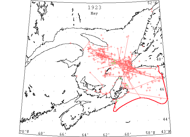
May 1 At least two of the passenger liners which were bound to Montreal and held up by ice conditions in the Cabot Straits, are coming to Halifax to disembark their passengers. (HH 01/05/1923 p12#2)
May 1 North Sydney, the French trawler “La Provence” with her propeller gone, was still fast in the ice about forty miles off Louisburg. [this is probably an incorrect estimation ignoring the correction for Paris longitude] (HH 02/05/1923 p13#5)
May 1 North Sydney, the steamer “Kyle,” fast in the ice off St. Paul’s with her propeller damaged, indicates that there has been no change in the position of the ship or the general ice conditions in the area. “Cymric Queen,” aground on Black Breakers, Point St. Esprit, Cape Breton, reported this morning that ice and weather conditions had undergone no change since yesterday. The ice has not affected the position of the ship and she is still water tight. (HH 02/05/1923 p13#6)
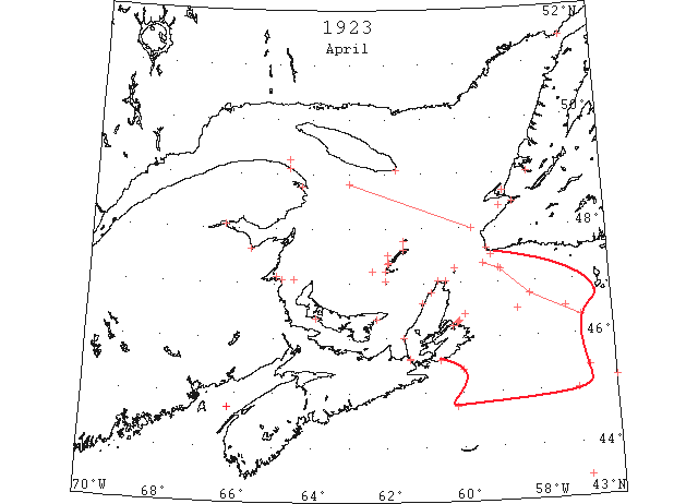
May 1 An impenetrable barrier of Gulf and coast ice has been flung across the Cabot Strait. The central entrance to the Gulf of St. Lawrence and estimates based on reports received are that it will be at least 5 days before navigation is open throughout this gateway to Quebec and Montreal. The other entrances, the Straits of Belle Island and Strait of Canso are also closed by a great field of ice that lies in the Gulf to the north and is pressing for exit through Cabot Strait. Conditions in Cabot Strait are said to be exceptional. From the Gulf a heavy north east gale is aiding currents to throw a big jam into Cabot Strait and from the Atlantic south and south west gales are driving drift pans and small bergs against the Cape Ray shore of Newfoundland. On the one side practically the whole weight of what ice is left in the Gulf is exerting pressure outwards and on the other a mass of pans of heavy ice ranging up to 30 feet in thickness is being forced inwards. These fields extend from a point some miles off Cape Canso on the Nova Scotia side and Cape Race on the Newfoundland side. The whole bite north and west of this line is packed with drift ice and the southwesterly wind is throwing it steadily off the Nova Scotia coast upward and inward. In the great area from the southern fringe in the Atlantic to the north fringe in the Gulf, a terrific battle of the elements is going on. Where the jam is heaviest and pressure strongest, the floating menace is being ground into slob but the jam itself is like a wall of iron and stone to steamers on either side. The ice breaker “Montcalm” from Quebec is reported to be having an exceptionally difficult time in the Cabot Straits. (Pat 1 May p1 c5)
May 1 Louisburg, N.S.: close-packed ice off this port. Point Amour: light close-packed ice everywhere. Belle Isle: heavy close-packed ice everywhere, twelve bergs. (HB 1757 May 9 CSS)
May 1 SS “Canadian Squatter” 48°40’N 60°12’W: steaming southward along heavy packed ice field. (HB 1757 May 9)
May 1 SS “Canadian Forrester” 45°39’N 56°47’W: very heavy, large, close-packed ice. (HB 1757 May 9)
May 1 CGS “Montcalm”: reports heavy open ice; southward of Heath Point, heavy close-packed ice. (HB 1757 May 9 CSS)
May 1 SS “Botingbroke: reports heavy close-packed ice from Henry Island to Cape George and along the southern coast of Prince Edward Island to Prin Point; [Northumberland] Straits generally open and easily navigated. (HB 1757 May 9 CSS)
May 1 SS “Horda 48°10’N 60°10’W: ice soft and much broken. (HB 1757 May 9 CSS)
May 1 SS “Manchester Spinner” 46°10’N 55°30’W: encountered field ice. (HB 1759 May 23)
May 1 SS “Seattle Spirit” 45°10’N 55°18’W: narrow fields of drift ice extending east and west; 46°30’N 57°20’W, heavy drift ice with occasional leads. (HB 1761 Jun 6)
May 1 French trawler “La Province”: “In communication with S.S. “Canada” ascertained that she had reached distressed trawler “La Province” 45°30[03?]’N 56°30’W through very heavy ice, that she had taken off the passengers and that master and crew had refused to leave the vessel. Master of “Canada” advised that towing “La Province” was impractical and that in his opinion small vessel could not reach her under present ice conditions.” (from cruise report of Captain William J. Wheeler of the U.S. Coast Guard Cutter “Tampa”, dated May 2, 1923, entitled ‘Report of Second Ice Patrol cruise, April 17-May 2, 1923’, addressed to the Commandant, U.S. National Archives and Records Administration, Record Group 37, Hydrographic Office, General Correspondence, 1907-1924, Box 150, Ice Patrol Ships Reports, File 261511/2995psr, Item 2, p. 8)
May 1 French trawler “La Province”: [Message from SS] “”Canada” I found the “La Province” approximately 45°03’N 56°30’W. Approach[ed] from the north. She listing in large ice field five miles deep with thirty miles of scattered ice to get through before that. Coming to the southwest broke about three miles of heavy ice and five miles of loose ice with big growlers. Unless conditions change I do not think any small vessel could get through unless very powerful. Towing would be impossible under those conditions. My time was too valuable even to try. Considered his refusal of being taken off was sufficient even if his story of having only five buckets of coal was true. Passengers will be landed at Halifax tomorrow. Signed, Smith.” (from cruise report of Captain William J. Wheeler of the U.S. Coast Guard Cutter “Tampa”, dated May 2, 1923, entitled ‘Report of Second Ice Patrol cruise, April 17-May 2, 1923’, addressed to the Commandant, U.S. National Archives and Records Administration, Record Group 37, Hydrographic Office, General Correspondence, 1907-1924, Box 150, Ice Patrol Ships Reports, File 261511/2995psr, Item 2, p. 12)
May 2 First arrival of season at Quebec. (WBB)
May 2 The stations of the Canadian Signal Service reported ice as follows: Magdalen Islands, open ice as far as can be seen; Money Point, open ice distant; Cape Ray, heavy close packed ice distant; stationary. (NYMR, p.13, col.3)
May 2 Three liners were bound to Quebec and Montreal but could not break through the ice barrier that closed the Cabot strait to navigation, consequently they were obliged to come to Halifax. (HH 03/05/1923 p11#3)
May 2 CGS “Montcalm” 48°00’N 60°35’W: ice much softer. (HB 1757 May 9 CSS)
May 2 SS “Manchester Reporter”: off Cape Ray, ice soft with patches of open water; Grosse Isle, light open ice; and off Old Harry, close-packed ice as far as could be seen. (HB 1757 May 9 CSS)
May 2 CGS “Montcalm” 48°00’N 60°30’W: reports (2 p.m.), patches of open water as far as can be seen; Magdalen Islands, open and close-packed ice; Money Point, heavy open ice distant (11.55 a.m.). (HB 1757 May 9 CSS)
May 2 SS “Manchester Regiment”: about 35 miles NNW (mag.) from Cape Ray large patches of open water and heavy ice which is softening considerably. (HB 1757 May 9)
May 2 CGS “Montcalm” 48°55’N 60°40’W: (8 p.m.), numerous large patches open water; West Point, M.I., open ice about 10 miles off; Étang du Nord and Old Harry, dense fog. (HB 1757 May 9 CSS)
May 2 SS “Trondjemsfjord” 47°32’N 60°07’W: heavy field ice, very little open water. (HB 1757 May 9)
May 2 SS “Manchester Regiment” 48°N 60°20’W: (6.15 p.m.), heavy ice. (HB 1757 May 9)
May 2 SS “Horda” 48°14’N 61°12’W: (6.15 p.m.), large rafts of heavy, unbroken ice, impossible to break. (HB 1757 May 9)
May 2 Magdalen Islands: heavy open ice as far as can be seen. Cape Ray: heavy, close-packed ice distant, stationary. Money Point: open ice distant. (HB 1758 May 16 CSS)
May 2 SS “Seattle Spirit” 46°25’N 57°50’W: heavy drift ice as far as can be seen. (HB 1761 Jun 6)
May 3 CGS “Montcalm”: 47°56’N 60°40’W to 47°53’N 61°36’W, very little open ice; thence to 48°22’N 61°39’W, very little ice as far as can be seen; and 47°58’N 60°50’W, ice much softer and broken. (HB 1757 May 9 CSS)
May 3 SS “Horda” 49°11’N 63°12’W: ice soft and much broken. [Report by radio from Cape Race.] (HB 1757 May 9)
May 3 SS “Minnedosa” 46°48’N 57°09’W: ice much softer. [Report by radio from Cape Race.] (HB 1757 May 9)
May 3 SS “Bawtry” 48°07’N 60°25’W: heavy ice to westward with apparently no clear passage. [Report by radio from Cape Race.] (HB 1757 May 9)
May 3 Heath Point: heavy, close-packed ice distant. Point Escuminac: light open ice inshore. Magdalen Islands: heavy open ice as far as can be seen. St. Paul Island: heavy close-packed ice everywhere. Cape Ray: heavy, close-packed ice distant, stationary. Flat Point: heavy close-packed ice distant. Louisburg, N.S.: close-packed ice off this port. Point Amour: light close-packed ice everywhere. Belle Isle: heavy close-packed ice everywhere. (HB 1758 May 16 CSS)
May 3 SS “Horda”: from 48°50’N 63°00’W: open ice. The western limit of ice was in a line between Cap des Rosiers and Southwest Point, Anticosti. (HB 1759 May 23)
May 3 SS “Seattle Spirit” 46°10’N 57°50’W: heavy drift ice as far as can be seen. (HB 1761 Jun 6)
May 4 Flat Point, heavy closely packed ice moving to south; Money Point, heavy closely packed ice south and east moving to north west; Cape Ray, heavy closely packed ice everywhere, moving to north west; St Paul’s Island, heavy closely packed ice everywhere, moving to south and east. (HH 05/05/1923 p20#1)
May 4 The first schooner to reach Charlottetown this spring was the “Lady May” which arrived today from Pinette. The vessel reported lobstermen running their lines. (Pat 4 May p5 c3)
May 4 Heath Point: heavy, close-packed ice distant. Magdalen Islands: Étang du Nord, ice offshore 16 miles westward of West Point, heavy open ice 12 miles offshore; Grosse Isle, light open ice; Old Harry, ice as far as can be seen. St. Paul Island: heavy close-packed ice everywhere. Flat Point: heavy close-packed ice distant. Money Point: heavy close-packed ice. Belle Isle: heavy close-packed ice everywhere; 10 bergs. (HB 1758 May 16 CSS)
May 4 SS “Seattle Spirit” 46°00’N 57°40’W: reports heavy ice to westward as far as can be seen. [Reported from Cape Race.] (HB 1758 May 16)
May 4 CGS “Montcalm” 48°35’N 61°17’W: reports heavy open ice; Sydney Harbour, full of loose, scattered ice as far as can be seen; Étang du Nord, ice offshore about 10 miles westward; West Point, M.I., heavy open ice 12 miles offshore; Grosse Isle, light open ice moving westerly; Old Harry, ice as far as can be seen. (HB 1758 May 16 CSS)
May 4 [an unnamed] steamer: 15 miles off Cape Ray stopped by close-packed ice, another (May 3, 8.30 p.m.) 7 miles off surrounded by close-packed ice. (HB 1758 May 16)
May 4 SS “Canadian Victor” 48°28’N 61°00’W: reports close-packed ice. [Reported from Cape Race.] (HB 1758 May 16)
May 4 SS “Oxonian” 47°51’N 59°48’W: ice impassable; cannot move in any direction; three other steamers in sight, apparently also jammed. [Reported from Cape Race.] (HB 1758 May 16)
May 4 CGS “Montcalm”: 47°44’N 59°51’W to 47°55’N 60°25’W, heavy close-packed ice; Cape Ray, St. Paul Island, Money Point, and Flat Point, heavy close-packed ice; Sydney, heavy open ice in harbour; Grosse Isle, heavy open ice; Old Harry and West Point, close-packed ice as far as can be seen; Étang du Nord, heavy open ice about 10 miles to the westward. [Report by Cape Race.] (HB 1758 May 16 CSS)
May 4 SS “Benguela”: jammed in heavy close-packed ice off Cape Ray. [Report by Cape Race.] (HB 1758 May 16)
May 4 SS “Regina” 47°04’N 57°32’W: heavy broken field ice to 48°00’N 61°20’W; thence occasional patches of field ice to 48°36’N 61°20’W; thence to 48°56’N 63°38’W, heavy packed ice. (HB 1759 May 23)
May 4 SS “Seattle Spirit” 46°15’N 58°30’W: ice more heavily packed, due to east wind. (HB 1761 Jun 6)
May 5 Sydney, five unarmed steamers are jammed fast in the ice of Cape Ray according to a report received here this morning and the “Kyle” is reported to have changed position from eight miles east of Flat Point to ten miles north-north-east of that point during the night. (HH 07/05/1923 p11#3)
May 5 The pressure on the ice jam in Cabot Strait and the area south between Cape Breton and Newfoundland shows no indication of lessening and indications are that the barrier is widening. (Pat 5 May p1 c7)
May 5 Owing to the ice around the Island shore, lobster fishing has been seriously interfered with. Lines have been run from Cape Bear to East Point and some along the south but few on the north side. The schooner “J.H. Ernest” has the distinction of being the first craft out of Summerside harbour this year sailing on May 5th for Pictou. (Pat 10 May p8 c3)
May 5 Magdalen Islands: Grosse Isle, light open ice, moving westerly; West Point and Old Harry, heavy close-packed ice. St. Paul Island: heavy close-packed ice. Flat Point: heavy close-packed ice distant. Money Point: heavy close-packed ice inshore. Belle Isle: heavy close-packed ice everywhere; 10 bergs. (HB 1758 May 16 CSS)
May 5 The following radiogram [was] received from the U.S. Coast Guard Cutter on patrol [US CGC “Modoc”]: St. Lawrence field extends from Canso to 45°10’N 55°40’W, thence to St. Pierre. (HB 1758 May 16 CSS)
May 5 SS “Seattle Spirit” 46°19’N 58°27’W: jammed in heavy close-packed ice. (HB 1761 Jun 6)
May 6 Heavy close packed ice from eight miles north of Canso across to a point off Besque [Basque] Island, then east as far as can be seen. One steamer apparently jammed in ice was seen off Canso. (HH 07/05/1923 p14#1)
May 6 CGS “Montcalm” 47°40’N 60°10’W: heavy close-packed ice; Magdalen Islands, off Old Harry and Grosse Isle, heavy open ice; Étang du Nord, open ice about 6 miles off. [Report by Cape Race.] (HB 1758 May 16 CSS)
May 6 SS “Saturnia” 47°44’N 59°47’W: ice very heavy and solid. [Report by Cape Race.] (HB 1758 May 16)
May 6 SS “Welshman” 47°52’N 59°28’W: heavy open ice with patches of open water. [Report by Cape Race.] (HB 1758 May 16)
May 6 SS “Oxonian” 47°52’N 59°55’W: jammed in heavy packed ice. [Report by Cape Race.] (HB 1758 May 16)
May 6 SS “Minnedosa”: clear thence to 46°35’N 55°31’W, where growlers and small pieces of ice were passed; 46°47’N 56°48’W, heavy field ice; thence to 60°west, heavy close-packed ice; between longitudes 60°and 61°W, heavy ice. (HB 1758 May 16)
May 6 SS “Seattle Spirit” 46°09’N 58°48’W: open water. (HB 1761 Jun 6)
May 6 SS “Donax” 46°22’N 60°30’W: heavy drift ice. (HB 1763 Jun 20)
May 7 SS “Harland” will commence her regular trips to Orwell next Monday and Tuesday (7th and 8th). (Pat 5 May p5 c5)
May 7 Grindstone, M.I.: West Point, scattered ice. Cape Tormentine: heavy open ice. Flat Point: heavy close-packed ice everywhere. (HB 1758 May 16 CSS)
May 7 CGS “Montcalm” 47°32’N 60°05’W: heavy close-packed ice; South Point, Anticosti Island, close-packed ice; Grindstone Island, West Point, open ice 5 or 6 miles offshore. (HB 1758 May 16 CSS)
May 7 SS “Canadian Sapper”: Off Flat Point, heavy close-packed ice. (HB 1758 May 16)
May 7 SS “Welland County” 47°44’N 60°30’W: ice softer; patches of clear water. (HB 1758 May 16)
May 7 SS “Marvale” 49°40’N 59°40’W: icebound since 10 p.m. yesterday; heavy close-packed ice in all directions. (HB 1758 May 16)
May 7 SS “Crenatula”: 15 miles northward of Cpe Anguille, clear water east and west as far as can be seen. (HB 1758 May 16)
May 7 SS “Vistula”: 1 mile south of Green Island: Heath Head and Cape Hogan free of ice; northern edge of ice reaching toward Cape Argos, ice drifting apparently southeastward. [Reported by Cape Race.] (HB 1758 May 16)
May 7 CGS “Montcalm” 47°10’N 59°42’W: heavy close-packed ice. Sydney Harbour full of loose ice as far as can be seen; South Point, Anticosti, heavy close-packed ice; Cape Ray, heavy close-packed ice. [Reported by Cape Race.] (HB 1758 May 16 CSS)
May 7 SS “Saturnia” 47°49’N 59°50’W: jammed in heavy ice; 48°02’N 60°01’W, heavy field ice. [Reported by Cape Race.] (HB 1758 May 16)
May 7 SS “Welshman” 47°00’N 59°37’W: heavy close-packed ice in all directions. [Reported by Cape Race.] (HB 1758 May 16)
May 7 SS “Regina” 47°58’N 60°58’W: ice still heavy and close packed. [Reported by Cape Race.] (HB 1758 May 16)
May 7 SS “Ariano” 46°50’N 59°31’W: heavy packed ice. [Reported by Cape Race.] (HB 1758 May 16)
May 7 SS “Benguela” 47°45’N 60°11’W: jammed in very heavy close-packed ice. [Reported by Cape Race.] (HB 1758 May 16)
May 7 SS “Oxonian” 48°06’N 60°44’W: clear water; from 48°58’N 60°18’W, to 48°04’N 60°39’W, closely packed ice, with occasional patches of water. [Reported by Cape Race.] (HB 1758 May 16)
May 7 SS “Crenatula” 47°20’N 60°38’W: heavy open ice. [Reported by Cape Race.] (HB 1758 May 16)
May 7 SS “Canadian Carrier” 47°51’N 59°55’W: jammed in heavy close-packed ice. [Reported by Cape Race.] (HB 1758 May 16)
May 7 a[n unnamed] steamer, 47°32’N 60°12’W, fast in ice. [Reported by Cape Race.] (HB 1758 May 16)
May 7 SS “Bruton” 48°00’N 60°20’W: heavy ice. [Reported by Cape Race.] (HB 1758 May 16)
May 7 SS “Saturnia” 48°02’N 60°30’W: (6 p.m.), ice conditions improved. [Reported by Cape Race.] (HB 1758 May 16)
May 7-11 SS “Donax” 46°59’N 59°45’W: heavy pack ice; vessel unable to proceed until May 11. (HB 1763 Jun 20)
May 8 CGS “Brant” was expected to reach Charlottetown today from her winter quarters in Georgetown but was unable to get beyond the ice barrier which still lies between Panmure Island and Cape Bear. (Pat 8 May p5 c6)
May 8 CGS “Montcalm”: close east of St. Paul Island, heavy open ice; Étang du Nord, close-packed ice; Money Point, heavy close-packed ice. (HB 1758 May 16 CSS)
May 8 SS “Athenia” 47°27’N 59°43’W: stopped in heavy ice fields. (HB 1758 May 16)
May 8 SS “Welshman” 47°23’N 59°43’W: stopped in very heavy close-packed ice; had several patches of thin ice and open water from 47°00’N 59°37’W. (HB 1758 May 16)
May 8 SS “Bruton” 48°00’N 60°30’W: ice much softer and broken. (HB 1758 May 16)
May 8 SS “Berwyn” 48°19’N 59°33’W: jammed in heavy rafts of close-packed ice. (HB 1758 May 16)
May 8 SS “Ariano”: same position [46°50’N 59°31’W presumably], unable to move. (HB 1758 May 16)
May 8 a[n unnamed] steamer, 47°56’N 59°41’W, soft ice. (HB 1758 May 16)
May 8 SS “Valacia” 47°07’N 58°00’W: no ice at present. (HB 1758 May 16)
May 8 SS “Ausonia” 46°36’N 56°40’W: loose field ice; 47°06’N 58°08’W, loose scattered ice field. (HB 1759 May 23)
May 8 SS “Seattle Spirit”: entrance to Chedabucto Bay blocked by ice. (HB 1761 Jun 6)
May 8 SS “Seattle Spirit”: off Cape George, Northumberland Straits, packed ice. (HB 1761 Jun 6)
May 9 The snow is fast disappearing and a few days hot sun would now take it all away. The brooks have opened up and it is hoped in a few days the Humber will be clear of ice. (TWS, p.2).
May 9 On Sunday twelve passengers and thirteen of the crew of the SS “Kyle” traveled ashore at North Sydney. The ship was then jammed in the ice off Low Point and was running short of provisions and coal. The men traveled over the ice thirteen miles and reached the shore in dories. (TWS, p.2)
May 9 The government ice breakers “Stanley” and “Montcalm” are being rushed to St. Paul’s Island Light. The “Montcalm” has been endeavouring to reach St. Paul’s Island for two days. (Pat 9 May p1 c5)
May 9 The Newfoundland steamer “Kyle” which sailed more than a fortnight ago from Newfoundland for North Sydney, reached here this morning after being stuck in ice with propeller trouble for 12 days. Twenty-seven of her passengers crossed the ice to shore yesterday and the ice barrier broke up a few hours later. (Pat 9 May p1 c5)
May 9 The outlook for the lobster fishing season along the North Shore of the Gulf of St. Lawrence is not as high as 10 days ago. The NE winds of last week have blocked the shore with ice again. (Pat 9 May p7 c3)
May 9 CGS “Montcalm”: St. Paul Island, heavy close-packed ice as far as can be seen; Étang du Nord, heavy open ice; West Point, ice about 4 miles offshore; Old Harry, ice distant; Sydney, heavy open ice. (HB 1758 May 16 CSS)
May 9 SS “Donax” 47°35’N 59°45’W: heavy close-packed ice. [Reported by Cape Race.] (HB 1758 May 16)
May 9 SS “Domira” 47°32’N 59°23’W: close, soft ice. [Reported by Cape Race.] (HB 1758 May 16)
May 9 SS “Marvale” 47°59’N 59°54’W: ice changed. [Reported by Cape Race.] (HB 1758 May 16)
May 9 A[n unnamed] steamer 47°25’N 60°14’W: solid, heavy ice. [Reported by Cape Race.] (HB 1758 May 16)
May 9 SS “Athenia” 47°27’N 59°43’W: jammed in very heavy ice. [Reported by Cape Race.] (HB 1758 May 16)
May 9 SS “Ariano” 46°55’N 59°22’W: heavy packed ice, unable to move. [Reported by Cape Race.] (HB 1758 May 16)
May 9 SS “Oxonian” 47°18’N 58°55’W: had clear water and turning into heavy field open ice. [Reported by Cape Race.] (HB 1758 May 16)
May 9 SS “Burton” 48°38’N 62°00’W: open field ice. [Reported by Cape Race.] (HB 1758 May 16)
May 9 CGS “Montcalm” 46°32’N 60°00’W: heavy close-packed ice as far as can be seen. Québec Signal Service reports: Anticosti Southwest Point, light open ice distant; South Point, close-packed ice distant; Magdalen Islands, open ice distant; Money Point, close-packed ice eastward and southward; Souris, P.E.I., scattered ice; St. Paul Island and Flat Point, heavy close-packed ice; Sydney reports open ice in the harbour; close offshore the ice appears heavy; Magdalen Islands, West Point, open ice about 3 miles offshore; Étang du Nord, open ice; Old Harry and Grosse Isle, scattered ice. [Reported by Cape Race.] (HB 1758 May 16 CSS)
May 9 SS “Empress of Scotland”: reports 6 p.m. (10 miles 178° from Cape Ray) that a fringe of broken ice field skirts the heavy-packed ice from 3 miles off Cape Ray to 12 miles SSE.; to the northwest of Cape Ray there is an open area of 12 miles. [Reported by Cape Race.] (HB 1758 May 16)
May 9 SS “Armando” 47°15’N 59°49’W: heavy close-packed ice in all directions. [Reported by Cape Race.] (HB 1758 May 16)
May 9 SS “Domira” 47°45’N 59°45’W: jammed in heavy packed ice. [Reported by Cape Race.] (HB 1758 May 16)
May 9 SS “Saturnia” 49°05’N 63°30’W: clear of ice; 48°40’N 62°49’W, open ice and broken field ice. [Reported by Cape Race.] (HB 1758 May 16)
May 9 SS “Caledonain”: at 8.30 p.m. passed Cape Ray, soft open ice; 2 hours later stopped in close-packed ice and unable to proceed. [Reported by Cape Race.] (HB 1758 May 16)
May 9 SS “Welshman” 47°23’N 50°43’W: very heavy close-packed ice. [Reported by Cape Race.] (HB 1758 May 16)
May 9 SS “Marvale” 48°02’N 59°32’W: heavy packed ice with opening spaces; conditions improving. [Reported by Cape Race.] (HB 1758 May 16)
May 9 SS “Armando” 47°15’N 59°39’W: heavy packed ice in all directions. [Reported by Cape Race.] (HB 1758 May 16)
May 9 SS “Ariano” 47°15’N 59°50’W: stopped in heavy packed ice. [Reported by Cape Race.] (HB 1758 May 16)
May 9 SS “Berwyn” 48°18’N 59°32’W: in heavy close-packed ice. [Reported by Cape Race.] (HB 1758 May 16)
May 9 The following radiogram [was] received from the U.S. Coast Guard Cutter on patrol [US CGC “Modoc”]: St. Lawrence ice fields extend from Cape Breton to 45°20’N 56°0’W, thence to Miquelon. (HB 1758 May 16)
May 9 SS “Ausonia” 47°25’N 59°10’W: heavy ice. About 10 miles west from Cape Ray jammed in heavy ice field. (HB 1759 May 23)
May 10 “Cassandra” entered open ice field 10 miles off St. Pierre. (IIP p67)
May 10 Southern entrance to [Cabot] Strait: blocked with heavy ice. Heavy close-packed ice from St. Paul Island to Low Point. [Reported by Cape Race.] (HB 1758 May 16 CSS)
May 10 SS “Empress of Scotland: ice apparently closing on Cape Ray, setting southeastward; edge of field much broken by heavy packed ice. [Reported by Cape Race.] (HB 1758 May 16)
May 10 SS “Marvale” 48°05’N 59°39’W: heavy packed ice; impassable. [Reported by Cape Race.] (HB 1758 May 16)
May 10 SS “Ariano” 47°15’N 59°47’W: heavy packed ice. [Reported by Cape Race.] (HB 1758 May 16)
May 10 Sydney: heavy ice outside. [Reported by Cape Race.] Grindstone and Étang du Nord: heavy open ice. Old Harry: scattered ice as far as can be seen. Québec: South Point, Heath Point, Anticosti, and Money Point, heavy close-packed ice everywhere; Magdalen Islands, open ice; Cape Ray, close-packed ice distant; Port Hood, Souris, and Cheticamp, close-packed ice; Flat Point, heavy open ice everywhere. (HB 1758 May 16)
May 10 CGS “Montcalm”: (8 p.m.) Sydney Harbour clear of ice; clear also as far as Low Point. [Reported by Cape Race.] (HB 1758 May 16 CSS)
May 10 SS “Donald” 46°55’N 59°43’W: heavy close-packed ice; Grindstone, heavy open ice, distant; West Point, close-packed ice; Grosse Isle, scattered ice distant; Old Harry, light open ice distant. (HB 1758 May 16)
May 10 SS “Domira”: 1 a.m., heavy ice S. 78° E. 10 miles from Cape Anguille. [Reported by Cape Race.] (HB 1758 May 16)
May 11 Southern entrance to Strait of Canso filled with light open ice. [Reported by Cape Race.] (HB 1758 May 16)
May 11 CGS “Montcalm” 46°34’N 60°15’W: (8 p.m.) heavy close-packed ice to Low Point. (HB 1759 May 23 CSS)
May 11 Heath Point, heavy close-packed ice everywhere; Magdalen Islands-Étang du Nord, close-packed ice; Grosse Isle, scattered ice; Old Harry, ice as far as can be seen; West Point, open ice about 4 miles off Alfred Noble. (HB 1759 May 23)
May 11 A[n unnamed] steamer 46°18’N 59°46’W: jammed in heavy ice unable to proceed. (HB 1759 May 23)
May 11 SS “Domira”: (7.15 p.m.) about 30° from Cape Ray, drifting north in heavy ice. (HB 1759 May 23)
May 11 SS “Cairnvalona” 47°10’N 59°18’W: (7.30 p.m.) loose open-field ice. (HB 1759 May 23)
May 11 SS “Kenbane Head”: (6.00 p.m.) Cape Ray bearing 7°, 4 miles, scattered field ice. (HB 1759 May 23)
May 12 Money Point, no ice. Flat Point, heavy open ice moving southeast. (HH 14/05/1923 p14#1)
May 12 CGS “Montcalm”: (8.30 a.m.) heavy close-packed ice from Flat Point to St. Paul Island; Magdalen Islands – Grosse Island, no ice in sight; Old Harry, distant open ice; Étang du Nord, loose ice; West Point, open ice; Sydney, scattered ice. (HB 1759 May 23 CSS)
May 12 SS “Bedwyn” 47°52’N 60°28’W: (7.40 a.m.) course 296°, 10 miles of clear water. (HB 1759 May 23)
May 12 SS “Cassandra” 47°20’N 59°29’W: (7.00 a.m.) course since yesterday noon 287° 96 miles; passed through heavy ice with large clear spaces; now in heavy open ice. (HB 1759 May 23)
May 12 SS “Donax” 47°13’N 59°51’W: (8.00 a.m.) open ice. (HB 1759 May 23)
May 12 SS “Valacia” 48°19’N 60°30’W: (10.45 p.m.) passing through heavy field ice with much difficulty. (HB 1759 May 23)
May 12 SS “Caledonia”: (4 p.m.) jammed in heavy packed ice with Cape Anguille bearing 140°, distant 15 miles. (HB 1759 May 23)
May 12 SS “Kenbane Head” 47°42’N 59°42’W: (7.30 a.m.) loose field ice. (HB 1759 May 23)
May 12 SS “Marvale” 49°36’N 62°10’W: (5.25 a.m.) in heavy field ice, extending north and west; clear water to the southward; at 2 p.m., 47°38’N 59°36’W, heavy open ice to St. Paul Island; ice seems lighter toward Cape Ray and Cape Anguille and much opened. (HB 1759 May 23)
May 12 Saguenay River clear of ice; Cape St. Lawrence, ice distant; Flat Point, heavy open ice, distant. General conditions in the Gulf improving. Heath Point and South Point, Anticosti, heavy open ice. Étang du Nord, heavy open ice (HB 1759 May 23)
May 12 SS “Armando” 47°38’N 60°01’W: at noon, jammed in heavy broken ice. (HB 1759 May 23)
May 12 CGS “Montcalm”: (8.45 p.m.) St. Georges Bay, heavy close-packed ice; from Codroy in all directions heavy close-packed ice. (HB 1759 May 23 CSS)
May 12 SS “Pennsylvania” 47°18’N 59°50’W: (3 p.m.) in heavy field ice with some open water (HB 1759 May 23)
May 12 SS “Bedwyn” 48°22’N 61°18’W: (noon) open water as far as can be seen. (HB 1759 May 23)
May 12 SS “Andania” 47°39’N 59°35’W: (7.30 p.m.) ice field extending north and south as far as can be seen. (HB 1759 May 23)
May 12 SS “Cairnmona”[sic = “Cairnvalona”] 48°08’N 61°01’W: (6.30 p.m.) open water to the southwest; clear heavy field ice in 48°00’N 60°28’W. (HB 1759 May 23)
May 12 Sydney Harbour full of loose ice; appears heavier and closely packed off Low Point. (HB 1759 May 23 CSS)
May 12 Magdalen Islands-Étang du Nord, open ice; Plate Point, ice field 6 miles 242°, with its northern limit at 46°48’N, and extending south as far as can be seen; between 56°44’W and 56°32’W, about 8 miles heavy and broken ice, clear water then to 47°07’N 59°00’W; thence to a point 5 miles north of St. Paul Island, thence to 48°00’N 60°30’W, heavy open-field ice; thence to 48°20’N 62°00’W, scattered ice and large stretches of open water; thence to 49°00’N 63°43’W, softening open ice field with numerous growlers and occasional lanes of open water. (HB 1759 May 23 CSS)
May 12 Point Amour: heavy open ice, distant. (HB 1759 May 23 CSS)
May 12 CGS “Stanley”: heavy close-packed ice from Flat Point to Flint Island. (HB 1759 May 23 CSS)
May 12 SS “Megantic”: from 46°52’N 56°35’W to 46°56’N 57°30’W, patch of field ice; from 47°17’N 58°01’W to 47°13’N 58°09’W, scattered ice; from 47°18’N 58°31’W to 47°39’N 59°38’W, heavy open ice; from 47°33’N 59°44’W to 48°02’N 60°32’W, heavy open ice; off Cape Ray, a field of 7 miles extent. (HB 1759 May 23)
May 12 SS “Virgilia” 48°03’N 59°41’W: heavy ice with open patches; [from] 48°20’N 60°27’W to 48°41’N 62°06’W, open water; thence to 48°49’N 62°35’W, heavy packed ice. (HB 1759 May 23)
May 12 SS “Bothwell” 46°45’N 56°31’W: passed through a strip of about 4 miles light scattered field ice, then clear water. (HB 1760 May 30)
May 13 CGS “Montcalm” 48°01’N 59°19’W: (8.00 a.m.) heavy close-packed ice in all directions. (HB 1759 May 23 CSS)
May 13 SS “Donax”: (8.00 p.m.) ten miles east of St. Paul Island very heavy close-packed ice. (HB 1759 May 23)
May 13 SS “Bedwyn” 47°00’N 59°38’W: (9.00 a.m.) stopped in thick, heavy ice. (HB 1759 May 23)
May 13 SS “Caledonia” 47°10’N 60°09’W: (8.00 a.m.) open water with heavy patches of ice as far as can be seen. (HB 1759 May 23)
May 13 SS “Cassandra” 48°19’N 59°58’W: (9.00 p.m.) since 7 a.m. course 288°, distant 22 miles, passed through heavy open ice; the ice now is moderately heavy and open. (HB 1759 May 23)
May 13 CGS “Montcalm” 48°09’N 59°30’W: (2 p.m.) heavy packed and broken ice. (HB 1759 May 23 CSS)
May 13 SS “Bedwyn” 46°54’N 59°35’W: (1 p.m.) heavy packed ice. (HB 1759 May 23)
May 13 A[n unnamed] steamer: 3 miles NNW. of Cape Anguille, heavy ice. (HB 1759 May 23)
May 13 SS “Epidauro” 48°20’N 59°35’W: heavy packed ice; cannot proceed. (HB 1759 May 23)
May 13 SS “Bothwell” 47°36’N 59°29’W: (8 p.m.) stopped in field ice; clear water to the northwest and north as far as can be seen. (HB 1759 May 23)
May 13 SS “Andania” 47°42’N 59°30’W: heavy packed ice extending in a 40° and 200° direction; 48°19’N 61°52’W, passed a patch of field ice extending north; 48°22’N and between 62°03′ and 62°27’W, heavy field ice to the northward; cleared all ice at 49°50’N 62°20’W. (HB 1759 May 23)
May 13 SS “Megantic”: 40[48?]°25’N 62°17’W to 49°00’N 63°30’W, large field of heavy open ice. (HB 1759 May 23)
May 13 SS “Kenbane Head”: about 6 miles south of Plate Point, field ice; from Cape Ray to 47°50’N 60°30’W, heavy open field ice; and 48°39’N 63°28’W, loose field ice. (HB 1759 May 23)
May 13 SS “Cassandra”: from 9 miles southward of St. Pierre to 46°10’N 59°18’W, fields of loose, light, heavy, and close-packed ice with large clear spaces; thence to 47°29’N 60°10’W, heavy close-packed ice; 48°23’N 62°15’W, heavy loose ice for about 10 miles. (HB 1759 May 23)
May 13 SS “Pennsylvania” 48°39’N 62°30’W: scattered ice. (HB 1759 May 23)
May 13 SS “Bedwyn”: 45°33’N 58°38’W to 48°06’N 60°52’W, heavy ice; from 48°32’N 60°59’W to 48°27’N 62°36’W, extensive ice fields with open lanes and many dangerous growlers. (HB 1759 May 23)
May 13 SS “Bally Gally Head” 46°33’N 55°36’W: ice field; 46°36’N 57°06’W: ice field extending east and west to the horizon, northern edge in 46°33’N; in 47°12’N 58°21’W, heavy packed ice extending 5 miles to the westward. (HB 1759 May 23)
May 13 SS “Cairnavon”[sic = “Cairnvalona”]: about 20 miles southwest from Miquelon Island heavy close-packed ice, not navigable; about 6 miles 300° from Cape Ray, heavy close-packed ice; cleared this ice in 47°56’N 60°20’W. (HB 1759 May 23)
May 13 SS “Albertolite” 45°54’N 61°50’W: passed through heavy scattered field ice. (HB 1760 May 30)
May 13 SS “Bothwell”: off Port [aux] Basques, about 2 miles scattered ice with heavy field ice to St. Paul Island. Open water from Cape Ray 10 miles 295°. From 49°43’N 59°30’W to 47°53’N 60°10’W, heavy packed ice in all directions; thence to 48°00’N 60°30’W, scattered light ice. (HB 1760 May 30)
May 14 The first vessel of the season came through from St. Lawrence ports and shortly thereafter one or more Canadian patrol vessels were stationed in the Cabot Straits. (IIP p62)
May 14 St. Lawrence port now open to navigation. Sydney and Louisburg clear of ice. (NYMR, p.13, col.3)
May 14 Ice conditions in the Northumberland Straits, off Little Sands and Pictou Island, is considered very serious for the fishermen. Many of the fishermen set lines some days ago when the Gulf was clear of ice. The East wind, however, drove in the ice and it is feared a large number of the lines have been carried off by the ice. (HH 4/05/1923 p11#1)
May 14 “Stanley” arrives in Pictou to load for the Magdalene Islands. (Pat 14 May p1 c2)
May 14 The lobster season is open. All lines are now set. (Pat 14 May p5 c2)
May 14 The steamer “Mandell” bound from Cuba to Montreal which had been held by the ice for sometime, anchored off the harbour yesterday. The steamer did not chance entry on account of no buoys being in place. (Pat 14 May p8 c3)
May 14 SS “Regina”: passed southward of an open ice field in 48°53’N 63°42’W; entered ice field in 48°36’N 63°17’W; cleared this field in 48°27’N 63°06’W, clear water to 48°03’N 61°08’W. (HB 1763 Jun 20)
May 14 Strait of Canso and Chedabucto Bay clear of ice. (HB 1759 May 23)
May 14 SS “Montrose”: from about 20 miles east of Cap des Rosiers skirted ice fields in clear water to 14 miles northward of Bird Rock, thence heavy packed ice to Cape Ray, thence clear water passing 10 miles off Plate Point. (HB 1759 May 23)
May 14 CGS “Montcalm” 48°03’N 59°34’W: (8 a.m.) heavy close-packed ice as far as can be seen. Sydney, some scattered ice in the harbour and around Low Point. (HB 1759 May 23 CSS)
May 14 SS “Ravenstone” 47°47’N 59°47’W: (8.30 a.m.) jammed in heavy ice. [Reported by Cape Race.] (HB 1759 May 23)
May 14 SS “Essex County”: (10.35 p.m.) from 12 miles east of Cape Ray had heavy, rotten ice in a belt of 20 miles; heavy open ice in present position of 47°53’N 60°20’W. (HB 1759 May 23)
May 14 SS “Essex County” 48°18’N 61°35’W: extensive ice fields 6 miles to the southward; [from] 48°25’N 61°45’W to 48°28’N 62°40’W, heavy ice fields. (HB 1759 May 23)
May 14 SS “Canadian Fisher”: heavy field and packed ice off Cranberry Island, thence clear water to Cape George, thence scattered ice to Point Prim. (HB 1759 May 23)
May 14 CSG “Mikula”: [from] 48°39’N 63°22’W to 48°26’N 62°37’W, passed through soft, open gulf ice and slob. (HB 1759 May 23 CSS)
May 14 SS “Donax” 48°31’N 62°25’W: encountered open packed ice and passed several large pieces of drift ice to 48°13’N 61°15’W. (HB 1759 May 23)
May 14 CGS “Montcalm” 47°55’N 59°30’W: heavy close-packed ice as far as can be seen. (HB 1759 May 23 CSS)
May 14 Anticosti, South Point, close-packed ice distant; Heath Point, close-packed ice everywhere; Flat Point, heavy open ice; Money Point, no ice in sight. (HB 1759 May 23)
May 14 SS “Bedwyn” 46°47’N 59°37’W: very heavy packed ice. (HB 1759 May 23)
May 14 SS “Domira” 48°04’N 61°10’W: cleared ice; from 48°05’N 59°56’W to this latter position heavy, loose ice. (HB 1759 May 23)
May 14 SS “Epidaura”: about 2 miles northward of Cape Anguille very heavy packed ice; off Friar Cove, heavy packed ice as far as can be seen. Étang du Nord, open ice as far as can be seen. West Point, loose ice 5 to 6 miles offshore. Grosse Isle and Old Harry, open ice. (HB 1759 May 23)
May 14 CGS “Montcalm” 48°02’N 59°37’W: (2 p.m.) very heavy close-packed ice from Cape Anguille to 48°02’N 59°30’W, then much open ice to the present position. (HB 1759 May 23 CSS)
May 14 SS “Adolf” 46°30’N 62°20’W: field ice; thence to 47°20’N 63°30’W, drift ice. (HB 1759 May 23)
May 14 SS “Caledonia” 48°57’N 63°31’W: heavy ice. (HB 1759 May 23)
May 14 SS “Castlemoor” 47°50’N 48°05’W: in 59°35’W, heavy ice thinning to the northward; westward to 48°05’N 60°25’W, ice getting softer and occasional water spaces; thence clear water to 48°30’N 61°05’W, heavy close-packed ice to the north and west. (HB 1759 May 23)
May 15? SS “Megantic” 48°08’N 61°01’W: passed a growler. (HB 1759 May 23) [May be an incorrect date; out of sequence in HB list.]
May 15? SS “Manchester Civilian”: off Cape George, scattered ice. (HB 1760 May 30)
May 15 The cable steamer “Fyrum” arrived in this port this morning after completing repairs to the submarine cable between Wood Islands and Pictou which was damaged by ice. (Pat 15 May p5 c5)
May 15 CGS “Mikula”: about 327°, 18 3/4 miles, from Cape Ray stopped in ice; open water about 2 miles from here as far as can be seen. (HB 1759 May 23 CSS)
May 15 St. Paul Island reports: light close-packed ice distant to the south and southeastward. (HB 1759 May 23 CSS)
May 15 SS “Albertolite” 49°17’N 65°31’W: heavy scattered field ice. (HB 1760 May 30)
May 15 SS “Cairnmona”[sic = “Cairnvalona”]: about 12 miles 290° from Cape Ray a belt of heavy packed ice 25 miles broad; outside Cape Ray, heavy packed ice in two belts; from 8 miles off Bird Rocks, clear water for 45 miles, then a belt of field ice which extends to within 20 miles of Cape Gaspé. (HB 1760 May 30)
May 15 SS “Aalsum”: from Cape Anguille to 48°10’N 60°12’W, heavy close-packed ice; thence to 48°00’N 68°10’W [this position wrong, probably near 48°10’N 61°00’W], heavy open ice; thence to 48°23’N 62°20’W, open water; thence to 48°10’N 63°05’W, open ice; thence to Gaspé, open water. (HB 1760 May 30)
May 15 SS “Rose Castle”: from Guion Island to St. Esprit, scattered ice; from 2 miles east to 14 miles west of Cape George, heavy open ice. (HB 1760 May 30)
May 15 SS “Atholl” 48°55’N 63°35’W: passed out of ice field into clear water. (HB 1760 May 30)
May 15 SS “Domira”: from Cape Ray to 48°00’N 61°00’W, heavy packed ice; thence to 43[48?]°00’N 61°30’W, heavy loose ice; from 48°33’N 62°25’W to 30 miles southeast of Gaspé, heavy packed ice. (HB 1760 May 30)
May 15 CGS “Montcalm”: off Cape Anguille, heavy close-packed ice. (HB 1760 May 30 CSS)
May 15 SS “Songo”: between 44°45’N 60°58’W and 48[44?]°58’N 61°05’W, field ice; off Scatari Island, heavy field ice as far as can be seen. (HB 1760 May 30)
May 15 SS “Regina”: scattered ice field to 47°22’N 59°36’W; thence heavy open field ice to 47°19’N 59°07’W; thence clear water to 47°16’N 58°35’W; thence scattered field ice to 47°10’N 58°08’W; scattered field ice southward of Miquelon Islands. (HB 1763 Jun 20)
May 16 “Thurban” Ice field Gulf of St. Lawrence 46°00’N 57°58’W (IIP p67)
May 16 SS “Briseis” 48°55’N 62°08’W: about 20 miles west and 10 miles south surrounded by ice fields. (HB 1760 May 30)
May 16 SS “Ravenstone” 47°50’N 60°00’W: cleared heavy field ice; heavy open ice to-day from 48°30’N 62°22’W to 48°35’N 62°20’W; thence to 48°15’N 63°10’W. (HB 1760 May 30)
May 16 [SS] “Lord Strathcona”: (8.30 p.m.) cleared ice field 40 miles 100° from Bird Rock. (HB 1760 May 30)
May 16 SS “Rathlin Head”: about 12 miles 290° from Cape Ray, heavy packed ice, and cleared it in 47°51’N 60°18’W; clear water to 48°29’N 62°24’W, where field of loose ice was encountered, which became very heavy in places; cleared this field in 48°45’N 62°02’W; several stray pieces of ice 20 miles east of Cap des Rosiers. (HB 1760 May 30)
May 16 Point Amour: heavy open ice, distant. Belle Isle: heavy open ice everywhere; 18 bergs. (HB 1760 May 30)
May 17 The ice cleared out of the Humber Arm on Sunday. (TWS, p.2)
May 17 SS “Athenia”: 48°45’N 63°15’W to 48°17’N 62°12’W, close-packed but not heavy ice, thence open water to Bird Rocks; 47°21’N 59°33’W, heavy close-packed ice. (HB 1759 May 23)
May 17 Cape Race reports: ice opening up in all directions as far as can be seen, from 47°24’N 59°42’W to 47°44’N 60°32’W. Gut of Canso clear of ice. (HB 1759 May 23)
May 17 SS “Canadian Commander” 47°00’N 58°55’W: field stretching west; and 46°35’N 58°40’W, detached pieces of heavy field ice. (HB 1760 May 30)
May 17 CGS “Montcalm” 48°23’N 59°15’W: (8 a.m.) heavy close-packed ice as far as can be seen. (HB 1760 May 30 CSS)
May 17 CGS “Mikula” 48°04’N 59°50’W: : steering southwest through open ice and lanes of water. (HB 1760 May 30 CSS)
May 17 CGS “Mikula” 48°00’N 60°10’W: heavy broken ice; 48°00’N 58°32’W, heavy field ice. (HB 1760 May 30 CSS)
May 17 CGS “Montcalm” 48°23’N 59°15’W: heavy close-packed ice as far as can be seen. (HB 1760 May 30 CSS)
May 17 SS “Cairngowan”[sic? = “Cairnvalona”]: heavy packed ice extending 15 miles 296° from Cape Ray, with 5 miles of broken ice beyond. (HB 1760 May 30) [Note: the “Cairnvalona” was inward bound to Montréal April 24-27, 1923. While the Cairn Line had vessels called the “Cairnmona”, “Cairnavon” and “Cairngowan” in 1923, there is no record of these vessels on a westward voyage, and the Cairn Line vessel working its way eastward out of the Gulf of St. Lawrence for May 11 to 17, 1923 is almost certainly the “Cairnvalona”; there is no such vessel called the “Cairnvalonia” as the U.S. Coast Guard Cutter “Modoc” called it on April 24th and 27th on its inward bound voyage.]
May 17 SS “Irishman”: skirted ice field from 8 miles south of Cape Ray to 12 miles northwest of Cape Anguille; thence soft open ice to 48°15’N 60°02’W. (HB 1760 May 30)
May 17 Heath Point: heavy close-packed ice. Flat Point: heavy open ice. Cape Ray: heavy close-packed ice, distant. (HB 1760 May 30)
May 17 SS “Paraguay” 46°10’N 59°24’W: drift ice. (HB 1762 Jun 13)
May 18 CGS “Mikula” 48°00’N 59°53’W: soft open ice. (HB 1759 May 23 CSS)
May 18 A[n unnamed] steamer: 12 miles from Cape Anguille heavy open ice. (HB 1759 May 23)
May 18 Magdalen Islands, St. Paul Island, Tupper Point, and Money Point, no ice in sight; Flat Point, heavy open ice. (HB 1759 May 23 CSS)
May 18 SS “Montclair”: heavy field ice from Port [aux] Basques for 15 miles westward; Cape Anguille, open ice 18 miles westward; 48°20’N 61°55’W to 62°26’W, field ice. (HB 1760 May 30)
May 18 SS “Carrigan Head”: about 1 mile southwest of Cape Ray, a patch of heavy broken ice; another patch one-half mile wide 12 miles northwest of Cape Ray. (HB 1760 May 30)
May 18 SS “Murtureton”: from Cape Ray to Cape Anguille, ice field passing 6 miles offshore; 48°33’N 62°19’W, encountered heavy packed field ice. (HB 1760 May 30)
May 18 SS “Irishman” 48°32’N 62°18’W: fast in ice; packed ice in sight all around the horizon. (HB 1760 May 30)
May 18 Flat Point: heavy open ice, distant. (HB 1760 May 30)
May 18 SS “Paraguay” 46°33’N 60°08’W: heavy pack ice; 47°10’N 61°30’W, heavy field and pack ice extending east and west as far as could be seen; heavy pack ice continued to Amherst, with spaces of open water. (HB 1762 Jun 13)
May 19 CGS “Mikula”: from 47°54’N 59°41’W to 47°52’N 60°38’W, observed two strings open ice; thence to Bird Rock strings of soft open ice; heavy sheets of ice near Bird Rock. (HB 1760 May 30 CSS)
May 19 SS “Melita”: 47°39’N 62°10’W, and 48°45’N 62°30’W, field ice. (HB 1760 May 30)
May 19 SS “Ausonia”: off Bird Rock, light open ice. (HB 1760 May 30)
May 19 A[n unnamed] steamer 47°29’N 59°00’W: heavy ice. (HB 1760 May 30)
May 19 SS “Bedwyn” 48°32’N 62°30’W: passing westward of a large field of ice; 47°58’N 59°55’W, passed through strips of rough ice for about 3 miles, and passed through about 5 miles of heavy packed ice off Bird Rocks. (HB 1760 May 30)
May 19 SS “Saturnia”: about 30 miles south (true) from Cape Ray, heavy ice to the eastward. (HB 1760 May 30)
May 19 SS “Levenpool” 46°11’N 57°37’W: a belt of heavy loose ice 2 miles across, extending northeast and southwest as far as can be seen. (HB 1760 May 30)
May 19 SS “Ausonia” 47°13’N 58°30’W: heavy close-packed ice. (HB 1760 May 30)
May 19 Grindstone: scattered ice; Old Harry and Grosse Isle, scattered ice in sight. (HB 1760 May 30 CSS)
May 19 SS Ryufuku Maru” 47°28’N 59°02’W: heavy packed ice extending northward as far as can be seen; off Cape Ray, soft packed ice. (HB 1760 May 30)
May 19 SS “Minnie de Larrinaga”: about 7 miles off Flint Island heavy packed ice as far as can be seen, east and west; 10 miles northward of Cape North, a few scattered pieces. (HB 1760 May 30)
May 19 SS “Minnie de Larrinaga”: between Flint Island and Cape North, passed through 28 miles of heavy pack ice, the ship being at times brought to a stop; passed scattered ice off Bird Rocks, which did not much impede the progress of the ship. (HB 1761 Jun 6)
May 20? SS “Hesperian”: 22 miles 23° from Sydney, great quantity of field ice; 47°08’N 58°27’W, scattered packed ice; 47°29’N 59°07’W, course 296°, heavy packed ice extends for 30 miles 134° from Cape Ray. (HB 1760 May 30)
May 20? A[n unnamed] steamer: 22 miles 24° from Sydney reports great quantity of field ice; 48°38’N 69[59?]°21’W, heavy open ice as far as can be seen. (HB 1760 May 30)
May 20 CGS “Stanley”: off Grand Entry, heavy open ice. (HB 1760 May 30 CSS)
May 20 SS “Batsford”: a field of heavy packed ice stretches for 9 miles off Port [aux] Basques, across Cabot Strait, as far as can be seen, and 5 miles off Cape Ray, thence loose scattered ice extends to about 6 miles off the land to Cape Anguille. (HB 1760 May 30)
May 20 SS “Canadian Explorer”: steamed around edge of ice field at entrance to Cabot Strait, but found no opening; two growlers off Cranberry Head; no further ice seen through Gut of Canso or Northumberland Strait. (HB 1760 May 30)
May 20 SS “Minnie de Larrinaga”: field ice about 2 miles wide off Bird Rock and stretching eastward as far as can be seen; 48°22’N 62°20’W, passed southward of field ice that stretched northeastward as far as could be seen. (HB 1760 May 30)
May 20 CGS “Mikula” 48°20’N 61°55’W: heavy packed ice; 48°25’N 62°15’W, skirting an ice field. From a position about 18 miles off Cape Anguille, toward the shore, open ice with heavy pieces. (HB 1760 May 30 CSS)
May 20 CGS “Mikula”: from Bird Rock to 48°04’N 61°37’W, thence to 48°26’N 61°55’W, no ice; some soft open ice extending in a westerly direction from last position; a few scattered pieces around Bird Rock; from 12 to 22 miles off Cape Anguille, scattered ice with some hard pieces; between Cape Ray and Cape Anguille, scattered lumps of ice 6 to 10 miles offshore; Magdalen Islands, scattered ice; North Sydney, no ice. (HB 1760 May 30 CSS)
May 20 SS “Laristan” 47°08’N 58°27’W: scattered pack ice; 47°29’N 59°07’W, on course 296°, heavy pack ice extending 30 miles 134° from Cape Ray as far as can be seen. (HB 1760 May 30)
May 20 Point Amour: heavy open ice, distant. (HB 1760 May 30)
May 21 Grosse Isle, Old Harry, and Étang du Nord: scattered ice, distant; West Point, a little scattered ice, drifting. (HB 1760 May 30 CSS)
May 21 SS “Laristan”: from 48°15’N 61°33’W to 48°34’N 62°42’W, encountered heavy packed ice as far as could be seen on either side. (HB 1760 May 30)
May 21 SS “Adamello” 46°24’N 59°50’W: a large ice field. (HB 1762 Jun 13)
May 22 A steamer reports 47°30’N 57°30’W to 48°38’N 62°40’W, field ice and large spaces of open water. (NYMR, p.13, col.2).
May 22 Steamer “Teespool” reports skirted packed ice from 48°24’N 61°35’W to 48°33’N 62°03’W, thence to 48°54’N 62°20’W, steered west (mag), ice became fairly open about five to eight miles west. (NYMR, p.13, col.2)
May 22 Anticosti, South Point, light open ice distant; Cape St. Lawrence, scattered ice; Eastern harbor, Ray Port Hood, no ice in sight; Flat Point, heavy open ice and growlers north and south. Steamship “Lariscanr”[“Laristan”?] on true course, 295 encounters heavy packed ice as far as can be seen on either side in 48°25’N 62°12’W, a clearing was observed bearing true north, as far as can see in clear weather. (HH 23/05/1923 p14#2)
May 22 Grosse Isle, Old Harry, and Étang du Nord: scattered ice, distant; West Point, a little scattered ice, drifting. (HB 1760 May 30 CSS)
May 22 CGS “Stanley”: some heavy loose ice in Pleasant Bay. (HB 1760 May 30 CSS)
May 22 CGS “Montcalm”: Cape St. George to Cape Anguille, heavy scattered ice; Cape Anguille to 47°56’N 59°42’W, a little scattered ice with heavy lumps; off Cape Anguille on a 295° course (mag.), no ice until offshore, then a string of scattered heavy open ice extending northeast and southwest about 5 miles; it is open enough for a ship to easily navigate; on the same course about 10 miles, another string about 8 miles wide; 47°56’N 59°42’W, a few pieces of heavy ice. (HB 1760 May 30 CSS)
May 22 Point Amour: heavy open ice, distant. Magdalen Islands: scattered ice off Old Harry and Grosse Isle. (HB 1760 May 30)
May 22 SS “Teespool”: skirted packed ice from 48°24’N 61°35’W to 48°33’N 62°03’W; thence to 48°54’N 62°20’W, steered west (mag.); ice became fairly open about 5 to 8 miles west. (HB 1761 Jun 6)
May 22 A[n unnamed] steamer: 47°30’N 57°30’W to 48°38’N 62°40’W, field ice and large spaces of open water. (HB 1761 Jun 6)
May 22 SS “Adamello” 47°03’N 59°17’W: a large ice field. (HB 1762 Jun 13)
May 23? CGS “Montcalm”: no ice from 48°00’N 61°13’W, to South Point. (HB 1760 May 30 CSS)
May 23? SS “Hesperian”: twelve miles due north of Bird Rock several long strips of ice; about 5 miles east of St. Paul Island close-packed ice. (HB 1760 May 30)
May 23? A[n unnamed] steamer: skirting packed ice from 48°24’N 61°25’W to 48°22’N 62°00’W, thence to 48°54’N 62°20’W; thence steering west (mag.), ice fairly open. (HB 1760 May 30)
May 23? CGS “Montcalm” 47°56’N 61°15’W: heavy growlers around ship. (HB 1760 May 30 CSS)
May 23? CGS “Mikula”: a string of open ice 8 miles off Cape Ray. (HB 1761 Jun 6 CSS)
May 23? SS “Welland County”: 47°35’N 60°00’W to 48°37’N 62°38’W, some heavy pieces. (HB 1761 Jun 6)
May 23 The Canadian Signal Service reports ice as follows: Flat Point, scattered growlers distant; Belle Isle, nine bergs. (NYMR, p.13, col.2).
May 23 Steamer “Hesperia” reports two long strips of small ice north of Bird Rocks and a few moderate sized pieces between Bird Rocks and Fame Point. (NYMR, p.13, col.2).
May 23 Steamer “Atlanterhavet” reports, 48°24’N 62°10’W, very heavy field ice and big pieces. Loose scattered ice from Sydney to six miles off Cape Smoke. (NYMR, p.13, col.2).
May 23 Steamer “Mikula” reports a string of open ice eight miles off Cape Ray. (NYMR, p.13, col.2).
May 23 Steamer “Empress of Britain” reports from 47°27’N 56°58’W to 47°30’N 59°01’W, heavy field ice. (NYMR, p.13, col.2).
May 23 Steamer “Montcalm” reports heavy growlers six to eight miles northeast of Bird Rock. (NYMR, p.13, col.2).
May 23 St. Paul’s Island- Some ice to the eastward and southeastward. Point Armour, heavy open ice distant. (NYMR, p.13, col.3)
May 23 SS “Andania”: from 7 to 85 miles from Fame Point, encountered heavy open ice with clear patches here and there, then clear water to a point 45 miles from Cape Ray, then open slob ice to Cape Ray; thence to 47°13’N 58°34’W, heavy packed ice. (HB 1760 May 30)
May 23 Magdalen Islands: scattered ice. St. Paul Island: scattered ice. Flat Point: heavy open ice and growlers. St. Paul Island: some ice to the eastward and southeastward. Flat Point: scattered growlers, distant. Point Amour: heavy open ice, distant. (HB 1761 Jun 6 CSS)
May 23 SS “Hesperia”: two long strips of small ice north of Bird Rocks and a few moderate-sized pieces between Bird Rocks and Fame Point. (HB 1761 Jun 6)
May 23 SS “Atlanterhavet” 48°24’N 62°10’W: very heavy field ice and big pieces loose, scattered ice from Sydney to 6 miles off Cape Smoke[y]. (HB 1761 Jun 6)
May 23 SS “Empress of Britain”: from 47°27’N 56°58’W to 47°30’N 59°01’W, heavy field ice. (HB 1761 Jun 6)
May 23 CGS “Montcalm”: heavy growlers 6 to 8 miles northeast of Bird Rock. (HB 1761 Jun 6 CSS)
May 23 SS “Empress of Britain”: met field ice from 47°27’N 58°58’W to 47°30’N 59°11’W; another field from 47°34’N 59°30’W to 47°27’N 60°16’W, and was stopped on the edge of an ice field at 48°51’N 62°12’W. (HB 1761 Jun 6)
May 23 SS “Atlanterhavet”: in field ice at 48°29’N 62°50’W. (HB 1761 Jun 6)
May 24 St. Paul Island: heavy close-packed ice distant to the southeastward. Flat Point: heavy open ice, distant. Point Amour: heavy open ice, distant. (HB 1761 Jun 6 CSS)
May 24 CGS “Montcalm” 48°57’N 62°28’W: close-packed ice in all directions. (HB 1761 Jun 6 CSS)
May 24 CGS “Mikula”: heavy field ice and strips from Cape St. Lawrence to 10 miles southwest of Magdalen Islands. (HB 1761 Jun 6 CSS)
May 24 SS “Empress of Ireland”: cleared ice field from 48°50’N 62°12’W to 48°37’N 62°54’W. (HB 1761 Jun 6)
May 24 SS “Brecon”: light scattered ice 12 miles 132° from Port [aux] Basque[s]; open field ice stretching northward from 13 miles south of Cape Ray to Cape Anguille. (HB 1761 Jun 6)
May 25 Magdalen Islands: Grosse Isle, scattered broken ice moving east. Étang du Nord: scattered shore ice. Flat Point: heavy open ice. Cape North: two small growlers. (HB 1761 Jun 6 CSS)
May 25 CGS “Montcalm”: from 5 miles off Bird Rocks, steering 283°, field ice to the northward for 60 miles. (HB 1761 Jun 6)
May 25 Cape Ray: a narrow strip of ice 13 miles west. Point Amour: heavy open ice, distant. Belle Isle: heavy open ice inshore and some bergs. HB 1761 Jun 6 CSS)
May 25 SS “Brecon”: steamed from 48°18’N 62°00’W to 48°13’N 62°20’W, in order to pass the southern limit of a large track[sic = tract] of broken field ice. (HB 1761 Jun 6)
May 25 Entry Island: heavy open ice 8 miles off, moving southeastward. (HB 1761 Jun 6 CSS)
May 25 SS “Mikula”: a few large pieces of ice in the vicinity of Cape North and Cape St. Lawrence; 48°57’N 62°29’W to 48°50’N 62°52’W, close-packed ice field extending toward Anticosti. North Sydney, loose ice off Low Point. (HB 1761 Jun 6 CSS)
May 25 SS “Parthenia”: from a position 10 miles off Cape Anguille to 7 miles off Bird Rocks, some scattered ice and a narrow string of loose open ice, otherwise clear water; from Bird Rocks to 5 miles off Cape Gaspé, sighted packed ice, the southerly limit of which was in 48°15’N 60°30’W; southward of this, clear water. (HB 1761 Jun 6)
May 25 from 47°39’N 59°21’W to 47°36’N 59°44’W, open field ice; open field ice extending northward and southward from 48°10’N 61°52’W to 48°11’N 62°18’W. 48°00’N 62°10’W, open field ice extending north and south; 48°37’N 62°30’W, close-packed ice 5 miles wide extending north and south. Off Cape Ray, two pieces of ice; 48°10’N 61°59’W, loose field ice; southern limit, 48°05’N 62°00’W. (HB 1761 Jun 6 CSS)
May 25 SS “Antonia”: from 8 to 16 miles off Cape Ray, streaks of loose ice. (HB 1761 Jun 6)
May 26 Four Point, Anticosti, West Point, Magdalen Islands, Port Hood, Money Point, Ray, Tupper, no ice in sight. St. Paul’s, heavy close packed distant; Flat Point, heavy open distant. “Empress of Britain” reports first met field ice from 47°27’N 58°50’W to 47°30’N 59°11’W, then another field from 47°34’N 59°30’W to 47°27’N 60°16’W, now stopped in edge of ice field, 48°51’N 62°12’W at sunset. No break in field could be observed. (HH 26/05/1923 p16#5)
May 26 SS “Teesbridge” 48°17’N 62°20’W: broken field ice extending north and south as far as could be seen. (HB 1761 Jun 6)
May 26 SS “Coracero”: 48°00’N 62°00’W to 47°55’N 62°20’W, the southern edge of an ice field which extended northward as far as could be seen. (HB 1761 Jun 6)
May 27 Flat Point, clear, strong northeast wind; St. Paul’s Island strong north wind and clear; Money Point, light breeze from north and cloudy; Cape Race east wind, dense fog, heavy rain, unsettled; Cape Ray, clear strong breeze from north, no ice; Point Tupper, gentle breeze from north and fine. (HH 28/05/1923 p12#1)
May 27 Point Amour: heavy open ice, distant. (HB 1761 Jun 6 CSS)
May 27 SS “Cairnross”: passing northeastward of a large patch of loose field ice in 48°29’N 61°55’W. (HB 1761 Jun 6)
May 27 SS “Lakonia”: passing open field ice from 48°18’N 61°50’W to 48°33’N 62°47’W. (HB 1761 Jun 6)
May 28 Heath Point: heavy open ice coming from the northward; heavy open ice in North Channel. Point Amour: heavy open ice, distant. (HB 1761 Jun 6 CSS)
May 28 SS “Bosworth”: passing large ice field in 48°02’N 62°05’W; thence to 48°03’N 62°43’W, passed scattered field ice. (HB 1761 Jun 6)
May 28 SS Paraguay”: about 10 miles east of Entry Island, Magdalen Islands, Gulf of St. Lawrence, sighted scattered field ice extending easterly and southeasterly for about 10 miles. (HB 1762 Jun 13)
May 29 Three Point, Anticosti, Ray, St. Paul’s, Money Point, Flat Point, Tupper, no ice. Heath Point, heavy open northward; Canadian Pacific steamer “Montcalm” reports at 4 p.m. on Monday 48°13’N 61°40’W from Cape Gaspe, to present position no ice sighted. (HH 30/05/1923 p14#1)
May 29 Heath Point, heavy open everywhere; other points no ice in sight. Steamer “Voomholm” inward bound reports saw no ice anywhere. (HH 31/05/1923 p16#1)
May 29 Étang du Nord: scattered pieces of ice. Heath Point: heavy open ice everywhere and heavy open ice reported in North Channel. Point Amour: (a.m.), heavy open ice everywhere, and in the afternoon heavy open ice, distant. (HB 1761 Jun 6 CSS)
May 30 Flat Point, clear and light north wind; Point Tupper, calm and fine; St. Paul’s Island, light north wind and cloudy; Money Point, calm and fine; Cape Ray, cloudy and north wind. (HH 31/05/1923 p16 #1)
May 30 Heath Point: heavy open ice everywhere. Point Amour: (a.m.), heavy close-packed ice distant. Point Amour: (p.m.), heavy close-packed ice everywhere. Belle Isle: (a.m.), heavy close-packed ice inshore. Belle Isle: (p.m.), heavy open ice everywhere, 11 bergs. (HB 1762 Jun 13 CSS)
May 30 CGS “Mikula” 48°54’N 62°03’W: heavy open ice; ice drifting west-southwest and extending about 15 miles southward from the shore of Anticosti and as far east as can be seen. (HB 1762 Jun 13 CSS)
May 31 Heath Point: heavy open ice everywhere, stationary. South Point: heavy close-packed ice. Point Amour: (p.m.), heavy close-packed ice everywhere. Belle Isle: heavy close-packed ice inshore, 20 bergs. (HB 1762 Jun 13 CSS)
May 31 CGS “Mikula”: from 48°54’N 62°03’W to 49°03’N 61°20’W, scattered ice with some heavy pieces. (HB 1762 Jun 13)
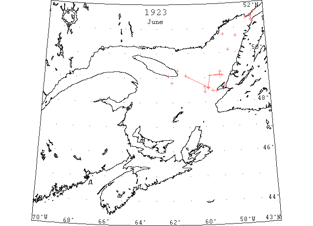
Jun 1 Heath Point: heavy open ice distant. South Point: light open ice. Belle Isle: heavy close-packed ice inshore, some bergs. (HB 1762 Jun 13 CSS)
Jun 2 CGS “Mikula” 49°14’N 59°02’W: 4 p.m., scattered ice in all directions, visibility 5 miles; 8 a.m., heavy ice extending north as far as can be seen in 48°26’N 60°00’W. (HB 1762 Jun 13 CSS)
Jun 4 Heath Point: heavy open ice distant. Point Amour: heavy close-packed ice distant. Belle Isle: (a.m.), heavy close-packed ice, distant. Belle Isle: (p.m.), heavy open ice everywhere, 16 bergs. (HB 1762 Jun 13 CSS)
Jun 4 CGS “Mikula”: off Cape St. George, scattered ice extending 10 miles from shore. (HB 1762 Jun 13 CSS)
Jun 5 Heath Point: heavy open ice distant. Point Amour: heavy close-packed ice distant. Belle Isle: heavy open ice distant. (HB 1762 Jun 13 CSS)
Jun 5 CGS “Mikula”: from 50°07’N 58°28’W, to Flat Island, open ice; passed two small bergs. From Flat Island to 50°40’N 57°56’W, scattered ice. Ice extends all up and down the Labrador coast as far as could be seen. (HB 1763 Jun 20 CSS)
Jun 6 CGS “Mikula”: at Point Amour the ice extends from shore to shore; westward the ice is very scattered and moving eastward. (HB 1763 Jun 20 CSS)
Jun 6 CGS “Mikula”: from Pinware Bay to Greenly Island, heavy close-packed ice moving east 1½ miles per hour. (HB 1763 Jun 20 CSS)
Jun 7 CGS “Mikula”: from 49°07’N 59°05’W to 49°05’N 59°40’W, heavy open ice; from this latter position heavy ice in all directions as far as can be seen. (HB 1763 Jun 20 CSS)
Jun 7 CGS “Mikula”: from a position 19 miles 298° (mag.) from Little Port Light to 49°05’N 59°40’W, heavy open ice extending east and west as far as could be seen; heavy, close packed to the north. From the last position to a point 22 miles 318° (mag.) from Cape St. George, heavy open ice; the inner edge is 18 to 25 miles off the Newfoundland shore. Port au Port Bay appeared to be full of ice. The western edge of the ice field extended from 48°36’N 59°46’W, to about 20 miles off Heath Point, on a line about northwest and southeast; thence it skirted more westerly. 48°48’N 62°02’W, heavy packed ice. (HB 1763 Jun 20 CSS)
July 2 First Westbound steamer through the strait of Belle Isle. (WBB)
Oct 2 SS “Brecon” 51°50’N 55°34’W: a berg; about 1 mile off Point Amour, a[nother] berg; and a large growler on the track about 36 miles 222° from Greenly Island. (HB 1780 Oct 17)
Oct 7 SS “Eastern Dawn” 40°46’N 65°54’W: passed a large growler about 100 feet square. (HB 1780 Oct 17)