1916 Season
Nov 30 Last eastbound steamer through the Strait of Belle Isle. (WBB)
Dec 11 Last departure of the season from Quebec. (WBB)
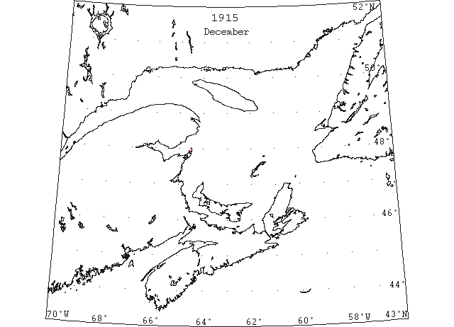
Dec 20 J.A. Ward, Lightkeeper, Miscou Point, New Brunswick: Closing date. (CIS IC0756)
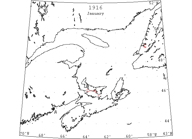
Jan 1 The Steam Navigation Company’s boats, concluded their season’s work on Saturday, and the “Empress” arrived here from Summerside yesterday. Last season she ceased running on December 21st, 1914 and the “Northumberland” made her last trip on the 22nd. The “Prince Edward Island” left Charlottetown this morning at 7 o’clock for Pictou. The “Stanley” left Summerside at 8:15 for Tormentine on the arrival of the special train which left Charlottetown at 6 o’clock. The Straits are still about as clear as summer, with practically no ice, and quick trips will therefore be made. (Pat 3 Jan 1916 p8#3)
Jan 3 The “Stanley” made the round trip to Pictou today, arriving in Summerside at 12:30 with mail, passengers and freight. (Pat 3 Jan p5#2)
Jan 4 The “Stanley” left Summerside at 8:15 am today docked in Tormentine at 9:45 left on return at 11:30 and docked in Summerside at 12:45. (Pat 4 Jan p5#2)
Jan 5 On Mon. people were able to cross from Summerside to Curling on the ice for the first time this season. (TWS, pg. 2, Col. 3)
Jan 5 There are about 5 inches of ice on the Humber Arm. The “Seal” did good work yesterday and negotiated a passage through the ice from Meadows [to Curling] in less than 2 1/2 hours. Some slob ice formed on the waters of the Humber Arm on Thur. night and by Fri. evening it had extended to Meadow’s Point. (TWS, pg. 3, Col. 4)
Jan 7 The “Stanley” did not arrive at Tormentine until 11:45 am today, having had some trouble with the ice. (Pat? 7 Jan p5#3)
Jan 10 Owing to the heavy ice the “Stanley” has been obliged to discontinue the Tormentine-Summerside route. She had considerable difficulty today and was stuck in the ice off Sea Cow Head until 2:30. It is expected that she will dock in Tormentine this evening. She will then leave for Charlottetown and leave here tomorrow morning at 7:00. (Pat 10 Jan p5#2)
Jan 10 The “Stanley” left Tormentine at 6:00 pm yesterday and docked in Charlottetown at about 11:40. She had considerable difficulty with the ice all the way, and kept going despite the thick weather. She left this afternoon at 2:30 on return to Pictou. (Pat 11 Jan p5#3)
Jan 12 The ice spanning the Humber Arm from here to Summerside appears to be quite firm now, and yesterday teams were able to drive over it. (TWS, p.3).
Jan 14 The “Stanley” left Pictou this morning at seven and docked in Charlottetown at 11:15. Owing to the mild weather and the improvement in conditions, the ice in the bay being well scattered, it was decided to transfer her back to this route. She will remain here as long as conditions warrant. (Pat 14 Jan p8#4)
Jan 18 The “Stanley” at noon today was off Point Prim moving slowly through heavy ice. (Pat 18 Jan p4#4)
Jan 19 Owing to the Humber being covered with ice the “Portia” did not come up to Curling on her last trip, but landed the mails and freight for here at Benoit’s Cove. (TWS, p.2)
Jan 22 Gloucester: The fleet of herringers at Bay of Islands that has completed loading will sail today … while no ice has been sighted as yet. It has been the mildest winter on record on the west coast and it is figured that crafts could remain at least two weeks longer without danger, should they desire, a most unusual occurrence. (HH 25/01/1916 p9#3)
Jan 26 The steamer “Wren” towed the schooner “Douglas Adams” out of Middle Arm on Fri. The “Seal” came up the Humber Arm to the standing ice on Fri. night and landed some men from Middle Arm. (TWS, pg. 2, Col. 3)
Jan 27 SS “Rio Verde” 33°34’N 70°32’W ice in the shape of a hummock 2′ high and 40′[30′ – JH] in circumference. This is the furthest south ice has been seen in years. (NYMR)
Jan 27 SS “Rio Verde” 33°34’N 70°32’W passed a hummock of ice about 2 feet high and 40’ in circumference. (HB #1380 Feb 9)
Jan 28 The “Stanley” has been making quick trips between Georgetown and Pictou these days, the run today for instance taking only three hours – summer time. The “Prince Edward Island” is also doing excellent work on the Charlottetown-Pictou route and it is the desire of all that this service be continued as long as possible. With the exception of a few days of low temperature the winter so far has been comparatively mild, and recently but little heavy ice has been met with. The new car ferry steamer has demonstrated her abilities in board ice and if she does as well in the hummock ice which is generally met with in February and March then our people will be duly grateful. (Pat 28 Jan p8#3)
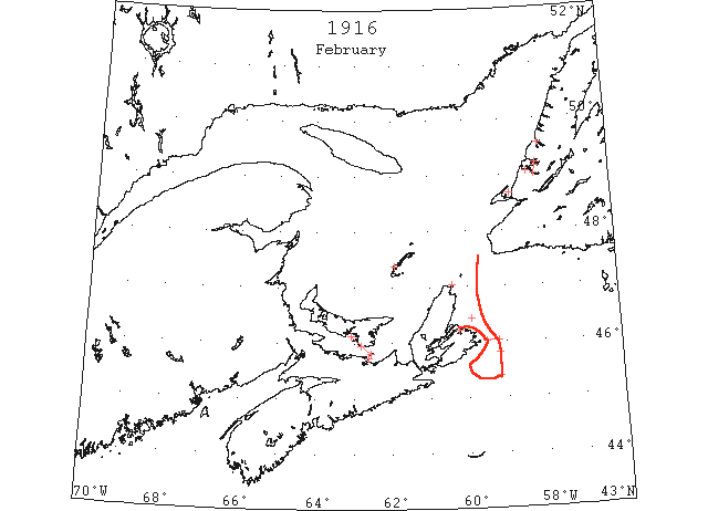
Feb 2 The SS “Sable” did not get away from Bonne Bay until Monday last week. (TWS, pg. 2, Col. 2)
Feb 2 Some slob ice which drifted out of Port au Port Bay came into Bay of Islands last week, but did no damage. (TWS, pg. 2, Col. 5)
Feb 5 The “Prince Edward Island” made an excellent trip today docking at 11:00 am. She met with a considerable amount of ice and in one place there was a large field about a foot and a half thick, through which she proceeded with very little difficulty. (Pat 5 Feb p8#3)
Feb 14 The heavy north east wind and low temperature are making trouble for the winter steamers today. At 10:55 the “Prince Edward Island” was three miles southwest of Wood Islands in heavy ice and no open water, making fairly good progress. The “Stanley” at 10:40 was 2.5 miles northeast of Coles Point, making slow progress. The ice is heavily packed and there is no open water. (Pat 14 Feb p5#3)
Feb 16 The captain of the “Kyle” on Wednesday reported ice crossing the Cabot Strait . The high winds and severe frost of the past few days have packed the Bay of Islands full of ice. On the last trip of the “Kyle”, across the Cabot Strait considerable ice was encountered both ways. (TWS, pg. 3, Col. 1)
Feb 16 Middle Arm filled with ice on Sat. and on Sun. it was strong enough for people to cross over. (TWS, pg. 3, Col. 2)
Feb 16 The ice filled into North Arm on Sat., and by now it is thought to be safe to cross over all the way from there to the Humber. (TWS, pg. 3, Col. 3)
Feb 16 The “Stanley” at 7:15 was three miles off the east end of Pictou Island, making fair progress. She was held two hours with heavy ice but got clear. (Pat 16 Feb p2#5)
Feb 17 SS “Petrolite” 45°48’N 59°12’W met heavy close packed ice which extended to the north and west as far as could be seen; steered S for 25m before losing sight of the ice. (NYMR 8 Mar)
Feb 23 There was a sign of herring in North Arm last week, but up to Sat., operations were interrupted owing to the moving ice. The ice has moved off again, and better fishing is expected at the bottom of the Arm this week. (TWS, pg. 2, Col. 4)
Feb 23 The “Florizel” was unable to reach Sydney owing to the ice blockade, and had to go to Louisburg to unload her coal cargo. (TWS, pg. 3, Col. 1)
Feb 23 Owing to Sydney being blocked with ice, the Reid boats now sail between Port aux Basques and Louisburg. (TWS, pg. 3, Col. 5)
Feb 24 SS “Sagona” from Louisburg to Port aux Basques with 2 propeller blades broken by ice. (NYMR)
Feb 24 The “Prince Edward Island” which left here yesterday morning at 9:30 did not dock in Pictou till 7:15 this morning. She found the ice unusually heavy in the bay and straits. (Pat 24 Feb p8#4)
Feb 28 Magdalen Islands – No water in sight. Money Point – Heavy close packed ice everywhere. Cape Ray – No ice. Flat Point, light, open ice distant. Belle Isle – foggy. (HH 01/03/1916 p9)
Feb 28 The “Stanley” which left Georgetown on Saturday morning, reached Pictou yesterday at 11:15 am. She had considerable difficulty with the heavy ice which was driven in the Gulf by the easterly winds. With the westerly winds the ice was loosened and steamer was enabled to reach port. (Pat 28 Feb p8#3)
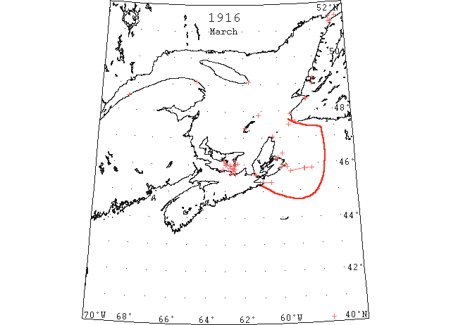
Mar 1 Traveling across the ice from St. George’s to Sandy Point is now in good condition. (TWS, pg. 3, Col. 3)
Mar 1 Ice and adverse weather interfere somewhat with fishing operations in Channel and Port aux Basques. (TWS, pg. 3, Col. 4)
Mar 1 On her last trip across the Cabot Strait the “Sagona” lost the blades of her propeller by contact with ice. She goes to St. John’s for repairs. (TWS, p.3)
Mar 1 Halifax, the Grimsby steam trawler “Andromache” came in yesterday with a cargo of eleven thousand pounds of fish. The last trip he said was very good and to use his own words, “they made a living” but the past two months have been bad. And now it’s cold and the ice is forming in the northern harbors. We had great trouble getting out of Canso which port has been headquarters. Even as far away as twenty miles out, we ran thru drift ice. Of course that was harmless but in a big storm it would be anything but harmless. (HH 01/03/1916 p9)
Mar 1 The “Stanley” docked in Georgetown at 10:30. At the same time the “Prince Edward Island” was five miles south of Point Prim doing good work in very heavy ice. There was no open water to be seen. (Pat 1 Mar p8#4)
Mar 3 SS “Missourian” 40°10’N 57°40’W passed 3 pieces of ice about 4 feet square. (HB #1389 Apr 12)
Mar 3 SS “Missourian” 40°10’N 57°40’W: passed three pieces of ice about 4 feet square. (HB 1389 Apr 12)
Mar 4 Magdalen Island – No water in sight on north side. Money Point – Heavy, close packed in shore. Cape Ray – Light, close packed everywhere. Flat Point – Ice melting fast. Point Amour – Heavy close packed everywhere. Belle Isle – Heavy close packed distant. (HH 04/03/1916 p11#2)
Mar 4 The “Prince Edward Island” had a very rough experience in the snowstorm Saturday night. The steamer had arrived off Fitzroy Rocks, about 4 miles from the Harbour entrance about noon after ploughing through heavy rafted ice off Wood Islands and has sent a message to the city that she would be in by 12:30. Then the storm broke with such fierceness that it was impossible to see the length of the ship. Anchors were dropped but in the violent gale and heavy sea they would not hold and the Captain was obliged to weigh anchor and make for open sea. Some miles out she was driven into the ice and remained until daylight yesterday morning after the storm had cleared away. She docked at 8:00. (Pat 6 Mar p8#4)
Mar 7 Cape Ray, Heath Point – Light, close packed everywhere. Magdalen Islands – Ice in sight everywhere. Money Point – Heavy close packed ice inshore. Scatarie – Light close packed ice inshore. Point Amour – Heavy close packed ice everywhere. Flat Point – Light close packed ice, stationary. (HH 07/03/1916 p9#3)
Mar 8 Large crowds took advantage of fair skating and ice boating on the Humber on Sat. (TWS, pg. 2, Col. 4)
Mar 8 Codroy- Wind W.N.W, strong breeze, ice solid to land, no water to be seen. Flower’s Cove- Strong N.W. wind, fair and cold. Straits blocked with ice. Heath Point- Cloudy, strong north, heavy open ice in shore. Magdalene Islands- Clear, strong, N.W., ice all around island. Money Point- Cloudy, strong north-west, heavy closed packed ice inshore. Cape Ray- Clear, gale, N.W., light open ice everywhere. Flat Point- Clear, strong N.W., light open ice everywhere. Flat Point- Clear, strong N.W., no ice [different time?] Point Amour- Unsettled N.W., heavy closed packed ice everywhere. (TWS, pg. 2, Col. 3)
Mar 8 There is just a sign of herring in North Arm. The drift ice has been to land several times, but the southerly and easterly winds take it off again. (TWS, pg. 3, Col. 3)
Mar 9 Heath Point – Light close packed everywhere. Magdalen Islands – Ice packed close inshore. Flat Point – Light open ice distant. Point Amour – Heavy, close packed distant. (HH 09/03/1916 p9#3)
Mar 12 Halifax: Dangerous ice fields in the track of shipping are reported tonight by the Canadian Marine department. The ice stretches from 45°50’N 58°45’W to 45°45’N 59°30’W. It is believed that the floes also extend more to the eastward. (NYMR 15 Mar)
Mar 12 SS “Statesman” 45°50’N 58°43’W encountered dangerous ice field which practically extended to the Cape Breton coast; passed through about 12 miles of brash ice to reach Louisburg. The ice extended to the eastward of the first-mentioned position as far as could be seen. (HB #1386 Mar 22)
Mar 13 Heath Point, Magdalen Islands, Money Point Heavy close packed everywhere. Flat Point – Light close packed distant. Cape Ray – Light close packed everywhere. Point Amour – Snowstorm. (HH 13/03/1916 p8#2)
Mar 13 Halifax, a dangerous field of ice in 45°50’N 58°45’W to45°45’N 59°30’W and that the field probably extended to the eastward. (HH 13/03/1916 p8#3)
Mar 14 The “Prince Edward Island” made one of the best trips this season today. She left Pictou shortly after seven and docked in Charlottetown at 10:30, this being almost summer time. There was a good deal of ice but many leads were taken advantage of. (Pat 14 Mar p8#3)
Mar 15 Owing to the ice not being solid at North Arm it is impossible to transfer the salt and barrels to Middle Arm. (TWS, pg. 2, Col. 1)
Mar 15 Ice continued to interfere with cod fishing operations at Channel. That part of the coast was packed with heavy ice most of the past week (TWS, pg. 2, Col. 5)
Mar 15 Codroy- Wind W., moderate breeze, ice closely packed to land. Money Point and Point Amour- Heavy closed packed ice everywhere. Flat Point- Light close packed ice everywhere. Magdalen Islands- Some open water north side. Heath Point- Snowing, gale S.E., heavy close packed ice inshore. (TWS, pg. 2, Col. 5)
Mar 15 Large crowds of people take advantage of the skating on the ice of the Humber these days. (TWS, p 3, Col. 2)
Mar 15 Heath Point – Light close packed everywhere. Magdalen Islands, Money Point -Heavy close packed everywhere. Flat Point – Light, open everywhere, stationary. Cape Ray – Heavy close packed distant. Scatarie – Light, open inshore. Father Point to Fame Point – Heavy open ice everywhere. (HH 17/03/1916 p9#2)
Mar 16 The “Stanley” at 10:30 was five miles east of Cape Bear in heavy ice. The “Prince Edward Island” left Pictou at 10:00. (Pat 16 Mar p5#4)
Mar 16 The “Prince Edward Island” left Pictou yesterday at 10 o’clock and docked in Charlottetown at four pm. Captain Murchison is to be commended on his fine seamanship in making port under such unfavourable conditions. He had to encounter heavy ice and a snow storm all the way. He came down to the west end of Pictou Island then cut across thru the ice to the Island shore, where he was fortunate in getting a glimpse of Point Prim. He reached the Point about 2:45 and then came right along to Charlottetown. T he steamer is certainly doing splendid work and her arrival here yesterday was an agreeable surprise. (Pat 17 Mar p8#4)
Mar 17 Heath Point – Light close packed everywhere. Magdalen Islands, Money Point -Heavy close packed everywhere. Flat Point – Light, open everywhere, stationary. Cape Ray – Heavy close packed distant. Scatarie – Light, open inshore. Father Point to Fame Point – Heavy open ice everywhere. (HH 17/03/1916 p9#2)
Mar 17 & 18 The “Stanley” docked in Pictou at 5 PM yesterday and left this morning for Georgetown at six, arriving there at nine, a very quick trip for this time of year. (Pat 18 Mar p5#2)
Mar 18 The “Prince Edward Island” docked at 2:45 pm. The captain reports very heavy ice on the Nova Scotia shore but he took advantage of leads near Amet Island. The schooner “Annie M. Parker” was carried 15 miles down the straits since yesterday and today was 4 miles north of the west end of Pictou Island. (Pat 18 Mar p5#2)
Mar 21 U.S. Coast Guard Cutter “Ossipee” rendering ice breaking assistance in Fox island Thoroughfare, Maine; 44°07.5’N 68°53.5’W; also rendering ice breaking assistance at Channel Rock Beacon, Maine; 44°08’N 68°49’W (U.S. National Archives and Records Administration, Archives I, Washington, D.C., Record Group 26, Part II, Entry 166 (NC-31), Copies of Reports of Assistance Rendered, 1903-1914) [Note, this file contains numerous other reports of icebreaking activities of U.S. Coast Guard Cutters, but time did not permit these to be collected.]
Mar 22 The Gulf fleet are reported jammed in the ice off Bird Rocks (TWS, pg. 2, Col. 2)
Mar 22 The “Florizel” was unable to reach Sydney owing to the ice blockade, and had to go to Louisburg for her coal cargo. (TWS, p.3)
Mar 24 The “Stanley” is caught in heavy ice half way between Cape Bear and Pictou Island. The “Prince Edward Island” at 1:45 was proceeding towards the East end of Pictou Island. She had to abandon the west end route on account of heavy ice. She is now coming to Charlottetown. (Pat 24 Mar p8#4)
Mar 24 The “Stanley” at 10 o’clock was 5 miles southwest of Cape Bear in a thick snow storm and very heavy ice. (Pat 24 Mar p8#4)
Mar 25 Heath Point – Light close packed, everywhere. Magdalen Islands, Scatarie, Money Point, Cape Ray, Flat Point – Heavy snow. (HH 25/03/1916 p13#3)
Mar 25 At noon the “Prince Edward Island” was three miles south of Point Prim, making good progress. The Captain hopes to dock this evening. The “Stanley” was in the same position as previously reported. (Pat 25 Mar p8#4)
Mar 25 The “Prince Edward Island” docked in Charlottetown about five o’clock on Saturday afternoon. She met with ice all the way over and the recent snow storm added to the difficulties owing to the formation of lully (lolly?). She was delayed for a time working into the harbour for that reason. She left yesterday morning at 7:00 on return to Pictou, after taking in a quantity of coal. She is meeting with considerable difficulty today and at noon was reported two miles from the Stanley, 1.5 miles off the east end of Pictou Island. Both steamers are stuck and are not attempting to break through the ice until conditions improve. Captain Murchison reports the ice being blocked solid between Pictou Island and Merigomish. At the time of writing it was blowing freshly from the North-east, but once the wind goes down the ice will loosen up and make conditions more favourable. (Pat 27 Mar p8#3)
Mar 28 The steamer “Stanley,” from Georgetown Thursday, and the “P E Island,” from Charlottetown Sunday, were both still in the ice off the eastern end of Pictou Island Tuesday night with no chance of moving until the wind shifted. (HH 31/03/1916 p7#4)
Mar 28 Owing to the steamers being blocked off Pictou Island the mails were sent last night to Cape Traverse where they will be taken across today. Four boats left this morning for Cape Tormentine. (Pat 28 Mar p8#3)
Mar 29 With a little frost it would be fairly good skating on the Humber. (TWS, pg. 3, Col. 2)
Mar 29 The offshore winds of late have taken the ice out of Bay of Islands. In the Eastern Passage it has gone from Stewarts Point across little Brook, while in the Western Passage it is gone from Woods Island Harbor to Blomidon. (TWS, pg. 3, Col. 3)
Mar 31 Scatarie – Heavy, close packed ice everywhere. Point Tupper, Mulgrave – Heavy, open everywhere. Grindstone – Dense fog. Money Point – Heavy, close, packed inshore. Flat Point – Heavy, close packed ice everywhere, stationary. (HH 31/03/1916 p7#4)
Apr 1 The “PEI” docked at Pictou at 11:30 am. The “Stanley” docked in Pictou at 7:15 this morning. She leaves for Georgetown tomorrow morning and as far as known at present, the Car ferry will leave on Monday morning for Charlottetown. (Pat 1 Apr p8#5)
Apr 2 There is still a vast quantity of heavy ice around the coast and it needs only a north easter to block up the steamers again. With the continuance of south or south westerly winds conditions will be so improved that the steamers will find no difficulty in making regular crossings. (Pat 3 Apr p2#3)
Apr 4 The Canadian Signal Service: Father Point, light open ice. (NYMR 12 Apr p. 10, col. 2)
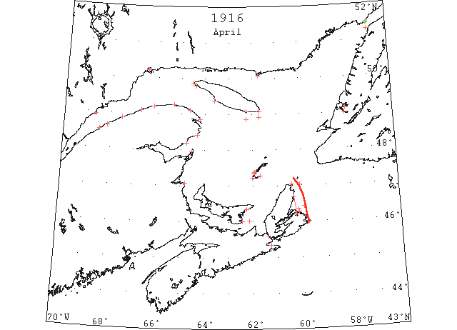
Apr 4 Father Point: light open ice. Little Métis: light close packed ice inshore. Matane: light close packed ice inshore. Cape Chatte: light close packed ice inshore. Martin River: heavy close packed ice. Cape Magdalen: heavy close packed ice inshore. Fame Point: heavy close packed ice everywhere. Cap des Rosiers: heavy open ice. Ellis Bay: broken ice outside. South Point: heavy open ice everywhere. Heath Point: heavy open ice inshore. Seven Islands: bay fast to outer islands. Scatari: heavy close packed ice everywhere. Grindstone: heavy close packed ice everywhere. Cape Bear: heavy close packed ice everywhere. Money Point: heavy close packed ice. Flat Point: heavy close packed ice distant. Point Amour: heavy open ice. Belle Isle: heavy open ice stationary, 30 bergs. (HB 1389 Apr 12 CSS)
Apr 5 The rain on Sun. took away much of the snow and somewhat softened up the ice, but the frost of Mon. and yesterday hardened it again and traveling over the Humber Arm is now fairly good. (TWS, pg. 2, Col. 5)
Apr 5 Heath Point – Heavy close, packed everywhere. Scatarie – Heavy, close, packed inshore. Point Tupper – Light open everywhere. Magdalen Islands, Flat Point – Heavy, close packed everywhere. Money Point –Heavy, close, packed, inshore. (HH 05/04/1916 p9#2)
Apr 5 Amherst Harbor, no change with ice conditions, solid mass in gulf. Queensport, no ice in bay. (HH 06/04/1916 p9#2)
Apr 5 Little Métis: light close packed ice inshore. Cape Chatte: light close packed ice inshore. Martin River: heavy close packed ice. Cape Magdalen: heavy open ice moving east. Cape Despair: very little ice. Fame Point: heavy close packed ice everywhere. Cap des Rosiers: heavy open ice. Ellis Bay: bay cleared inside wharf. Southwest Point: light open ice inshore moving south. South Point: heavy open ice everywhere. Heath Point: heavy open ice inshore. Seven Islands: bay fast to outer islands. Scatari: heavy close packed ice everywhere. Grindstone: heavy close packed ice everywhere. Point Amour: heavy close packed ice moving west. Belle Isle: heavy close packed ice everywhere, 40 bergs. (HB 1389 Apr 12 CSS)
Apr 6 Scatari: light open ice everywhere. (NYMR)
Apr 6 The Canadian Signal Service: Martin River, heavy close packed ice; Cape Magdalene, light open inshore; South Point, light close pack inshore; Grindstone, heavy, close packed ice everywhere; Flat Point, heavy close packed ice, moving west; Heath Point, heavy open ice distant. (NYMR 12 Apr p. 10, col. 2)
Apr 6 Heath Point – Heavy open, ice inshore. Magdalen Islands. Scatarie, Money Point –Heavy, close, packed everywhere. Cape Ray –No ice. Flat Point – Heavy, close packed distant. (HH 06/04/1916 p9#3)
Apr 6 Martin River: heavy close packed ice. Cape Magdalen: light open ice inshore. Cape Despair: heavy close packed ice everywhere. Cap des Rosiers: heavy open ice. South Point: light close packed ice inshore. Heath Point: heavy open ice distant. Scatari: light open ice everywhere. Grindstone: heavy close packed ice everywhere. Point Tupper: light open ice everywhere. Cape Bear: heavy close packed ice distant. Flat Point: heavy close packed ice 10 miles moving SE. (HB 1389 Apr 12 CSS)
Apr 7 Martin River: heavy close packed ice. Cape Magdalen: light open ice everywhere. Cap des Rosiers: heavy open ice. Ellis Bay: very little ice outside. Heath Point: heavy open ice inshore. Scatari: heavy close packed ice inshore moving SE. Grindstone: heavy close packed ice everywhere. Point Tupper: light open ice everywhere. Cape Bear: heavy close packed ice everywhere. Money Point: heavy close packed ice distant. Flat Point: heavy close packed ice inshore. Point Amour: heavy close packed ice stationary. Belle Isle: heavy open ice moving SW, 2 bergs. (HB 1389 Apr 12 CSS)
Apr 8 As telegraphed to the Board of Trade, April 8. Heath Point – Heavy open, inshore. Scatarie – Heavy, close, packed inshore. Point Tupper – Light, open everywhere. Money Point, Flat Point, Point Amour– Heavy, close packed everywhere. (HH12/04/1916 p9#3)
Apr 8 Cape Magdalen: light open ice inshore. Cap des Rosiers: heavy open ice. Heath Point: heavy open ice inshore. Seven Islands: ice breaking. Scatari: heavy close packed ice inshore. Grindstone: heavy close packed ice everywhere. Point Tupper: light open ice everywhere. Money Point: heavy close packed ice everywhere moving SE. Flat Point: heavy close packed ice everywhere stationary. Point Amour: heavy close packed ice moving west. (HB 1389 Apr 12 CSS)
Apr 9 J.A. Ward, Lightkeeper, Miscou Point, New Brunswick: Opening date. (CIS IC0756)
Apr 10 Point Tupper: light open ice everywhere. Heath Point: heavy close packed ice inshore. Scatari: light open ice inshore moving east. Seven Islands: ice breaking, water 2 miles off wharf. Cape Bear: heavy close packed ice distant. Money Point: heavy close packed ice distant. Flat Point: heavy close packed ice distant moving west. (HB 1390 Apr 19 CSS)
Apr 11 L’Islet: very little ice. Cap des Rosiers: heavy open ice everywhere. Cape Despair: very little ice. Point Maquereau: light close packed ice everywhere moving east. Bersimis: very little ice along north shore. Point Tupper: light open ice everywhere. Heath Point: heavy open ice distant. West Point: broken ice about 2 miles wide along shore in North Channel. Grindstone: light close packed ice everywhere. Seven Islands: harbour clear of ice. Cape Bear: heavy close packed ice distant. Money Point: light close packed ice inshore. Flat Point: heavy close packed ice everywhere moving southeast. Point Amour: heavy close packed ice stationary. Belle Isle: heavy close packed ice everywhere, 12 bergs. (HB 1390 Apr 19 CSS)
Apr 12 The ice in the Bay of Islands broke up on Sunday in to Brown’s Point, and the heavy wind of that night took it out. Several teams fell through the ice in the Humber Arm on Sat. (TWS, pg. 3, Col. 2)
Apr 12 South Point: heavy open ice inshore. Point Tupper: light open ice everywhere. Heath Point: heavy open ice inshore. Grindstone: open water north. Seven Islands: ice clear to wharf. Cape Bear: heavy close packed ice distant. Money Point: light close packed ice inshore. Flat Point: heavy close packed ice distant. Belle Isle: heavy open ice stationary, 7 bergs. Point Amour: heavy close packed ice stationary. (HB 1390 Apr 19 CSS)
Apr 13 Cape Rosier – Heavy open ice everywhere. Point Maquereau – Light close packed ice everywhere. West Point, Anticosti – Broken ice in North Channel. Heath Point – Heavy, open ice distant. Magdalen Islands, Flat Point, Belle Isle, Point Amour – Heavy, close packed everywhere. Money Point – Light close packed inshore. Cape Ray, Scatarie – No ice. Amherst Harbor – No change with ice conditions, islands surrounded everywhere. (HH 13/04/1916 p9#4)
Apr 13 Bersimis: very little ice along coast. Natashquan: harbour still blocked. South Point: heavy close packed ice everywhere. Point Tupper: light open ice everywhere. Heath Point: heavy close packed ice everywhere. Scatari: light open ice inshore. Grindstone: heavy close packed ice everywhere moving east. Seven Islands: harbour clear of ice. Cape Bear: ice moving east. Flat Point: heavy close packed ice distant. Belle Isle: heavy open ice everywhere, 3 bergs. Point Amour: heavy close packed ice distant. (HB 1390 Apr 19 CSS)
Apr 14 Point Tupper: light open ice everywhere. (HB 1390 Apr 19 CSS)
Apr 15 Queensport, some scattered ice in bay. Amherst Harbor, MI, Ice moved away from around the island. According wind stationary [sic]. Ice still on Amherst Harbor side from Sandy Hook to Harbor Basque. (HH 17/04/1916 p11#3)
Apr 15 Cape Despair: very little ice. Point Maquereau: heavy open ice everywhere. Heath Point: heavy open ice. Grindstone: heavy close packed ice everywhere. Cape Bear: heavy close packed ice. Money Point: heavy close packed ice inshore. Flat Point: heavy close packed ice distant moving south. Belle Isle: 3 bergs. Point Amour: heavy close packed ice everywhere moving west. (HB 1390 Apr 19 CSS)
Apr 17 West Point: very little ice. South Point: heavy open ice inshore. Heath Point: heavy close packed ice everywhere. Grindstone: heavy close packed ice everywhere. Cape Bear: heavy close packed ice distant. Money Point: heavy close packed ice everywhere. Flat Point: heavy close packed ice everywhere. Point Amour: heavy close packed ice everywhere. (HB 1391 Apr 26 CSS)
Apr 18 South Point: heavy open ice inshore. Heath Point: heavy close packed ice everywhere. Scatari: heavy close packed ice everywhere. Seven Islands: harbour clear. Money Point: heavy close packed ice inshore. Flat Point: heavy close packed ice inshore, stationary, extending northward, heavy open ice eastward. Point Amour: heavy close packed ice distant moving west. (HB 1391 Apr 26 CSS)
Apr 19 The ice in the Humber Arm is gone out from Frenchman’s Cove. In Middle Arm it is gone to Cox’s Cove, and in North Arm there remains just a little ice in the Bottom. The Humber River is cutting down rapidly and has almost reached Crow Head. With another 8 or 10 day of spring weather navigation in the Humber will be opened. (TWS, pg. 3, Col. 3)
Apr 19 Heath Point: heavy open ice inshore. Grindstone: no ice north, heavy close packed ice on all other points. Cape Bear: heavy close packed ice distant. Scatari: heavy close packed ice everywhere. Seven Islands: harbour clear. Money Point: light close packed ice everywhere. Flat Point: heavy close packed ice inshore, stationary, Sydney northward to Ingonish light close packed ice. Point Amour: heavy close packed ice distant moving west. (HB 1391 Apr 26 CSS)
Apr 20 South Point, Belle Isle – Heavy, close packed everywhere. Heath Point, Scatarie – heavy close packed everywhere. Money Point, Flat Point – Heavy close packed inshore. Point Amour – Heavy, close packed distant. Magdalen Islands – Some open water in sight; north of Island. (HH 20/04/1916 p9#3)
Apr 20 Money Point: light close packed ice inshore. Flat Point: heavy open ice everywhere. Point Amour: heavy close packed ice everywhere moving west. (HB 1391 Apr 26 CSS)
Apr 21 Heath Point: heavy open ice distant. Point Tupper: Strait full of ice. Money Point: light close packed ice inshore. Flat Point: heavy open ice everywhere, stationary. Point Amour: heavy close packed ice everywhere moving west. (HB 1391 Apr 26 CSS)
Apr 22 Heath Point, heavy open ice distant. Cape Bear, heavy close packed ice distant. Money Point, light close packed ice everywhere. Flat Point, heavy close packed ice everywhere stationary. Point Amour, 1 berg. (HB #1392 May 3)
Apr 22 Amherst Harbor, MI, Grindstone – No ice. Grand Entry, scattered ice. Etang du Nord blocked with ice. (HH 24/04/1916 p7#4)
Apr 24 Point Escuminac, heavy open ice everywhere. South Point, heavy open ice inshore. Heath Point, heavy open ice everywhere. Scatari, light close packed ice everywhere, no ice outside headland. Grindstone, heavy open ice everywhere. Cape Bear, heavy close packed ice everywhere. Money Point, light close packed ice everywhere. Flat Point, heavy close packed ice everywhere stationary. Point Amour, heavy close packed ice everywhere; 7 bergs. (HB #1392 May 3)
Apr 24 Anticosti, South Point – Heavy open ice inshore. Heath Point, Magdalen Islands – Heavy open ice everywhere. Cape Ray, no ice. Money Point, Scatarie – Light, close packed everywhere. Flat Point – Heavy close packed everywhere, stationary: sailing steamer eastward. Point Amour, Belle Isle – Heavy open ice everywhere and bergs. Quebec to Montreal River clear since Saturday last. (HH 26/04/1916 p9#3)
Apr 26 Bay of Islands is now free of ice, and even the drift ice is a long way off shore. (TWS, p.3)
Apr 26 Point Escuminac, heavy open ice everywhere. Southwest Point, heavy open ice inshore. Heath Point, light close packed ice inshore. Scatari, light open ice inshore. Point Tupper, heavy open ice everywhere. Grindstone, heavy open ice everywhere. Cape Bear, heavy close packed ice everywhere. Money Point, light close packed ice inshore. Flat Point, heavy close packed ice everywhere stationary. Point Amour, heavy close packed ice everywhere; 3 bergs. (HB #1392 May 3)
Apr 26 Queensport, no nets set on account of scattered ice. Souris, North and south side packed with ice, no bait. Amherst Harbor, Island surrounded with ice, easterly wind prevailing, no bait report. (HH 27/04/1916 p9#3)
Apr 27 Point Escuminac, heavy open ice everywhere. South Point, light close packed ice distant. Flat Point, heavy close packed ice everywhere. Point Amour, heavy close packed ice stationary. (HB #1392 May 3)
Apr 28 Point Escuminac, heavy open ice everywhere. Grindstone, light close packed ice everywhere. Cape Bear, heavy close packed ice everywhere. Money Point, light open ice inshore. Flat Point, light close packed ice inshore northward, no ice westward. Point Amour, heavy close packed ice moving. (HB #1392 May 3)
Apr 29 Bay of Islands is now free of ice, and even the drift ice is a long way off shore. (TWS, pg. 2, Col. 2)
Apr 29 Ice is fairly good [in Middle Arm] and herring was hauled over all Fri. The ice in Middle Arm has gone from Woman Cove Head to Box Barachoix. (TWS, pg. 3, Col. 1)
Apr 29 Navigation in the Humber Arm opened on Monday (TWS, pg. 3, Col. 3)
Apr 29 Grindstone: heavy open ice everywhere. Cape Bear: heavy close packed ice everywhere. Money Point: light open ice distant. Point Amour: heavy close packed ice everywhere moving west, 3 bergs. (HB 1393 May 10 CSS)
Apr 30 Point Amour: light open ice everywhere, 2 bergs. (HB 1393 May 10 CSS)
May 1 First arrival of season at Quebec. (WBB)
May 1 Grindstone: heavy open ice south and west, no ice north and east. Cape Bear: heavy close packed ice everywhere. Flat Point: heavy close packed ice inshore. Point Amour: heavy close packed ice everywhere. (HB 1393 May 10 CSS)
May 2 Grindstone: heavy open ice south and west, no ice north and east. Flat Point: heavy close packed ice inshore; heavy open ice everywhere moving southeast. Point Amour: heavy open ice everywhere moving west. (HB 1393 May 10 CSS)
May 3 Amherst Harbor, ice moving out of Pleasant Bay, none in sight to the southward. (HH 04/05/1916 p9#4)
May 3 Point Tupper: heavy close packed ice everywhere. Scatari: light open ice inshore. Point Amour: heavy close packed ice distant. 1 berg. (HB 1393 May 10 CSS)
May 4 Souris, ice still north on the side and Eastport, south side, it is clear. Amherst Harbor, Pleasant Bay clear of ice, also Grand Entry and Etang du Nord. Ice in sight to the southward. Queensport, no ice in bay. (HH 05/05/1916 p7#2)
May 4 Grindstone: light open ice distant southwest. Flat Point: heavy close packed ice inshore moving southeast. Point Tupper: heavy close packed ice everywhere. (HB 1393 May 10 CSS)
May 5 Amherst Harbor, ice reported in sight except to the westward and southward. (HH 06/05/1916 p15#3)
May 5 … Field ice from Gulf of St. Lawrence was reported by S.S. “Virginian” on May 5th in latitude 43°15’N., longitude 62°29’W., which information was [re]broadcasted for several days [by the U.S. Coast Guard Cutter “Tampa”]. (from a May 22, 1916 report of Captain F.A. Lewis of the U.S. Revenue Cutter “Seneca” entitled, “Report of Ice Patrol cruise, May 1st to 21st, 1916.” addressed to Captain Commandant Coast Guard, Washington, D.C., U.S. National Archives and Records Administration, Archives I, Washington, D.C., Record Group 37, Hydrographic Office, General Correspondence 1907-1924, Box 149, [Ice] Patrol Ship Reports, file 122906/2995psr, second item, p. 1 of 2 pp.)
May 5 Grindstone: light open ice distant. Flat Point: heavy open ice distant moving southeast. Scatari: light open ice distant. (HB 1393 May 10 CSS)
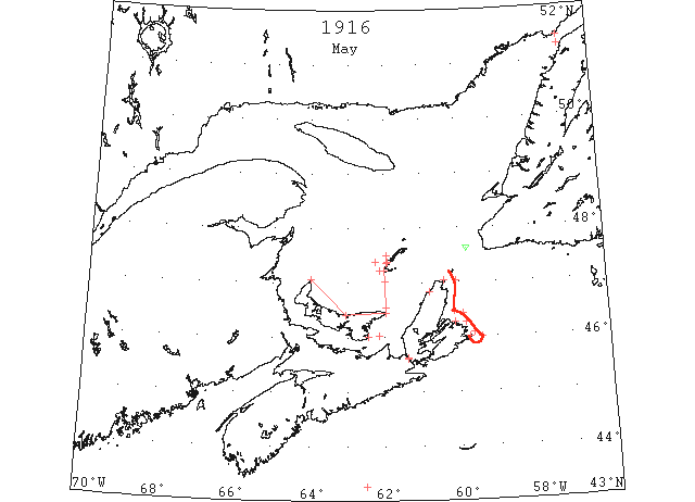
May 6 Grindstone, light open ice distant south and west. Scatarie, light open ice everywhere. Point Tupper, heavy close packed ice in strait: Magdalen Islands, light open ice distant: Flat Point, heavy close packed ice distant, moving SE; Point Amour, light open ice everywhere moving W; four icebergs. Belle Isle, heavy open ice everywhere, 12 icebergs. (HH 16/05/1916 p9#4)
May 6 Grindstone: light open ice distant south and west. Flat Point: heavy close packed ice distant moving southeast. Point Tupper: heavy close packed ice in Strait. Scatari: light open ice everywhere. Magdalen Islands: light open ice distant. (HB 1393 May 10 CSS)
May 7 Point Amour: light open ice everywhere. Belle Isle: heavy open ice everywhere, eight bergs. (HB 1394 May 17 CSS)
May 8 Amherst Harbor, ice ten miles off Point Basse, Etang Du Nord, ice in sight; Amherst Harbor, loose ice in sight southward. (HH 09/05/1916 p9#3)
May 8 Grindstone: light open ice inshore north. Cape Bear: heavy open ice everywhere. Money Point: light open ice inshore. Scatari: light open ice inshore. Flat Point: heavy close packed ice distant eastward. Belle Isle: heavy open ice everywhere. (HB 1394 May 17 CSS)
May 9 Scatarie, light open ice inshore; Money Point, light open ice distant; Flat Point, heavy open ice distant. (HH 24/05/1916 p9#2)
May 9 Money Point: light open ice distant. Scatari: light open ice inshore. Flat Point: heavy open ice distant. (HB 1394 May 17 CSS)
May 11 Amherst Harbor, plenty of herring reported this morning everywhere, but at Etang du Nord, which is blocked with ice. Ice in sight south to northwest. (HH 12/05/1916 p9#3)
May 12 Grindstone: ice in sight westward. Cape Bear: light open ice distant. Money Point: light open ice everywhere. Point Amour: light open ice distant. Belle Isle: heavy open ice everywhere. (HB 1394 May 17 CSS)
May 13 Souris, heavy ice north side and East Point. Two vessels arrived yesterday. No ice to be seen off Souris and Georgetown. Amherst Harbor, Etang du Nord very rough no herring and no ice in sight. Queensport, Herring scarce, no ice. (HH 15/05/1916 p9#3)
May 13 Grindstone: ice reported in sight south and west. Money Point: light open ice inshore. Flat Point: heavy open ice distant northward. Point Amour: two bergs. (HB 1395 May 24 CSS)
May 14 Point Amour: few bergs. (HB 1395 May 24 CSS)
May 15 Steamer “Empress,” which left P E I for Halifax, was forced to return owing to ice conditions. (HH 15/05/1916 p9#2)
May 15 Scatari: light close packed ice inshore. Money Point: light open ice inshore moving southeast. Flat Point: heavy open ice distant moving south. (HB 1395 May 24 CSS)
May 15[?]Grindstone, May 8 [18?], light open ice in shore north; Cape Bear – May 8[?], heavy open ice everywhere; Money Point, May 8[?], light open ice inshore; Scatarie, May 8[?], light open ice inshore; Flat Point, May 8[?], heavy close packed ice distant, southward; Point Amour, May 7[?], light open ice everywhere; Belle Isle, heavy open ice everywhere, eight bergs; May 8[?], heavy open ice everywhere. (HH 18/05/1916 p11#3)
May 17 The “Sagona” returned from north yesterday. She succeeded in reaching Forteau and encountered no ice during the trip. (TWS, pg. 2 Col. 3)
May 17 … On May 17th Cape Race reported that there were several bergs in Cabot Straits, latitude 47°37’N., longitude 59°47’W (from a May 22, 1916 report of Captain F.A. Lewis of the U.S. Revenue Cutter “Seneca” entitled, “Report of Ice Patrol cruise, May 1st to 21st, 1916.” addressed to Captain Commandant Coast Guard, Washington, D.C., U.S. National Archives and Records Administration, Archives I, Washington, D.C., Record Group 37, Hydrographic Office, General Correspondence 1907-1924, Box 149, [Ice] Patrol Ship Reports, file 122906/2995psr, second item, p. 1 of 2 pp.)
May 17 Money Point: light open ice inshore. Flat Point: heavy open ice inshore. (HB 1395 May 24 CSS)
May 18 Scatari: heavy open ice inshore. Money Point: light open ice distant. Flat Point: heavy open ice breaking up. (HB 1395 May 24 CSS)
May 19 Money Point: light open ice distant. (HB 1395 May 24 CSS)
May 20 The ice clings tenaciously to the waters at the north side of Prince Edward Island and presents an almost unbroken line from North Cape to East Point. A long as the wind continues from the northern quarter no change in the present conditions may be expected. This drift ice sometimes disappears completely from sight for a part of a day and returns. It is said to extend solidly as far as the Magdalens. (HH 20/05/1916 p16#4)
May 23 Scatari, scattered ice NE. (HB #1396 May 31)
May 25 Point Amour, light open ice distant. (HB #1396 May 31)
May 31 Point Amour, scattered ice everywhere. (HB #1397 Jun 7)
Jun 9 First Westbound steamer through the strait of Belle Isle. (WBB)