1912 Season
Nov 22 Last eastbound steamer through the Strait of Belle Isle. (WBB)
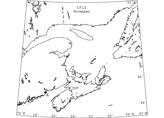
Nov 30 Cape Ray, ice making fast. North Shore, light sheet ice everywhere. (HB #1162 Dec 6, 1911)
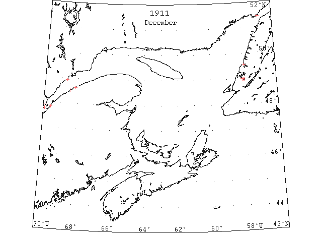
Dec 1 L’Islet, light open ice. (HB #1162 Dec 6, 1911)
Dec 4 L’Islet: light scattered ice. Cape Salmon: light open ice distant. Rivière du Loup: light open ice inshore. Belle Isle: an iceberg. (HB 1163 Dec 13 CSS)
Dec 5 Belle Isle: a berg. Father Point: light open ice inshore, moving east. (HB 1163 Dec 13 CSS)
Dec 6 L’Islet: light scattered ice. Cape Salmon: light open ice. (HB 1163 Dec 13 CSS)
Dec 8 Last departure of the season from Quebec. (WBB)
Dec 8 Cape Salmon: light open ice inshore. Belle Isle: a berg. (HB 1163 Dec 13 CSS)
Dec 9 Point Amour: light open ice everywhere. Belle Isle: light open ice and an iceberg. (HB 1164 Dec 20 CSS)
Dec 10 Cape Salmon: light open ice distant. (HB 1164 Dec 20 CSS)
Dec 12 Crane Island: very little ice. (HB 1164 Dec 20 CSS)
Dec 13 Point Amour: light open ice. Belle Isle: a berg. (HB 1164 Dec 20 CSS)
Dec 14 Belle Isle: a berg. (HB 1164 Dec 20 CSS)
Dec 15 Point Amour: light open ice. Belle Isle: light open ice and a berg. (HB 1164 Dec 20 CSS)
Dec 16 Crane Island: light scattered ice. (HB 1164 Dec 20 CSS)
Dec 17 Point Amour: Strait full of ice. Belle Isle: light close-packed ice distant. (HB 1165 Dec 27 CSS)
Dec 18 Crane Island: very little ice. L’Islet: very little ice. Point Amour: Strait full of light open ice. Belle Isle: light close-packed ice inshore and three bergs. (HB 1165 Dec 27 CSS)
Dec 19 Crane Island: very little ice. L’Islet: light scattered ice. Little Métis: ice making fast. Bersimis: thin sheet ice everywhere. Point Amour: Strait full of medium slob ice moving west. Belle Isle: light close-packed ice everywhere, and two bergs. (HB 1165 Dec 27 CSS)
Dec 20 Crane Island: light open ice. L’Islet: light scattered ice. Cape Salmon: light close-packed ice distant. Point Amour: Strait full of medium slob ice moving southwest. Belle Isle: light close-packed ice everywhere, and two bergs. (HB 1165 Dec 27 CSS)
Dec 21 Crane Island: light open ice. L’Islet: light open ice. Cape Salmon: light open ice. Point Amour: light open ice everywhere stationary. Belle Isle: light close-packed ice everywhere, and two bergs. (HB 1165 Dec 27 CSS)
Dec 22 Crane Island: light open ice. L’Islet: light open ice. Cape Salmon: light open ice everywhere. Point Amour: light open ice everywhere stationary. Belle Isle: light close-packed ice everywhere, and two bergs. (HB 1165 Dec 27 CSS)
Dec 23 On Tuesday the ice in Humber Arm extended about three miles outside Meadows Point. (TWS, p.5).
Dec 23 The hard frost of Saturday, Sunday, and Monday made ice rapidly in Humber Arm. Five vessels got caught at meadows Point but the “Fiona” went and cut them clear. (TWS, p.5).
Dec 23 The “Fiona” took the schooner “H.M. Stanley” out through the ice from Summerside Wednesday morning. (TWS p.5).
Dec 23 While the SS “Seal” was at Bonne Bay last week she steamed up through several miles of ice and released a schooner that had been caught in the floe. Though the ice was eight inches thick the ship steamed through it with no difficulty. (TWS, p.5)
Dec 23 Point Amour, light open nice everywhere, stationary. (HB #1166 Jan 3)
Dec 29 The SS “Home” experienced some difficulty negotiating a passage through the ice up the Humber Tuesday afternoon. (TWS, p. 3).
Dec 29 The SS “Seal” demonstrated her abilities as an ice breaker Sunday morning when she steamed up the Humber and berthed at Bagg Bros. wharf without difficulty. (TWS, p.3).
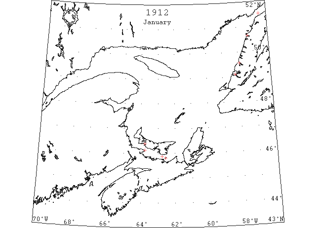
Jan 1 According to a message received yesterday, the Straits of Belle Isle are now packed with Arctic ice, which extends on the Newfoundland side as far as Port Saunders, which port the steamer “Home” was unable to enter. Last year and the pear previous, the “Home” reached Battle Harbor on her final trip, which shows that the ice is almost a month earlier coming south this season. The straits liviers, as well as those of Labrador, are now practically cut off from civilization for the next four months, except for the occasional mails, by dog and komatik, which will reach them during the winter. (HH 02/01/1912 p5#4)
Jan 5 The “Minto” is making her usual round trip between Summerside and Tormentine today. She will leave for Summerside tomorrow direst of Pictou and henceforth she will return between Charlottetown and Pictou in conjunction with the “Earl Grey” as long as ice and weather continue to permit. (Pat 5 Jan p5#4)
Jan 8 The “Minto” encountered heavy ice during the last few trips she had on the Summerside Tormentine route and met with a good deal of ice in the straits yesterday. (Pat 8 Jan p5#4)
Jan 10 The “Minto” left Pictou today, but when she got as far as Wood Islands, Captain Murchison reported the ice so heavy that he was unable to make Charlottetown. He therefore decided to go to Georgetown. (Pat 10 Jan p1#7)
Jan 16 Ships entering and leaving the ports of Pictou and Georgetown. (Pat 16 Jan p1#4)
Jan 31 The Gloucester schooner “Bohemia” is frozen in at Bonne Bay. She is the only one of the fleet that did not get clear. (TWS, p.2)
Jan 31 At 10:30 am the “Earl Grey” was three miles from the east light of Pictou Island, moving slowly through the heavy ice. The “Minto” at the same time was two miles for the east end of Pictou Island and also making fair progress. They are both expected to dock today. (Pat 31 Jan p8#3)
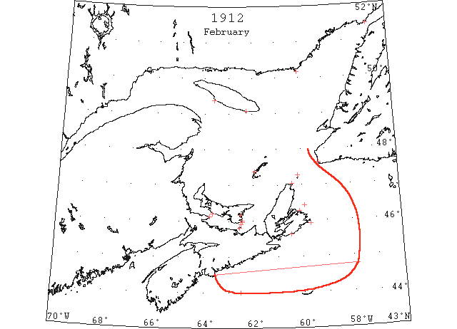
Feb 7 SS “Indramayo” 44°N 62°30’W passed numerous detached pieces of ice about 12 to 18 inches high. Some were 1000 yards long; other pieces from 200 to 300 feet long; apparently ice from some shore. (HB #1175 Mar 6)
Feb 11 Vineyard and Nantucket Sounds. SS “City of Macon”: encountered heavy ice off Nobska Point, and continued passing through the ice until off the gas buoy at Pollock Rip. Nantucket Sound is filled with ice, and sailing vessels should not attempt to go through it under the present conditions. The ice is from 4 to 5 inches in thickness. (HB 1173 Feb 21)
Feb 11 Vineyard and Nantucket Sounds. SS “H.F. Dimock”: the ice is very heavy on the shoals, and sailing vessels should not attempt to go over the shoals under the present conditions. (HB 1173 Feb 21)
Feb 12 Vineyard and Nantucket Sounds. SS “Everett”: heavy ice 6 inches thick from Cross Rip Lightship to Great Round Lightship. No clear water could be seen to the northward, and the northerly winds were packing the ice against the shore of Nantucket Island. (HB 1173 Feb 21)
Feb 12 As the result of the severe weather of the past two days the steamers are having a hard time of it today. At noon both were reported making slow progress through very heavy ice, the “Earl Grey” near Pictou Island and the “Minto” near Cape Bear (Pat 12 Feb p5#4)
Feb 12 Vineyard and Nantucket Sounds. SS “Ontario”: ice very heavy from Handerkerchief Lightship to Cape Pogue, and too thick for tows. (HB 1173 Feb 21)
Feb 13 Winter Service – The “Earl Grey” which left Pictou yesterday morning … delayed with thick weather and heavy ice and the “Minto” which left Georgetown for Pictou, stuck in the ice three miles south of Cape Bear and remained there for the night. (Pat 13 Feb p4#5)
Feb 16 The “Minto” left Pictou yesterday morning and reached Pictou Island light, where it was found impossible to proceed owing to the heavy ice. (Pat 17 Feb p8#4)
Feb 18 St.John’s: SS “Glencoe”, 5 days overdue from Louisburg for Port au Basque was sighted Saturday by SS “Adventure” ~12m from Louisburg slowly moving through heavy ice, but apparently all right. (NYMR 21 Feb)
Feb 19-22 SS “Campanello” 45°10’N 51°59’W to 44°45’N 57°53’W passed patches of slob ice; 21st, north of Sable Is., patches of field ice. (NYMR)
Feb 21 The extensive ice packs, which run from 20 to 70 miles long and which are found from Cape Breton coast northwards along the Newfoundland coast, make navigation difficult for vessels, several of which are locked in Newfoundland ports by the ice packs. (HH 21/02/1912 p9#4)
Feb 21 The steamer “Campanello” arrived yesterday from Rotterdam. Fine weather was met until February 15 when she ran into heavy field ice, and from that time until the “Campanello” was off Chebucto Head she had to plow through the ice almost continuously, which somewhat retarded her speed and as a result the paint on the steamer’s bow was rubbed off. (HH 22/02/1912 p9#4)
Feb 22 Cape Ray – Heavy open ice inshore. Flat Point, St. Paul’s Island, Money Point – Heavy close packed everywhere. Point Amour – Light close packed in distance, light open ice inshore; one berg. Belle Isle – Light close packed everywhere; four bergs. (HH 23/03/1912 p9#3)
Feb 23 Owing to the thick weather and heavy ice the “Minto” did not leave Georgetown this morning. (Pat 23 Feb p8#4)
Feb 23 Owing to the heavy adverse westerly winds yesterday the ice boats did not leave Cape Traverse. The boats left Tormentine at 9:12 and were about five hours on the ice. There was a wide stretch of open water on the New Brunswick side and a good deal of lolly and thin ice. Very little heavy ice has been met with since the service was started this season. It is probable that a crossing will be made tomorrow. (Pat 24 Feb p5#2)
Feb 24 Louisburg: SS “Cacouna” which was undergoing repairs caused by damages sustained in ice off St. Esprit, has had temporary repairs effected. (NYMR 6 Mar)
Feb 26 Magdalen Islands – Heavy close packed everywhere. Fogs Island, Money Point – Heavy close packed everywhere. South Point – Heavy close packed inshore. Anticosti – Heavy close packed everywhere. (HH 26/02/1912 p7#4)
Feb 26 At noon today, the “Earl Grey” was reported between Cape Bear and Pictou Island, bound for Pictou and the “Minto” off Pictou Island bound for Georgetown. Both were in heavy ice moving slowly. (Pat 26 Feb p5#3)
Feb 28 Issue: SS “Campanello” at New York via Halifax from Rotterdam met a large quantity of heavy field ice north of Sable Island. (NYMR)
Feb 29 Magdalen Islands – Heavy close packed everywhere, moving south. St. Paul’s Island – Heavy close packed everywhere, stationary. Anticosti, West Point and Southwest Point, Cape Ray – No ice. Flat Point – Heavy close packed distant, moving southeast. (HH 01/03/1912 p7#5)
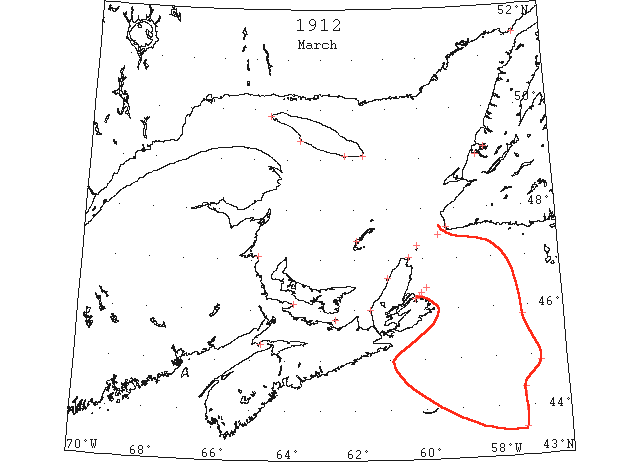
Mar 4 Anticosti, West Point and Southwest – No ice. Heath Point – Heavy close packed everywhere. Flat Point – Heavy close packed distant five miles. Northeast – Stationary. Point Amour – Heavy close packed ice, distant. (HH 04/03/1912 p11#4)
Mar 6 There is practically no ice in the Humber River. Until this last snap of frost it was open down to Brakes Cove. (TWS, p.2)
Mar 12 Both steamers are doing good work today in face of adverse conditions in the straits being full of heavy packed ice. (Pat 12 Mar p5#4)
Mar 12 The Reid Newfoundland steamer “Bruce” arrived at North Sydney yesterday afternoon after a forty hour trip from St. John’s. This is the first trip of the “Bruce” to the regular summer calling port. On the run across the south coast of Newfoundland the ship steamed and hunted her way though unusually heavy fields of drift ice, the heaviest perhaps that have visited the shores of the colony in a quarter of a century. The “Stanley” will take the mails to the Magdalen Islands. The steamer made the trip to the Islands once already this winter. The ship entered the drift ice some miles off the harbour entrance and had considerable difficulty in forcing her way through. Sydney Exc. (Pat 13 Mar p8#3)
Mar 15 Point Escuminac, St. Paul’s Island – Heavy close packed everywhere. Cape Tormentine, Magdalen Islands – Heavy open ice everywhere. Anticosti, West Point – Light close packed inshore. Southwest Point – No ice. South Point – Light open inshore. Money Point – Heavy open inshore, moving south. Cape Ray – Heavy close packed distant. Flat Point – Heavy open everywhere. (HH 16/03/1912 p13#3)
Mar 17 The “Minto” arrived in Georgetown at 8:30 Sunday morning. She got clear of the ice jam off Wood Islands Saturday afternoon but about dark ran into a heavy ice field which held her up for several hours. (Pat 18 Mar p8#3)
Mar 18 Anticosti, South West Point – Light open ice. Point Escuminac, Port Hood – Heavy close packed everywhere. Mulgrave Strait – Clear. Flat Point – Heavy close packed distant. Sydney Harbor – Partially clear. Cheticamp – Heavy close packed inshore. (HH 19/03/1912 p9#3)
Mar 20 It is reported that Hy. Sheppard’s motor boat which drifted from Lark Harbor during the blizzard of January 10, is in the ice at North Arm. (TWS,p.3)
Mar 20 Point Escuminac, Anticosti, South Point, Heath Point, St. Paul’s Island, Money Point – Heavy close packed everywhere. Magdalen Islands – Heavy open ice everywhere. Cape Ray – Heavy open distant. Flat Point – Heavy close packed distant. Mulgrave Strait – Clear. Port Hood – Heavy open ice. (HH 21/03/1912 p9#4)
Mar 22 Anticosti, West Point, Heath Point, Mulgrave, Flat Point, Cape Race – No ice. Cape Ray, St. Paul’s Island, Money Point – Heavy close packed everywhere. Port Hood Bay – Full stationary. (HH 23/03/1912 p13#3)
Mar 26 SS “Romsdal” 45°50’N 57°10’W in the afternoon saw an immense field of ice with a steamer of about 8000 tons fast in it. After dark the steamer commenced signaling for aid by rockets. Endeavoring to assist her and ran into the ice but we were compelled to stop, as the ice had injured the vessel in several place. About midnight the signaling ceased and all lights disappeared. She had probably sunk. Remained fast in the ice for 3 days. Finally forced a passage through the ice breaking the ends of the propeller blades and cracking and bending bow plates. (HB #1183 May 1)
Mar 27 SS “Romsdal” from Bergen for Halifax or Louisburg ran into ice 100m SE of Scaterie in which she damaged her bow, cracked 2 plates forward and bent and started rivets in several other plates. The ends were knocked off her propeller blades. (NYMR 10 Apr)
Mar 27 The westerly winds of last week jammed the gulf ice in tight to the shore at the outer part of the Bay. (TWS, p.2).
Mar 27 The mild weather of the first of last week accompanied by the frost of Thursday and Friday made splendid traveling on the Bay of Islands. (TWS, p.2).
Mar 27 Steamer “Kura” reports: 44°22’N 57°14’W, ice continuous and heavy, with large and solid floes and dense fog, and 43°34’N 57°14’W, cleared the ice. (NYMR, p.12, col.1)
Mar 27 Casualty report: “Kurn” [“Kura”] from Bremerhaven via St. John’s Mar 26, had 25 plates forward and frames damaged by collision with field ice on Mar 28; also had propeller broken; the steamer was in field ice for 36 hours; the vessel Apr 4 was being repaired in New York where she would be detained about 1 week. (NYMR 10 Apr)
Mar 27 The steamer “Romsdall” arrived at Louisburg yesterday from Bergen, after being damaged by the ice on hundred miles southeast of Scatterie Island, March 27th. Her bow is damaged, two plates are cracked and the rivets in several other plates are started, besides the ends are knocked off the propeller blades. A survey will be made to ascertain the full damage. (HH 03/04/1912 p9#4)
Mar 29 Halifax: Schooner “Annie Blanche” from Parrsboro 28th for Machiasport was crushed by drift ice below Spencer’s Island and sank. (NYMR 3 Apr)
Mar 29 The government steamer “Stanley” arrived last Thursday in Halifax with the mails from the Magdalen Islands. On the trip from the Magdalens the “Stanley” encountered much heavy ice and lost one blade off her propeller and had the ends of her other three blades broken. He rudder post was also damaged. She will go into dock at Halifax for repairs on her arrival there. (Pat 1 Apr p8#3)
Mar 31-Apr 2 SS “Mackey-Bennet” 44°52’N 56°45’W saw heavy field of ice in a field 10m wide; 2nd, 47°N 31[!]°03’W a large berg. (NYMR)
Mar 31 SS “Mackay-Bennett” 44°52’N 56°45’W: saw heavy field ice in a field 10 miles wide. (HB 1181 Apr 17)
Apr 1 J.A. Ward, Lightkeeper, Miscou Point, New Brunswick: Opening date. (CIS IC0756)
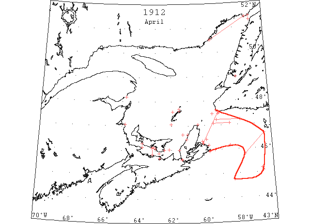
Apr 1 Quebec to Heath Point, Anticosti – Practically no ice. Flat Point, Cape Race – Scattered, no ice. Gut of Canso – Full heavy ice. Cape Ray – Heavy open inshore. Grindstone, Magdalen Islands – Heavy open distant on south side, heavy close packed everywhere on north side. Strait Northumberland – Heavy close packed everywhere. (HH 02/04/1912 p9#5)
Apr 1 After a hard battle with the ice the “Earl Grey” found it impossible to reach Charlottetown and this morning she gave up the struggle and returned to Georgetown. She will discharge freight there and leave for Pictou tomorrow. It is not likely that another attempt will be made to open this harbour until the ice is weakened by a heavy thaw or broken up by heavy winds. She went through considerable broken ice immediately after leaving Pictou. The Captain decided to go round the east end of Pictou Island and stood directly for the Island shore. His decision was well justified for he met open water all the way to Point Prim. Shortly after rounding the Point, the steamer encountered ice two feet thick, through which she made fair progress until she reached St. Peter’s bar. Here began the real siege of the day. Between St. Peter’s Island, stretching from shore to shore was found barrier of hard solid board ice, 42 inches thick on the level, with ridges indicating a greater thickness than this. She reached the barrier at 11 a.m. rammed away until noon, then ceased operations for half an hour until her furnaces were cleaned out. She resumed the fight again until 4 o’clock making about 60 feet at every charge and gain 4 miles in 3.5 hours. Owing to her formation she did not wedge in the ice, like the “Minto” or “Stanley” but was able to back out by her own efforts although finding it very difficult at times. The steamer kept pounding away at the ice during the afternoon and evening without making much progress finally reaching a point about 4 miles outside the blockhouse or 7 miles for the city. This morning she tried again but without success and at 8:30 she left for Georgetown. (Pat 1 Apr p1#6 & 7)
Apr 3 SS “Alexandria” 45°04’N 56°38’W saw drifting ice and ice fields. (NYMR)
Apr 3 SS “Haulwen” from Brake to Louisburg 44°45’N 58°20’W ran into an ice field and had bow plates indented. (NYMR 22 May 12.1)
Apr 3 44°45’N 58°20’W an ice field. (NYMR 22 May 12.3)
Apr 7 SS “Rosalind” 45°10’N 56°40’W ran into a strip of field ice ~3 or 4m wide, extending north and south as far as could be seen. Some very heavy pans were seen. (NYMR 24 Apr)
Apr 7 SS “Rosalind” 45°10’N 56°40’W: ran into a strip of field ice, about 3 or 4 miles wide, extending north and south as far as could be seen. Some very heavy pans were seen. (HB 1181 Apr 17)
Apr 8 Quebec to Anticosti, Cape Tormentine, Cape Ray, Flat Point – No ice. Port Hood, Cheticamp – Heavy open ice. Money Point – Heavy open, inshore. Cape Bear – Light open inshore. (HH 09/04/1912 p11#4)
Apr 10 The easterly winds of Wednesday took the ice off shore. (TWS, p.1).
Apr 10 The warm winds and sunshine Sunday and Monday made a big cutting on the snow and ice. (TWS, p.1).
Apr 10 The ice in Humber River is cutting down fast. Yesterday it was about to the railway pier. (TWS, p.1)
Apr 12 Point Maquereau – Light close packed inshore. Point Escuminac- Heavy close packed inshore. Cape Bear – Light open on Nova Scotia side. Magdalen Islands – North side five miles close packed ice outside open water; south side – no ice. Cape Ray – Heavy open ice. Cheticamp – Open ice distant. Money Point – Heavy close packed everywhere moving south. Anticosti, Flat Point, Cape Race and Scatterie – No ice. (HH 13/04/1912 p15#3)
Apr 13 Point Maquereau: light close-packed ice inshore. Point Escuminac: heavy close-packed ice inshore. Cape Tormentine: heavy open ice distant, moving south. Magdalen Islands: north side close-packed ice 5 miles offshore. Cape Ray: heavy open ice moving east. Money Point: heavy close-packed ice everywhere. Point Amour: heavy close-packed ice everywhere stationary. Belle Isle: heavy open ice inshore; heavy close-packed ice distant. Numerous icebergs. (HB 1181 Apr 17 CSS)
Apr 15 The SS “Seal” arrived at two this morning from St. John’s, Nfld., where she landed her catch. The “Seal” then proceeded, and succeeded in working her way through the heavy ice to a point some twelve miles north of Grindstone and there in company with the “Viking” and “Bloodhound” all got completely jammed. At this time the ships were not more than ten miles from the main patch of seals, and under ordinary circumstances should have reached the patch in twenty-four or thirty-six hours, but owing to the unusual conditions the ships held fast for twelve days. During this time the seals being further south and in the running ice, passed to the south of West Cape and before the ships could reach then the young seals had all taken the water and scattered in all directions. Up to this time the whole gulf fleet of eight ships was practically clean. On April 1st, near St. Paul’s Island, the “Sea;” found a small patch of young harps and secured about 3200. Owing to the exceptionally severe winter the ice in the gulf is very heavy and in very large sheets, making progress very difficult for the sealing fleet. (HH 15/04/1912 p11#5)
Apr 15 Point Maquereau: light close-packed ice inshore. Point Escuminac: heavy close-packed ice inshore. Cape Tormentine: light open ice inshore, moving north. Cape Bear: light open ice distant. Money Point: heavy close-packed ice everywhere. Port Hood: bay full of ice. Magdalen Islands: north side, heavy open ice inshore. Cheticamp: open ice distant moving south. Cape Ray: heavy open ice everywhere. Point Amour: heavy close-packed ice everywhere. Six bergs. Belle Isle: light open ice inshore. Heavy close-packed ice everywhere. Numerous bergs. (HB 1182 Apr 24 CSS)
Apr 16 Stations of the Canadian Signal Service report as follows: Point Marquereau, light close packed ice inshore; Point Escuminac, heavy close packed ice inshore; Cape Tormentine, no ice; Cape Ray, heavy open ice moving SE; Cape Race, 1 berg W; Money Point, heavy open ice inshore; Point Amour, heavy close packed ice everywhere moving E., 7 bergs; Belle Isle, light open ice everywhere, numerous bergs. (NYMR 24 Apr)
Apr 16 Point Maquereau: light close-packed ice inshore. Point Escuminac: heavy close-packed ice inshore. Money Point: heavy open ice inshore. Cape Ray: heavy open ice, moving SE. Point Amour: heavy close-packed ice everywhere, moving east. Six bergs. Belle Isle: light open ice everywhere. Numerous bergs. (HB 1182 Apr 24 CSS)
Apr 17 Point Maquereau: light close-packed ice inshore. Point Escuminac: heavy close-packed ice inshore. Cape Bear: light open ice. Money Point: heavy open ice moving SE. Belle Isle: open ice. (HB 1182 Apr 24 CSS)
Apr 18 Point Maquereau: light close-packed ice inshore. Point Escuminac: heavy close-packed ice inshore. Cape Ray: heavy open ice. Point Amour: heavy close-packed ice everywhere. Ten bergs. Belle Isle: numerous bergs. (HB 1182 Apr 24 CSS)
Apr 19 Point Escuminac- Heavy close packed inshore. Cape Ray – Heavy open ice. Scatarie – Light open ice distant. Money Point – Heavy open ice inshore. Port Hood, Flat Point, Anticosti, Cape Bear, Cape Tormentine – No ice. (HH 22/04/1912 p11#3)
Apr 19 The “Minto” got as far as the three tides only this morning. Captain Murchison finding the bay filled with heavy ice of the same character as that which he met when the steamer first broke into Charlottetown, wisely decided to return to Charlottetown and await more favourable conditions. He expects that the wind will drive out the ice today, and make a clear crossing tomorrow. (Pat 19 Apr p5#2)
Apr 20 Gloucester: The American schooner “Essex” which arrived here from Rose Blanche, W coast of Newfoundland, reports heavy field ice in the Gulf. They had to follow the shore down to Miquelon before they could shape a course in safety to clear the ice that was between them and Scatari. When 15 miles SW from Miquelon they made heavy ice extending for 70 miles. The schooner was fast in the ice for 30 hours and from the deck several ordinary sized icebergs were seen. Captain said that he had recently seen was the heaviest ice he had ever seen. (HB #1182 Apr 24)
Apr 20 Point Maquereau: light close-packed ice inshore. Money Point: heavy open ice moving SE. Magdalen Islands: north side, 1/2 mile loose ice inshore; south side, no ice. Cape Ray: heavy open ice. Point Amour: heavy close-packed ice everywhere. Numerous bergs. (HB 1182 Apr 24 CSS)
Apr 21 Quebec to Anticosti, Magdalen Islands, Money Point, Cape Ray, Flat Point – No ice. Steamer “Bruce” reports met no ice from Port Aux Basque to Flat Point. (HH 22/04/1912 p15#5)
Apr 22 Money Point: heavy close-packed ice everywhere. Flat Point: heavy open ice 2 miles east. Magdalen Islands: north side packed ice; south side no ice. Scatari: strip of ice south. Flint Island: head[sic? = heavy??] ice going out easterly. Cape Ray: heavy open ice moving SE. Point Amour: heavy, close-packed ice distant, ten bergs. Belle Isle: numerous bergs. (HB 1183 May 1 CSS)
Apr 24 North Shore: Harrington to Blanc Sablon, heavy close-packed ice everywhere. Cape Ray: heavy open ice moving SE. Point Amour: heavy, close-packed ice everywhere. Belle Isle: numerous bergs. (HB 1183 May 1 CSS)
Apr 24 SS “Bruce”: arrived at North Sydney from Port aux Basques and reports met ice 5 miles from Channel Head; passed [text lost]. (HB 1183 May 1)
Apr~25? SS “Bruce” reports very heavy ice from Port aux Basques to Flat Point, with no open water. [HH?]
Apr 25-26 Quebec, to the Canada liner “Zeiten” belongs the honor of inaugurating the season of navigation between this port and the far side of the Atlantic for 1912. The “Zeiten” reports that 30 miles south of Cape Ray the first drift ice was met on April 25,at 11 p.m., and that the vessel pressed through it for sixty miles, not clearing it until April 26, at 6:30 a.m. No further trouble with ice was experienced. (HH 29/04/1912 p1#3)
Apr 26 Money Point: heavy open ice. Flat Point: heavy open ice distant. Point Amour: light close-packed ice distant, moving west, thirteen bergs. Belle Isle: numerous bergs. (HB 1183 May 1 CSS)
Apr 26 SS “Ardanmhor” 46°10’N 58°30’W: passed a lane of drift ice extending in a NW and SE direction to the horizon. (HB 1184 May 8)
Apr 27 Flat Point: heavy open ice distant 5 miles northward. Cape Ray: heavy open ice distant. Point Amour: heavy, close-packed ice everywhere, thirteen bergs. Belle Isle: numerous bergs. (HB 1183 May 1 CSS)
Apr 28 First arrival of season at Quebec. (WBB)
Apr 29 Stations of the Canadian Signal Service report as follows: Point Escuminac, heavy open ice inshore; Flat Point, heavy open ice everywhere moving south; Point Amour, light close packed stationary, 11 bergs; Belle Isle, numerous bergs. (NYMR 8 May)
Apr 29 SS “Whakatane”: about 10 miles SE of Cape Ray, encountered thick field ice and steamed through 25 miles of it. (HB 1184 May 8)
Apr 30 SS “Pretorian”: first met ice 47 miles SE of Cape Ray. Ice pretty loose, with some heavy pieces, till[sic] abreast of Cape Ray; ice much the same. Past Cape Ray ice much thinner, with good clear water between fields. Last ice 40 miles west of Cape Ray. (HB 1184 May 8)
Apr 30 SS “Englishman”: steamed through 30 miles of gulf ice inside of Cape Ray. (HB 1184 May 8)
May 1 The warm winds and bright sunshine of the past few days are causing the snow to rapidly disappear. The ice in the Humber has become unsafe to go on. (TWS, p.2).
May 1 Issue: SS “Bruce” arrived at North Sydney from Port aux Basques met ice 5m from Channel Head, passed through 25m of loose ice, none from that to Sydney. (NYMR)
May 1 Issue: Heavy ice in gulf, west coast and around Miquelon. (NYMR)
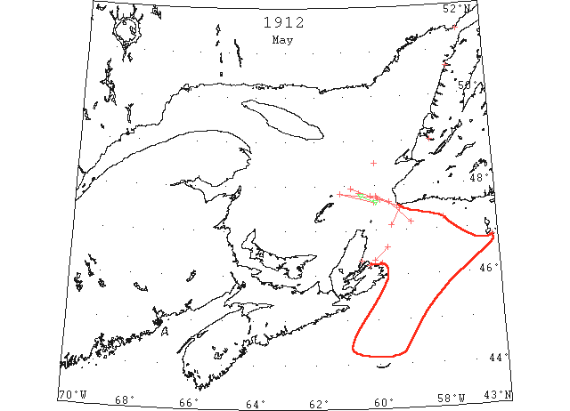
May 1 47°10’N 58°50’W heavy field ice, but a clear passage along coast of Newfoundland to 10m W of Cape Ray; then through 20m intermittent patches of field ice on N65°W course, thence coast clear of ice. (NYMR 15 May)
May 1 SS “Bruce” passed through 25m closely packed ice 5m from Flat Point, some heavy, then 30m clear water and loose ice from there to within 5m of Channel Head. (NYMR 15 May)
May 1 SS “Montezuma”: met heavy field ice 47°10’N 58°50’W, with clear passage along coast of Newfoundland to 10 miles west of Cape Ray; then passed through 30 miles intermittent patches of field ice on N. 65° W. (true) course; then found coast clear of ice. (HB 1184 May 8)
May 1 SS “Bruce”: passed through 25 miles closely packed ice, 5 miles from Flat Point, some heavy; then 30 miles clear water and loose ice from there to within 5 miles of Channel Head. (HB 1184 May 8)
May 1-4 SS “Devona” 47°15’N 57°45’W thick field ice. 2nd.,48°30’N 60°W thick field ice; and May 4, St. Lawrence River, some heavy pieces of ice drifting downstream. (HB #1185 May 15)
May 2 SS “Willehad” passed Cape Ray 5m off, from there to 30m N of St. Paul’s Is. heavy field ice; last ice seen 25m E of Bird Rocks. (NYMR 15 May)
May 2 SS “Willehad”: passed Cape Ray 5 miles off; from there to 30 miles north of St. Paul Island heavy field ice. Last ice seen 25 miles east of Bird Rocks. (HB 1184 May 8)
May 3 47°44’N 59°57’W light field ice. (NYMR 15 May)
May 4 47°41’N 59°50’W to 47°57’N 60°48’W broken patches of field ice. (NYMR)
May 4 SS “Hesperian” 47°44’N 59°57’W entered light field ice; and May 5 off Bird Rocks cleared the ice. (HB #1185 May 15)
May 4 Cape Ray: no ice. Point Amour: light, close-packed ice everywhere, moving west. Six bergs. Belle Isle: heavy open ice everywhere, moving west. (HB 1184 May 8 CSS)
May 5 SS “Ultonia” from Southampton to Montreal arrived Halifax in a disabled condition having lost her port propeller in an ice field off Sable Is. (NYMR 8 May)
May 5 Sydney Harbour, heavy open ice stationary. Point Amour, heavy close packed ice everywhere moving W. (HB #1185 May 16)
May 5 SS “Andijk” from 30 miles W of Cape Ray to Bird Rocks steamed through a large field of ice. (HB #1185 May 15)
May 7 SS “Brand” from St. Anns, CB to Philadelphia was delayed 3 days on entering and 4 days on leaving St. Anns on account of the ice. On May 7 she passed field ice for 4 hours E of Sydney. (NYMR 22 May 12.3)
May 7 SS “Ramore Head” from Cape Ray to Bird Rocks passed through field ice some of which was heavy. (HB #1185 May 15)
May 7 SS “Royal Edward” en route from Cape Ray to Bird Rocks steamed for 20 miles through loose field ice. (HB #1185 May 15)
May 8 Navigation is now open in Bay of Islands. (TWS, p.2)
May 8 The ice in the Humber drifted out on Saturday. (TWS, p.2)
May 8 SS “Koln” 47°37’N 59°58’W to 47°47’N 60°29’W heavy masses of growlers. (HB #1185 May 15)
May 11 Point Amour, heavy close packed ice distant; light open ice inshore. (HB #1185 May 16)
May 14 Schooner “Edith Emery” from Port Saunders with fishery supplies and 36 passengers was crushed in the ice 3m off Keppel Is. [50° 38’N – 57° 19’W], and sunk in 20 minutes. Crew and passengers reached shore after a trying experience. (NYMR 22 May 12.1)
May 15 The stations of the Canadian Signal Service report as follows: Point Amour, heavy close packed ice everywhere; Belle Isle, heavy close packed ice everywhere, numerous bergs. (NYMR 22 May 12.3)
May 24 Point Amour, heavy close packed ice everywhere stationary. (HB #1187 May 29)
Jun 1 Point Amour, heavy close packed ice everywhere moving E. (HB #1188 Jun 5)
Jun 10 First Westbound steamer through the strait of Belle Isle. (WBB)
Jun 14 Point Amour, light open ice everywhere moving E. (HB #1190 Jun 19)