1911 Season
Nov 20-26 No ice reported to the stations of the Canadian Signal Service. (HB #1109 Nov 30, 1910)
Nov 27 – Dec 3 Inclusive; No ice reported to the stations of the Canadian Signal Service. (HB #1110 Dec 7, 1910)
Dec 2 Last departure of the season from Quebec. (WBB)
Dec 5 Last eastbound steamer through the Strait of Belle Isle. (WBB)
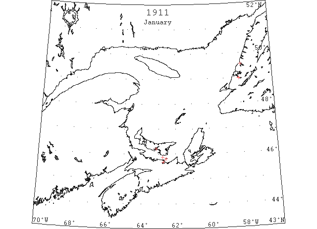
Jan 7 The Winter Boats – Both the “Earl Grey” and the “Minto” are not making regular daily trips between Charlottetown and Pictou, the time of passage being between three and a half and four hours. Although the ice is a little heavier in the Straits than a short time ago, still the excellent time made by both boats shows that these powerful ice breakers experience but little difficulty on their trips. The weather is mild for this time of year and present indications are for a not very severe winter. (Pat 7 Jan p4#4)
Jan 11 At last reports from Bay of Islands, there was no ice except in the Humber and no word of ice to the northward and heading down the gulf has yet been received. (HH 11/01/1911 p11)
Jan 11 The “Earl Grey” arrived here at 10:25 making the trip in exactly 3 hours and 5 minutes. A little scattered ice was met with the bay having cleared out since yesterday. Up to the present there has been less ice in the Straits than this time last year. (Pat 11 Jan p8#5)
Jan 13 There is no ice at Anticosti, on either side of the island, so it may be that Bay of Islands will not be closed for some time yet by gulf ice, although ice in the Humber and Middle Arms may come any time. (HH 13/01/1911 p9#6)
Jan 18 Sunday afternoon the “Fiona” went to the rescue of a fishing boat and crew which had got caught in the ice in middle of Humber Arm. (TWS, p.2)
Jan 18 With the thermometer twelve below zero and the ice solid in the harbour Captain Angus Brown brought the good ship “Earl Grey” into Charlottetown this noon. (Pat 18 Jan p1#4)
Jan 18 The “Earl Grey” docked in Charlottetown at 12:30 today after a hard battle with the ice. This was the first time she was put to a good test and she behaved splendidly. The straits are full of ice, the heaviest being between Pictou and Pictou Island. The only open water met with was a patch near the block house. (Pat 18 Jan p5#2)
Jan 19 No gulf ice reported anywhere in the Gulf of St Lawrence. (HH 19/01/1911 p9#5)
Jan 23 Bay of Islands:- Retreating before the southward movement of the icebergs along the Newfoundland coast, the Gloucester fishing fleet has abandoned the season’s herring fishery. [goes on to say that only 5 of 19 vessels secured full cargoes]. (HH 24/01/1911 p1#6)
Jan 25 There is no report of drift ice being on the Bay of Islands coast. (TWS,p.2).
Jan 25 The American schooner “Constellation” is yet frozen in the ice near Meadows Point. Should the drift ice keep off the vessel may get out within a few days. (TWS, p.2).
Jan 25 Herrings are now being caught through the ice in Humber Arm. (TWS, p.2).
Jan 25 There were seven Gloucester vessels frozen in at Bonne Bay yesterday and it is likely they will have to remain there all the winter. (TWS, p.3).
Feb 1 The Nova Scotia schooner “Earl V. S.” met ice off Port au Port last week and returned to Middle Arm. (TWS, p.2).
Feb 1 The Gloucester schooner “Thos Cromwell” is frozen in at Frenchman’s Cove where she will likely have to remain till spring, unless we should get a mild spurt. (TWS, p.2).
Feb 1 Report reaches that a vessel supposed to be the Gloucester schooner “Aloha” is in the ice at the mouth of Bay of Island. (TWS, p.2).
Feb 1 The crew of the Gloucester schooner “Constellation” left for Gloucester Friday. The schooner is hard and fast in the ice down the Humber and there she is likely to remain till spring. (TWS, p.2)
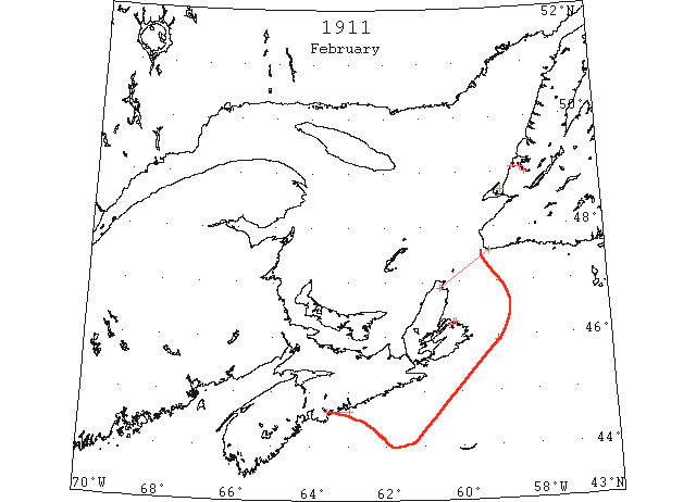
Feb 13 North Sydney,– The steamer “Bruce” was five miles off North Sydney this evening battling with drift ice, in an effort to enter port. (HH 14/02/1911 p11)
Feb 14 Mail Steamer “Bruce” has been stalled in the ice at Cabot Strait for three days. (NYMR, p.12, col.1)
Feb 14 French cable steamer “Contre Amiral Caubet” encounters field ice “forty miles east of Louisburg.” It was “about a foot in thickness and extended as far as the eye could see. It was scattered ice.” (HH 14/02/1911 p9)
Feb 15 Mr. Norman informs us that the ice in the Gulf is the heaviest he has seen there for the past twelve years. (TWS, p.2).
Feb 15 There is a heavy pack of ice off the Cape Breton Coast. (TWS, p.2).
Feb 15 The SS ”Bruce” lost one trip last week owing to the ice in the Cabot Straits. (TWS, p.2).
Feb 16 Cable Steamer “Contre Amiral Caubert” arrived Halifax leaking badly after contact with ice south of St.Pierre. (NYMR)
Feb 19 [See March 16 entry for HH]
Feb 22 Captain Jerry Cook arrived from Gloucester Sunday night to look after the “Constellation”, now frozen in at Meadows and to purchase a cargo of pickled herring for shipment in the spring. (TWS, p.2)
Feb 24 “A well known commander of a transatlantic liner in conversation with a Herald reporter a few days ago, made the statement that not for years had he seen so much ice off the coast and on the banks.” (HH 24/02/1911 p11#4)
Feb 25 SS “Empress of Britain” from Halifax to 25m to the eastward on a S 67°E course saw a quantity of slob ice. (NYMR 15 Mar)
Feb 25 Steamer “Corisean” reports in 44°11’N 62°08’W saw slush ice and pans of new ice. (NYMR, p.11, col.5).

Mar 1 Last week it was stated that ice of the heaviest kind extended from shore to shore in the Cabot Strait, forming a bridge from Cape Breton to Newfoundland, and that travelers from this country have walked ashore at Sydney. (TWS, p.3).
Mar 1 There were 83 clearings from American ports for the west coast herring fishery the past season. Of this number, one is frozen in at Bonne Bay, 3 are at Bays of Islands, and one has not been heard of since she sailed from here on January 23. The others have all returned safely home ports. (TWS, p.3)
Mar 2 Capt Pickett of Channel Nfld arr. Sydney en route to NY, says “southern ports of Nfld [are] hemmed in by enormous fields of drift ice and he prophesies that this spring will witness the latest opening for many years. Similar conditions prevail along the east coast, the ocean, from Labrador to Cape Race, being covered by floes.” (HH 02/03/1911 p11)
Mar 3 Glace Bay: Asst Gen Mgr D.H. McDougall of Dominion Coal company, returned today after 2 wk trip to Nfld; experienced great difficulty in getting to St John’s owing to the drift ice, and stated that the ice conditions in the gulf were the most serious in years and that unless the heavy fields of ice were driven into the [illegible – probably “gulf”] stream by storms it would interfere greatly with shipping this spring and render opening of navigation very late.” (HH 03/03/1911 p2)
Mar 7 Steamship “Shenandoah” from London via St John’s reports tremendous Fields of Ice on This Coast. Ice Was First Met With 260 Miles East of Nfld. The chief officer says that it was the largest field of ice that he ever saw. He says that the field must have extended over one hundred miles. [Eventually got clear of the field but could not enter St John’s due to ice – forced to stay outside harbour]. From St John’s the ship “encountered ice most of the way to Halifax.” (HH 07/03/1911 p1)
Mar 7 [First Ice Report of season]: “Heavy close packed ice everywhere” in Gulf of St Lawrence except for Mulgrave and Gut of Canso which are reported “Clear of ice.” (HH 07/03/1911 p9)
Mar 9 Canadian Signal Service stations reported ice in the St. Lawrence River and Gulf; also heavy close packed ice everywhere at Point Amour and Belle Isle. (NYMR 15 Mar)
Mar 9 Heavy close packed ice everywhere in Northumberland Strait & Magdalen Islands. At Cape Ray, Heavy open ice distant. At Heath Point, Heavy close packed distant. (HH 09/03/1911 p11)
Mar 11 Heavy close packed ice everywhere in Gulf of St. Lawrence. Heavy open ice distant at Cape Ray. Light open ice everywhere at Anticosti. (HH 11/03/1911 p13)
Mar 13 Canadian Signal Service reports heavy open ice distant off Cape Ray. (NYMR)
Mar 14 Cape Traverse, Cape Tormentine, Flat Pt, Point Armour, Belle Isle – Heavy close packed ice everywhere. Quebec to Father Pt – No ice. [Note: this is due to 2 govt icebreakers working in the area]. Magdalen Islands – Heavy open ice, moving east. St Paul’s Island – Heavy open ice stationary. (HH 14/03/1911 p11)
Mar 14 Ice reports show that the amount of ice in the gulf is unprecedentedly large this year. (HH 14/03/1911 p11#5)
Mar 16 Re Sydney harbour: “Mr. Peters, keeper of the Low Point light keeps an official record of the ice conditions of the harbor. Mr. Peters has been in charge of the light here for the last forty-five years, and stated that at no time in his recollection were the ice conditions as reported in The Herald, and that there was no barrier of ice extending across the mouth of the harbor as the paper stated. The ice report, as furnished by Mr. Peters, from his official record book, Feb 19th to the present was as follows: Feb 19, 20, 21 – clear light ice; 23, local ice, bay clear and continued clear until 28th, when drift ice appeared. March 1 – scattered ice outside. March 5 – light ice more or less inside. March 6 thru 10 – heavy ice drifting. March 11 – bay clear scattered ice. The ice was driven out to-day and the [Sydney] harbor is clear but for light ice. (HH 16/03/1911 p1#4)
Mar 17 The stations of the Canadian Signal Service report ice in the St. Lawrence River and Gulf; also heavy close packed ice everywhere stationary at Cape Ray; heavy close packed ice everywhere moving E at Point Amour, and heavy close packed ice everywhere at Belle Isle. (HB #1125 Mar 22)
Mar 18 The great ice field extending from the Gulf of St. Lawrence and through the Cabot Strait to the east and southward, has forced its way onto Quero [Banquereau] Bank. (HH 18/03/1911 p13#4)
Mar 20 SS “Jeseric” from Hull to New York 44°39’N 67[probably 47]°35’W in dense fog ran into a field of ice and cleared it 6½ hours later. When fog lifted sighted several small bergs. (NYMR 29 Mar)
Mar 21 Magdalen Islands & Cape Ray – Heavy open ice distant. Cape Despair, South Point, Heath Point, Pt Escuminac, Cape Tormentine, Cape Traverse, Cape Bear, St Paul’s Island – Heavy close packed everywhere. Money Point – Heavy close packed ice. (HH 21/03/1911 p11)
Mar 22 Steamer “Bruce” arr Louisburg from Port aux Basques. Was caught in the ice and carried over ten miles off her course in a heavy storm before freeing herself from the floes. The ice is clearing pretty well out of the course and little difficulty is expected on this trip. (HH 22/03/1911 p11#5)
Mar 23 Magdalen Islands, Money Pt and St Paul’s Island – Heavy close packed ice. Pt Escuminac, Cape Tormentine, Cape Traverse, Cape Ray, Point Amour, Belle Isle – Heavy close packed everywhere. Cape Bear – Heavy open ice. (HH 23/03/1911 p9)
Mar 25 The stations of the Canadian Signal Service report ice in the St. Lawrence River and Gulf; also light open ice distant at Cape Ray; heavy open ice moving SE at St. Pauls Island; heavy close packed ice everywhere moving E at Point Amour, and heavy close packed ice everywhere at Belle Isle. (HB #1126 Mar 29)
Mar 25 Magdalen Islands, Money Pt & St Paul’s Island – Heavy close packed ice. Ice everywhere in Northumberland Strait. Cape Ray – Heavy open ice everywhere. (HH 25/03/1911 p13)
Mar 28 SS “Florida” 40°37’N 69°22’W passed some pieces of field ice. (NYMR)
Mar 28 SS “Florida” 40°37’N 69°29’W passed some pieces of field ice. (HB #1127 Apr 5)
Mar 29 Capt. Jerry Cooke was in the Bay of Islands Saturday. He is anxiously awaiting the lifting of the ice embargo to get away. (TWS, p.2).
Mar 29 Capt. I. Zinc and J. Park were in the Bay of Islands Monday. Capt. Zinc is another unfortunate mariner held prisoner by the ice. (TWS, p.2)
Mar 30 Montreal paper quotes Marine & Fisheries Dept agents as saying that navigation to Montreal won’t be possible before April 20th — two weeks later than the previous year. Not only is there ice in the St. Lawrence River, but the quantities which have been met with off the coast have been almost unprecedented. (HH 30/003/1911 p11#4)

Apr 1 L’Islet, light open ice. Point Maquereau, heavy open ice moving SE. Southwest Point, light open ice distant. Point Escuminac, heavy close packed ice everywhere moving E. Cape Tormentine, heavy close packed ice inshore. Cape Traverse, light open ice. Cape Bear, light open ice. Port Hood, heavy close packed ice everywhere. Magdalen Islands, heavy open ice inshore moving W. Money Point, light close packed ice everywhere moving SE. St. Pauls Island, heavy open ice distant moving E; also heavy close packed ice everywhere stationary at Cape Ray. (HB #1127 Apr 5)
Apr 1 Heavy close packed ice everywhere in Northumberland Strait and around Magdalen Islands. (HH 01/04/1911 p11)
Apr 2 A passenger who crossed to the Island by the “Earl Grey” last Sunday says that the steamer made strenuous efforts to reach this port, but the ice blocked conditions of the strait could not be overcome. The straits were filled with a solid pack to the westward as far as the eye could see. Conditions will not be favourable for again trying for here until there comes a heavy northern breeze to drive the ice off the Island Shore; followed by a south wester to send it down the Gulf. (Pat 4 Apr p5#2)
Apr 4 The stations of the Canadian Signal Service report ice in the St. Lawrence Gulf; also heavy close packed ice everywhere moving SE of Cape Ray; heavy close packed ice everywhere moving E of Point Amour, and heavy packed ice everywhere at Belle Isle. (NYMR 12 Apr)
Apr 6 The stations of the Canadian Signal Service report ice in the St. Lawrence Gulf; also heavy open ice everywhere moving NW at Cape Ray; no ice at Cape Race. (NYMR 12 Apr)
Apr 7 SS “Harlaw” abandoned in sinking condition near St. Paul’s Is. (NW).
Apr 7 Cape Salmon, light open ice. South Point, light close packed ice inshore. Cape Tormentine, heavy open ice. Cape Traverse, heavy close packed ice everywhere. Cape Bear, heavy open ice. Port Hood, heavy close packed ice everywhere. Magdalen Islands, heavy open ice everywhere moving N. Money Point, heavy close packed ice everywhere moving N. Flat Point, heavy close packed ice everywhere distant moving SE. St. Pauls Island, heavy close packed ice everywhere stationary. (HB #1128 Apr 12)
Apr 7 Cape Ray, Port Hood – Heavy open ice. Cape Salmon – Light open ice everywhere. Cape Traverse, Cape Bear, Cape Tormentine, Flat Point – Heavy close packed ice everywhere. (HH 07/04/1911 p11)
Apr 10 The stations of the Canadian Signal Service report ice in the St. Lawrence Gulf; also close packed ice everywhere moving SE of Cape Ray. (NYMR 19 Apr)
Apr 12 Ice has considerably interrupted in the operations of the cod fishery along the South Coast the past two or three weeks. (TWS, p.2)
Apr 13 The “Minto” arrived in Charlottetown this forenoon. The captain first thought of going to Georgetown but as there was a good opportunity to reach here today the heavy north wind having blown the ice off the Island shores, he decided to come to Charlottetown. Both the “Minto” and the “Earl Grey” came round the east end of Pictou Island today. There is still a large quantity of ice in the straits, but it is on the mainland side. (Pat 13 Apr p5#6)
Apr 14 The stations of the Canadian Signal Service report ice in the St. Lawrence Gulf; also no ice at Cape Ray or Cape Race. (NYMR 26 Apr)
Apr 15 The stations of the Canadian Signal Service report ice in the St. Lawrence Gulf; also no ice at Cape Race; heavy close packed ice everywhere at Point Amour. SS “Earl Grey” reports Northumberland Strait full of heavy ice. (NYMR 26 Apr)
Apr 15 The stations of the Canadian Signal Service report ice in the St. Lawrence Gulf; also heavy open ice distant moving east at Point Amour. (NYMR 19 Apr)
Apr 15 SS “Earl Grey” reports solid ice from E end of Pictou Island to Point Prim and Nova Scotia shore. Lead of open water along PEI shore due to several days of N wind. (NYMR 19 Apr)
Apr 15 Cape Traverse: heavy open ice. Cape Tormentine: heavy close-packed ice inshore; heavy open ice outside. Mulgrave: considerable ice drift. Port Hood: ice packed along shore. Cheticamp: light scattered ice offshore. Magdalen Islands: light open ice everywhere. Point Amour: heavy close-packed ice everywhere. The British steamer “Earl Grey” reports that the Northumberland Strait is full of heavy ice. (HB 1129 Apr 19 CSS)
Apr 17 Schooner “A K McLean” from Louisburg to St. John’s crushed by ice off Cape Esprit, Cape Breton and abandoned. (NYMR)
Apr 17 The stations of the Canadian Signal Service report ice in the St .Lawrence Gulf; heavy close packed ice everywhere at Point Amour. (NYMR 26 Apr)
Apr 17 Things are beginning to move with the spring weather around the wharves; steamers have broken up the ice considerably and the harbour is clearing fast. Several pleasure boats are now ready for the coming season, and now only await the clearance of the ice and the arrival of the warmer weather. (Pat 17 Apr p8#3)
Apr 17 The “Minto” was held up for several hours yesterday by the ice off Point Prim and did not reach here till 8. (Pat 18 Apr p8#3)
Apr 18 The stations of the Canadian Signal Service report ice in the St. Lawrence Gulf; heavy close packed ice everywhere at Point Amour and heavy close packed ice distant at Cape Ray. (NYMR 26 Apr)
Apr 19 The ice in the Humber is fast disappearing before the warm winds and powerful rays of the sun. (TWS, p.3).
Apr 20 Ice in the St.Lawrence Gulf; also light close packed ice inshore at Point Amour. SS “Earl Grey” reports ice still on island shore from Wood Is. to Point Prim; also considerable heavy ice on Nova Scotia shore owing to northerly winds. (NYMR 26 Apr)
Apr 22 Cape Traverse: heavy, open ice about 1 mile offshore. Cape Tormentine: heavy, close-packed ice inshore. Port Hood: very little ice in sight. Magdalen Islands: heavy, close-packed ice everywhere. Money Point: heavy, close-packed ice everywhere. St. Paul Island: heavy, close-packed ice everywhere. Flat Point: heavy, close-packed ice everywhere. Point Amour: light, open ice everywhere. (HB 1130 Apr 26 CSS)
Apr 25-27 SS “Corsican” 47°52’N 60°08’W saw a field of ice extending as far to the NW as could be seen. (NYMR 10 May)
Apr 27 First arrival of season at Quebec. (WBB)
Apr 27 Halifax: There are good prospects now for the early opening of the Gulf of St. Lawrence. Government str. “Montcalm” reports the ice off the east coast to be moving under the influences of a light westerly wind and that several others sections of the gulf coast are now clear of ice. (NYMR 3 May)
Apr 27 The stations of the Canadian Signal Service report as follows: Cape Traverse, very little ice; Cape Tormentine, heavy open ice distant; Cape Bear, loose ice on Nova Scotia shore; Cheticamp, strip of light ice moving east; Magdalen Is, light close packed ice inshore; Money Point, light open ice distant moving east; St. Paul’s Is, light open ice moving south; Flat Point, heavy close packed ice distant, heavy open ice inshore; Cape Race, icebergs everywhere; Point Amour, heavy open ice everywhere with icebergs. (NYMR 3 May)
Apr 27 SS “Empress of Ireland” 47°20’N 62°40’W body of light field ice. (NYMR 10 May)
Apr 27 Lat 47°52’N lon 60°03’W, a field of ice extending as far to the NW as could be seen. (NYMR, p.11, col.1)
Apr 27 SS “Corsican” 47°52’N 60°05’W: saw a field of ice extending as far to the NW as could be seen. (HB 1132 May 10)
Apr 29 SS “Fremona” 45°37’N 58°32’W encountered field ice and continued in the ice to Louisburg. (NYMR 17 May)
Apr 29 SS “Montrose” 40 miles ENE of Magdalen Islands heavy packed ice to NW, and S solid to the horizon with clear water E of ice. (HB #1131 May 3)
Apr 29 SS “Fremona” 45°37’N 58°32’W encountered field ice and continued in the ice to Louisburg. (HB #1133 May 17)
Apr 29 SS “Dominion” 47°41’N 59°36’W: 7.45 p.m., entered field ice, consisting of small pieces, which extended as far as could be seen toward S. by W. Large patches of clear water to be seen. At 10 p.m. 47°56’N 60°11’W, ice closer packed and in larger pieces. (HB 1132 May 10)
Apr 30 Flat Point, heavy open ice everywhere. Point Amour, heavy close packed ice distant, moving S. Open water along N shore as long as can be seen. (HB #1131 May 3)
Apr 30 SS “Dominion” 48°04’N 60°39’W: 3 a.m., cleared the ice. (HB 1132 May 10)
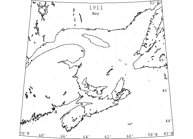
May 1 SS “Cassandra” 47°53’N 60°03’W entered field ice; cleared it in 47°56’N 60°08’W; 48°08’N 60°-‘[34’]W entered field ice; cleared it in 48°12’N 60°43’W. (NYMR 17 May)
May 1 SS “Cassandra” 47°53’N 60°03’W: entered field ice; cleared it in 47°56’N 60°08’W. 48°08’N 60°34’W: entered field ice; cleared it in 48°12’N 60°43’W. (HB 1132 May 10)
May 6 Point Amour: light open ice everywhere. Belle Isle: light open ice inshore, with icebergs. (HB 1132 May 10 CSS)
May 10 First Westbound steamer through the strait of Belle Isle. (WBB)
May 10 Issue: SS “Earl Grey” reports eastern and Northumberland Straits full of drift ice extending 8m W of Gull rock and across straits. (NYMR 10 May)
May 10 The “Earl V. S.”, Capt. Zinc, after being frozen in Middle Arm all winter, got away last week. (TWS, p.2).
May 10 SS “Empress of Britain” 46°44’N 57°58’W passed 2 small icebergs. (HB #1134 May 24)
May 11 The stations of the Canadian Signal Service report as follows: Point Amour, light open ice everywhere; Bell Island, light open ice inshore, with bergs. (NYMR 17 May)
May 13 Point Amour, light open ice everywhere moving W. (HB #1133 May 17)
Jun 4 Point Amour, heavy close packed ice distant moving W. (HB #1136 Jun 7)