Jan 6 There is some talk about the “Stanley” coming to this port now that the ice is about breaking up. On enquiring at the Marine Department, however, we learn that Capt. Finlayson reports the straits full of heavy ice and that it would be simply impossible to run the “Stanley” to this port with any kind of regularity. Under these circumstances, she will continue the Georgetown Pictou route. (Pat 6 Jan P5#2)
Jan 9 The “Stanley” left Pictou at 1:30 this afternoon for Charlottetown. Outside the harbour, viewed from the Provincial Building, appears to be open water and it is thought the “Stanley” will not have much difficulty in making this port. (Pat 9 Jan p2#6)
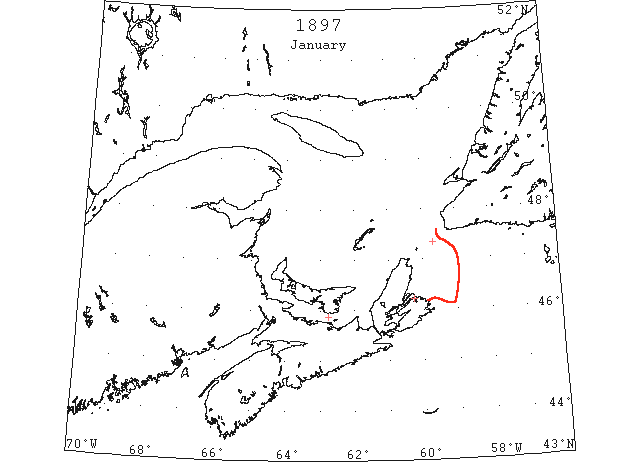
Jan 25 Fishermen arriving at Gloucester, Mass. Report drift ice between Scatari and the S shore of Newfoundland. (HB #387 Jan 27)
Jan 27 North Sydney: navigation closed. (LL)
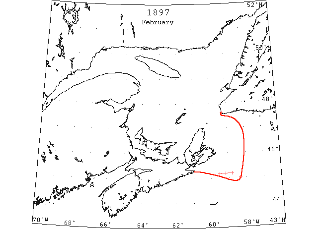
Feb Cape Ray, heavy close packed sheet ice all around for 13 days during February. No icebergs during the month. (HB #400 Apr 28)
Feb 16 SS “Naparima” 45°10’N 59°10’W met a field of slob ice reaching E and W as far as the eye could see; steered S for 4 hours to clear it. Later passed through a field of dense slob ice which nearly stopped the ship. Saw the last of the ice in 45°N 58°20’W. (HB #394 Mar 17)
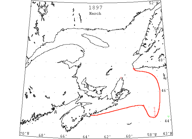
Mar At Port Basque (Channel Head) the harbour was frozen up from Mar. 1 to 25 and drift ice was in sight daily, sometimes being jammed in to shore. (HB #398 Apr 14)
Mar Cape Ray, heavy drift ice up to the 25th, afterwards very light. No icebergs during the month. (HB #400 Apr 28)
Mar 6 SS “Scotia” which put into Halifax short of coal passed through heavy fields of ice for a hundred miles while off the Newfoundland coast. (HB #393 Mar 10)
Mar 17 Quebec, Grosse Isle quarantine station, L. Iglet [L’Islet], and Little Metis report the St. Lawrence river free of ice. (HH 18/03/1897 p2#3)
Mar 18 SS “Scotsman” from Liverpool to Halifax 44°16’N 56°15’W passed a small berg; 44°40’N 57°30’W met field ice extending north and south as far as could be seen. (NYMR)
Mar 18 “SS “Minister Maybach” 44°48’N 57°05’W crossed a thick field of ice 1 ½ miles wide and 12 miles long; Mar 19, passed field ice in 45°08’N 58°30’W. (HB #396 Mar 31)
Mar 18 Meat Cove, fine warm, calm; heavy close packed ice moving southeast. Ice as far as can be seen from Halifax. (HH 19/04/1897 p4#3)
Mar 20 (cf Mar 18) SS “Scotsman” 44°17’N 57°37’W passed a large quantity of field ice reaching in a narrow strip N and S as far as the eye could see. (HB #396 Mar 31)
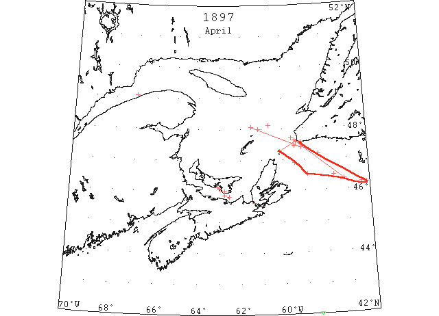
Apr Channel Head, the drift ice would come and go with the wind during the month of April. No bergs sighted. (HB #405 Jun 2)
Apr 2 SS “Durango” from Rotterdam to Baltimore 42°48’N 48°50’W saw heavy packed ice; 42°N 58°30’W saw a very large berg. (NYMR)
Apr 13 The “Stanley” we are pleased to hear, reached Pictou this morning at 10 o’clock. She will not leave there until tomorrow morning, and it will depend entirely on the state of the ice whether she will attempt to come to Charlottetown or not. (Pat 13 Apr p3#2)
Apr 17 The “Stanley” left Pictou this morning for Charlottetown but found heavy ice off Wood Islands. After remaining near the ice for nearly two hours she proceeded to Georgetown arriving there about 11 this forenoon. (Pat 17 Apr p2#3)
Apr 20 Gloucester, Mass, incoming fishing vessels report dense fields of ice off the Newfoundland coast. Captain Thomas Behlin, of the schooner “Nannie T Bohlin,” arrived here to-day and reports that on the afternoon of April 20, while fishing with three other vessels, the wind drove an immense field of ice, which forced the vessels into Port au Basque, where they were imprisoned for ten days. A dispatch was received by a large fish house to-day stating that the salt bankers have been imprisoned in the ice for over three weeks. It is impossible that they can get to Cape North to fish for some time. (HH 11/05/1897 p1#7)
Apr 23 Port Mulgrave, strait full of heavy gulf ice. Sydney Light, clear and fine. Strong southwest; no ice in sight. (HH 24/04/1897 p7#2)
Apr 24 The Schooner “Stanley” arrived here from Pictou, at noon today, and reports considerable heavy ice. (Pat 24 Apr p3#2)
Apr 24-28 SS “Freemona” 47°10’N 58°20’W passed ice floes 5 to 6 feet high. 25th, 47°27’N 59°27’W met immense fields of heavy pack ice. 26th, 47°42’N 59°35’W encountered an extensive ice field packed in several layers. 27th, 48°08’N 60°40’W met heavy fields of pack ice, thinning out later in the day. 28th, 49°05’N 67°W passed loose pieces of ice at intervals. (HB #401 May 3)
Apr 25-26 SS “Montezuma” 46°20’N 57°10’W to 47°37’N 59°27’W passed thick pack ice. (HB #402 May 12)
Apr 26 Port Mulgrave, CB, reports gulf and bay clear of ice. (HH 27/04/1897 p7)
Apr 27 The mails are still going and coming via Pictou by the “Stanley” as the Island boats so far have been unable to get out in spite of their attempts. owing to the immense quantities of heavy ice between here and Point Prim. (Pat 27 Apr p3#2)
Apr 28 SS “Brazilian” 46°10’N 56°08’W passed the southern edge of a large field of ice. A few hours later had to stand to the SE owing to heavy floes and broken ice. Met ice fields on the 29th and again on the 30th in 47°24’N 59°08’W. The ice was heavily packed, dense fog. These conditions lasted until May 4, 20 miles NW of Bird Rocks. (HB #402 May 12)
Apr 28 SS “Ashanti” 46°12’N 56°22’W surrounded by ice, stopped engines. 29th, 46°29’N 57°39’W unable to move on account of heavy ice on all sides. 30th, 46°31’N 58°51’W ship firmly embedded in the ice field, heavy fog. May 1, 46°54’N 59°27’W got out of the ice, fog lifting. The ice was heavy and solid from St. Paul Rocks to within a few miles of Cape Ray, and there was much field ice N of Bird Rocks. (HB #402 May 12)
Apr 28 The Schooner “Stanley” arrived here at noon today after being detained in the Straits by the fog and ice since Tuesday noon. (Pat 28 Apr p3#2)
Apr 29 SS “Hungaria” at Boston from Bordeaux passed about 50 bergs extending almost to Sable Is. (NYMR 5 May 40.5)
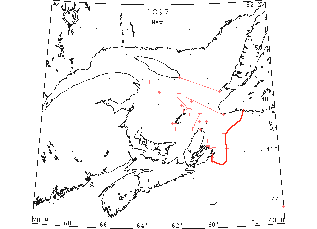
May 1 SS “Numidian” entered field ice 10 miles SE from Cape Ray and cleared it May 4 in 48°18’N 61°20’W. (HB #402 May 12)
May 1 Meat Cove, calm, thick fog. Amherst, Magdalen Islands, light, open ice distant; moderate northeast wind. East Point, Magdalens, closed packed ice as far as can be seen; stationary. ([HH?] 03/05/1897 p7#2)
May 3 SS “Lycia” passed heavy field ice off St. Pauls Rocks. 4th, 47°37’N 60°32’W passed close field and pack ice all day. 5th, saw the last of the ice in 47°N 61°W. (HB #402 May 12)
May 3 SS “Castlemoor” found Sydney Bay blocked with slob ice from Glace Bay as far northward as could be seen. 4th, ice very compact, ship lay to overnight, position at 8 am, 46°13’N 59°45’W. 5th, dense fog, ship lying to in the ice. 6th, 45°50’N 59°53’W coast blocked with ice to W and N as far as could be seen from masthead. Later in the day we ran into Louisburg for shelter from the moving ice. Lying at Louisburg until May 12. Heavy field ice 5 miles off shore from Louisburg extending as far as could be seen. (HB #404 May 26)
May 3 Low Point, CB, ice everywhere; no open water to be seen. Meat Cove, light open ice inshore. Amherst, Mag Isle, heavy body of ice to westward; open water northward; no water eastward and southward. (HH 04/05/1897 p7#2)
May 4 SS “Scotsman” met drift ice near Bird Rocks. The field extended 12 or 15 miles in a WSW direction. (HB #402 May 12)
May 4 SS “Ormidale” 48°06’N 61°W passed a large quantity of field ice. 5th, sailed 40 miles NW through field ice after passing Bird Rocks. (HB #402 May 12)
May 4 Meat Cove, CB, no ice. East Point, Magdalen Islds, heavy open ice distant. (HH 05/05/1897 p7#2)
May 5 SS “Polino” at St. John’s damaged by ice in the Gulf. (NYMR)
May 5 SS “Monte Rosa” 43°40’N 56°W passed through field ice for ¼ mile. (HB #403 May 19)
May 6 SS “Nicosian” 46°46’N 59°08’W pass much heavy field ice. 7th, 48°26’N 61°45’W passed great quantities of ice. Many vessels are fast in the ice. (HB #403 May 19)
May 6 Meat Cove, CB, moderate north; light open ice distant. West Point, Magdalens – Heavy open ice as far as can be seen moving south west. (HH 07/05/1897 p7#2)
May 7 SS “Rossmore” met a great quantity of field ice about 10 miles ESE of Bird Rocks which continued 30 miles on a WNW direction. S of it the ice seemed to be packed in a continuous field as far as the eye could reach. (HB #402 May 12)
May 7 SS “Loughrigg Holme” passed much field ice in the Gulf of St. Lawrence. (HB #403 May 19)
May 8 Meat Cove, CB, strong north east wind, thick snow. West Point, Magdalen Islands, heavy open ice everywhere moving southwest. (HH 10/05/1897 p7#3)
May 9 SS “Ramore Head” 48°29’N 62°55’W met a large quantity of field ice which we cleared 6 hours later on our northwestward course. (HB #404 May 26)
May 10 SS “Arecuna” 46°10’N 59°W passed to northward of 3 large ice fields. Could not get within 8 miles of Sydney, CB on account of the ice but found the entrance to Louisburg clear. (HB #403 May 19)
May 10 Schooner “Eliza H. Parkhurst” was 2 weeks in the ice between Cape St. George and Anticosti prior to May 10. (Boston Advertiser) (HB #404 May 26)
May 11 Meat Cove, a string of ice a mile wide along shore, moving southeast; no ice reported or seen from any other gulf station. (HH 12/05/1897 p7#2)
May 11 The steamer “Areonna” arrived Tuesday evening from Greenock. The steamer was supposed to have called at Sydney for orders. Captain Houston reports that he tried to enter that port, but was prevented by ice blockade. He then came on to Halifax. The captain reports seeing several steamers in the ice off Sydney. One of them is thought to be the “Harlow.” (HH 13/05/1897 p2#4)
May 12 Meat Cove, a strip of loose ice a mile wide on the coast moving east is all the ice reported in the gulf. (HH 13/05/1897 p7#2)
May 24 SS “Admiral” from Grimsby to Iceland sunk by ice off North Cape, CBI. (PR).
May 31 Barkentine “Laura” from Sydney, CBI to St. John’s cut through by ice and sank in ‘Connoir Bay”. (PR).